(OAD) Document for Ozone Mapping and Profiler Suite ... - NASA
(OAD) Document for Ozone Mapping and Profiler Suite ... - NASA
(OAD) Document for Ozone Mapping and Profiler Suite ... - NASA

Create successful ePaper yourself
Turn your PDF publications into a flip-book with our unique Google optimized e-Paper software.
<strong>OAD</strong> – OMPS TC EDR D37031<br />
Rev C5<br />
Page 13<br />
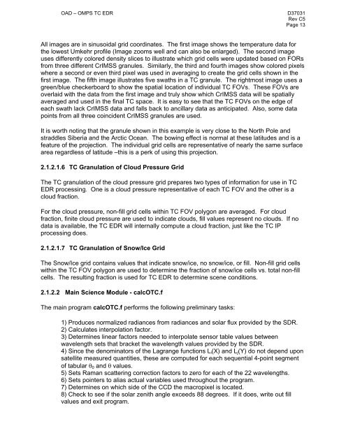
All images are in sinusoidal grid coordinates. The first image shows the temperature data <strong>for</strong><br />
the lowest Umkehr profile (Image zooms well <strong>and</strong> can also be enlarged). The second image<br />
uses differently colored density slices to illustrate which grid cells were updated based on FORs<br />
from three different CrIMSS granules. Similarly, the third <strong>and</strong> fourth images show colored pixels<br />
where a second or even third pixel was used in averaging to create the grid cells shown in the<br />
first image. The fifth image illustrates five swaths in a TC granule. The rightmost image uses a<br />
green/blue checkerboard to show the spatial location of individual TC FOVs. These FOVs are<br />
overlaid with the data from the first image <strong>and</strong> truly show which CrIMSS data will be spatially<br />
averaged <strong>and</strong> used in the final TC space. It is easy to see that the TC FOVs on the edge of<br />
each swath lack CrIMSS data <strong>and</strong> falls back to ancillary data as anticipated. Also, some data<br />
points from all three coincident CrIMSS granules are used.<br />
It is worth noting that the granule shown in this example is very close to the North Pole <strong>and</strong><br />
straddles Siberia <strong>and</strong> the Arctic Ocean. The bowing effect is normal at these latitudes <strong>and</strong> is a<br />
feature of the projection. The individual grid cells are representative of nearly the same surface<br />
area regardless of latitude –this is a perk of using this projection.<br />
2.1.2.1.6 TC Granulation of Cloud Pressure Grid<br />
The TC granulation of the cloud pressure grid prepares two types of in<strong>for</strong>mation <strong>for</strong> use in TC<br />
EDR processing. One is a cloud pressure representative of each TC FOV <strong>and</strong> the other is a<br />
cloud fraction.<br />
For the cloud pressure, non-fill grid cells within TC FOV polygon are averaged. For cloud<br />
fraction, finite cloud pressure are used to indicate clouds, fill values represent no clouds. If no<br />
data is available, the TC EDR will internally compute a cloud fraction, just like the TC IP<br />
processing does.<br />
2.1.2.1.7 TC Granulation of Snow/Ice Grid<br />
The Snow/Ice grid contains values that indicate snow/ice, no snow/ice, or fill. Non-fill grid cells<br />
within the TC FOV polygon are used to determine the fraction of snow/ice cells vs. total non-fill<br />
cells. The resulting fraction is used <strong>for</strong> TC EDR to determine scene conditions.<br />
2.1.2.2 Main Science Module - calcOTC.f<br />
The main program calcOTC.f per<strong>for</strong>ms the following preliminary tasks:<br />
1) Produces normalized radiances from radiances <strong>and</strong> solar flux provided by the SDR.<br />
2) Calculates interpolation factor.<br />
3) Determines linear factors needed to interpolate sensor table values between<br />
wavelength sets that bracket the wavelength values provided by the SDR.<br />
4) Since the denominators of the Lagrange functions Li(X) <strong>and</strong> Lj(Y) do not depend upon<br />
satellite measured quantities, these are computed <strong>for</strong> each sequential 4-point segment<br />
of tabular �0 <strong>and</strong> � values.<br />
5) Sets Raman scattering correction factors to zero <strong>for</strong> each of the 22 wavelengths.<br />
6) Sets pointers to alias actual variables used throughout the program.<br />
7) Determines on which side of the CCD the macropixel is located.<br />
8) Check to see if the solar zenith angle exceeds 88 degrees. If it does, write out fill<br />
values <strong>and</strong> exit program.