(OAD) Document for Ozone Mapping and Profiler Suite ... - NASA
(OAD) Document for Ozone Mapping and Profiler Suite ... - NASA
(OAD) Document for Ozone Mapping and Profiler Suite ... - NASA
Create successful ePaper yourself
Turn your PDF publications into a flip-book with our unique Google optimized e-Paper software.
<strong>OAD</strong> – OMPS TC EDR D37031<br />
Rev C5<br />
Page 28<br />
2.1.4 Exception H<strong>and</strong>ling<br />
Pre-processing screening of input radiances, observational angles, satellite attitude in<strong>for</strong>mation<br />
<strong>and</strong> sensor status is done within the SDR algorithm. During EDR processing, data quality flags<br />
are broken into two categories: geophysical conditions of interest to the scientific/operational<br />
community that do not degrade data quality; <strong>and</strong> those that do degrade data quality. Although<br />
not part of the delivered code, we describe in the paragraphs below, error h<strong>and</strong>ling <strong>for</strong> both the<br />
SDR <strong>and</strong> EDR algorithm.<br />
2.1.4.1 SDR Algorithm<br />
Be<strong>for</strong>e measured NRs are accepted <strong>for</strong> use in ozone determination, the solar zenith angle,<br />
satellite attitude, <strong>and</strong> instrument status are checked to ensure the suitability of the NRs <strong>and</strong><br />
other geophysical input to the algorithm. If the solar zenith angle is greater than 88 degrees<br />
EDR processing is not per<strong>for</strong>med.<br />
Using the geolocation data <strong>for</strong> the beginning <strong>and</strong> end of each observation, the SDR algorithm<br />
checks the ground track of the satellite during an observation <strong>and</strong> compares it with a static SAA<br />
map of relative radiation exposure. The algorithm flags each swath according to the percentage<br />
of expected exposure. For example, if the calculated exposure is 45% the data are flagged as<br />
exceeding 40% but not 50%. Flagging in 10% exposure gradations with an 80% maximum is<br />
adequate, so results are conveniently packed in an 8 bit word.<br />
The algorithm also per<strong>for</strong>ms transient pixel detection by comparison with nearest neighbors. A<br />
cubic spline, or similar smooth regression, is per<strong>for</strong>med along each row J (i.e. spectrally) <strong>for</strong><br />
each data cell. The splined region should not exceed 2 nm. A gradated flag, similar to that<br />
used <strong>for</strong> the SAA, is used to indicate the percent by which the measured radiance exceeds that<br />
computed from the spline. Macropixels that have lower than expected radiances are not<br />
flagged by this algorithm.<br />
Using an almanac of Solar eclipses by the moon, the algorithm checks the latitude <strong>and</strong><br />
longitude of the Earth data <strong>for</strong> the presence of a solar eclipse at each Earth spatial cell. If the<br />
FOV lies within an eclipse, the algorithm flags the FOV <strong>for</strong> eclipses <strong>and</strong> EDR processing is not<br />
per<strong>for</strong>med.<br />
Specular reflections of sunlight off water surfaces are a geophysical situation not properly<br />
incorporated in the EDR radiance tables. When the sun glint condition is met, water reflects<br />
much of the solar irradiation at a solar zenith angle �o into the sensor field of view at a satellite<br />
zenith angle �. Waves diffuse the reflection, creating a range of angles <strong>for</strong> which sun glint<br />
produces an error. This includes reflections out of the principal plane, i.e. relative azimuth angle<br />
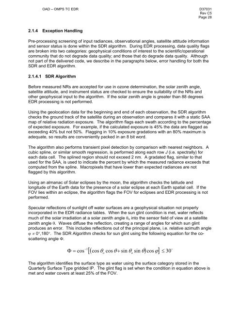
� � 0�,180�. The SDR Algorithm checks <strong>for</strong> sun glint using the following equation <strong>for</strong> the coscattering<br />
angle �.<br />
� �<br />
cos 1 �<br />
�<br />
��cos cos�<br />
� sin � sin ��cos��<br />
� 30<br />
�o o<br />
The algorithm identifies the surface type as water using the surface category stored in the<br />
Quarterly Surface Type gridded IP. The glint flag is set when the condition in equation above is<br />
met <strong>and</strong> water covers at least 25% of the FOV.


