Chapter 11: Weather Theory - FAA
Chapter 11: Weather Theory - FAA
Chapter 11: Weather Theory - FAA

You also want an ePaper? Increase the reach of your titles
YUMPU automatically turns print PDFs into web optimized ePapers that Google loves.
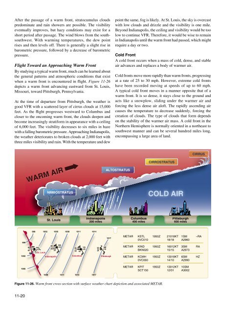
After the passage of a warm front, stratocumulus cloudspredominate and rain showers are possible. The visibilityeventually improves, but hazy conditions may exist for ashort period after passage. The wind blows from the southsouthwest.With warming temperatures, the dew pointrises and then levels off. There is generally a slight rise inbarometric pressure, followed by a decrease of barometricpressure.Flight Toward an Approaching Warm FrontBy studying a typical warm front, much can be learned aboutthe general patterns and atmospheric conditions that existwhen a warm front is encountered in flight. Figure <strong>11</strong>-26depicts a warm front advancing eastward from St. Louis,Missouri, toward Pittsburgh, Pennsylvania.At the time of departure from Pittsburgh, the weather isgood VFR with a scattered layer of cirrus clouds at 15,000feet. As the flight progresses westward to Columbus andcloser to the oncoming warm front, the clouds deepen andbecome increasingly stratiform in appearance with a ceilingof 6,000 feet. The visibility decreases to six miles in hazewith a falling barometric pressure. Approaching Indianapolis,the weather deteriorates to broken clouds at 2,000 feet withthree miles visibility and rain. With the temperature and dewpoint the same, fog is likely. At St. Louis, the sky is overcastwith low clouds and drizzle and the visibility is one mile.Beyond Indianapolis, the ceiling and visibility would be toolow to continue VFR. Therefore, it would be wise to remainin Indianapolis until the warm front had passed, which mightrequire a day or two.Cold FrontA cold front occurs when a mass of cold, dense, and stableair advances and replaces a body of warmer air.Cold fronts move more rapidly than warm fronts, progressingat a rate of 25 to 30 mph. However, extreme cold frontshave been recorded moving at speeds of up to 60 mph.A typical cold front moves in a manner opposite that of awarm front. It is so dense, it stays close to the ground andacts like a snowplow, sliding under the warmer air andforcing the less dense air aloft. The rapidly ascending aircauses the temperature to decrease suddenly, forcing thecreation of clouds. The type of clouds that form dependson the stability of the warmer air mass. A cold front in theNorthern Hemisphere is normally oriented in a northeast tosouthwest manner and can be several hundred miles long,encompassing a large area of land.CIRRUSWARM AIRALTOSTRATUSCIRROSTRATUSNIMBOSTRATUSCOLD AIRSt. LouisIndianapolis200 milesColumbus400 milesPittsburgh600 miles999 1002 1005 1008 10<strong>11</strong> 1014999100265 0201651010 St. Louis59 0683 4059 56125206 2650 60IndianapolisColumbus531034166181017PittsburghMETAR KSTL 1950Z 21018KT 1SM –RA0VC010 18/18 A2960METAR KIND 1950Z 16012KT 3SM RABKN020 15/15 A2973METAR KCMH 1950Z 13018KT 6SM HZ0VC060 14/10 A29901005METAR KPIT 1950Z 13012KT 10SMSCT150 12/01 A30021008 10<strong>11</strong> 1014 1017Figure <strong>11</strong>-26. Warm front cross-section with surface weather chart depiction and associated METAR.<strong>11</strong>-20