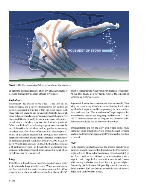
AnvilHailMOVEMENT OF STORMFigure <strong>11</strong>-29. Movement and turbulence of a maturing thunderstorm.of lightning and precipitation. Thus, any cloud connected toa severe thunderstorm carries a threat of violence.TurbulencePotentially hazardous turbulence is present in allthunderstorms, and a severe thunderstorm can destroy anaircraft. Strongest turbulence within the cloud occurs withshear between updrafts and downdrafts. Outside the cloud,shear turbulence has been encountered several thousand feetabove and 20 miles laterally from a severe storm. A low-levelturbulent area is the shear zone associated with the gust front.Often, a “roll cloud” on the leading edge of a storm marks thetop of the eddies in this shear and it signifies an extremelyturbulent zone. Gust fronts often move far ahead (up to 15miles) of associated precipitation. The gust front causes arapid and sometimes drastic change in surface wind ahead ofan approaching storm. Advisory Circular (AC) 00-50A, LowLevel Wind Shear, explains in detail the hazards associatedwith gust fronts. Figure 1 in the AC shows a schematic trusssection of a thunderstorm with areas outside the cloud whereturbulence may be encountered.IcingUpdrafts in a thunderstorm support abundant liquid waterwith relatively large droplet sizes. When carried abovethe freezing level, the water becomes supercooled. Whentemperature in the upward current cools to about –15 °C,much of the remaining water vapor sublimates as ice crystals.Above this level, at lower temperatures, the amount ofsupercooled water decreases.Supercooled water freezes on impact with an aircraft. Clearicing can occur at any altitude above the freezing level, but athigh levels, icing from smaller droplets may be rime or mixedrime and clear ice. The abundance of large, supercooledwater droplets makes clear icing very rapid between 0 °C and–15 °C and encounters can be frequent in a cluster of cells.Thunderstorm icing can be extremely hazardous.Thunderstorms are not the only area where pilots couldencounter icing conditions. Pilots should be alert for icinganytime the temperature approaches 0 °C and visible moistureis present.HailHail competes with turbulence as the greatest thunderstormhazard to aircraft. Supercooled drops above the freezing levelbegin to freeze. Once a drop has frozen, other drops latch onand freeze to it, so the hailstone grows—sometimes into ahuge ice ball. Large hail occurs with severe thunderstormswith strong updrafts that have built to great heights.Eventually, the hailstones fall, possibly some distance fromthe storm core. Hail may be encountered in clear air severalmiles from thunderstorm clouds.<strong>11</strong>-24
As hailstones fall through air whose temperature is above0 °C, they begin to melt and precipitation may reach theground as either hail or rain. Rain at the surface does notmean the absence of hail aloft. Possible hail should beanticipated with any thunderstorm, especially beneath theanvil of a large cumulonimbus. Hailstones larger than onehalfinch in diameter can significantly damage an aircraftin a few seconds.Ceiling and VisibilityGenerally, visibility is near zero within a thunderstormcloud. Ceiling and visibility also may be restricted inprecipitation and dust between the cloud base and the ground.The restrictions create the same problem as all ceiling andvisibility restrictions; but the hazards are multiplied whenassociated with the other thunderstorm hazards of turbulence,hail, and lightning.Effect on AltimetersPressure usually falls rapidly with the approach of athunderstorm, rises sharply with the onset of the first gustand arrival of the cold downdraft and heavy rain showers,and then falls back to normal as the storm moves on. Thiscycle of pressure change may occur in 15 minutes. If the pilotdoes not receive a corrected altimeter setting, the altimetermay be more than 100 feet in error.Engine Water IngestionTurbine engines have a limit on the amount of water theycan ingest. Updrafts are present in many thunderstorms,particularly those in the developing stages. If the updraftvelocity in the thunderstorm approaches or exceeds theterminal velocity of the falling raindrops, very highconcentrations of water may occur. It is possible that theseconcentrations can be in excess of the quantity of waterturbine engines are designed to ingest. Therefore, severethunderstorms may contain areas of high water concentrationwhich could result in flameout and/or structural failure ofone or more engines.<strong>Chapter</strong> SummaryKnowledge of the atmosphere and the forces acting withinit to create weather is essential to understand how weatheraffects a flight. By understanding basic weather theories, apilot can make sound decisions during flight planning afterreceiving weather briefings. For additional information onthe topics discussed in this chapter, see AC 00-6, Aviation<strong>Weather</strong> For Pilots and Flight Operations Personnel;AC 00-24, Thunderstorms; AC 00-45, Aviation <strong>Weather</strong>Services; AC 91-74, Pilot Guide Flight in Icing Conditions;and chapter 7, section 2 of the Aeronautical InformationManual (AIM).LightningA lightning strike can puncture the skin of an aircraftand damage communications and electronic navigationalequipment. Although lightning has been suspected of ignitingfuel vapors and causing an explosion, serious accidents dueto lightning strikes are rare. Nearby lightning can blind thepilot, rendering him or her momentarily unable to navigateeither by instrument or by visual reference. Nearby lightningcan also induce permanent errors in the magnetic compass.Lightning discharges, even distant ones, can disrupt radiocommunications on low and medium frequencies. Thoughlightning intensity and frequency have no simple relationshipto other storm parameters, severe storms, as a rule, have ahigh frequency of lightning.<strong>11</strong>-25