HORNBY - Lancashire County Council
HORNBY - Lancashire County Council
HORNBY - Lancashire County Council

You also want an ePaper? Increase the reach of your titles
YUMPU automatically turns print PDFs into web optimized ePapers that Google loves.
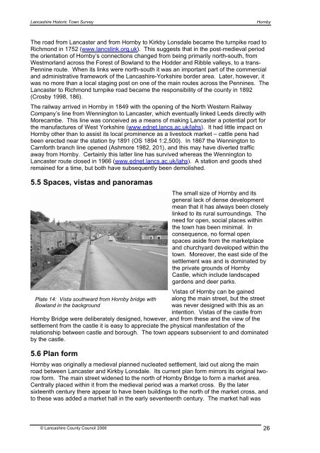
<strong>Lancashire</strong> Historic Town SurveyHornbyThe road from Lancaster and from Hornby to Kirkby Lonsdale became the turnpike road toRichmond in 1752 (www.lancslink.org.uk). This suggests that in the post-medieval periodthe orientation of Hornby’s connections changed from being primarily north-south, fromWestmorland across the Forest of Bowland to the Hodder and Ribble valleys, to a trans-Pennine route. When its links were north-south it was an important part of the commercialand administrative framework of the <strong>Lancashire</strong>-Yorkshire border area. Later, however, itwas no more than a local staging post on one of the main routes across the Pennines. TheLancaster to Richmond turnpike road became the responsibility of the county in 1892(Crosby 1998, 186).The railway arrived in Hornby in 1849 with the opening of the North Western RailwayCompany’s line from Wennington to Lancaster, which eventually linked Leeds directly withMorecambe. This line was conceived as a means of making Lancaster a potential port forthe manufactures of West Yorkshire (www.ednet.lancs.ac.uk/lahs). It had little impact onHornby other than to assist its local prominence as a livestock market – cattle pens hadbeen erected near the station by 1891 (OS 1894 1:2,500). In 1867 the Wennington toCarnforth branch line opened (Ashmore 1982, 201), and this may have diverted trafficaway from Hornby. Certainly this latter line has survived whereas the Wennington toLancaster route closed in 1966 (www.ednet.lancs.ac.uk/lahs). A station and goods shedremained for a time, but both have subsequently been demolished.5.5 Spaces, vistas and panoramasPlate 14: Vista southward from Hornby bridge withBowland in the backgroundThe small size of Hornby and itsgeneral lack of dense developmentmean that it has always been closelylinked to its rural surroundings. Theneed for open, social places withinthe town has been minimal. Inconsequence, no formal openspaces aside from the marketplaceand churchyard developed within thetown. Moreover, the east side of thesettlement was and is dominated bythe private grounds of HornbyCastle, which include landscapedgardens and deer parks.Vistas of Hornby can be gainedalong the main street, but the streetwas never designed with this as anintention. Vistas of the castle fromHornby Bridge were deliberately designed, however, and from these and the view of thesettlement from the castle it is easy to appreciate the physical manifestation of therelationship between castle and borough. The town appears subservient to and dominatedby the castle.5.6 Plan formHornby was originally a medieval planned nucleated settlement, laid out along the mainroad between Lancaster and Kirkby Lonsdale. Its current plan form mirrors its original tworowform. The main street widened to the north of Hornby Bridge to form a market area.Centrally placed within it from the medieval period was a market cross. By the latersixteenth century there appear to have been buildings to the north of the market cross, andto these was added a market hall in the early seventeenth century. The market hall was© <strong>Lancashire</strong> <strong>County</strong> <strong>Council</strong> 2006 26