

Victorian Subtidal Reef Monitoring Program - Parks Victoria
Victorian Subtidal Reef Monitoring Program - Parks Victoria
Victorian Subtidal Reef Monitoring Program - Parks Victoria

You also want an ePaper? Increase the reach of your titles
YUMPU automatically turns print PDFs into web optimized ePapers that Google loves.
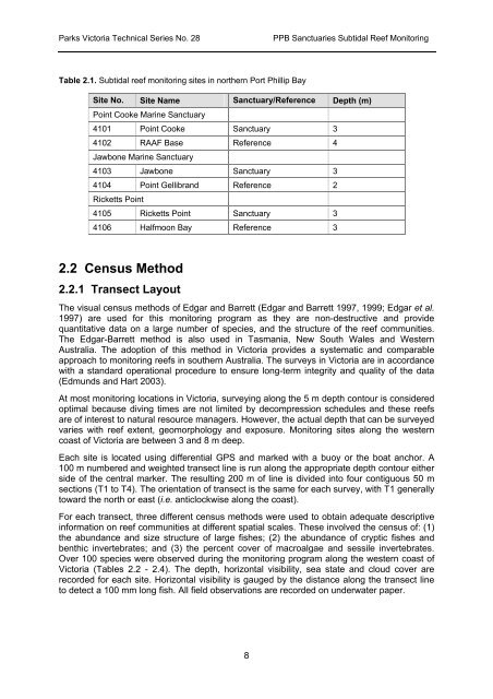
<strong>Parks</strong> <strong>Victoria</strong> Technical Series No. 28PPB Sanctuaries <strong>Subtidal</strong> <strong>Reef</strong> <strong>Monitoring</strong>Table 2.1. <strong>Subtidal</strong> reef monitoring sites in northern Port Phillip BaySite No. Site Name Sanctuary/Reference Depth (m)Point Cooke Marine Sanctuary4101 Point Cooke Sanctuary 34102 RAAF Base Reference 4Jawbone Marine Sanctuary4103 Jawbone Sanctuary 34104 Point Gellibrand Reference 2Ricketts Point4105 Ricketts Point Sanctuary 34106 Halfmoon Bay Reference 32.2 Census Method2.2.1 Transect LayoutThe visual census methods of Edgar and Barrett (Edgar and Barrett 1997, 1999; Edgar et al.1997) are used for this monitoring program as they are non-destructive and providequantitative data on a large number of species, and the structure of the reef communities.The Edgar-Barrett method is also used in Tasmania, New South Wales and WesternAustralia. The adoption of this method in <strong>Victoria</strong> provides a systematic and comparableapproach to monitoring reefs in southern Australia. The surveys in <strong>Victoria</strong> are in accordancewith a standard operational procedure to ensure long-term integrity and quality of the data(Edmunds and Hart 2003).At most monitoring locations in <strong>Victoria</strong>, surveying along the 5 m depth contour is consideredoptimal because diving times are not limited by decompression schedules and these reefsare of interest to natural resource managers. However, the actual depth that can be surveyedvaries with reef extent, geomorphology and exposure. <strong>Monitoring</strong> sites along the westerncoast of <strong>Victoria</strong> are between 3 and 8 m deep.Each site is located using differential GPS and marked with a buoy or the boat anchor. A100 m numbered and weighted transect line is run along the appropriate depth contour eitherside of the central marker. The resulting 200 m of line is divided into four contiguous 50 msections (T1 to T4). The orientation of transect is the same for each survey, with T1 generallytoward the north or east (i.e. anticlockwise along the coast).For each transect, three different census methods were used to obtain adequate descriptiveinformation on reef communities at different spatial scales. These involved the census of: (1)the abundance and size structure of large fishes; (2) the abundance of cryptic fishes andbenthic invertebrates; and (3) the percent cover of macroalgae and sessile invertebrates.Over 100 species were observed during the monitoring program along the western coast of<strong>Victoria</strong> (Tables 2.2 - 2.4). The depth, horizontal visibility, sea state and cloud cover arerecorded for each site. Horizontal visibility is gauged by the distance along the transect lineto detect a 100 mm long fish. All field observations are recorded on underwater paper.8


