

Draft Plan of Management for Tyalgum Public Recreation and ... - Land
Draft Plan of Management for Tyalgum Public Recreation and ... - Land
Draft Plan of Management for Tyalgum Public Recreation and ... - Land

Create successful ePaper yourself
Turn your PDF publications into a flip-book with our unique Google optimized e-Paper software.
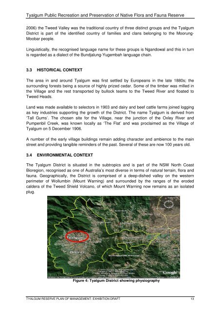
<strong>Tyalgum</strong> <strong>Public</strong> <strong>Recreation</strong> <strong>and</strong> Preservation <strong>of</strong> Native Flora <strong>and</strong> Fauna Reserve2006) the Tweed Valley was the traditional country <strong>of</strong> three distinct groups <strong>and</strong> the <strong>Tyalgum</strong>District is part <strong>of</strong> the identified country <strong>of</strong> families <strong>and</strong> clans belonging to the Moorung-Moobar people.Linguistically, the recognised language name <strong>for</strong> these groups is Ng<strong>and</strong>owal <strong>and</strong> this in turnis regarded as a dialect <strong>of</strong> the Bundjalung-Yugembah language chain.3.3 HISTORICAL CONTEXTThe area in <strong>and</strong> around <strong>Tyalgum</strong> was first settled by Europeans in the late 1880s; thesurrounding <strong>for</strong>ests being a source <strong>of</strong> highly prized cedar. Some <strong>of</strong> the timber was milled inthe Village <strong>and</strong> the rest transported by bullock teams to the Tweed River <strong>and</strong> floated toTweed Heads.L<strong>and</strong> was made available to selectors in 1903 <strong>and</strong> dairy <strong>and</strong> beef cattle farms joined loggingas key industries supporting the growth <strong>of</strong> the District. The name <strong>Tyalgum</strong> is derived from‘Tall Gums’. The chosen site <strong>for</strong> the Village, near the junction <strong>of</strong> the Oxley River <strong>and</strong>Pumpenbil Creek, was known locally as ‘The Flat’ <strong>and</strong> was proclaimed as the Village <strong>of</strong><strong>Tyalgum</strong> on 5 December 1906.A number <strong>of</strong> the early village buildings remain adding character <strong>and</strong> ambience to the mainstreet <strong>and</strong> providing tangible reminders <strong>of</strong> the past. Several <strong>of</strong> these are now 100 years old.3.4 ENVIRONMENTAL CONTEXTThe <strong>Tyalgum</strong> District is situated in the subtropics <strong>and</strong> is part <strong>of</strong> the NSW North CoastBioregion, recognised as one <strong>of</strong> Australia’s most diverse in terms <strong>of</strong> natural terrain, flora <strong>and</strong>fauna. Geographically, the District is comprised <strong>of</strong> a deep-dished valley on the westernperimeter <strong>of</strong> Wollumbin (Mount Warning) <strong>and</strong> surrounded by the ranges <strong>of</strong> the erodedcaldera <strong>of</strong> the Tweed Shield Volcano, <strong>of</strong> which Mount Warning now remains as an isolatedplug.Figure 4: <strong>Tyalgum</strong> District showing physiographyTYALGUM RESERVE PLAN OF MANAGEMENT: EXHIBITION DRAFT 13


