

COMPOSITIONAL DATA : GAS : GAS PROPERTIES Puffin Fm RFT ...
COMPOSITIONAL DATA : GAS : GAS PROPERTIES Puffin Fm RFT ...
COMPOSITIONAL DATA : GAS : GAS PROPERTIES Puffin Fm RFT ...

Create successful ePaper yourself
Turn your PDF publications into a flip-book with our unique Google optimized e-Paper software.
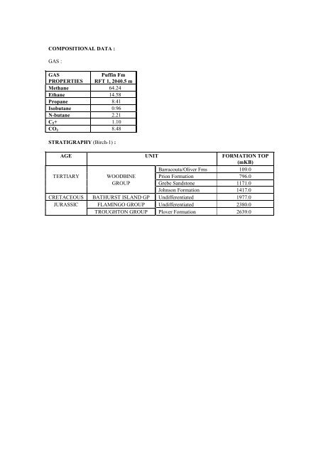
<strong>COMPOSITIONAL</strong> <strong>DATA</strong> :<strong>GAS</strong> :<strong>GAS</strong><strong>PROPERTIES</strong><strong>Puffin</strong> <strong>Fm</strong><strong>RFT</strong> 1, 2040.5 mMethane 64.24Ethane 14.58Propane 8.41Isobutane 0.96N-butane 2.21C 5 + 1.10CO 2 8.48STRATIGRAPHY (Birch-1) :AGE UNIT FORMATION TOP(mKB)Barracouta/Oliver <strong>Fm</strong>s 109.0TERTIARY WOODBINE Prion Formation 796.0GROUP Grebe Sandstone 1171.0Johnson Formation 1417.0CRETACEOUS BATHURST ISLAND GP Undifferentiated 1977.0JURASSIC FLAMINGO GROUP Undifferentiated 2380.0TROUGHTON GROUP Plover Formation 2639.0
Accumulation Number: 8BLACKTIPORIGINAL OPERATOR:Woodside Energy LtdTYPE:GasSTATUS:Other DiscoveryLOCATION:300 km southwest of DarwinSTATE:Western AustraliaORIGINAL TITLE(S):WA-279-PBASIN:BonaparteSUB-BASIN:Petrel Sub-basinDISCOVERY WELL:Blacktip-1Longitude (E): 128.4847Latitude (S): -13.9041Date total depth reached: 10 AUG 01Water Depth:55.2 mOperator:Woodside Energy LtdTotal Depth:3,181 mRTNUMBER OF WELLS DRILLED: 1RESERVOIR UNITS:3 (multiple reservoir sands)GROSS HYDROCARBON COLUMN: 339 m (Keyling Formation)20 m (Mt Goodwin Formation)PETROLEUM BEARING UNIT No.1:CONTENTS:FORMATION:PETROLEUM BEARING UNIT No.2:CONTENTS:FORMATION:PETROLEUM BEARING UNIT No.3:CONTENTS:FORMATION:Kinmore GroupGasMt Goodwin FormationKulshill GroupGasKeyling Formation (multiple reservoirs)Kulshill GroupGasTreachery FormationRESERVES:Gas:Condensate:1.139 TCF1.9 MMbblsSource: Department of Industry and Resources, Western Australia, 2002.REMARKS:No further information on the Blacktip discovery is available at date of publication.
Accumulation Number: 10BONAPARTEORIGINAL OPERATOR:Alliance Oil Development AustraliaTYPE:GasSTATUS:Other DiscoveryLOCATION:375 km southwest of DarwinSTATE:Western AustraliaORIGINAL TITLE(S):PE 127 HBASIN:BonaparteSUB-BASIN:Petrel Sub-basinDISCOVERY WELL:Bonaparte-2Longitude (E): 128.7211Latitude (S): -15.0853Date total depth reached: 09 OCT 64Ground level:117 mKelly bushing:5 mOperator:Alliance Oil Development Australia.Total Depth:2,136 mKBNUMBER OF WELLS DRILLED: 2STRUCTURE/TRAP:Northwest-southeast trending anticlineAREAL CLOSURE: > 50 km 2VERTICAL CLOSURE:> 75 mRESERVOIR UNITS: 1PETROLEUM BEARING UNIT No.1: Weaber GroupCONTENTS:GasFORMATION:Milligans FormationAGE:Early CarboniferousLITHOLOGY:Argillaceous sandstone interbedded with carbonaceoussiltstone and shale.DEPOSITIONAL ENVIRONMENT: Moderately deepwater marineFORMATION TOP (mKB):480.7 mKB (top Milligans <strong>Fm</strong>)1,437.4 mKB (top reservoir)POROSITY: Up to 16%TEST <strong>DATA</strong> FROM THE DISCOVERY WELL (Bonaparte-2):DST 1, 460-523 m,Recovered 55 m of slightly water cutdrilling mud and 289 m of fresh water.DST 2, 524-586.9 m,Recovered 6 m of watery drilling mudand 120 m of fresh water.DST 3, 1,001-1,024.9 m,Recovered 1.5 m of drilling mud.Tanmurra FormationMilligans FormationMilligans FormationDST 4, 1,067.9-1,088.9 m,Recovered 58 m of drilling mud.Milligans FormationDST 5, 1,379.9-1,389.1 m, Milligans FormationRecovered 76 m of water cut drillingmud and 870 m of salt water.
DST 14, 1,431.1-1,451.1 m,Flowed gas at 29,000 m 3 /day andrecovered 41 m of drilling mud.DST 6, 1,436-1,469.2 m,Flowed gas at 43,500 m 3 /day andrecovered 3 m of gassy drilling mud.Milligans FormationMilligans FormationDST 7, 1,451.1-1,490.2 m, Milligans FormationRecovered 244 m of watery drillingmud and 829 m of slightly mud cutsalty water.DST 12, 1,738.8-1,746.1 m,Misrun.DST 13, 1,741.1-1,748 m,Recovered 131 m of salty water.DST 11, 1,846.1-1,883.9 m,Recovered 122 m of watery drillingmud and 223 m of salt water.DST 8, 1,962.9-1,988.8 m,Recovered 199 m of drilling mud.DST 9, 2,044.9-2,074.1 m,Misrun.DST 10, 2,049.9-2,087.9 m,Recovered 46 m of drilling mud.Milligans FormationMilligans FormationMilligans FormationMilligans FormationBonaparte FormationBonaparte FormationAPPRAISAL AND DEVELOPMENT DRILLING:Bonaparte-1, located 8 km to the north-northeast of Bonaparte-2, was drilled as a stratigraphic test. ADST taken over the interval 1,715 – 1,736 mKB in the Milligans Formation recovered a quantity of gascut,salty water.REMARKS:The gas bearing sandstones encountered in the Milligans Formation in Bonaparte-2 were retested afterthe well reached total depth. A maximum stabilised flow rate of 32,500 m 3 /day was attained. Bonaparte-2 was plugged and abandoned as the gas discovery was thought to be uneconomic.STRATIGRAPHY (Bonaparte-2) :AGE UNIT FORMATION TOP(mKB)WEABER Point Springs Sandstone 5.2CARBONIFEROUS GROUP Tanmurra Formation 185.3Milligans Formation 480.7DEVONIAN COCKATOO GP Bonaparte Formation 2034.5
Accumulation Number: 11BUFFALOORIGINAL OPERATOR:BHP Petroleum (Northwest Shelf) Pty LtdTYPE:OilSTATUS:ProducerLOCATION:550 km west-northwest of DarwinSTATE:Western AustraliaORIGINAL TITLE(S):WA-260-PBASIN:BonaparteSUB-BASIN:Laminaria High, Sahul PlatformDISCOVERY WELL:Buffalo-1Longitude (E): 126.0974Latitude (S): -10.6728Date total depth reached: 27 SEP 96Water Depth:27.3 mKelly bushing:28.3 mOperator:BHP Petroleum (Northwest Shelf) Pty LtdTotal Depth:3,473 mKBNUMBER OF WELLS DRILLED: 2STRUCTURE/TRAP:Faulted horst block with some internal four-way-dipclosure.RESERVOIR UNITS: 1OIL GRAVITY:53 o API<strong>GAS</strong> TO OIL RATIO:126 scf/stbPETROLEUM BEARING UNIT No.1: Elang FormationCONTENTS:OilFORMATION:Elang FormationAGE:Middle Jurassic (Callovian)LITHOLOGY:Stacked sandstones, interbedded with minor argillaceoussiltstones, silty claystones and claystone. Sandstone: verylight grey to yellowish grey to light olive grey, very fine tofine, medium to carse grained, well sorted, commonlyunconsolidated, friable with minor pyritic matrix and weaksiliceous cement.DEPOSITIONAL ENVIRONMENT:: Stacked distributary channels deposited in an estuarineenvironment superposed upon a sequence of stacked mouthand transverse bars.GROSS HYDROCARBON COLUMN: 45.1 m (3,301 – 3,346.1 mRT)NET PAY:32 mNET TO GROSS RATIO: 72%HYDROCARBON SATURATION: 77%OIL/WATER CONTACT:3,323.4 mTVDSS (free water level from MDT data)POROSITY:12% (average log porosity)PERMEABILITY:378 mD (average from core)TEST <strong>DATA</strong> FROM THE DISCOVERY WELL (Buffalo-1):DST (CASED) 1, 3,307-3,335 m,Flowed 53 o API oil at 11,800 bbls/dayand gas at 328,500 m 3 /day through a20.6 mm choke.Elang Formation
APPRAISAL AND DEVELOPMENT DRILLING:Buffalo-2 was drilled in April 1997 and was suspended as future oil producer after encounteringhydrocarbons in the Elang Formation.RESERVES :Oil :25 MMbblsSource: Department of Resources Development, Western Australia, 1998.REMARKS:Commercial production of oil from Buffalo commenced in December 1999. Two production wells areconnected to to an unmanned wellhead platform which is linked to a permanently moored FPSO (theBuffalo Venture).The Buffalo oil discovery lies in Production Licenses WA-19-L and WA-21-L.
Accumulation Number: 12BULLERORIGINAL OPERATOR:BHP Petroleum (Northwest Shelf) Pty LtdTYPE:OilSTATUS:Other DiscoveryLOCATION:530 km west-northwest of DarwinSTATE:Western AustraliaORIGINAL TITLE(S):WA-260-PBASIN:BonaparteSUB-BASIN:Flamingo HighDISCOVERY WELL:Buller-1Longitude (E): 126.2403Latitude (S): -10.9077Date total depth reached: 13 DEC 96Water Depth:109 mKelly bushing:25 mOperator:BHP Petroleum (Northwest Shelf) Pty LtdTotal Depth:3,609 mKBNUMBER OF WELLS DRILLED: 1STRUCTURE/TRAP:Tilted fault block.AREAL CLOSURE: 1 km 2VERTICAL CLOSURE:180 mOIL GRAVITY:52 o API<strong>GAS</strong>/OIL RATIO:114 scf/stbPETROLEUM BEARING UNIT No.1: Troughton GroupCONTENTS:OilFORMATION:Elang FormationFORMATION TOP:3,421.5 mTVDSSAGE:CallovianLITHOLOGY:Stacked sandstone sequence, interbedded with siltyclaystones and claystones. Sandstone: light greyish brown,very light grey to mid grey, light olive grey, rare brownishblack, very fine to fine, medium to coarse grained,predominantly medium, poor to moderately well sorted,unconsolidated in part but mainly friable to firm. Commonto abundant weak quartz overgrowths with traces ofcarbonate cement and argillaceous matrix.DEPOSITIONAL ENVIRONMENT: Transgressive delta, comprising stacked distributorychannels and upper shoreface sands.GROSS HYDROCARBON COLUMN: 26.5 m (3,446.5 – 3,473 mRT)NET PAY:8.56 mNET TO GROSS RATIO: 32.3%HYDROCARBON SATURATION: 83.4%OIL/WATER CONTACT:3,448 mTVDSS (free water level)POROSITY:11.9% (core data)10.7% (average log)PERMEABILITY:369.7 mD (average from core)TEST <strong>DATA</strong> FROM THE DISCOVERY WELL (Buller-1):MDT 1, 3,440.7 mTVDSS,Recovered 16 litres of 52 o API oiland 0.15 m 3 of gas.Elang Formation
126°14'30"390036003800370036003500350036003700Buller 110°54'23"39003900390001 km4000Contour Interval 20mBuller, Top Elang Formation, depth map12/OA/205
REMARKS:Fluorescence recorded below the oil/water contact indicates the possible presence of a residual oilcolumn.<strong>COMPOSITIONAL</strong> <strong>DATA</strong> :<strong>GAS</strong> :<strong>GAS</strong><strong>PROPERTIES</strong>GasElang <strong>Fm</strong>(mole %)Methane 6.47Ethane 0.79Propane/Butane 6.28Pentane 6.17Hexane 14.07Heptane 15.46Octane 10.63Nonane 7.09Decane 4.82C 11 + 24.86N 2 0.45CO 2 2.91STRATIGRAPHY (Buller-1) :AGE UNIT FORMATION TOP(mTVDSS)Undifferentiated 109.0WOODBINE Oliver Formation 650.5TERTIARY GROUP Cartier Formation 1218.0Prion Formation 1267.5Hibernia Formation 1647.5Grebe Sandstone 1950.0BATHURST Johnson Formation 2021.0CRETACEOUS ISLAND Wangarlu Formation 2346.0GROUP Jamieson Formation 2731.0Darwin Formation 2968.0Echuca Shoals Formation 3064.5FLAMINGO Flamingo Formation 3109.0JURASSIC GROUP Frigate Formation 3403.5Elang Formation 3421.5TROUGHTON GP Plover Formation 3550.0
Accumulation Number: 13CASSINIORIGINAL OPERATOR:TYPE:STATUS:LOCATION:STATE:ORIGINAL TITLE(S):BASIN:SUB-BASIN:DISCOVERY WELL:Longitude (E): 124.9681Latitude (S): -12.1465Date total depth reached: 18 JUL 88Water Depth:116 mKelly bushing:26 mOperator:BHP Petroleum Pty LtdTotal Depth:1,724 mKBNUMBER OF WELLS DRILLED: 2STRUCTURE/TRAP:AREAL CLOSURE: 1.2 km 2VERTICAL CLOSURE:15 mRESERVOIR UNITS:Multiple reservoir sands.<strong>GAS</strong>/OIL RATIO:250 scf/stbOIL GRAVITY:40 o APIDRIVE:Water driveBOTTOM HOLE TEMPERATURE: 71 o CPETROLEUM BEARING UNIT No.1:CONTENTS:FORMATION:AGE:LITHOLOGY:DEPOSITIONAL ENVIRONMENT:FORMATION TOP (mKB):POROSITY: 24-30%PERMEABILITY:Up to 10 darciesTEST <strong>DATA</strong> FROM THE DISCOVERY WELL (Cassini-1):DST 1, 1,435.3-1,437.1 m, Challis FormationFlowed 40 o API oil at 7,590 bbls/dayand gas at 37,520 m 3 /day through a 2 inchchoke.BHP Petroleum Pty LtdOilProducer650 km west of DarwinTerritory of Ashmore and Cartier Islands Adjacent Area(Northern Territory)AC/L3BonaparteVulcan Sub-basinCassini-1 (sidetracked)Fault dependent closure on the southern extremity of theCleghorn Horst, separated from the adjacent Challisaccumulation by a saddle area.Sahul GroupOilChallis FormationMiddle to Late TriassicQuartzose and commonly feldspathic sandstones,typically 10-20 m thick, separated by 25-50 m thickclaystone, siltstone and carbonate sequences withoccasional thin sandstone interbeds.Upper deltaic regressive sequence at base, gradingupwards to a sequence of barrier/shoreline sands whichtransgress lagoonal and tidal flat sediments.1,405 mKB
124°58'125°00'125°02'Challis 11Challis 8Challis 7Challis 13Challis 6Challis 14Challis 312°07'1400Challis 12Challis 5Challis 1Challis 4Challis 2AChallis 101400OWC=1410.5 mss (Challis)14501450Cassini 1Cassini 214500 2 km12°09'OWC=1417mss (Cassini)Contour Interval 10mCassini, Base Cretaceous Unconformity, depth map12/OA132(modified after Gorman, I.G.D., 1990)
APPRAISAL AND DEVELOPMENT DRILLING :Cassini-2 was drilled below the oil/water contact and outside structural closure due to inaccuratevelocity modeling. Minor residual hydrocarbons were noted over the interval 1,462 – 1,527 mKB withinthe Triassic in Cassini-2.RESERVES:Initial Oil: 56.6 MMbbls (includes Challis)Remaining Oil: 2.6 MMbbls (at end 2001)Source: Northern Territory Department of Business Industry and ResourceDevelopment, 2002.REMARKS:At date of publication, the Cassini accumulation was held under Production License AC/L3.Cassini forms part of a joint development with the nearby Challis oil field. Production is via sub-seacompletions connected to an FPSO.STRATIGRAPHY (Cassini-1) :AGE UNIT FORMATION TOP(mKB)TERTIARY WOODBINE Undifferentiated 116.0GROUP Hibernia Formation 422.0CRETACEOUS BATHURST ISLAND GP Undifferentiated 1070.5TRIASSIC SAHUL GROUP Undifferentiated 1405.0
Accumulation Number: 14CHALLISORIGINAL OPERATOR:TYPE:STATUS:LOCATION:STATE:ORIGINAL TITLE(S):BASIN:SUB-BASIN:DISCOVERY WELL:Longitude (E): 125.0045Latitude (S): -12.1238Date total depth reached: 23 OCT 84Water Depth:Kelly bushing:Operator:Total Depth:NUMBER OF WELLS DRILLED:STRUCTURE/TRAP:AREAL CLOSURE: 7 km 2VERTICAL CLOSURE:55 mRESERVOIR UNITS:Multiple reservoir sandsGROSS HYDROCARBON COLUMN: 29 mNET TO GROSS RATIO: 72%<strong>GAS</strong>/OIL RATIO:326 scf/stbOIL/WATER CONTACT:1,410.5 mSSOIL GRAVITY:40 o APIDRIVE:Water DriveBHP Petroleum Pty LtdOilProducer650 km west of DarwinTerritory of Ashmore and Cartier Islands Adjacent Area(Northern Territory)NT/P26BonaparteVulcan Sub-basinChallis-1106.2 m8 mBHP Petroleum Pty Ltd1,960 mKB14 wells plus 2 sidetracksFault dependent closure on the Cleghorn Horst, separatedby a saddle from the Cassini accumulation to thesouthwest.PETROLEUM BEARING UNIT No.1:CONTENTS:FORMATION:AGE:LITHOLOGY:DEPOSITIONAL ENVIRONMENT:FORMATION TOP (mKB):POROSITY:PERMEABILITY:Sahul GroupOilChallis FormationMiddle to Late TriassicVery fine to fine grained, moderately well to well sorted,subround to angular quartz grains with abundantpotassium feldspar and minor lithic fragments,carbonates, micas and clays.Channel sand system which transgressed estuarine andlagoonal sediments forming laterally extensive sheetsands interbedded with claystones, siltstones and minorcarbonates.1,387 mUp to 36% (29% average)Up to 6,500 mD (1,320 mD average)TEST <strong>DATA</strong> FROM THE DISCOVERY WELL (Challis-1):Production Test, 1,390.5-1,403.5 m, Challis FormationFlowed 40 o API oil at 6,730 bbls/day.
124°58'125°00'125°02'Challis 11Challis 8Challis 7Challis 13Challis 6Challis 14Challis 312°07'1400Challis 12Challis 5Challis 1Challis 4Challis 2AChallis 10OWC=1410.5mss (Challis)1450Cassini 1Cassini 214500 1 km12°09'OWC=1417mss (Cassini)Contour Interval 10mChallis, Base Cretaceous Unconformity, depth map12/OA133(modified after Gorman, I.G.D., 1990)
<strong>RFT</strong> 4, 1,392 m,Recovered 6.5 litres of oil, 500 cc ofwater and 0.4 m 3 of gas.<strong>RFT</strong> 2, 1,407.5 m,Recovered 6 litres of oil, 3 litres ofwater and 0.6 m 3 of gas.<strong>RFT</strong> 1, 1,417.8 m,Recovered 1.2 litres of oil, 12.3 litresof water and 0.04 m 3 of gas.Challis FormationChallis FormationChallis FormationAPPRAISAL AND DEVELOPMENT DRILLING :Challis-2 was abandoned due to mechanical difficulties.Challis-2A intersected good quality oil saturated sandstones between 1,371.8 mSS and 1,409.8 mSS.The 25 m of net pay is divided into two intervals , separated by a 13 m shale break.Challis-3 intersected two sands within a 36 m gross oil column (1,333.5 mSS to 1,379 mSS and 1,408mSS to 1,416 mSS). Residual oil fluorescence was noted down to 1,420 mSS.Challis-4 intersected a 22.7 m gross oil column (19 m net pay) between 1,384.8 mSS and 1,407.7 mSS.Challis-5 was plugged and abandoned. The prognosed structural high at the Challis-5 location was notpresent. The time pull-up observed around Challis-5 is thought to have resulted from fast Palaeoceneinterval velocities.Challis-6 intersected a 47.5 m gross oil column (18 m net pay) between 1,363 mSS and 1,410.5 mSS.Challis-7 intersected a 64.5 m gross oil column (29 m net pay) between 1,346 mSS and 1,410.5 mSS.Challis-8 intersected a 77.5 m gross oil column (36 m net pay) between 1,335 mSS and 1,412.5 mSSand was completed as a Pollard Formation oil producer. The well was plugged and abandoned in 1991after the drilling of Challis-9, which was drilled in the same fault compartment and updip of Challis-8.Challis-9 intersected a 44.7 m gross oil column between 1,363 mSS and 1,407.7 mSS and wascompleted as Pollard Formation oil producer.Challis-10 was planned as a water injector. However a sealing fault between the Challis-2A and Challis-10 locations precluded this. Challis-10 was cased and suspended as an oil producer after intersecting a28.1 m gross vertical oil column (10.2 m net pay).Challis-11 was plugged and abandoned after intersecting the reservoir below the oil/water contact. Twosidetracks were drilled to the southeast and northwest to determine the lateral extent of the Challis Horst,but both were plugged and abandoned dry.Challis-12 was plugged and abandoned dry.Challis-13 was plugged and abandoned dry after recovering non-commercial quantities of oil.Challis-14 was designed as a new drainage location for the northeastern portion of the Challis Horst.
RESERVES:Initial Oil: 56.6 MMbbls (includes Cassini)Remaining Oil: 2.6 MMbbls (at end 2001)Source: Northern Territory Department of Business Industry and ResourceDevelopment, 2002.REMARKS:A residual oil column has been interpreted below the oil/water contact in all the Challis wells. Maximumresidual oil column of 57 m is present in Challis-5.Challis-8 and Challis-9 were completed as Pollard Formation oil producers.Commercial production of oil from the joint development of the Challis and Cassini oil fieldscommenced in 1989. Eleven sub-sea completions are connected to an FPSO. The FPSO is a purposebuiltmoored barge designed as a floating oil production storage and offloading facility.At date of publication, The Challis and Cassini oil fields were held under Production Licenses AC/L2and AC/L3.STRATIGRAPHY (Challis-1) :AGE UNIT FORMATION TOP(mKB)TERTIARY WOODBINE Undifferentiated 116.2GROUP Hibernia Formation 478.0CRETACEOUS BATHURST ISLAND GP Undifferentiated 984.0TRIASSIC SAHUL GROUP Undifferentiated 1387.0STRATIGRAPHY (Challis-14) :AGE UNIT FORMATION TOP(mSS)Barracouta/Oliver <strong>Fm</strong>s 72.5TERTIARY WOODBINE Hibernia Formation 451.5GROUP Grebe Sandstone 689.5Johnson Formation 779.5Borde Formation 975.5BATHURST Fenelon Formation 1091.5CRETACEOUS ISLAND Gibson Formation 1167.5GROUP Woolaston Formation 1238.5Jamieson Formation 1239.5JURASSIC FLAMINGO GROUP Echuca Shoals <strong>Fm</strong> 1348.5TRIASSIC SAHUL Challis Formation 1363.0GROUP Pollard Formation 1545.5
Accumulation Number: 15CHUDITCHORIGINAL OPERATOR:Shell Development (PSC 9) Pty LtdTYPE:GasSTATUS:Other DiscoveryLOCATION:380 km northwest of DarwinSTATE:Zone of Cooperation, Part AORIGINAL TITLE(S): ZOCA 91-09BASIN:BonaparteSUB-BASIN:Sahul PlatformDISCOVERY WELL:Chuditch-1Longitude (E): 128.0985Latitude (S): -10.5616Date total depth reached: 1 NOV 98Water Depth:64 mKelly bushing:25 mOperator:Shell Development (PSC 9) Pty LtdTotal Depth:3,035 mRTNUMBER OF WELLS DRILLED: 1VERTICAL CLOSURE:26 m (at Top Plover Formation)NET PAY:19.6 mNET TO GROSS RATIO: 78%<strong>GAS</strong>/CONDENSATE RATIO: 0.7 bbls/MMscfPETROLEUM BEARING UNIT No.1:CONTENTS:FORMATION:AGE:LITHOLOGY:DEPOSITIONAL ENVIRONMENT:FORMATION TOP (mTVDSS):POROSITY:Troughton GroupGasPlover FormationMiddle Jurassic (Bathonian to Bajocian)Sandstone with minor interbedded claystone and a traceof coal. Sandstone: light brownish grey to dark olive grey,clear to translucent, rare grayish yellow, very hard,massive, fine to medium grained, sub-angular, rare subrounded,sub-spherical, very well to moderately sortedwith minor to common quartz overgrowths, common toabundant siliceous cement, rare lithics, trace of nodularpyrite, poor to fair intergranular porosity.Deltaic to shallow marine.2,894 mTVDSS6% to 18% (12.5% average), (core data).TEST <strong>DATA</strong> FROM THE DISCOVERY WELL (Chuditch-1):MDT 1, Run 3, 2,934 mRecovered 6.9 m 3 of gas, 1.2 litres ofmud filtrate from the 6 gallon chamber.Recovered 54 litres of gas from the 1gallon chamber.MDT 2, Run 3, 3,004 mRecovered 6.1 litres of oily mud filtrateand mud and 2.5 litres of water fromthe 2.75 gallon chamber.Plover FormationPlover Formation
STRATIGRAPHY (Chuditch-1) :AGE UNIT FORMATION TOP(mTVDSS)Barracouta Formation 64.0TERTIARY WOODBINE Oliver Formation 293.0GROUP Hibernia Formation 688.0Johnson Formation 1103.0BATHURST Turnstone Formation 1573.0CRETACEOUS ISLAND Vee Formation 1741.0GROUP Wangarlu Formation 1947.0Darwin Formation 2869.0FLAMINGO Echuca Shoals <strong>Fm</strong> 2880.5JURASSIC GROUP Flamingo Formation 2885.0TROUGHTON GROUP Plover Formation 2894.0
Accumulation Number: 16CORALLINAORIGINAL OPERATOR:TYPE:STATUS:LOCATION:STATE:ORIGINAL TITLE(S):BASIN:SUB-BASIN:DISCOVERY WELL:Longitude (E): 125.9560Latitude (S): -10.5917Date total depth reached: 21 DEC 95Woodside Petroleum Development Pty LtdOilProducer570 km northwest of DarwinTerritory of Ashmore and Cartier Islands Adjacent Area(Northern Territory)AC/P8BonaparteLaminaria High, Sahul PlatformCorallina-1Water Depth:411 mKelly bushing:22 mOperator:Woodside Petroleum Development Pty LtdTotal Depth:3,340 mKBNUMBER OF WELLS DRILLED: 2STRUCTURE/TRAP:Fault dependent closure on the Corallina Horst.AREAL CLOSURE: 11 km 2VERTICAL CLOSURE:140 mRESERVOIR UNITS: 1GROSS HYDROCARBON COLUMN: 77 mNET TO GROSS RATIO: 90%HYDROCARBON SATURATION: 79%<strong>GAS</strong>/OIL RATIO:239 scf/stbBUBBLE POINT:350 psig at 84 o FOIL GRAVITY:60 o APIBOTTOM HOLE TEMPERATURE: 120 o CPETROLEUM BEARING UNIT No.1:CONTENTS:FORMATION:AGE:LITHOLOGY:DEPOSITIONAL ENVIRONMENT:FORMATION TOP:POROSITY:PERMEABILITY:Flamingo GroupOilLaminaria/Elang Formation (basal sand unit of theFlamingo Group)Middle Jurassic (Callovian)Sandstone: fine to medium grained, partly pyritic withsilica cement at the top, grading to interbedded sandstone,siltstone and claystone towards the base of the unit. Theuppermost 12 m of reservoir comprises siltstone and andvery fine grained, argillaceous sandstone of poor reservoirquality.Transgressive, estuarine dominated delta.3,154 mKB15.2% (average log porosity)15.7% (average core porosity)597 mD (average from core)TEST <strong>DATA</strong> FROM THE DISCOVERY WELL (Corallina-1):Production Test, 3,186-3,196 m,Flowed 60 o API oil 7,800 bbls/dayand gas at 10,477 m 3 /day through a 16 mmchoke at 870 psi and 136 o F.Laminaria/Elang Formation
APPRAISAL AND DEVELOPMENT DRILLING :Corallina-2 was completed as a future oil producer in April 1998.RESERVES :Initial Oil : 97.6 MMbblsRemaining Oil: 55.9 MMbbls (at end 2001)Source: Northern Territory Department of Business Industry and ResourceDevelopment, 2002.REMARKS:Commercial oil production from a combined Corallina/Laminaria development commenced inNovember 1999. Two production wells on Corallina and a further four on Laminaria are connected viasub-sea completions and flowlines to an FPSO (the Northern Endeavour) moored between the two fieldsin 390 metres of water. Surplus gas is reinjected into the reservoir via a single, dedicated gas disposalwell.At date of publication, the Corallina/Laminaria oil fields were held under Production License AC/L5.STRATIGRAPHY (Corallina-1) :AGE UNIT FORMATION TOP(mKB)Undifferentiated 433.0Oliver Formation 897.0WOODBINE Cartier Formation 1763.0TERTIARY GROUP Upper Hibernia <strong>Fm</strong> 1811.0Lower Hibernia <strong>Fm</strong> 2374.0Grebe <strong>Fm</strong> equivalent 2583.0Johnson Formation 2788.0BATHURST Undifferentiated 2793.0CRETACEOUS ISLAND Wangarlu Formation 2824.0GROUP Darwin Formation 2924.0FLAMINGO Upper Flamingo Gp 2950.0JURASSIC GROUP Lower Flamingo Gp 3122.0Laminaria Formation 3154.0TROUGHTON GP Plover Formation 3284.0
Accumulation Number: 17CRUXORIGINAL OPERATOR:TYPE:STATUS:LOCATION:STATE:ORIGINAL TITLE(S):BASIN:SUB-BASIN:DISCOVERY WELL:Longitude (E): 124.4526Latitude (S): -12.9441Date total depth reached: 04 MAY 2000Nippon Oil Exploration (Vulcan) Pty LtdGasPossible Future Producer700 km west of Darwin.Territory of Ashmore and Cartier Islands Adjacent Area(Northern Territory)AC/P23BonaparteVulcan Sub-basinCrux-1Water Depth:168.0 mKelly bushing:26.5 mOperator:Nippon Oil Exploration (Vulcan) Pty LtdTotal Depth:3,955 mRTNUMBER OF WELLS DRILLED: 1STRUCTURE/TRAP:Fault dependent closure with internal four-way dip closure.PETROLEUM BEARING UNIT No.1: Sahul GroupCONTENTS:GasFORMATION:Nome FormationAGE:TriassicGROSS HYDROCARBON COLUMN: 244 m (3,640 – 3,884 mRT)<strong>GAS</strong>/CONDENSATE RATIO: 36.8 bbls/MMscf (DST 1)22.4 bbls/MMscf (DST 2)POROSITY:14% (average log porosity)PERMEABILITY:up to 5,500 mDTEST <strong>DATA</strong> FROM THE DISCOVERY WELL (Crux-1):DST 1, 3,816 – 3,853 m,Flowed gas at a maximum rate of890 m 3 /day and condensate at1160 bbls/day on a 96/64" choke.DST 2, 3,642 – 3,660 m,Flowed gas at a maximum rate of960 m 3 /day and condensate at761 bbls/day on a 80/64" choke.Nome FormationNome FormationRESERVES:Gas:1.365 TCFSource: Northern Territory Department of Business Industry and Resource Development,2000.REMARKS:Post well analyses indicate the Crux structure contains a palaeo oil column that has been breached in theMiocene. The structure has subsequently been charged with gas in the Pliocene to Pleistocene.
STRATIGRAPHY (Crux-1) :AGE UNIT FORMATION TOP(mKB)WOODBINE Barracouta Formation 194.5TERTIARY GROUP Hibernia Formation 745.0Grebe Sandstone 903.9Johnson Formation 1204.0<strong>Puffin</strong> Formation 1509.0BATHURST Fenelon Formation 2043.0CRETACEOUS ISLAND Gibson Formation 2277.7GROUP Woolaston Formation 2337.0Jamieson Formation 2388.0Echuca Shoals Formation 2591.5Upper Vulcan Formation 2690.0JURASSIC SWAN Lower Vulcan Formation 3154.5GROUP Montara Formation 3515.0Malita Formation 3591.0TRIASSIC SAHUL GROUP Nome Formation 3640.0
Accumulation Number: 18CURLEWORIGINAL OPERATOR:Arco Australia LtdTYPE:GasSTATUS:Other DiscoveryLOCATION:290 km west-northwest of DarwinSTATE:Northern Territory/Commonwealth GovernmentORIGINAL TITLE(S):NT/P3BASIN:BonaparteSUB-BASIN:Petrel Sub-basinDISCOVERY WELL:Curlew-1Longitude (E): 128.2639Latitude (S): -11.7706Date total depth reached: 13 JAN 75Water Depth:77 mKelly bushing:25 mOperator:Arco Australia LtdTotal Depth:2,035 mKBNUMBER OF WELLS DRILLED: 1STRUCTURE/TRAP:Domal feature structurally controlled by a deep seatedpiercement salt dome.AREAL CLOSURE: 100 km 2VERTICAL CLOSURE:Up to 400 mRESERVOIR UNITS: 2BOTTOM HOLE TEMPERATURE: 88 o CPETROLEUM BEARING UNIT No.1:CONTENTS:FORMATION:AGE:LITHOLOGY:FORMATION TOP (mKB):POROSITY:PETROLEUM BEARING UNIT No.2:CONTENTS:FORMATION:AGE:LITHOLOGY:FORMATION TOP (mKB):POROSITY:Bathurst Island GroupGasBathurst Island GroupCretaceousSandstone, very fine grained, dolomitic, occasionallyargillaceous with common pyrite and occasionalglauconite.338.9 mUp to 38% (log porosity)Flamingo GroupGasFlamingo GroupLate JurassicSandstone, medium grained, subrounded to rounded,partially cemented by silica overgrowths, occasionalargillaceous matrix, interbedded with siltstone and shale1,725.1 m13% to 19% (log porosity)
128°15'128°20'11°40'80008000600011°45'Curlew 160007000800011°50'05 kmContour Interval 250 feet12/OA/134Curlew, Near Base Cretaceous, depth map
TEST <strong>DATA</strong> FROM THE DISCOVERY WELL (Curlew-1):FIT 1, 595.6 m,Recovered 18.5 litres of water and0.014 m 3 of gas.FIT 3, 1,729.8 m,Recovered 17.4 litres of filtrate and0.009 m 3 of gas.Bathurst Island FormationFlamingo GroupFIT 2, 1,735.8 m,Recovered 0.014 m 3 of gas and 20.25litres of filtrate.DST 3, 1,731-1,740 m,Recovered 113 m of water and mud and1,559 m of salt water.DST 2, 1,731-1,740 m,Recovered 122 m of water and mud and1,560 m of salt water.FIT 4, 1,746.5 m,Recovered 300 cc of oil, 0.015 m 3 of gasand 20.7 litres of filtrate.FIT 6, 1,770.9 m,Recovered 1 litre of mud.FIT 5, 1,772.7 m,Recovered 400 cc of mud.DST 1, 1,774-1,782 m,Recovered 91 m of water and mud and1,501 m of salt water.Flamingo GroupFlamingo GroupFlamingo GroupFlamingo GroupFlamingo GroupFlamingo GroupFlamingo GroupREMARKS :Analysis of the 300 cc of ‘oil’ recovered in FIT 4 indicates that this sample is probably diesel oilcontamination.It is possible that the gas recovered from the Bathurst Island and Flamingo Groups at Curlew is solutiongas.STRATIGRAPHY (Curlew-1) :AGE UNIT FORMATION TOP(mKB)TERTIARY WOODBINE GROUP Undifferentiated 102.7CRETACEOUS BATHURST ISLAND GP Undifferentiated 338.9JURASSIC FLAMINGO GROUP Undifferentiated 1725.1
Accumulation Number: 19DELAMEREORIGINAL OPERATOR:TYPE:STATUS:LOCATION:STATE:ORIGINAL TITLE(S):BASIN:SUB-BASIN:DISCOVERY WELL:Longitude (E): 125.3042Latitude (S): -12.0005Date total depth reached: 20 AUG 90BHP Petroleum LtdGasOther Discovery600 km west of DarwinTerritory of Ashmore and Cartier Islands Adjacent Area(Northern Territory)AC/P4BonaparteVulcan Sub-basinDelamere-1Water Depth:101 mKelly bushing:22 mOperator:BHP Petroleum LtdTotal Depth:1,530 mKBNUMBER OF WELLS DRILLED: 1STRUCTURE/TRAP:Fault dependent closure (tilted fault block)AREAL CLOSURE: 1 km 2VERTICAL CLOSURE:10 mRESERVOIR UNITS: 1GROSS <strong>GAS</strong> PAY:9 m (1,267.5 – 1,276.6 mKB)<strong>GAS</strong>/WATER CONTACT:1,276.6 mKB (from <strong>RFT</strong> data)NET TO GROSS RATIO: 95%HYDROCARBON SATURATION: 69%RESERVOIR PRESSURE:1,848 psiaFORMATION TEMPERATURE: 61 o C (at 1,508.9 mKB, after 0.83 hours circulation, 11.33hours post circulation)PETROLEUM BEARING UNIT No.1:CONTENTS:FORMATION:AGE:LITHOLOGY:DEPOSITIONAL ENVIRONMENT:FORMATION TOP (mKB):POROSITY:PERMEABILITY:Flamingo GroupGasFlamingo GroupLate Jurassic to Early CretaceousSandstone, very coarse grained, subrounded to wellrounded, well sorted, moderate to high sphericity,glauconitic in part, quartzose.Lower shoreface environment at base of reservoir sectionto a coastal plain environment at the top (high standsystems tract).1,267 m26.6% (average log porosity)8.5-184 mD (core analysis)1,700 mD (average from <strong>RFT</strong> data)TEST <strong>DATA</strong> FROM THE DISCOVERY WELL (Delamere-1):<strong>RFT</strong> 1, 1,276.9 mRecovered 0.0014 m 3 of gas and 3.6 litresof filtrate and water.<strong>RFT</strong> 2, 1,274 m,Recovered 8.9 m 3 of gas and 1.8 litres offiltrate and water with a trace of oil.Flamingo GroupFlamingo Group
125°18'1060125°20'10701070107011°00'1050105010701060940Delamere 1GWC9601050950960970980990100099013°00'0 1 km1000Contour Interval 10ms12/OA/135Delamere, Intra Valanginian, TWT map
REMARKS :Wireline logs indicated 46.6 m of net pay sand occurs below 1,288 mKB in the Triassic PollardFormation. Although average log porosity for this interval was around 21.6%, the Pollard Formation wasentirely water-wet.<strong>COMPOSITIONAL</strong> <strong>DATA</strong> :<strong>GAS</strong> :<strong>GAS</strong><strong>PROPERTIES</strong>GasFlamingo GpMethane 80.64Ethane 3.24Propane 0.29Isobutane 1.83N-butane 0.10Isopentane 0.97N-pentane 0.03Hexanes + 0.17N 2 + O 2 11.14CO 2 1.59STRATIGRAPHY (Delamere-1) :AGE UNIT FORMATIONTOP(mKB)WOODBINE Oliver/Barracouta Formations 123.0TERTIARY GROUP Hibernia Formation 408.0Johnson Formation 648.0Borde Formation 795.0BATHURST Fenelon Formation 913.0CRETACEOUS ISLAND Gibson Formation 963.0GROUP Woolaston Formation 1016.0Echuca Shoals Formation 1240.0LATE JURASSIC FLAMINGO GROUP Undifferentiated 1267.0TRIASSIC SAHUL GROUP Pollard Formation 1288.0
Accumulation Number: 20EAST SWANORIGINAL OPERATOR:TYPE:STATUS:LOCATION:STATE:ORIGINAL TITLE(S):BASIN:SUB-BASIN:DISCOVERY WELL:Longitude (E): 124.5822Latitude (S): -12.3020Date total depth reached: 19 MAR 78Arco Australia LtdGasOther Discovery690 km west of DarwinTerritory of Ashmore and Cartier Islands Adjacent Area(Northern Territory)NT/P2BonaparteVulcan Sub-basinEast Swan-1Water Depth:103 mKelly bushing:21 mOperator:Arco Australia LtdTotal Depth:3,038 mKBNUMBER OF WELLS DRILLED: 2STRUCTURE/TRAP:Tilted fault blockRESERVOIR UNITS: 3BOTTOM HOLE TEMPERATURE: 247 o F (pseudo-Horner plot method)PETROLEUM BEARING UNIT No.1:CONTENTS:FORMATION:AGE:LITHOLOGY:FORMATION TOP (mKB):POROSITY:PETROLEUM BEARING UNIT No.2:CONTENTS:FORMATION:AGE:LITHOLOGY:DEPOSITIONAL ENVIRONMENT:FORMATION TOP (mKB):GROSS <strong>GAS</strong> COLUMNS:NET TO GROSS RATIOS:POROSITY:Bathurst Island GroupGasBathurst Island GroupCretaceousSandstone, fine to medium, occasionally coarse,subround, moderately well sorted, common sparitecement, trace of glauconite, rare foraminifera.1,824.2 m25% (average log porosity)Troughton GroupGasPlover Formation (2 discrete reservoirs)JurassicSandstone, very fine to coarse, predominantly mediumgrained, subangular to subround, fair to good sorting(bimodal grainsize distribution), kaolinitic matrix withcommon sparite cement, abundant quartz overgrowthsand pyrite.Fluvio-deltaic to marginal marine2,330.2 m20.2 m (2,695 – 2,715.2 mKB)18.3 m (2,792 – 2,810.3 mKB)50% (2,695 – 2,715.2 mKB)55% (2,792 – 2,810.3 mKB)7.4 - 17.9% (log porosity, 2,695 – 2,715.2 mKB)15.2 - 22.2% (log porosity, 2,792 – 2,810.3 mKB)
124°30'124°40'1700160015000 5 kmSaltDiapirContour Interval 20ms190012°15'2000160016001900180017001500East Swan 1160012/OA136East Swan, Base Cretaceous, TWT map
<strong>GAS</strong> SATURATION:33% (average, 2,695 – 2,715.2 mKB)36.5% (average, 2,792 – 2,810.3 mKB)TEST <strong>DATA</strong> FROM THE DISCOVERY WELL (East Swan-1):FIT 1, 2,035 m,Recovered 0.74 m 3 of gas, 18 litres ofwater and 500 cc of mud.FIT 4, 2,698 m,Recovered 0.008 m 3 of gas and 9.7 litresof filtrate.FIT 3, 2,710 m,Tight test.FIT 2, 2,793 m,Recovered 0.014 m 3 of gas and9.25 litres of filtrate with an oil scum.FIT 6, 2,793 m,Recovered 0.011 m 3 of gas and 2 litresof filtrate and formation water with atrace of oil.FIT 5, 2,806 m,Recovered 0.014 m 3 of gas, 2 litres offormation water with an oil scum anda quantity of oil stained sand.Bathurst Island GroupPlover FormationPlover FormationPlover FormationPlover FormationPlover FormationAPPRAISAL AND DEVELOPMENT DRILLING :East Swan-2, drilled 1 km north of East Swan-1, was plugged and abandoned dry.REMARKS :Fluid inclusion studies undertaken by O’Brien & others (1996) identified a residual oil column of around91 m (2,630 – 2,721 mKB) in East Swan-2. The data also suggest a palaeo-gas cap may have originallybeen present between 2,606 mKB and 2,630 mKB in this well.STRATIGRAPHY (East Swan-1) :AGE UNIT FORMATION TOP(mKB)TERTIARY WOODBINE GROUP Undifferentiated 124.4CRETACEOUS BATHURST ISLAND GP Undifferentiated 1824.2JURASSIC FLAMINGO GROUP Flamingo Gp/Plover <strong>Fm</strong> 2330.2
Accumulation Number: 21ECLIPSEORIGINAL OPERATOR:TYPE:STATUS:LOCATION:STATE:ORIGINAL TITLE(S):BASIN:SUB-BASIN:DISCOVERY WELL:Longitude (E): 124.6436Latitude (S): -12.2384Date total depth reached: 03 JUL 86Water Depth:117 mKelly bushing:8.3 mOperator:BHP Petroleum Pty LtdTotal Depth:2,930 mKBNUMBER OF WELLS DRILLED: 2STRUCTURE/TRAP:RESERVOIR UNITS: 1BOTTOM HOLE TEMPERATURE: 95 o C<strong>GAS</strong>/OIL CONTACT:2,459.7 mKBOIL/WATER CONTACT:2,460.2 mKBBHP Petroleum Pty LtdOil and GasOther Discovery685 km west of DarwinTerritory of Ashmore and Cartier Islands Adjacent Area(Northern Territory)AC/P2BonaparteVulcan Sub-basinEclipse-2Northeast/southwest trending anticline on the Eclipse-Skua Horst.PETROLEUM BEARING UNIT No.1:CONTENTS:FORMATION:AGE:LITHOLOGY:FORMATION TOP (mKB):POROSITY:PERMEABILITY:Flamingo GroupOil and GasFlamingo GroupLate Jurassic (Oxfordian)Hydrocarbons are reservoired in a thin sandstoneencountered between 2,458.5 mKB and 2,461 mKB sealedby intraformational claystone and siltstone.2,438 mKB (Flamingo Group)10.9% to 21.8% (17% average from core)516 to 746 mD (622 mD average fromcore)TEST <strong>DATA</strong> FROM THE DISCOVERY WELL (Eclipse-2):<strong>RFT</strong>, 2,457.5 m,Recovered 1.6 m 3 of gas, 550 cc of filtrateand 50 cc of oil.<strong>RFT</strong>, 2,460.7 m,Recovered mud filtrate, formation waterand a minor quantity of oil.Flamingo GroupFlamingo Group
124°34' 124°36' 124°38'280012°14'0 2 kmEclipse 2Contour Interval = 20m2700290029002700Eclipse 1260012°16'29002600270027002600270028002700290012°18'2800300012/OA/137Eclipse, Intra Flamingo Group, TWT map
APPRAISAL AND DEVELOPMENT DRILLING :Eclipse-1, (planned as an updip test of the sandstones which exhibited oil shows in East Swan-1), wasplugged and abandoned as a dry hole after only minor fluorescence was observed while drilling theJurassic section.REMARKS :In Eclipse-2, residual oil staining was noted between 2,787 mKB and 2,799 mKB.Post-drill analysis of Eclipse-2 indicated that complex faulting and poor seismic resolution had causedthe well to be drilled into a ‘stair-step’ fault adjacent to the main bounding fault.<strong>COMPOSITIONAL</strong> <strong>DATA</strong> :<strong>GAS</strong> :<strong>GAS</strong><strong>PROPERTIES</strong>Gas (%)Flamingo GpMethane 90.9Ethane 4.3Propane 2.7Isobutane 0.4N-butane 0.7STRATIGRAPHY (Eclipse-2) :AGE UNIT FORMATION TOP(mKB)TERTIARY WOODBINE GROUP Undifferentiated 117.0Hibernia Formation 889.0CRETACEOUS BATHURST ISLAND GP Undifferentiated 1935.0JURASSIC FLAMINGO GROUP Undifferentiated 2438.0TROUGHTON GROUP Plover Formation 2930.0
1250125°45'125°50'0 5 km11°15'Contour Interval 50ms12501300140011°20'1350Eider113001350135011°25'15001350150012/OA/138Eider, Near Base Cretaceous, OWT map
<strong>RFT</strong> 4, 1,852 m,Seal failure. Recovered drilling mud.<strong>RFT</strong> 1, 1,853 m,Recovered 0.03 m3 of gas, 2.1 litres ofwater and 20 cc of sand.<strong>RFT</strong> 2, 1,864 m,Recovered 2.2 litres of formationwater with a trace of gas.<strong>RFT</strong> 5, 1,870 m,Recovered 2.2 litres of formationwater.Plover FormationPlover FormationPlover FormationPlover FormationREMARKS:Oil stained, sandstone sidewall cores were recovered over a 37 m interval spanning the Flamingo Groupand upper Plover Formation in this well.Gas recovered on <strong>RFT</strong> from the Plover Formation may be solution gas.STRATIGRAPHY (Eider-1) :AGE UNIT FORMATION TOP(mKB)TERTIARY WOODBINE GROUP Undifferentiated 134.0CRETACEOUS BATHURST ISLAND GP Undifferentiated 1177.0FLAMINGO GROUP Undifferentiated 1801.0JURASSIC TROUGHTON GROUP Plover Formation 1848.0Malita Formation 2332.0TRIASSIC SAHUL GROUP Undifferentiated 2661.0
Accumulation Number: 23ELANGORIGINAL OPERATOR:BHP Petroleum (ZOCA 91-12) Pty LtdTYPE:OilSTATUS:ProducerLOCATION:500 km west-northwest of DarwinSTATE:Zone of Cooperation, Part AORIGINAL TITLE(S): ZOCA 91-12BASIN:BonaparteSUB-BASIN:Flamingo High, Sahul PlatformDISCOVERY WELL:Elang-1Longitude (E): 126.6004Latitude (S): -10.8843Date total depth reached: 10 FEB 94Water Depth:82 mKelly bushing:22 mOperator:BHP Petroleum (ZOCA 91-12) Pty LtdTotal Depth:3,192 mKBNUMBER OF WELLS DRILLED: 4 (including Elang West-1)STRUCTURE/TRAP:Elongate, east-west oriented, faulted four-way-dip closureon the Elang Trend.AREAL CLOSURE: 16 km 2VERTICAL CLOSURE:120 mRESERVOIR UNITS: 1GROSS HYDROCARBON COLUMN: 76.5 m (3,006 – 3,083 mRT)HYDROCARBON SATURATION: 64% (average)NET TO GROSS RATIO: 38%<strong>GAS</strong>/OIL RATIO:216 scf/stbOIL/WATER CONTACT:3,083 mRT (3061 mSS)OIL GRAVITY:59.5 o APIPETROLEUM BEARING UNIT No.1:CONTENTS:FORMATION:AGE:LITHOLOGY:DEPOSITIONAL ENVIRONMENT:FORMATION TOP:POROSITY:PERMEABILITY:Flamingo GroupOilElang FormationMiddle to Late Jurassic (Late Callovian to EarlyOxfordian)Sandstone, very fine to very coarse grained, moderatelywell sorted, mineralogically mature with occasional thinclay stringers and laminae. Common authigenic quartzand kaolin with traces of pyrite, carbonate and glauconite.Five sandstone bodies between 3,006.5 mKB and 3,083mKB, separated by interbedded claystones have beenidentified on logs.A nearshore to shelfal marine facies which transgressedthe underlying fluvio-deltaic sediments of the PloverFormation.3,006.5 mRT11% (average)Up to 524 mD (core analysis)TEST <strong>DATA</strong> FROM THE DISCOVERY WELL (Elang-1):MDT, 1 gallon chamber, 3,010 m,Recovered 130 cc of oil with mud filtrate.Elang Formation
MDT, first 2.75 gallon chamber, 3,060 m,Recovered 2.6 litres of oil, 6.9 litres ofFiltrate and 1,443 litres of gasDST (CASED) 1, 3,006.5-3,015.5 m,Flowed 56 o API oil at 830 bbls/daythrough a 6 mm choke at 1,280 psi.Elang FormationElang FormationProduction Test, 3,006 – 3,115.5 m, Elang FormationFlowed 57 o API oil at 5,013 bbls/day.
126°32'126°34' 126°36' 126°38'10°52'310031003000Elang West 13000Elang 23000Elang 1Elang 3310031000 2 km10°54'Contour Interval 20mElang, Near ’Breakup Unconformity’, depth map12/OA/139(modified after Young et al, 1995)
DST (CASED), 3,006.5-3,068 m,Flowed oil at 5,800 bbls/day through a21 mm choke.Elang FormationAPPRAISAL AND DEVELOPMENT DRILLING :Elang-2 was drilled 1.7 km west of Elang-1 to further appraise the Elang discovery. A production testover the intervals 3,054 – 3,059 mKB and 3,062 – 3,067 mKB flow oil at a maximum stabilised rate of6,080 bbls/day from the Elang Formation through a 16 mm choke. The oil had an API gravity of 57 o anda gas/oil ratio of 400 cubic feet per barrel. The well was suspended as a possible future oil producer.Elang-3 was spudded 2 km east of Elang-1 in 1995 to appraise the northeast flank of the Elang structure.The well was plugged and abandoned after failing to encounter significant hydrocarbons in the primaryobjective.Elang West-1 was drilled 7 km to the west of Elang-1 in early 1995. The well flowed 40 o API oil at1,640 bbls/day through a 19 mm choke from the interval 2,822-2,983 mKB. The zone tested by ElangWest-1 was stratigraphically higher than the producing zones encountered in Elang-1 and Elang-2. ElangWest-1 was cased and suspended as a future oil producer.RESERVES :Oil :17 MMbbls (includes Kakatua)Source: Department of Resources Develoment, WA, 1998.REMARKS:The Elang/Kakatua oil development commenced production in 1998. Sub-sea completions at Kakatua-1,Elang-1 and Elang-2 are connected to an FPSO (the Modec Venture 1) moored over the Elang field.STRATIGRAPHY (Elang-1) :AGE UNIT FORMATION TOP(mKB)Undifferentiated 104.0TERTIARY WOODBINE Oliver Formation 476.0GROUP Hibernia Formation 923.5Johnson Formation 1740.5BATHURST Upper Wangarlu Formation 2088.0ISLAND Lower Wangarlu Formation 2488.5CRETACEOUS GROUP ‘Radiolarite’ 2850.0Darwin Formation 2881.5FLAMINGO Flamingo Group 2915.oJURASSIC GROUP Montara Formation 3006.5TROUGHTON GROUP Plover Formation 3099.0
Accumulation Number: 24EVANS SHOALORIGINAL OPERATOR:BHP Petroleum Pty LtdTYPE:GasSTATUS:Other DiscoveryLOCATION:300 km north-northwest of DarwinSTATE:Northern TerritoryORIGINAL TITLE(S):NT/P40BASIN:BonaparteSUB-BASIN:Sahul Platform/Malita GrabenDISCOVERY WELL:Evans Shoal-1Longitude (E): 129.5320Latitude (S): -10.0815Date total depth reached: 18 AUG 88Water depth:110 mKelly bushing:17.7 mOperator:BHP Petroleum Pty LtdTotal Depth:3,712 mKBNUMBER OF WELLS DRILLED: 2STRUCTURE/TRAP:Broad, faulted anticlinal feature. Eastern flank of thestructure is fault dependent.VERTICAL CLOSURE:260 m (at top of middle Jurassic horizon)RESERVOIR UNITS: 1BOTTOM HOLE TEMPERATURE: 170 o C @ 3,700 mKBPETROLEUM BEARING UNIT No.1: Troughton GroupCONTENTS:GasFORMATION:Plover FormationAGE:Middle Jurassic (Bathonian to Callovian)LITHOLOGY:Sandstone, clear to pale grey or fawn, friable to hard, veryfine to occasionally coarse grained, quartzose, commoncarbonaceous material and pyrite, rare glauconite,abundant quartz overgrowths, interbedded with minordark grey to black claystone and silty claystone.DEPOSITIONAL ENVIRONMENT: Delta plain to marginal marine.FORMATION TOP (mKB):3,453 mKBGROSS HYDROCARBON COLUMN: 169.5 m + (complete reservoir section not penetrated)NET PAY:33.7 mNET TO GROSS RATIO: 20%<strong>GAS</strong> SATURATION: 88%POROSITY:Up to 12% (8.3% average log porosity)1.7-2.5% from core (3,709-3,712 mKB)PERMEABILITY:0.01-1.0 mD from core (3,709-3,712 mKB)TEST <strong>DATA</strong> FROM THE DISCOVERY WELL (Evans Shoal-1):<strong>RFT</strong> 1, 3,554 m,Recovered 12.9 m 3 of gas and a quantityof mud filtrate with a black oil scum.<strong>RFT</strong> 7, 3,613.8 m,Recovered 0.07 m 3 of gas and a quantityof mud filtrate with a black oil scum.Plover FormationPlover Formation
129°25'129°30'129°35'260010°00'2600Evans Shoal 22540260025402500Evans Shoal 1260010°05'254026602600260010°10'26000 5 kmContour Interval 20ms12/OA/140Evans Shoal, Top Plover Formation, TWT map
<strong>RFT</strong> 13, 3,678 m,Plover FormationRecovered 2.23 m 3 of gas and a quantityof mud filtrate with a black oil scum.APPRAISAL AND DEVELOPMENT DRILLING :Evans Shoal-2, spudded on 12 February 1998, intersected a 216 m gross gas column in the PloverFormation. A production test taken in the Plover Formation flowed gas at 722,000 m 3 /day.RESERVES:Condensate:Gas:28.8 MMbbls8.0 TCFSource: Northern Territory Department of Business Industry and ResourceDevelopment, 1998.<strong>COMPOSITIONAL</strong> <strong>DATA</strong> :<strong>GAS</strong> :<strong>GAS</strong><strong>PROPERTIES</strong>Plover <strong>Fm</strong><strong>RFT</strong> 1, 3554 mPlover <strong>Fm</strong><strong>RFT</strong> 7, 3613.8 mMethane 77.61 78.67Ethane 2.07 2.32Propane 0.54 0.64iso-Butane 0.16 0.19n-Butane 0.16 0.19iso-Pentane 0.10 0.14n-Pentane 0.06 0.07Hexanes 0.09 0.11Heptanes 0.06 0.08Octanes 0.03 0.05Nonanes 0.01 0.02Decanes 0.00 0.02Undecanes 0.00 0.01Dodecanes + 0.00 0.01Nitrogen 0.67 0.72CO 2 18.44 16.76H 2 S (ppm) 0.00 0.00STRATIGRAPHY (Evans Shoal-1) :AGE UNIT FORMATION TOP(mKB)TERTIARY WOODBINE Undifferentiated 451.0GROUP Hibernia Formation 700.5CRETACEOUS BATHURST ISLAND GP Wangarlu Formation 1697.0JURASSIC TROUGHTON GROUP Plover Formation 3453.0
Accumulation Number: 25FISHBURNORIGINAL OPERATOR:BHP Petroleum Pty LtdTYPE:GasSTATUS:Other DiscoveryLOCATION:360 km west-southwest of DarwinSTATE:Western AustraliaORIGINAL TITLE(S):WA-218-PBASIN:BonaparteSUB-BASIN:Petrel Sub-basinDISCOVERY WELL:Fishburn-1Longitude (E): 127.5843Latitude (S): -12.9680Date total depth reached: 22 OCT 92Water Depth:63.6 mKelly bushing:30.4 mOperator:BHP Petroleum Pty LtdTotal Depth:2,870 mKBNUMBER OF WELLS DRILLED: 1STRUCTURE/TRAP:Tilted fault block with three-way dip closure.RESERVOIR UNITS: 1BOTTOM HOLE TEMPERATURE: 104 o C (after 1.2 hours circulation, 7.9 hours postcirculation)RESERVOIR PRESSURE:23,240 kpa (at 2,370 mKB)GROSS HYDROCARBON COLUMN: 51 m (2,319-2,370 mKB)NETT HYDROCARBON COLUMN: 27.7 mNETT TO GROSS RATIO: 54%HYDROCARBON SATURATION: 27% (average)<strong>GAS</strong>/WATER CONTACT:2,370 mKB (from logs)PETROLEUM BEARING UNIT No.1:CONTENTS:FORMATION:AGE:LITHOLOGY:Tern/Dombey/Cape Hay and Pearce MembersGasHyland Bay FormationLate Permian (Kazanian)Tern Member: Sandstone, off-white to pale brown, veryfine, subangular, poorly sorted, argillaceous, minorsiliceous cement, trace of carbonaceous material, feldsparand mica, grading to tan to dark grey silty claystonetowards top of unit.Dombey Member: Calcarenite, off-white, firm to hard,brittle, commonly recrystallised (crypto- tomicrocrystalline), fine to medium to coarse grained,angular to subangular, elongate to slightly spherical,poorly to moderately well sorted, common off-white,micritic and argillaceous matrix, fossiliferous.Cape Hay Member: Interbedded silty and arenaceousclaystone, sandstone and siltstone. Sandstone is off-whiteto light grey, clear to translucent quartz grains, very fineto medium, subangular to subrounded, moderately wellsorted, common calcareous cement and white,argillaceous matrix, trace of glauconite and carbonaceousmaterial.
1800127°30'2000127°40'1900200021001900190019002000180019001800180017001700Fishburn 117001600180013°00'170002 kmContour Interval 20mFishburn, Near Top Hyland Bay, TWT map170012/OA/206
DEPOSITIONAL ENVIRONMENT:FORMATION TOP (mKB):POROSITY:PERMEABILITY:Pearce Member: Calcilutite/Calcarenite, white to offwhite,fine to medium, angular to subangular,recrystallised in part, patchy off-white argillaceousmatrix, trace of bryozoan and spinose fragments.Tern Member: lower to upper shoreface. Possibly adistributary mouth bar, channel or intradistributary baydeposit.Dombey Member: deltaic to shallow marine withrestricted sediment supply.Cape Hay Member: regressive phase with environment ofdeposition shallowing from lower to upper delta plain.2,293.5 mKB (Tern Member)15% (average log porosity)8.8 - 27.9 mD (MSCT data)10.4 mD (average log permeability)TEST <strong>DATA</strong> FROM THE DISCOVERY WELL (Fishburn-1):<strong>RFT</strong> 1, 2,323 m,Recovered 2.7 m 3 of gas, 5.2 litres offiltrate with a trace of oil/condensate.<strong>RFT</strong> 2, 2,373 m,Recovered 0.09 m 3 of gas and 46.5 litresof filtrate.Hyland Bay Formation (Tern Member)Hyland Bay Formation (Pearce Member)REMARKS:The low hydrocarbon saturations observed in the reservoir are thought to be due to a combination ofdeep filtrate invasion and the presence of pyrite (seen in cuttings) making log interpretation difficult.
<strong>COMPOSITIONAL</strong> <strong>DATA</strong> :<strong>GAS</strong> :<strong>GAS</strong><strong>PROPERTIES</strong>Hyland Bay <strong>Fm</strong>(Tern Mbr)<strong>RFT</strong> 1, 2323 mKBMethane 93.05Ethane 2.09Propane 0.52Isobutane 0.07N-butane 0.13Isopentane 0.04N-pentane 0.04Hexanes 0.07Heptanes 0.15Octanes 0.09Nonanes 0.08C 10 + 0.07Nitrogen 0.66CO 2 2.94O 2 0.00Specific Gravity 0.621STRATIGRAPHY (Fishburn-1) :AGE UNIT FORMATION TOP(mKB)WOODBINE Recent 94.0TERTIARY GROUP Undifferentiated 140.0CRETACEOUS BATHURST Wangarlu Formation 391.0ISLAND GROUP Darwin Formation 1186.6JURASSIC FLAMINGO Sandpiper Sandstone 1193.0GROUP Frigate Shale 1428.5TROUGHTON Plover Formation 1566.7TRIASSIC GROUP Malita Formation 1860.8Mt Goodwin Formation 1904.5Hyland Bay Formation2293.5Tern MemberKINMORE GROUP Dombey Member 2331.0PERMIAN Cape Hay Member 2332.6Pearce Member 2562.0Basal Member 2574.0Fossil Head Formation 2603.2
AccumulationNumber: 26FLAMINGOORIGINAL OPERATOR:Arco Australia LtdTYPE:GasSTATUS:Other DiscoveryLOCATION:500 km northwest of DarwinSTATE:Zone of Cooperation, Part AORIGINAL TITLE(S):WA-16-PBASIN:BonaparteSUB-BASIN:Flamingo High, Sahul PlatformDISCOVERY WELL:Flamingo-1Longitude (E): 126.4819Latitude (S): -11.0261Date total depth reached: 30 NOV 71Water Depth:96 mKelly bushing:34 mOperator:Arco Australia LtdTotal Depth:3,700 mKBNUMBER OF WELLS DRILLED: 1STRUCTURE/TRAP:Faulted four-way-dip closureAREAL CLOSURE: Up to 780 km 2VERTICAL CLOSURE:Up to 220 mRESERVOIR UNITS:Multiple (6) gas sands within the Plover FormationGROSS HYDROCARBON COLUMN: 217 m (3,250-3,467 mKB)NET PAY:71.6 mNET TO GROSS RATIO: 33%HYDROCARBON SATURATION: 45% (average)BOTTOM HOLE TEMPERATURE: 124 o CPETROLEUM BEARING UNIT No.1:CONTENTS:FORMATION:AGE:LITHOLOGY:DEPOSITIONAL ENVIRONMENT:FORMATION TOP (mKB):POROSITY:PERMEABILITY:Troughton GroupGasPlover FormationJurassicSandstone, calcareous and glauconitic in part,interbedded with micaceous siltstone.Fluvio-deltaic to marginal marine3,048 m13.9% (average)Up to 21 mDTEST <strong>DATA</strong> FROM THE DISCOVERY WELL (Flamingo-1):<strong>RFT</strong> 4, 3,271 m,Recovered 10.5 litres of muddy water.<strong>RFT</strong> 11, 3,276 m,Recovered 2.2 litres of formation water.<strong>RFT</strong> 10, 3,315 m,Recovered 0.13 m 3 of gas and 2.1 litresof formation water.<strong>RFT</strong> 3, 3,317 m,Recovered 0.04 m 3 of gas and 18.5 litresof muddy water.Plover FormationPlover FormationPlover FormationPlover Formation
126°30'126°40'1050105010°50'10001000Flamingo 111°00'10001000100011°10'11000 10 kmContour Interval 25ms12/OA/141Flamingo, Near Base Cretaceous, OWT map
<strong>RFT</strong> 2, 3,376 m,Recovered 2.2 litres of muddy water.<strong>RFT</strong> 5, 3,376 m,Misrun.<strong>RFT</strong> 9, 3,432 m,Recovered 2.6 litres of formation water.<strong>RFT</strong> 1, 3,445 m,Recovered 245 cc of formation water.<strong>RFT</strong> 8, 3,511 m,Recovered 17.5 litres of water.<strong>RFT</strong> 7, 3,549 m,Recovered 200 cc of drilling mud.<strong>RFT</strong> 12, 3,625 m,Recovered 2.1 litres of formation water.<strong>RFT</strong> 6, 3,633 m,Recovered 2.2 litres of muddy water.Plover FormationPlover FormationPlover FormationPlover FormationPlover FormationPlover FormationPlover FormationPlover FormationREMARKS:Live oil shows were observed in core-6 (3,623.46-3,634.44 mKB, Plover Formation).It is possible that the gas recovered on <strong>RFT</strong> from the Plover Formation constitutes solution gas.<strong>COMPOSITIONAL</strong> <strong>DATA</strong> :<strong>GAS</strong> :<strong>GAS</strong><strong>PROPERTIES</strong>GasPlover <strong>Fm</strong>(3315 mKB)GasPlover <strong>Fm</strong>(3317 mKB)Methane 33.9 59.4Ethane 2.8 4.3Propane 0.7 1.4Isobutane 0.1 0.2N-butane 0.2 0.3Isopentane 0.1 0.2N-pentane 0.1 0.1Nitrogen 9.7 26.0CO 2 0.1 5.3H 2 2.4 2.8Air 50.0 00.0
STRATIGRAPHY (Flamingo-1) :AGE UNIT FORMATION TOP(mKB)TERTIARY WOODBINE GROUP Undifferentiated 277.0CRETACEOUS BATHURST ISLAND GP Undifferentiated 2006.0JURASSIC FLAMINGO GROUP Undifferentiated 2925.0TROUGHTON GROUP Plover Formation 3048.0
Accumulation Number: 27FLAT TOPORIGINAL OPERATOR:Australia Aquitaine Petroleum LtdTYPE:GasSTATUS:Other DiscoveryLOCATION:170 km west of DarwinSTATE:Northern TerritoryORIGINAL TITLE(S):NT/P17BASIN:BonaparteSUB-BASIN:Petrel Sub-basinDISCOVERY WELL:Flat Top-1Longitude (E): 129.2655Latitude (S): -12.3765Date total depth reached: 26 JAN 70Water Depth:41 mKelly bushing:12.2 mOperator:Australia Aquitaine Petroleum LtdTotal Depth:2,174 mKBNUMBER OF WELLS DRILLED: 1STRUCTURE/TRAP:RESERVOIR UNITS: 1BOTTOM HOLE TEMPERATURE: 105 o CDrilled to test for the presence of stratigraphic pinchoutsand erosional wedges on the northern edge of the PetrelSub-basin.PETROLEUM BEARING UNIT No.1: Hyland Bay FormationCONTENTS:GasFORMATION: Cape Hay Member ?AGE:PermianLITHOLOGY:Sandstone, very fine to coarse, friable, interbedded withtight, micritic and bioclastic limestone and dark grey toblack, pyritic and lignitic shale. Limestone forms threemassive beds (1,304-1326 m, 1,417-1,453 m and 1,553-1,578 m)DEPOSITIONAL ENVIRONMENT: Deltaic to marginal marineFORMATION TOP (mKB): 1,277 mKB (Cape Hay Member ?)POROSITY:22-30% (log porosity)PERMEABILITY:around 160 mDTEST <strong>DATA</strong> FROM THE DISCOVERY WELL (Flat Top-1):<strong>RFT</strong> 3, 1,082 m,Recovered 19 litres of formation waterand 750 cc of drilling mud.<strong>RFT</strong> 1, 1,473 m,Recovered 0.001 m 3 of gas and 20 litresof drilling mud.<strong>RFT</strong> 4, 1,473 m,Recovered 0.01 m 3 of gas, 16.5 litres offormation water and 3.5 litres of drillingmud.Hyland Bay FormationHyland Bay FormationHyland Bay Formation
600129°15'129°30'129°45'11°45'Newby 1010 kmContour Interval 20m50012°00'600Erosional edge of Upper PermianErosional edge of Middle Triassic12°15'Flat Top 112°30'3006005004007008001000900Flat Top, Near Top Permian, OWT map12/OA/207
<strong>RFT</strong> 2, 1,588 m,Recovered 13.5 litres of formation waterand 1.2 litres of drilling mud.Hyland Bay FormationREMARKS:It is possible that the gas recovered from the Hyland Bay Formation by <strong>RFT</strong> constitutes solution gas.<strong>COMPOSITIONAL</strong> <strong>DATA</strong> :<strong>GAS</strong> :<strong>GAS</strong><strong>PROPERTIES</strong>Hyland Bay <strong>Fm</strong><strong>RFT</strong> 4, 1473 mMethane 10.50Ethane 0.15Oxygen 18.60Nitrogen 70.30CO 2 0.45STRATIGRAPHY (Flat Top-1) :AGE UNIT FORMATION TOP(mKB)TERTIARY WOODBINE GROUP Undifferentiated 55.0CRETACEOUS BATHURST ISLAND GP Undifferentiated 189.0JURASSIC to FLAMINGO & Undifferentiated 730.0TRIASSIC TROUGHTON GROUPSKINMORE Hyland Bay Formation 978.0PERMIAN GROUP Cape Hay Member ? 1277.0Fossil Head Formation ? 1579.0PROTEROZOIC BASEMENT Undifferentiated 2166.0
Accumulation Number: 28FOHNORIGINAL OPERATOR:Phillips Australia Oil Company LtdTYPE:GasSTATUS:Other DiscoveryLOCATION:430 km northwest of DarwinSTATE:Zone of Cooperation, Part AORIGINAL TITLE(S): ZOCA 91-13BASIN:BonaparteSUB-BASIN:Flamingo SynclineDISCOVERY WELL:Fohn-1Longitude (E): 127.1455Latitude (S): -11.0033Date total depth reached: 06 AUG 94Water Depth:83 mKelly bushing:22 mOperator:Phillips Australia Oil Company LtdTotal Depth:1,440 mKB (main well)3,814 mKB (sidetrack. Kick-off at 1,359 mKB)NUMBER OF WELLS DRILLED: 1STRUCTURE/TRAP:Tilted fault block with some internal 4-way-dip closure.AREAL CLOSURE: 12 km 2VERTICAL CLOSURE:160 m (At Base Valanginian)RESERVOIR UNITS: 1GROSS HYDROCARBON COLUMN: 218 m (3,565 – 3,783 mKB)NET PAY:82 mNET TO GROSS RATIO: 38%HYDROCARBON SATURATION: 50%PETROLEUM BEARING UNIT No.1:CONTENTS:FORMATION:AGE:LITHOLOGY:DEPOSITIONAL ENVIRONMENT:FORMATION TOP (mKB):POROSITY:PERMEABILITY:Troughton GroupGasPlover FormationJurassicSandstone, very light grey, very fine to medium grained,well sorted, subangular to subrounded, 5 – 20% silicacement, interbedded with claystone and siltstone.Fluvio-deltaic to marginal marine3,512.0 m8% (average log porosity)0.01 – 0.13 mD (core data)TEST <strong>DATA</strong> FROM THE DISCOVERY WELL (Fohn-1):MDT, 3,579.5 mUnspecified quantity of gas recoveredusing MDT tool.Plover Formation
<strong>COMPOSITIONAL</strong> <strong>DATA</strong> :<strong>GAS</strong> :<strong>GAS</strong><strong>PROPERTIES</strong>Plover <strong>Fm</strong>MDT sample3579.5 mMethane 79.44Ethane 7.20Propane 4.29Isobutane 0.69N-butane 0.86Isopentane 0.27N-pentane 0.16Hexanes + 0.18Nitrogen 6.73CO 2 0.18Specific Gravity 0.6960BTU/cubic ft 1115STRATIGRAPHY (Fohn-1) :AGE UNIT FORMATION TOP(mKB)TERTIARY WOODBINE Hibernia Formation 706.0GROUP Johnson Formation 1340.0BATHURST Vee Formation 2002.0ISLAND Wangarlu Formation 2522.0CRETACEOUS GROUP Radiolarite Equivalent 3347.0Darwin Formation 3404.0FLAMINGO GROUP Undifferentiated 3469.0JURASSIC TROUGHTON GROUP Plover Formation 3512.0
Accumulation Number: 29GARIMALAORIGINAL OPERATOR:Santos LtdTYPE:GasSTATUS:Other DiscoveryLOCATION:380 km southwest of DarwinSTATE:Western AustraliaORIGINAL TITLE(S): EP 126BASIN:BonaparteSUB-BASIN:Petrel Sub-basinDISCOVERY WELL:Garimala-1Longitude (E): 128.7263Latitude (S): -15.1879Date total depth reached: 03 NOV 88Ground level:21.1 mKelly bushing:22.9 mOperator:Santos LtdTotal Depth:2,553 mKBNUMBER OF WELLS DRILLED: 1STRUCTURE/TRAP:North trending anticline on the western flank of the PetrelSub-basinPETROLEUM BEARING UNIT No.1:CONTENTS:FORMATION:AGE:Bonaparte FormationGasBonaparte FormationDevonianTEST <strong>DATA</strong> FROM THE DISCOVERY WELL (Garimala-1):DST 1, 995-1,040 m,No flow to surface. Recovered 79.5 m 3of mud and mud filtrate.DST 2, 2,381-2,401 m,Flowed gas at 21,240 m 3 /day through a25.4 mm choke.Upper Milligans FormationBonaparte FormationREMARKS:Non-mobile oil (fluorescence) was noted in the Milligans Formation
20002000128°45'200001 kmContour Interval 20m2100210015°10'2100200021002000Garimala 1200021002200210021502100210012/OA/208Garimala, Intra Bonaparte Formation, depth map (pre-drill)
Accumulation Number: 30HALCYONORIGINAL OPERATOR:Lasmo Oil Company Australia LtdTYPE:GasSTATUS:Other DiscoveryLOCATION:590 km west of DarwinSTATE:Western AustraliaORIGINAL TITLE(S):WA-199-PBASIN:BonaparteSUB-BASIN:Northeast Londonderry HighDISCOVERY WELL:Halcyon-1Longitude (E): 125.4717Latitude (S): -11.9378Date total depth reached: 29 JUL 91Water Depth:98 mKelly bushing:18 mOperator:Lasmo Oil Company Australia LtdTotal Depth:2,090 mKB1,853 mTVDDeviation Angle:38 oNUMBER OF WELLS DRILLED: 1STRUCTURE/TRAP:Fault dependent closureRESERVOIR UNITS: 1GROSS HYDROCARBON COLUMN: 15.6 mTVT (1,336 – 1,353 mKB)<strong>GAS</strong>/WATER CONTACT:1,353 mKB (1,340 mTVD KB)HYDROCARBON SATURATION: 40 - 75%NET TO GROSS RATIO:70% (10% porosity cut-off)BOTTOM HOLE TEMPERATURE: 67 o C (13.45 hours post circulation)PETROLEUM BEARING UNIT No.1:CONTENTS:FORMATION:AGE:LITHOLOGY:FORMATION TOP (mKB):POROSITY:PERMEABILITY:Flamingo GroupGasFlamingo GroupLate Jurassic to Early CretaceousFine to coarse grained quartz arenite, clay matrix,common glauconite, slightly cemented with siderite,calcite and silica, interbedded with thin siltstones andshales.1,336 m17% (average log porosity)23 - 86 mD (<strong>RFT</strong> data)TEST <strong>DATA</strong> FROM THE DISCOVERY WELL (Halcyon-1):<strong>RFT</strong>, 1,343.5 mRecovered 1.46 m 3 of gas and 90 cc ofwater.Flamingo GroupREMARKS:Halcyon-1 was deviated at an average angle of 40 o NNW below the 13 3 / 8 ” casing point.
125°28'1410125°30'1400L13601370139014001410L13901340135011°56'Halcyon 1HL13601350130013201340GWCL11°58'L13501350136013500 1 km1370Contour Interval 10m12/OA/142Halcyon, Near Base Cretaceous, depth map
STRATIGRAPHY (Halcyon-1) :AGE UNIT FORMATION TOP(mKB)TERTIARY WOODBINE GROUP Undifferentiated 118.0CRETACEOUS BATHURST ISLAND GP Undifferentiated 680.5FLAMINGO GROUP Undifferentiated 1336.0TRIASSIC SAHUL GROUP Undifferentiated 1374.5
Accumualtion Number: 31JABIRUORIGINAL OPERATOR:TYPE:STATUS:LOCATION:STATE:ORIGINAL TITLE(S):BASIN:SUB-BASIN:DISCOVERY WELL:Longitude (E): 125.0041Latitude (S): -11.9336Date total depth reached: 29 SEP 83Water Depth:Kelly bushing:Operator:Total Depth:NUMBER OF WELLS DRILLED:STRUCTURE/TRAP:BHP Petroleum Pty LtdOilProducer640 km west of DarwinTerritory of Ashmore and Cartier Islands Adjacent Area(Northern Territory)NT/P26BonaparteVulcan Sub-basinJabiru-1A120 m30 mBHP Petroleum Pty Ltd3,225 mKB23 (includes 3 redrills, 7 sidetracks and 1 deviated well)Fault dependent. Eroded and tilted Jurassic fault block onthe Jabiru-Turnstone Horst.AREAL CLOSURE: 30 km 2VERTICAL CLOSURE:35 mRESERVOIR UNITS: 1OIL/WATER CONTACT:1,623 mSS<strong>GAS</strong>/OIL RATIO:449 scf/stbGROSS HYDROCARBON COLUMN: 103 mNET TO GROSS RATIO: 95%HYDROCARBON SATURATION: 85% (Flamingo Group)91% (Plover Formation)OIL GRAVITY:42.5 o APIBUBBLE POINT PRESSURE: 2,106 psig @ 72 o CRESERVOIR PRESSURE:2,382.2 psia (Jabiru-1A, prior to production)BOTTOM HOLE TEMPERATURE: 102 o C (Jabiru-1A)PETROLEUM BEARING UNIT No.1: Flamingo Group/Troughton GroupCONTENTS:OilFORMATION:Flamingo Group/Plover FormationAGE:Middle to Late JurassicLITHOLOGY:Flamingo Gp: very fine to fine grained, argillaceoussandstone.Plover <strong>Fm</strong>: medium to coarse grained, moderately to wellsorted quartz arenite.DEPOSITIONAL ENVIRONMENT: Flamingo Gp: shallow marine to upper shoreface orstrandline depositsPlover <strong>Fm</strong>: crossbedded coastal sand body deposited in abeach or barrier island environment.FORMATION TOP (mKB):1,594 m (Flamingo Gp)POROSITY: Flamingo Gp: 12% to 23%Plover <strong>Fm</strong>: 21% (average)PERMEABILITY:Flamingo Gp: 30-2,000 mDPlover <strong>Fm</strong>: 600-10,000 mD
124°58'125°00'Jabiru 1211°55'Jabiru 7170016601600Jabiru 31600Jabiru 41600Jabiru 10Jabiru 6Jabiru 2Jabiru 1AJabiru 8Jabiru 5AJabiru 11Jabiru 13bottom hole location0 1 km11°57'17001600Jabiru 9surface locationContour Interval 20mOWC 1623mss12/OA/143Jabiru, Top Reservoir, depth map
TEST <strong>DATA</strong> FROM THE DISCOVERY WELL (Jabiru-1A):<strong>RFT</strong> 26, 1,595 m,Flamingo GroupRecovered 4 litres of oil, 0.032 m 3 of gasand 5.5 litres of water.<strong>RFT</strong> 6, 1,602 m,Recovered 5.2 litres of oil, 0.34 m 3 of gasand 4.5 litres of water.DST (CASED) 3, 1595-1,602 m,Flowed oil at 2,450 – 7,120 bbls/day and gasat 24,600 – 59,900 m 3 /day through a 5/8”choke.Flamingo GroupFlamingo GroupDST (CASED) 1, 1608-1615 m,Plover FormationFlowed oil at 1,600 – 7,040 bbls/day and gasat 13,000 – 44,000 m 3 /day.DST (CASED) 2, 1,608-1,628 m,Flowed oil at 590 – 6,900 bbls/day and gasat 5,800 – 54,800 m 3 /day through a 1”choke.Plover Formation<strong>RFT</strong> 27, 1,610 m,Plover FormationRecovered 6.5 litres of oil, 0.2 m 3 of gasand 2.2 litres of water.<strong>RFT</strong> 1, 1,639 m,Recovered 2 litres of oil, 0.11 m 3 of gasand 8.1 litres of water.<strong>RFT</strong> 2, 1,647 m,Recovered 6.25 litres of oil, 0.28 m 3 ofgas and 3.5 litres of water.Plover FormationPlover Formation<strong>RFT</strong> 28, 1,661 m,Plover FormationRecovered 22 litres of water with an oilscum.<strong>RFT</strong> 29, 1,710 m,Recovered 22.2 litres of water.Plover FormationAPPRAISAL AND DEVELOPMENT DRILLING :Jabiru-1 was abandoned at 1,160 m due to mechanical difficulties.Jabiru-2, drilled 1.7 km to the southwest of Jabiru-1A on the southwestern flank of the structure,intersected the reservoir below the oil/water contact and was plugged and abandoned without recordingsignificant hydrocarbon shows.Jabiru-3, drilled 1 km to the northeast of Jabiru-1A on the northeastern flank of the structure, wasplugged and abandoned after encountering uneconomic quantities of hydrocarbons.
Jabiru-4 intersected a 32.5 m gross oil column (22.5 m net pay). However production testing resulted inan oil flow of only 90 bbls/day and the well was plugged and abandoned.Jabiru-5A was sidetracked from Jabiru-5 and intersected a 37.3 m gross oil column within the Jurassic.Oil shows were noted between 1,206 mKB and 1,220 mKB towards the base of the Palaeocene and maybe evidence of oil leaked from the Jabiru structure as a result of Mio-Pliocene fault reactivation.Jabiru-6 was drilled to produce oil updip of Jabiru-3. The well intersected 60 m TVT of net oil sand andwas cased and suspended as an oil producer.Jabiru-7 intersected the base of the Cretaceous on the downthrown side of the major bounding fault.The well penetrated 6.9 m of net oil sand and was sidetracked (Jabiru-7ST-1)Jabiru-7ST-1 was sidetracked 130 m to the north at an angle of 53.7 o from the main vertical well(Jabiru-7). The sidetrack intersected 13.2 m TVT of net oil sand and was cased and suspended as an oilproducer.Jabiru-8 was plugged and abandoned after losing the bottom hole assembly.Jabiru-8A, (planned as a redrill of Jabiru-8), was sidetracked after encountering the Cretaceous andJurassic sections on the downthrown side of the main bounding fault.Jabiru-8AST-1 intersected a 45 m TVT net oil column after Jabiru-8 was plugged back and kicked offat 1,060 mKB. The sidetrack was subsequently cased and suspended as an oil producer.Jabiru-9 was plugged and abandoned after a fish became stuck in the hole.Jabiru-9ST-1 was sidetracked around the fish but was interpreted as having been drilled on thedownthrown side of the main bounding fault. The well was plugged back to 1,369 mKB and kicked offas Jabiru-9ST-2.Jabiru-9ST-2 was plugged back to 1,423 mKB and kicked off as Jabiru-9ST-3.Jabiru-9ST-3 intersected a 24 mTVT gross oil column (22 mTVT net pay) but was plugged andabandoned.Jabiru-10 was plugged and abandoned after intersecting a 21 m gross oil column in poor qualityreservoir. A residual oil/water contact was noted at 1,644 mSS.Jabiru-11 was designed as a directional hole to drain oil updip of Jabiru-5. An inability to build up thedeviation angle caused the well to be plugged back 1,210 mKB and kicked off as Jabiru-11ST-1.Jabiru-11ST-1 was cased and suspended as an oil producer.Jabiru-12 was plugged and abandoned after intersecting an 11 m gross oil column (10.3 m net pay).Jabiru-13 was plugged and abandoned dry but a deviated well (Jabiru-13DW-1) drilled from the samelocation was cased and suspended as an oil producer.
RESERVES:Initial Oil: 107.2 MMbblsRemaining Oil: 5.3 MMbbls (at end 2001)Source: Northern Territory Depatment of Business Industry and ResourceDevelopment, 2002.REMARKS:Fluid inclusion studies by O’Brien & others (1996) have identified a residual oil zone below the presentday OWC. This suggests that the Jabiru structure originally contained considerably more oil than it holdsat present and that this oil has subsequently been leaked as a result of Mio-Pliocene fault reactivation.Commercial production of oil from Jabiru commenced in 1986. The development at Jabiru comprisessub-sea completions connected via flowlines to an FPSO vessel (the Jabiru Venture).At date of publication, the Jabiru oil field was held under Production License AC/L2.<strong>COMPOSITIONAL</strong> <strong>DATA</strong> :<strong>GAS</strong> :<strong>GAS</strong><strong>PROPERTIES</strong>Associated Gas(Separator Sample)Methane 82.21Ethane 6.96Propane 3.39Isobutane 0.65N-butane 1.01Isopentane 0.28N-pentane 0.24Hexanes + 0.35Nitrogen 2.11CO 2 2.80H 2 S 0.00Specific Gravity 0.700BTU/ft 3 (gross) 1132STRATIGRAPHY (Jabiru-1A) :AGE UNIT FORMATION TOP(mKB)TERTIARY WOODBINE Undifferentiated 150.0GROUP Hibernia Formation 555.0CRETACEOUS BATHURST ISLAND GP Undifferentiated 920.0JURASSIC FLAMINGO GROUP Undifferentiated 1594.0TROUGHTON GROUP Plover Formation 1605.0
STRATIGRAPHY (Jabiru-12) :AGE UNIT FORMATION TOP(mKB)Oliver/Barracouta <strong>Fm</strong> 118.0TERTIARY WOODBINE Hibernia Formation 470.0GROUP Grebe Sandstone 754.0Johnson Formation 890.5Borde Formation 1224.0BATHURST Fenelon Formation 1403.0CRETACEOUS ISLAND Gibson Formation 1483.0GROUP Woolaston Formation 1535.0Jamieson Formation 1574.0JURASSIC FLAMINGO GROUP Lower Vulcan <strong>Fm</strong> 1638.5TROUGHTON GROUP Plover Formation 1711.0
Accumulation Number: 32JAHALORIGINAL OPERATOR:BHP Petroleum Pty LtdTYPE:OilSTATUS:Other DiscoveryLOCATION:560 km northwest of DarwinSTATE:Zone of Cooperation, Part AORIGINAL TITLE(S): ZOCA 91-01BASIN:BonaparteSUB-BASIN:Laminaria HighDISCOVERY WELL:Jahal-1Longitude (E): 126.1025Latitude (S): -10.5676Date total depth reached: 06 MAY 96Water Depth:402.3 mKelly bushing:25 mOperator:BHP Petroleum Pty LtdTotal Depth:3,445 mKBNUMBER OF WELLS DRILLED: 1 (plus 1 sidetrack)STRUCTURE/TRAP:Tilted fault blockPETROLEUM BEARING UNIT No.1: Troughton GroupCONTENTS:OilFORMATION:Elang FormationAGE:Late Jurassic (Callovian)LITHOLOGY:Sandstone with interbedded claystone. Sandstone: very fineto medium, predominantly fine grained, subangular tosubrounded, well sorted, quartzose.DEPOSITIONAL ENVIRONMENT: Deltaic highstand and transgressive systems tracts.GROSS HYDROCARBON COLUMN: 33 m (Jahal-1ST1)10 m (Jahal-1)NET PAY:7.56 m (Jahal-1)13.69 m (Jahal-1ST1)HYDROCARBON SATURATION: 65.2%OIL/WATER CONTACT:3,308 mRT (3,283 mTVDSS)OIL GRAVITY:55 o APIPOROSITY:10.7% (average log porosity)PERMEABILITY:less than 10 mDTEST <strong>DATA</strong> FROM THE DISCOVERY WELL (Jahal-1 and Jahal-1/ST1):<strong>RFT</strong>, 3,306.5 m,Recovered 20.5 litres of oil and 0.5 m 3of gas.DST 1, 3,300-3,315 m,Flowed oil at 1,422 bbls/day and gas at2,548 m 3 /day through a 9.5 mm choke.Elang FormationElang Formation
REMARKS:Jahal-1 was drilled to 3,303 m before being plugged back to 2,780 m, sidetracked and drilled to 3,445 m.Water saturations in the Elang Formation are considered pessimistic due to the large percentage of pyrite(up to 27%) present throughout the reservoir interval.STRATIGRAPHY (Jahal-1) :AGE UNIT FORMATION TOP(mRT)Undifferentiated 427.0Oliver Formation 1139.0WOODBINE Cartier Formation 1845.0TERTIARY GROUP Prion Formation 2032.0Hibernia Formation 2517.0Grebe Sandstone 2674.0Johnson Formation 2741.0Wangarlu Formation 2803.0U. Jamison Formation 2873.0CRETACEOUS BATHURST L. Jamison Formation 2945.0ISLAND Darwin Formation 2995.0GROUP Echuca Shoals Formation 3002.0Flamingo Formation 3056.0FLAMINGO GROUP Frigate Formation 3289.0JURASSIC Elang Formation 3298.0TROUGHTON GROUP Plover Formation 3378.0
Accumulation Number: 33KAKATUAORIGINAL OPERATOR:BHP Petroleum Pty LtdTYPE:OilSTATUS:ProducerLOCATION:510 km northwest of DarwinSTATE:Zone of Cooperation, Part AORIGINAL TITLE(S): ZOCA 91-12BASIN:BonaparteSUB-BASIN:Flamingo HighDISCOVERY WELL:Kakatua-1Longitude (E): 126.4699Latitude (S): -10.8542Date total depth reached: 08 DEC 94Water Depth:94 mKelly bushing:22 mOperator:BHP Petroleum Pty LtdTotal Depth:3,290 mKBNUMBER OF WELLS DRILLED: 1 (not including Kakatua North-1 and 1A)STRUCTURE/TRAP:Fault dependent closure.VERTICAL CLOSURE:87 mRESERVOIR UNITS:Multiple sands.OIL GRAVITY:53 o APIPETROLEUM BEARING UNIT No.1: Flamingo GroupCONTENTS:OilFORMATION:Elang FormationAGE:Middle JurassicGROSS HYDROCARBON COLUMN: 29 m (3,160 – 3,189 mRT)NET PAY:23.2 mNET TO GROSS RATIO: 80%HYDROCARBON SATURATION: 79.3%<strong>GAS</strong> TO OIL RATIO:220 scf/stb (MDT, 3,177.8 mRT)150 scf/stb (MDT, 3,162 mRT)178 scf/stb (Cased DST, 3,160 -3,184 mRT)OIL/WATER CONTACT:3,167 mSS (MDT data)POROSITY:11.9% (average log porosity)PERMEABILITY:200 mD (MSCT cores)4 - 15 mD (drawdown mobility)TEST <strong>DATA</strong> FROM THE DISCOVERY WELL (Kakatua-1):MDT, 3,162 m,Recovered 3.5 litres of brown, 53.5 o APIOil, 3.2 ft 3 of gas and 0.2 litres of filtrate/water from the 2.75 gallon chamber.MDT, 3,177.8 m,Recovered 1.6 litres of 52.7 o API, brownoil, 2.2 ft 3 of gas and 1.7 litres of filtrate/water from the 1 gallon chamber.Elang FormationElang FormationDST (CASED), 3,160-3,184 m,Elang FormationFlowed 53 o API oil at 8,100 bbls/daythrough a 23 mm choke. Perforated overthe intervals 3,160-3,163 m and 3,169-3,184 m.
126°28'126°30'320010°50'3200Kakatua North 1A31003200320001 kmContour Interval 10mKakatua 1Kakatua and Kakatua North, Top Elang Formation, depth map10°52'12/OA/209
REMARKS:A residual oil column was interpreted from logs over the interval 3,189 – 3,230 mRT.The Elang/Kakatua oil development commenced production in 1998. Sub-sea completions at Kakatua-1,Elang-1 and Elang-2 are connected to an FPSO (the Modec Venture 1) moored over the Elang field.RESERVES :Oil :17 MMbbls (includes Elang)Source: Department of Resources Development, WA, 1998.STRATIGRAPHY (Kakatua-1) :AGE UNIT FORMATION TOP(mTVDSS)Oliver Formation 423.0WOODBINE Prion Formation 1030.0TERTIARY GROUP Hibernia Formation 1283.0Grebe Sandstone 1884.0Johnson Formation 1950.0Borde Formation 2210.0Fenelon Formation 2363.0BATHURST Gibson Formation 2453.0CRETACEOUS ISLAND Woolaston Formation 2573.0GROUP Jamison Formation 2617.5Darwin Formation 2923.0Echuca Shoals Formation 2953.0U. Flamingo Formation 3000.0JURASSIC FLAMINGO GROUP Lwr Flamingo Formation 3125.0Elang Formation 3128.0TROUGHTON GROUP Plover Formation 3214.0
Accumulation Number: 34KAKATUA NORTHORIGINAL OPERATOR:BHP Petroleum Pty LtdTYPE:OilSTATUS:ProducerLOCATION:512 km northwest of DarwinSTATE: Zone of Cooperation, Part A.ORIGINAL TITLE(S): ZOCA 91-12BASIN:BonaparteSUB-BASIN:Flamingo HighDISCOVERY WELL:Kakatua North-1ALongitude (E): 126.4682Latitude (S): -10.8444Date total depth reached: 12 FEB 97Water Depth:94 mKelly bushing:25 mOperator:BHP Petroleum Pty LtdTotal Depth:3,300 mKBNUMBER OF WELLS DRILLED: 2 (includes 1 redrill)STRUCTURE/TRAP:Separate fault dependent closure 2 km north of theKakatua oil discovery.OIL GRAVITY:55 o APIGROSS HYDROCARBON COLUMN: 69.4 m (3,131.6 – 3,201 mRT)NET PAY:26.4 mHYDROCARBON SATURATION: 75.4%OIL/WATER CONTACT:3,176 mSS (free-water level)PETROLEUM BEARING UNIT No.1:CONTENTS:FORMATION:AGE:LITHOLOGY:DEPOSITIONAL ENVIRONMENT:FORMATION TOP:POROSITY:Flamingo GroupOilElang FormationJurassicInterbedded sandstone, siltstone and claystone. Sandstone:fine to very fine, occasionally medium to coarse, variablesiliceous cement, common quartz overgrowths, laminatedand cross-bedded in part, coarsening upwards.Interdeltaic barrier beach complex.3,106.5 mTVDSS12.6% (average log porosity)TEST <strong>DATA</strong> FROM THE DISCOVERY WELL (Kakatua North-1A):<strong>RFT</strong>, 3,158.5 m,Recovered 12.9 litres of 55 o API oil and60.8 ft 3 of gas.Elang Formation
126°28'126°30'320010°50'3200Kakatua North 1A31003200320001 kmContour Interval 10mKakatua 1Kakatua and Kakatua North, Top Elang Formation, depth map10°52'12/OA/209
REMARKS:Kakatua North-1 was abandoned due to mechanical difficulties. Kakatua North-1A was spudded 13 m tothe northeast of Kakatua North-1.Flow testing of the Kakatua North-1 well was not deemed necessary due to similarities with thepreviously tested Kakatua-1 reservoir.The Kakatua North development comprises a sub-sea completion at Kakatua North-1, tied back to theElang/Kakatua development via a 12 km pipeline.RESERVES :Oil :12.2 MMbblsSource: Department of Resources Development, WA, 1998.STRATIGRAPHY (Kakatua North-1) :AGE UNIT FORMATION TOP(mTVDSS)Oliver Formation 94.0WOODBINE Prion Formation 1025.0TERTIARY GROUP Hibernia Formation 1473.5Grebe Sandstone 1883.0Johnson Formation 1982.5Turnstone Formation 2211.5Fenelon Formation 2345.0BATHURST Gibson Formation 2472.0CRETACEOUS ISLAND Woolaston Formation 2591.0GROUP Jamison Formation 2634.0Darwin Formation 2865.0Echuca Shoals Formation 2948.0FLAMINGO U. Flamingo Formation 2988.0JURASSIC GROUP Elang Formation 3106.5TROUGHTON GROUP Plover Formation 3219.2
Accumulation Number: 35KEEP RIVERORIGINAL OPERATOR:Australia Aquitaine PetroleumTYPE:GasSTATUS:Other DiscoveryLOCATION:355 km south-southwest of DarwinSTATE:Northern TerritoryORIGINAL TITLE(S): OP 162BASIN:BonaparteSUB-BASIN:Petrel Sub-basinDISCOVERY WELL:Keep River-1Longitude (E): 129.0894Latitude (S): -15.1680Date total depth reached: 23 FEB 69Ground Level:23 mKelly bushing:27.7 mOperator:Australia Aquitaine PetroleumTotal Depth:4,762 mKBNUMBER OF WELLS DRILLED: 1STRUCTURE/TRAP:Faulted four-way-dip closureRESERVOIR UNITS:1 (multiple reservoirs)PETROLEUM BEARING UNIT No.1: Weaber GroupCONTENTS:GasFORMATION:Lower Milligans FormationAGE:Early CarboniferousLITHOLOGY:Sandstone, white, fine to medium grained, abundantcalcareous cement and fossiliferous in part (echinoderms,brachiopods and foraminifera) interbedded with siltybrown and dark to medium grey, non-calcareous shale.DEPOSITIONAL ENVIRONMENT: Pro-delta to moderately deep water.FORMATION TOP (mKB):756.2 mPOROSITY:Less than 5% (core data)PERMEABILITY:Less than 0.1 mD (core data)TEST <strong>DATA</strong> FROM THE DISCOVERY WELL (Keep River-1):DST(CASED) 8, 1,881.8-1,889.8 m,Recovered 137 m of salt water.DST(CASED) 7, 1,963.8-1,974.8 m,Recovered 1,372 m of salt water.Milligans FormationMilligans FormationDST 1, 2,101.1-2,122.3 m,Recovered 1804 m of salt water.Milligans FormationDST(CASED) 6, 2,187.6-2,205.2 m,Recovered 107 m of gas cut mud and1,356 m of salt water accompanied bya small unmeasured gas flow.DST(CASED) 5, 2,289-2,316.5 m,Recovered 57 m of mud.Milligans FormationMilligans Formation
1700129°00'1800129°05'1790129°10'17001600190015001800Keep River 115°10'No Reliable Results160016001500150014000 5 km15°15'Contour Interval 20ms12/OA/144Keep River, Top Langfield Group, TWT map
DST 4, 2,583.2-3,352.8 m, Milligans FormationFlowed gas at 85,000 m 3 /day decreasingto 5,600 m 3 /day over 8 hours andrecovered 2,050 m of gas cut mud.DST 3, 3,871.6-3,889.3 m, ‘Ningbing Limestone’Recovered 45.7 m of mud and salt water.DST 2, 4,039.2-4,056.9 m, ‘Ningbing Limestone’Recovered 111.6 m of mud and salt water.<strong>COMPOSITIONAL</strong> <strong>DATA</strong> :<strong>GAS</strong> :<strong>GAS</strong><strong>PROPERTIES</strong>Keep River-1DST-4Milligans <strong>Fm</strong>Keep River-1DST-6Milligans <strong>Fm</strong>Methane 93.8 97.4Ethane 0.5 1.3Propane trace 0.2Nitrogen 2.7 0.7CO 2 2.9 0.3Helium 0.1 0.1STRATIGRAPHY (Keep River-1) :AGE UNIT FORMATION TOP(mKB)PERMIAN KULSHILL GP Undifferentiated 0.0WEABER Tanmurra Formation 480.1GROUP Milligans Formation 756.2CARBONIFEROUS LANGFIELD Septimus Formation 2898.7GROUP Enga Formation 3221.8Burt Range Formation 3445.8DEVONIAN NINGBING GROUP ‘Ningbing Limestone’ 3712.5COCKATOO GP Undifferentiated 4736.6
Accumulation Number: 36KELP DEEPORIGINAL OPERATOR:Mobil Exploration and Production Australia Pty LtdTYPE:GasSTATUS:Other DiscoveryLOCATION:490 km northwest of DarwinSTATE:Zone of Cooperation, Part AORIGINAL TITLE(S): ZOCA 95-18BASIN:BonaparteSUB-BASIN:Sahul PlatformDISCOVERY WELL:Kelp Deep-1Longitude (E): 127.1112Latitude (S): -10.1682Date total depth reached: 29 JUL 97Water Depth:223 mOperator:Mobil Exploration and Production Australia Pty LtdTotal Depth:5,122 mKBNUMBER OF WELLS DRILLED: 1PETROLEUM BEARING UNIT No.1:CONTENTS:FORMATION:AGE:Pearce MemberGasHyland Bay FormationLate PermianTEST <strong>DATA</strong> FROM THE DISCOVERY WELL (Kelp Deep-1):DST 5,No fluids to surface.DST 4, 4,393.5-4,406.5 m,No fluids to surface.Hyland Bay Formation (Dombey Member)Hyland Bay Formation (Dombey Member)DST 3, 4,593.9-4,581.1 m; Hyland Bay Formation (Cape Hay Member)4,624.9-4,613 m; 4,606-4,598 m ;4,577.5-4,569 m ; 4,550.5-4,548.5 m,No gas to surface.DST 2,Flowed gas at 147,250 m 3 /day and waterat 1,503 bbls/day.DST 1, 5,088-5,100 m,Flowed gas at 339,800 m 3 /day and waterat 1,500 bbls/day.Hyland Bay Formation (Pearce Member)Hyland Bay Formation (Pearce Member)REMARKS:Kelp Deep-1 was plugged back to 3,582 mRT and sidetracked (Kelp Deep-1/ST-1) to a total depth of4,323 mRT to test the productivity of the Dombey Limestone Member.
Accumulation Number: 37KRILLORIGINAL OPERATOR:BHP Petroleum Pty LtdTYPE:Oil and GasSTATUS:Other DiscoveryLOCATION:540 km northwest of DarwinSTATE:Zone of Cooperation, Part AORIGINAL TITLE(S): ZOCA 91-01BASIN:BonaparteSUB-BASIN:Flamingo HighDISCOVERY WELL:Krill-1Longitude (E): 126.2022Latitude (S): -10.7513Date total depth reached: 19 JUL 97Water Depth:268 mOperator:BHP Petroleum Pty LtdTotal Depth:3,640 mKBNUMBER OF WELLS DRILLED: 1STRUCTURE/TRAP:Tilted fault blockRESERVOIR UNITS: 1OIL GRAVITY:56 o API<strong>GAS</strong>/OIL RATIO:229 scf/stbFREE WATER LEVEL:3,388 mTVDSSBOTTOM HOLE TEMPERATURE: 140.5 o C at 3,646 mRT (3,568 mTVDSS)PETROLEUM BEARING UNIT No.1: Troughton GroupCONTENTS:Oil and GasFORMATION:Elang FormationSEAL:Flamingo <strong>Fm</strong> silstones and claystonesAGE:Late JurassicLITHOLOGY:Sandstone with interbedded claystones. Sandstone: fine tomedium grained, angular to subrounded, well sorted,quartzose with abundant siliceous cement and quartzovergrowths. Claystone: brownish-grey, hard and blocky.DEPOSITIONAL ENVIRONMENT: Storm and wave influenced proximal delta frontsandstones.GROSS HYDROCARBON COLUMN: 17.2 m (3,476.5 – 3,493.7 mRT)NET PAY:4.27 mPOROSITY: 9.1%PERMEABILITY:< 300 mDHYDROCARBON SATURATION: 50.6%TEST <strong>DATA</strong> FROM THE DISCOVERY WELL (Krill-1):MDT, 3,485 m,Recovered 18 litres of 56 o API oil and25.9 cubic feet of gas.MDT, 3,539 m,Recovered 1.17 cubic feet of gas and9.2 litres of filtrate/water.Elang FormationElang Formation
STRATIGRAPHY (Krill-1) :AGE UNIT FORMATION TOP(mTVDSS)Undifferentiated 268WOODBINE Oliver Formation 1599TERTIARY GROUP Cartier Formation 1628Prion Formation 1663Hibernia Formation 2127Grebe Sandstone 2291BATHURST Johnson Formation 2385CRETACEOUS ISLAND Wangarlu Formation 2613GROUP Jamieson Formation 2927.5Darwin Formation 3116Echuca Shoals Formation 3144FLAMINGO Flamingo Formation 3167JURASSIC GROUP Frigate Formation 3349Elang Formation 3373TROUGHTON GP Plover Formation 3496
Accumulation Number: 38KUDA TASIORIGINAL OPERATOR:Woodside Petroleum (Timor Sea) Pty LtdTYPE:OilSTATUS:Other DiscoveryLOCATION:560 km northwest of DarwinSTATE:Zone of Cooperation, Part AORIGINAL TITLE(S): ZOCA 91-01BASIN:BonaparteSUB-BASIN:Sahul PlatformDISCOVERY WELL:Kuda Tasi-1Longitude (E): 126.1572Latitude (S): -10.5381Date total depth reached: 16 MAR 01Water Depth:430 mOperator:Woodside Petroleum (Timor Sea) Pty LtdTotal Depth:3,535 mRTNUMBER OF WELLS DRILLED: 1REMARKS:Reports indicate oil was recovered on test from the Elang Formation.No further information on Kuda Tasi-1 is available at date of publication.
Accumulation Number: 40LESUEURORIGINAL OPERATOR:Australian Aquitaine PetroleumTYPE:GasSTATUS:Other DiscoveryLOCATION:340 km southwest of DarwinSTATE:Western AustraliaORIGINAL TITLE(S):WA-18-PBASIN:BonaparteSUB-BASIN:Petrel Sub-basinDISCOVERY WELL:Lesueur-1Longitude (E): 128.1256Latitude (S): -13.9526Date total depth reached: 22 AUG 80Water Depth:58 mKelly bushing:25.5 mOperator:Australian Aquitaine PetroleumTotal Depth:3,589 mKBNUMBER OF WELLS DRILLED: 1STRUCTURE/TRAP:Large anticlinal closure associated with a basinmargin fault.AREAL CLOSURE: 135 km 2VERTICAL CLOSURE:770 mRESERVOIR UNITS: 2PETROLEUM BEARING UNIT No.1:CONTENTS:FORMATION:AGE:LITHOLOGY:DEPOSITIONAL ENVIRONMENT:FORMATION TOP (mKB):GROSS HYDROCARBON COLUMN: 95 m (3,095-3,190 m)60 m (3,324-3,384)HYDROCARBON SATURATION: 60% (3,095-3,190 m)50% (3,324-3,384)POROSITY: Less than 5%PERMEABILITY:Up to 105 mDWeaber GroupGasTanmurra FormationCarboniferous (Visean to Namurian)Sandstone, fine to medium grained, medium brown, hard,calcareous and tight, interbedded with medium brown,finely crystalline, dolomitic, moderately hard limestone.Prograding shelf sequence.3,057 mPETROLEUM BEARING UNIT No.2:CONTENTS:FORMATION:AGE:LITHOLOGY:DEPOSITIONAL ENVIRONMENT:FORMATION TOP (mKB):RESERVOIR PRESSURE:POROSITY:PERMEABILITY:Weaber GroupGasMilligans FormationCarboniferous (Visean to Namurian)Sandstone, light grey to pink-brown, medium grained,poorly sorted, hard and friable, interbedded with siltyshale and calcareous siltstone.Pro-delta to moderately deep water.3,384 m5000 psi (extrapolated pressure at 3,385 mKB)19% (average log porosity)Up to 3 mD
128°00'128°10'70013°50'800700600500Lesueur 15000 5 km14°00'Contour Interval 100ms12/OA/146Lesueur, Top Permian, TWT map
TEST <strong>DATA</strong> FROM THE DISCOVERY WELL (Lesueur-1):FIT 6, 3,100.5 m,Recovered 1.99 m 3 of gas, contaminatedmud and 20 cc of ‘gasoline’.FIT 8, 3,104 m,Recovered 8.3 litres of formation fluidwith a trace of free gas.FIT 7, 3,108.5 m,Recovered 0.028 m 3 of gas and 10.2 liresof mud with a trace of an oil film (dullorange-brown fluorescence).FIT 9, 3,108.8 m,Recovered 8.25 litres of contaminatedmud with a trace of free gas.FIT 5, 3,178 m,Recovered 0.057 m 3 of gas and 8.5 litresof formation fluid.FIT 4, 3,325 m,Recovered 0.011 m 3 of gas, 6.55 litresof mud and 3.75 litres of dark brownopaque fluid showing blue-whitesurface fluorescence.DST 3, 3,383.5-3,386 m,Recovered 940 m of formation water,1,500 m of water cushion with minor gas.DST 2, 3,384.5-3,385.5 m,Misrun.FIT 3, 3,385 m,Recovered 0.125 m 3 of gas, 2.0 litres ofmud and 5.4 litres of dark brown waterwith a thin layer of oil.FIT 2, 3,533 m,Recovered 0.088 m 3 of gas and 6.3 litresof dark brown water with a thin layer ofblack oil in globule form.FIT 1, 3,542.5 m,Recovered 0.034 m 3 of gas, 2.5 litres ofmud and 7.5 litres of dark brown waterwith a thin oil film.Tanmurra FormationTanmurra FormationTanmurra FormationTanmurra FormationTanmurra FormationTanmurra FormationMilligans FormationMilligans FormationMilligans FormationMilligans FormationMilligans FormationDST 1, 3,551.5-3,589 m, ` Milligans FormationTight.
REMARKS :Log analysis and test results indicate the presence of two oil columns within the Tanmurra Formation(3,324-3,384 m ; Sw = 50% and 3,095-3,190 m ; Sw = 40%) and a gas column in the MilligansFormation (3,384-3,386.5 m. Oil may also be present below 3,479 m in the Milligans Formation wherebetter porosity is developed.<strong>COMPOSITIONAL</strong> <strong>DATA</strong> :<strong>GAS</strong> :<strong>GAS</strong><strong>PROPERTIES</strong>Milligans <strong>Fm</strong>FIT 3, 3385 mTanmurra <strong>Fm</strong>FIT 4, 3325 mTanmurra <strong>Fm</strong>FIT 5, 3178 mMethane 92.24 94.40 92.40Ethane 4.84 3.80 5.50Propane 2.00 1.20 1.40Isobutane 0.13 0.12 0.10N-butane 0.17 0.22 0.40Pentane 0.05 - -Incombustible Gas 0.57 0.30 0.20STRATIGRAPHY (Lesueur-1) :AGE UNIT FORMATION TOP(mKB)KINMORE Hyland Bay Formation 372.0PERMIAN GROUP Fossil Head Formation 685.0KULSHILL Keyling Formation 1044.0GROUP Treachery Shale 1290.0CARBONIFEROUS Kuriyippi Formation 1814.0WEABER Tanmurra Formation 3057.0GROUP Milligans Formation 3384.0
Accumulation Number: 39LAMINARIAORIGINAL OPERATOR:TYPE:STATUS:LOCATION:STATE:ORIGINAL TITLE(S):BASIN:SUB-BASIN:DISCOVERY WELL:Longitude (E): 126.0283Latitude (S): -10.6279Date total depth reached: 09 OCT 94Water Depth:Kelly bushing:Operator:Total Depth:NUMBER OF WELLS DRILLED:STRUCTURE/TRAP:Woodside Offshore Petroleum LtdOilProducer560 km northwest of DarwinTerritory of Ashmore and Cartier Islands Adjacent Area(Northern Territory) and Western Australia.AC/P8BonaparteLaminaria HighLaminaria-1361 m22 mWoodside Offshore Petroleum Ltd3,400 mKB6 (includes Laminaria East-1 and Laminaria-3 Sidetrack)A series of east-northeast to west-southwest oriented tiltedfault blocks which form the Laminaria HorstAREAL CLOSURE: Over 17 km 2VERTICAL CLOSURE:Over 120 mRESERVOIR UNITS: 1GROSS HYDROCARBON COLUMN: 102 m (Laminaria-1)OIL/WATER CONTACT:3,288 mTVDSS<strong>GAS</strong>/OIL RATIO:175 scf/stbOIL GRAVITY:59 o APIBUBBLE POINT:538 psig @ 230 o FINITIAL RESERVOIR PRESSURE: 4,680 psia (at 3,200 mTVDSS)BOTTOM HOLE TEMPERATURE:118 o C (after 0.9 hours circulation, 62.95 hours postcirculation)PETROLEUM BEARING UNIT No.1:CONTENTS:FORMATION:AGE:LITHOLOGY:DEPOSITIONAL ENVIRONMENT:FORMATION TOP (mKB):POROSITY:PERMEABILITY:Flamingo GroupOilLaminaria Formation (basal sand unit of the FlamingoGroup)(also referred to as Elang Formation)Middle to Late Jurassic (Callovian to Oxfordian)Varies from poorly sorted, sandy mudstones (bay andestuarine channel facies) through moderately well sorted,subrounded to rounded, quartzose sandstones with minorclay, silt, siderite, carbonate and kaolinite (distributarychannel facies) to well sorted, subrounded to roundedquartzose sandstones with common carbonate, siderite orpyrite cement (stream mouth bar facies).Transgressive, estuarine dominated delta.3,201 mVariable. 5-12% (bay facies), 8-16% (estuarine channelfacies), 13-16% (distributary channel facies) and 12-20%(stream mouth bar facies).Variable. 0.5-10 md (bay facies), 10-500 md (estuarinechannel facies), 100-1,000 md (distributary channelfacies) and 100-1,200 md (stream mouth bar facies).
3300126°01'42"33003400330010°37'40"35003400Laminaria 13200Laminaria 2Laminaria 3(sidetrack)330032003200Laminaria 3330002 km3500Contour Interval 20mLaminaria, Top Reservoir, depth map12/OA/210
TEST <strong>DATA</strong> FROM THE DISCOVERY WELL (Laminaria-1):<strong>RFT</strong> 1, 3,213 m,Recovered 750 cc fo 59 o API oil, 9 ccof water and 0.45 cubic feet ofgas.Production Test 1, 3,292-3,302 m,Flowed oil at 6,085 bbls/day and gas at253,000 m 3 /day through a 32/64” choke.Production Test 2, 3,213-3,240 m,Flowed oil at 5,826 bbls/day and gas at165,000 m 3 /day through a 32/64” choke.Production Test 3, 3,259.8-3,264.5 m,Flowed oil at 7,542 bbls/day and gas at106,000 m 3 /day through a 40/64” choke.Laminaria/Elang FormationLaminaria/Elang FormationLaminaria/Elang FormationLaminaria/Elang FormationAPPRAISAL AND DEVELOPMENT DRILLING :Laminaria-2, drilled 1.5 km east of Laminaria-1, intersected a 102 m oil column in the Elang/PloverFormation. A cased DST over the interval 3,285 – 3,300 mKB flowed oil at 6,650 bbls/day and gas at7,079 m 3 /day. The well was suspended as a potential oil producer in May 1995.Laminaria-3 was drilled 2 km south of Laminaria-1 to evaluate the most southerly fault block in theLaminaria structure. The well was deviated as Laminaria-3DW-1.Laminaria-3DW-1 was drilled to achieve a displacement of the bottom hole location of 1,000 m to 330 oin order to further evaluate the Laminaria reservoir. The deviated well intersected a 23 m gross oilcolumn.Laminaria-4 was located 200 m away from Laminaria-1. The well was cased and suspended as a futureoil producer after intersecting a 99 m gross oil column.Laminaria-5 was spudded in February 1998 and was sidetracked due to mechanical difficulties. Thewell was cased and suspended as a future oil producer after intersecting a 150 m gross oil column.Laminaria East-1 was drilled 3 km east of Laminaria-1 to test the eastern extension of the Laminariastructure within the adjacent permit (AC/P8). A DST over the interval 3,292.75 – 3,312.75 mKB flowedoil at 11,100 bbls/day and gas at 61,164 m 3 /day through a 20.6 mm choke.Laminaria-6 was spudded in January 1999 and completed as a future oil producer.Laminaria-7 and 8 were originally planned as horizontal wells to accelerate production and accessincremental reserves, but were redesigned as vertical producers after encountering drilling difficulties.RESERVES :Initial Oil : 119.5 MMbblsRemaining Oil: 64.6 MMbbls (at end 2001)Source: Northern Territory Department of Business Industry and ResourceDevelopment, 2002.
REMARKS:Oil production from a combined Corallina/Laminaria development commenced in November 1999. Twoproduction wells on Corallina and a further four on Laminaria are connected via sub-sea completions andflowlines to an FPSO (the Northern Endeavour) moored between the two fields in 390 metres of water.Surplus gas is reinjected into the reservoir via a single, dedicated gas disposal well.<strong>COMPOSITIONAL</strong> <strong>DATA</strong> :<strong>GAS</strong> :<strong>GAS</strong><strong>PROPERTIES</strong>GasLaminaria <strong>Fm</strong>(Separator gas)Methane 67.41Ethane 1.26Propane 2.81Isobutane 2.05N-butane 2.47Isopentane 1.21N-pentane 0.86Hexanes + 1.19Nitrogen 10.19CO 2 10.55H 2 S -Specific Gravity 0.8680BTU/ft 3 (gross) 1066STRATIGRAPHY (Laminaria-1) :AGE UNIT FORMATION TOP(mKB)Undifferentiated 383.0TERTIARY WOODBINE Oliver Formation 918.0GROUP Cartier Formation 1661.0Hibernia Formation 1702.0BATHURST Bathurst Island Group 2743.0CRETACEOUS ISLAND Wangarlu Formation 2838.0GROUP ‘Radiolarian Unit’ 2920.0Darwin Formation 2937.0FLAMINGO Upper Flamingo Group 2956.5JURASSIC GROUP Lower Flamingo Group 3143.0Laminaria Formation 3201.0TROUGHTON GP Plover Formation 3316.0
Accumulation Number: 41LEEUWINORIGINAL OPERATOR:TYPE:STATUS:LOCATION:STATE:ORIGINAL TITLE(S):BASIN:SUB-BASIN:DISCOVERY WELL:Longitude (E): 124.5851Latitude (S): -12.7112Date total depth reached: 02 DEC 91BHP Petroleum Pty LtdGasOther Discovery680 km west of DarwinTerritory of Ashmore and Cartier Islands Adjacent Area(Northern Territory)AC/P7BonaparteVulcan Sub-basinLeeuwin-1Water Depth:85 mKelly bushing:26 mOperator:BHP Petroleum Pty LtdTotal Depth:3,376 mKBNUMBER OF WELLS DRILLED: 1STRUCTURE/TRAP:Fault dependent closure on the eastern flank of the‘Greater Montara’ Horst BlockAREAL CLOSURE:6.5 km2VERTICAL CLOSURE:75 m (at the intra-Oxfordian unconformity)RESERVOIR UNITS: 1RESERVOIR PRESSURE:3,568.6 psiaRESERVOIR TEMPERATURE: 95 o CBOTTOM HOLE TEMPERATURE: 116 o C (22.6 hours post circulation)PETROLEUM BEARING UNIT No.1:CONTENTS:FORMATION:AGE:LITHOLOGY:DEPOSITIONAL ENVIRONMENT:FORMATION TOP (mKB):POROSITY:PERMEABILITY:Flamingo GroupGasUpper Vulcan FormationUpper JurassicSandstone, glaucontic and argillaceous, off white to lightgreen to green-grey, fine to medium grained, wellsorted,angular to subrounded with up to 50% whiteargillaceous matrix with common, very fine to fine,glauconite pellets.Distal portion of a prograding submarine fan.2,460 m18% average (from logs)160-570 mDTEST <strong>DATA</strong> FROM THE DISCOVERY WELL (Leeuwin-1):<strong>RFT</strong>, 2,476 m,Recovered 0.003 m 3 of gas and 21.5 litresof filtrate and formation water.Upper Vulcan FormationREMARKS:Gas recovered at Leeuwin may be solution gas and an indication of a hydrocarbon accumulation updipof Leeuwin-1.
124°33'124°35'26502700275028002850283012°42'29002880315031703200Leeuwin 13230320031903150313001 kmContour Interval 10m12°44'12/OA/145Leeuwin, Top Montara Formation, depth map
STRATIGRAPHY (Leeuwin-1) :AGE UNIT FORMATION TOP(mKB)Barracouta Formation 111.0WOODBINE Prion Formation 702.0TERTIARY GROUP Hibernia Formation 900.0Grebe Sandstone 1052.0Johnson Formation 1221.0<strong>Puffin</strong> Formation 1635.0BATHURST Fenelon Formation 2010.0CRETACEOUS ISLAND Gibson Formation 2114.0GROUP Woolaston Formation 2209.0Jamieson Formation 2323.0FLAMINGO Upper Vulcan Formation 2460.0JURASSIC GROUP Lower Vulcan Formation 2604.0Montara Formation 3237.0<strong>COMPOSITIONAL</strong> <strong>DATA</strong> :<strong>GAS</strong> :<strong>GAS</strong><strong>PROPERTIES</strong>Leeuwin-1Upper Vulcan <strong>Fm</strong>2476 mKBMethane 83.84Ethane 3.13Propane 0.44Isobutane 0.03N-butane 0.05CO 2 0.48H 2 S 2.68
Accumulation Number: 42LORIKEETORIGINAL OPERATOR:TYPE:STATUS:LOCATION:STATE:ORIGINAL TITLE(S):BASIN:SUB-BASIN:DISCOVERY WELL:Longitude (E): 125.6180Latitude (S): -11.1737Date total depth reached: 28 AUG 88Water Depth:108 mKelly bushing:26 mOperator:BHP Petroleum Pty LtdTotal Depth:1,900 mKBNUMBER OF WELLS DRILLED: 1STRUCTURE/TRAP:Fault dependent closureRESERVOIR UNITS: 1HYDROCARBON SATURATION: 12%BOTTOM HOLE TEMPERATURE: 87 o CBHP Petroleum Pty LtdGasOther Discovery585 km west-northwest of DarwinTerritory of Ashmore and Cartier Islands Adjacent Area(Northern Territory)AC/P4BonaparteLondonderry HighLorikeet-1PETROLEUM BEARING UNIT No.1:CONTENTS:FORMATION:AGE:LITHOLOGY:FORMATION TOP (mKB):POROSITY:HORIZONTAL PERMEABILITY:VERTICAL PERMEABILITY:Flamingo GroupGasVulcan FormationUpper Jurassic (Tithonian)Sandstone, fine grained, argillaceous and glauconitic.1752 m (Vulcan Formation)12.8 - 27.6% (core data)0.13 – 3,094 mD (core data)0.02 - 822 mD (core data)TEST <strong>DATA</strong> FROM THE DISCOVERY WELL (Lorikeet-1):<strong>RFT</strong> 1, 1,764.3 m,Recovered 0.025 m 3 of gas and 21.5 litresof water with a thin oil film.Vulcan FormationREMARKS:Log analysis indicates residual oil saturations of up to 45% in the Jamieson Radiolarite. This, inconjunction with the residual hydrocarbons encountered in the Vulcan Formation suggest that theLorikeet structure has been breached.It is possible that the gas recovered from the Vulcan Formation by <strong>RFT</strong> is solution gas.
1400125°35'125°40'145014201450140012001200120011°10'1300Lorikeet 11200129012801300119012001200118012900 2 km1200Contour Interval 10ms12501250120012/OA/147Lorikeet, Intra Valanginian Unconformity, TWT map
<strong>COMPOSITIONAL</strong> <strong>DATA</strong> :<strong>GAS</strong> :<strong>GAS</strong><strong>PROPERTIES</strong>Vulcan <strong>Fm</strong><strong>RFT</strong> 1, 1764.3 mKB(%)Methane 10.3530Ethane 0.2850Propane 0.0934Isobutane 0.0273N-butane 0.0246STRATIGRAPHY (Lorikeet-1) :AGE UNIT FORMATION TOP(mKB)Barracouta Formation 134.0TERTIARY WOODBINE Oliver Formation 405.0GROUP Hibernia Formation 635.0Johnson Formation 995.0Borde Formation 1425.0BATHURST Fenelon Formation 1453.0CRETACEOUS ISLAND Gibson Formation 1533.5GROUP Woolaston Formation 1630.0Jamieson Radiolarite 1663.5Echuca Shoals Formation 1742.7JURASSIC FLAMINGO GROUP Vulcan Formation 1752.0TROUGHTON GROUP Plover Formation 1765.0
Accumulation Number: 43LOXTON SHOALSORIGINAL OPERATOR:Woodside Offshore Petroleum Pty LtdTYPE:GasSTATUS:Possible Future ProducerLOCATION:430 km northwest of DarwinSTATE:Northern TerritoryORIGINAL TITLE(S):NT/P12BASIN:BonaparteSUB-BASIN:Sahul PlatformDISCOVERY WELL:Loxton Shoals-1Longitude (E): 128.2327Latitude (S): -9.5106Date total depth reached: 17 AUG 95Water Depth:290 mKelly bushing:22 mOperator:Woodside Offshore Petroleum Pty LtdTotal Depth:2,330 mKBNUMBER OF WELLS DRILLED: 1STRUCTURE/TRAP:Tilted fault block.AREAL CLOSURE: 81 km 2VERTICAL CLOSURE:80 mRESERVOIR UNITS: 1GROSS HYDROCARBON COLUMN: 64 mNET PAY:27.7 mNET TO GROSS RATIO: 43%CONDENSATE TO <strong>GAS</strong> RATIO: 50-60 bbl/MMscfHYDROCARBON SATURATION: 78%<strong>GAS</strong>/WATER CONTACT:2,205 mTVDSS (free water level)PETROLEUM BEARING UNIT No.1:CONTENTS:FORMATION:AGE:LITHOLOGY:DEPOSITIONAL ENVIRONMENT:FORMATION TOP (mKB):POROSITY:Troughton GroupGasPlover FormationJurassic (Callovian to Aalenian)Sandstone, clear to dark grey, fine to medium grained,occasionally coarse grained, occasionally silty andargillaceous, common silica cement. Sequence coarsensupwards at the top of the section.Fluvio-deltaic to marginal marine2,114.5 m15.1% (average log porosity)TEST <strong>DATA</strong> FROM THE DISCOVERY WELL (Loxton Shoals-1):<strong>RFT</strong>, 2,139.1 m,Recovered 1.356 m 3 of gas and7.7 litres of mud filtrate.MDT, 2,139 m,Recovered 1.345 m 3 of gas, 4.25 litresof mud filtrate and 250 cc of condensate.Plover FormationPlover Formation
17501750127°45' 128°00' 128°15'1900128°30'Sunrise 217001750Loxton Shoals 117509°30'1900Sunrise 1Sunset West 1Sunset 117501700Troubadour 11900170017509°45'1800175017500 15 km1900Contour Interval 50mLowest closing contour12/OA/148Loxton Shoals, Near Base Cretaceous, depth map
RESERVES:Gas:Condensate:9.56 TCF (includes Sunrise/Troubadour/Sunset/Sunset West)321 MMbbls (includes Sunrise/Troubadour/Sunset/Sunset West)Source: Northern Territory Department of Business Industry and ResourceDevelopment, 2000.REMARKS:Loxton Shoals-1, Troubadour-1, Sunset-1, Sunset West-1, Sunrise-1 and Sunrise-2 all recovered gas ontest from the Plover Formation from what are thought to be adjacent fault compartments on the greaterSunrise/Troubadour structure. Development of the Sunrise/Troubadour resource is currently underconsideration.At date of publication, Loxton Shoals was held under Retention Lease NT/RL2.STRATIGRAPHY (Loxton Shoals-1) :AGE UNIT FORMATION TOP(mKB)WOODBINE Not sampled 315.0TERTIARY GROUP Hibernia Formation 1305.0Johnson Formation 1435.0BATHURST Undifferentiated 1556.0CRETACEOUS ISLAND Wangarlu Formation 1736.5GROUP Jamieson Radiolarite 2074.0FLAMINGO GROUP Darwin <strong>Fm</strong>/Flamingo Gp 2096.0JURASSIC TROUGHTON Laminaria <strong>Fm</strong> Equivalent 2100.0GROUP Plover Formation 2114.5
Accumulation Number: 44MAPLEORIGINAL OPERATOR:TYPE:STATUS:LOCATION:STATE:ORIGINAL TITLE(S):BASIN:SUB-BASIN:DISCOVERY WELL:Longitude (E): 124.5387Latitude (S): -12.0199Date total depth reached: 11 JAN 90BHP Petroleum Pty LtdOil and GasOther Discovery690 km west of DarwinTerritory of Ashmore and Cartier Islands Adjacent Area(Northern Territory)AC/P2BonaparteVulcan Sub-basinMaple-1Water Depth:125 mKelly bushing:22 mOperator:BHP Petroleum Pty LtdTotal Depth:4,230 mKBNUMBER OF WELLS DRILLED: 1STRUCTURE/TRAP:Tilted fault block adjacent to the Paqualin Graben on thenortheastern extension of the <strong>Puffin</strong> Horst.RESERVOIR UNITS:1 (multiple reservoir sands)GROSS HYDROCARBON COLUMN: 500 m + (complete reservoir section not penetrated)HYDROCARBON SATURATION: 69% (average, 3,650-3,805 mKB)NET TO GROSS RATIO:16% (average, 3,650-3,805 mKB)BOTTOM HOLE TEMPERATURE: 130.5 o C (after 3 hours circulation and 15 hours postcirculation)PETROLEUM BEARING UNIT No.1:CONTENTS:FORMATION:AGE:LITHOLOGY:DEPOSITIONAL ENVIRONMENT:FORMATION TOP (mKB):POROSITY:PERMEABILITY:Sahul GroupOil and GasChallis FormationUpper Triassic (Norian to Carnian)Sandstone, greenish-white, fine to medium grained,moderately well sorted, subangular to subround,extensively cemented with carbonate cement, thinlyinterbedded with light to dark grey claystones and minoroolitic limestones.Estuarine and tidal channel sand sequence.3,686 m8.4 -16.4% (log porosity, 3,650-3,805 mKB)13.6% average0.5 – 1,400 mD (<strong>RFT</strong> data)TEST <strong>DATA</strong> FROM THE DISCOVERY WELL (Maple-1):<strong>RFT</strong> 1, 3,718.3 m,Recovered 0.29 m 3 of gas and 12.7 litresof filtrate and water with a thin oil film.<strong>RFT</strong> 6, 3,718.5 m,Recovered 2.66 m 3 of gas, 0.3 litres ofoil/condensate and 11 litres of water.Challis FormationChallis Formation
<strong>RFT</strong> 8, 3,724.9 m,Recovered 0.03 m 3 of gas and 25 litresof water with a trace of oil.<strong>RFT</strong> 2, 3,993 m,Recovered 0.15 m 3 of gas and 12.6 litresof water with a trace of oil.<strong>RFT</strong> 5, 4,094.9 m,Recovered 0.02 m 3 of gas and 12.1 litresof water.Challis FormationChallis FormationChallis FormationRESERVES:Oil:Gas:10 MMbbls345 BCFSource: Northern Territory Department of Business Industry and Resource Development,1997.REMARKS:Log analysis indicates a number of discreet 1–2 m thick gas bearing sandstones over a 546 m sequenceof interbedded, tightly cemented, Triassic sandstone, limestone and claystone (Challis Formation). Thewell was plugged and abandoned.In 2002, Cash-1/ST-1 was drilled as an exploration well, approximately 8 km northwest of Maple-1. Atdate of publication, limited information is available on the Cash-1/ST-1 well. However, Cash-1/ST-1 isthought to have successfully tested a separate culmination on the Maple feature.<strong>COMPOSITIONAL</strong> <strong>DATA</strong> :<strong>GAS</strong> :<strong>GAS</strong><strong>PROPERTIES</strong>Challis <strong>Fm</strong><strong>RFT</strong>, 3718.5 mMethane 78.80Ethane 4.86Propane 1.78Isobutane 0.22N-butane 0.35Isopentane 0.08N-pentane 0.04Hexanes + 0.01Nitrogen 0.52CO 2 13.34
STRATIGRAPHY (Maple-1) :AGE UNIT FORMATION TOP(mKB)Oliver Formation 148.0TERTIARY WOODBINE Hibernia Formation 1109.0GROUP Grebe Sandstone 1608.0Johnston Formation 2008.0<strong>Puffin</strong> Formation 2546.0BATHURST Fenelon Formation 2622.0CRETACEOUS ISLAND Gibson Formation 2748.0GROUP Woolaston Formation 2791.0Jamieson Formation 2826.0Echuca Shoals Formation 2835.0JURASSIC FLAMINGO Upper Vulcan Formation 2844.0GROUP Lower Vulcan Formation 3084.0TRIASSIC SAHUL GROUP Challis Formation 3688.0
Accumulation Number: 45MARETORIGINAL OPERATOR:TYPE:STATUS:LOCATION:STATE:ORIGINAL TITLE(S):BASIN:SUB-BASIN:DISCOVERY WELL:Longitude (E): 124.3656Latitude (S): -12.7651Date total depth reached: 23 JAN 92Water Depth:131 mKelly bushing:22 mOperator:Norcen International LtdTotal Depth:3,560 mKBNUMBER OF WELLS DRILLED: 1STRUCTURE/TRAP:Norcen International LtdGasOther Discovery705 km west of DarwinTerritory of Ashmore and Cartier Islands Adjacent Area(Northern Territory)AC/P10BonaparteVulcan Sub-basinMaret-1Subcrop play situated on a northeast-southwest trendinghorst block. The discovery well was designed to testdipping Oxfordian sandstones truncated by aKimmeridgian unconformity.RESERVOIR UNITS: 1GROSS HYDROCARBON COLUMN: 3.5 mNET PAY:1.8 mNET TO GROSS RATIO: 51%CONDENSATE GRAVITY:38 o APICONDENSATE/<strong>GAS</strong> RATIO: 30.8 bbl/MMscfDEW POINT:5,202 psigRESERVOIR PRESSURE:4,912.1 psia (at 3,409.5 mKB)PETROLEUM BEARING UNIT No.1:CONTENTS:FORMATION:AGE:LITHOLOGY:DEPOSITIONAL ENVIRONMENT:FORMATION TOP (mKB):POROSITY:Troughton GroupGasPlover FormationEarly Jurassic (Toarcian to Bathonian)Sandstone, light to medium grey, fine to very coarse,translucent quartz grains, poorly to moderately wellsorted, interbedded with thin (up to 3 m thick) siltstones,claystones and coals.Delta plain environment comprising distributarychannel/bar and interdistributary bay/marsh deposits.3,385 m9 - 13% (log analysis)TEST <strong>DATA</strong> FROM THE DISCOVERY WELL (Maret-1):<strong>RFT</strong> 24, 3,409.5 m,Recovered 1.24 m 3 of gas, 0.4 litres ofcondensate and 8.3 litres of filtrate.Plover Formation
2050124°22'124°24'2000210020502000205012°44'205020002050205021502100Maret 10 1 km12°46'Contour Interval = 10m215012/OA/149Maret, Intra Valanginian Unconformity, TWT map
REMARKS:A 3.5 m gross hydrocarbon column was identified on logs between 3,407.5 mKB and 3,411 mKB. Thepay sand is interbedded with siltstones, claystones and water-wet sandstones suggesting thehydrocarbons are probably trapped stratigraphically in an isolated pocket. Oil shows were recordedbetween 3,375 mKB and 3,420 mKB.<strong>COMPOSITIONAL</strong> <strong>DATA</strong> :<strong>GAS</strong> :<strong>GAS</strong><strong>PROPERTIES</strong>Plover <strong>Fm</strong><strong>RFT</strong> 24, 3409.5 mMethane 72.04Ethane 9.10Propane 5.20Isobutane 0.86N-butane 1.84Isopentane 0.60N-pentane 0.74Hexanes 0.82Heptanes 1.14Octanes 1.18Nonanes 0.51Decanes 0.32Undecanes 0.19Dodecanes + 0.89Nitrogen 0.34CO 2 4.23H 2 S 0.00STRATIGRAPHY (Maret-1) :AGE UNIT FORMATION TOP(mKB)Barracouta Formation 153.0TERTIARY WOODBINE Oliver Formation 448.0GROUP Hibernia Formation 814.0Johnston Formation 1426.0<strong>Puffin</strong> Formation 1726.0BATHURST Fenelon Formation 2505.0CRETACEOUS ISLAND Gibson Formation 2717.0GROUP Woolaston Formation 2775.0Jamieson Formation 2833.0Echuca Shoals Formation 3118.0FLAMINGO Upper Vulcan Formation 3257.0JURASSIC GROUP Lower Vulcan Formation 3276.0TROUGHTON GROUP Plover Formation 3385.0
Accumulation Number: 46MONTARAORIGINAL OPERATOR:`TYPE:STATUS:LOCATION:STATE:ORIGINAL TITLE(S):BASIN:SUB-BASIN:DISCOVERY WELL:Longitude (E): 124.5317Latitude (S): -12.6893Date total depth reached: 26 APR 88Water Depth:85.1 mKelly bushing:17.7 mOperator:BHP Petroleum Pty LtdTotal Depth:3,444 mKBNUMBER OF WELLS DRILLED: 2STRUCTURE/TRAP:BHP Petroleum Pty LtdOil and GasPossible Future Producer670 km west of DarwinTerritory of Ashmore and Cartier Islands Adjacent Area(Northern Territory)AC/P7BonaparteVulcan Sub-basinMontara-1Fault dependent closure on northeast-southwest trendinghorst block.RESERVOIR UNITS: 1<strong>GAS</strong>/OIL CONTACT:2,606 mSS (Montara-1)OIL/WATER CONTACT:2,621.5 mSS (Montara-2)NET <strong>GAS</strong> PAY:24.8 m (2,599-2,624 mKB, Montara-1)NET OIL PAY:9.4 m (2,624-2,633 mKB, Montara-1)WATER SATURATION (S w ):40% (average, 2,599-2,624 mKB, Montara-1)<strong>GAS</strong>/OIL RATIO:3,613 scf/stb (DST-2)OIL GRAVITY:34.6 o APISOLUTION <strong>GAS</strong>/OIL RATIO: 739 scf/bbl (at 107 o C)OIL VOLUME FACTOR:1.417 bbl/std bblRESERVOIR PRESSURE:3,777 psigRESERVOIR TEMPERATURE: 107 o CBOTTOM HOLE TEMPERATURE: 119 o CPETROLEUM BEARING UNIT No.1: Flamingo GroupCONTENTS:Oil and GasFORMATION:Montara FormationAGE:Late Jurassic (Oxfordian)LITHOLOGY:Sandstone, generally massive, becoming graded andcross-bedded with depth with individual laminae finingupwards. Generally medium to coarse grained,subrounded to subangular, well sorted, quartzose, minorkaolin with traces of carbonate cement and with minordevelopment of secondary porosity by dissolution offeldspars.DEPOSITIONAL ENVIRONMENT: Upper shoreface barrier bar.FORMATION TOP (mKB):2,388 mPOROSITY: 19.6 - 24.5% (core data, 2,604-2,610.5 m)PERMEABILITY: 759 – 5,967 mD (core data, 2,604-2,610.5 m)(around 4,000 mD average)
124°31'124°33'12°40'275027002700260026502600Montara 12650260026502700Montara 212°42'27000 1 km27502850Contour Interval = 10m2800290012/OA/150Montara, Top Montara Formation, depth map
TEST <strong>DATA</strong> FROM THE DISCOVERY WELL (Montara-1):DST 1, 2,641.6-2,648.6 m, Montara FormationFlowed 35.5 o API oil at 496 bbls/day andgas at 6,654 m 3 /day at 250 psig.DST 2, 2,628-2,633 m,Flowed 36.2 o API oil at 4,285 bbls/day andgas at 438,373 m 3 /day at 321 psig througha 2” choke.Montara FormationAPPRAISAL AND DEVELOPMENT DRILLING :Montara-2 was drilled 1.3 km southwest of Montara-1. A 15 m gross oil column was intersectedbetween 2,614.5 mSS and 2,629.5 mSS. The upper 7 m of the column is thought to be moveable oilwhile the lower 8 m is considered to be a residual oil column. The residual oil zone has an averageporosity of 23% and an average water saturation (S w ) of 63%. In Montara-2, the oil/water contact wasplaced at 2,621.5 mSS.RESERVES:Oil:Gas:23 MMbbls (includes Bilyara and Tahbilk)105 BCF (includes Bilyara and Tahbilk)Source: Northern Territory Department of Business Industry and Resource Development,1999.REMARKS:At date of publication, the Montara discovery was held under Retention Lease AC/RL3.<strong>COMPOSITIONAL</strong> <strong>DATA</strong> :<strong>GAS</strong> :<strong>GAS</strong><strong>PROPERTIES</strong>Lower Vulcan <strong>Fm</strong>DST 2, 2628-2633 mMethane 82.60Ethane 6.60Propane 2.26Isobutane 0.29N-butane 0.45Isopentane 0.11N-pentane 0.08Hexanes 0.06Heptanes + 0.12Nitrogen 0.07CO 2 7.36H 2 S 0.00Specific Gravity 0.698
STRATIGRAPHY (Montara-1) :AGE UNIT FORMATION TOP(mKB)Barracouta Formation 85.1TERTIARY WOODBINE Prion Formation 712.0GROUP Grebe Sandstone 1078.0Johnson Formation 1252.0<strong>Puffin</strong> Formation 1654.0CRETACEOUS BATHURST Fenelon Formation 2118.0ISLAND Gibson Formation 2229.0GROUP Woolaston Formation 2274.0Jamieson Formation 2327.0JURASSIC FLAMINGO Lower Vulcan Formation 2388.0GROUP Montara Formation 2580.0
Accumulation Number: 47OLIVERORIGINAL OPERATOR:TYPE:STATUS:LOCATION:STATE:ORIGINAL TITLE(S):BASIN:SUB-BASIN:DISCOVERY WELL:Longitude (E): 125.0088Latitude (S): -11.6448Date total depth reached: 02 FEB 88BHP Petroleum Pty LtdOil and GasOther Discovery645 km west-northwest of DarwinTerritory of Ashmore and Cartier Islands Adjacent Area(Northern Territory)AC/P6BonaparteVulcan Sub-basinOliver-1Water Depth:305 mKelly bushing:17.7 mOperator:BHP Petroleum Pty LtdTotal Depth:3,500 mKBNUMBER OF WELLS DRILLED: 1STRUCTURE/TRAP:Northeast-southwest oriented tilted fault block located onthe eastern flank of the Cartier Trough.AREAL CLOSURE:9.9 km 2 (on the Callovian unconformity)VERTICAL CLOSURE:280 mRESERVOIR UNITS: 1GROSS <strong>GAS</strong> COLUMN:162.7 m TVT (2,929 – 3,091.7 mTVDSS)GROSS OIL COLUMN:13 to 16 mTVT (3,091.7 – 3,104.3 or 3,108.1 mTVDSS)OIL/WATER CONTACT:3,104 mTVDSSOIL GRAVITY:31.8 o API<strong>GAS</strong>/OIL RATIO:628 scf/bblBOTTOM HOLE TEMPERATURE: 121 o CPETROLEUM BEARING UNIT No.1:CONTENTS:FORMATION:AGE:LITHOLOGY:DEPOSITIONAL ENVIRONMENT:FORMATION TOP (mKB):POROSITY:HORIZONTAL PERMEABILITY:VERTICAL PERMEABILITY:Troughton GroupOil and GasPlover FormationEarly Jurassic (Bathonian to Hettangian)Sandstone, clear to light grey, generally unconsolidated,fine to coarse grained (predominantly medium),subangular to subrounded, moderately well sorted withoccassional white kaolinitic matrix and siliceous cement,interbedded with claystones and minor shales andsiltstones with rare coal laminae.Marginal marine to lower deltaic. Predominantly infillingof a wide, distributary channel system but also includesmouth bars/delta fronts (reworked in places) and crevassesplay facies.2,948 m10.4 - 21.3% (average 16.3%, log analysis)12 - 15.4% (average 14.1%, core data, 2,972 – 2,980.8mKB)319 - 984 mD, 707 mD average (full diameter coresamples).650 mD (average from <strong>RFT</strong> data).37 - 799 mD (388 mD average)
125°00'125°05'350032500 5 kmContour Interval 50m11°35'3000350032503000Oliver32503200325011°40'3500320030503400Oliver, Callovian Unconformity, depth map12/OA/152(after Evans et al, 1995)
TEST <strong>DATA</strong> FROM THE DISCOVERY WELL (Oliver-1):<strong>RFT</strong>, 3,051 m,Recovered 44.9 ft 3 of gas and 250 mlof oil.<strong>RFT</strong>, 3,116 m,Recovered a quantity of oil.Plover FormationPlover FormationRESERVES:Oil:Gas:21.4 MMbbls310 BCFSource: Northern Territory Department of Business Industry and Resource Development,1999.REMARKS:Determination of the oil/water contact at Oliver is difficult as it lies within a very shaley section.Fluid inclusion studies by O’Brien & others (1996) have indicated that the Oliver structure wasoriginally filled to spill point with oil. However most of this oil was subsequently displaced by late gasmigration.<strong>COMPOSITIONAL</strong> <strong>DATA</strong> :<strong>GAS</strong> :<strong>GAS</strong><strong>PROPERTIES</strong>Plover <strong>Fm</strong><strong>RFT</strong>, 3051 mMethane 78.38Ethane 5.72Propane 2.19Isobutane 0.50N-butane 0.76Isopentane 0.41N-pentane 0.33Hexanes 0.50Heptanes 0.56Octanes 0.41Nonanes 0.20Decanes 0.19Undecanes 0.14Dodecanes + 0.41Nitrogen 1.46CO 2 7.84H 2 S 0.00Specific Gravity 0.810
STRATIGRAPHY (Oliver-1) :AGE UNIT FORMATIONTOP(mKB)WOODBINE Undifferentiated 590.0TERTIARY GROUP Hibernia Formation 1577.0Woodbine Formation 2002.0CRETACEOUS BATHURST ISLAND GP Undifferentiated 2392.5JURASSIC FLAMINGO GROUP Undifferentiated 2698.0TROUGHTON GROUP Plover Formation 2948.0TRIASSIC SAHUL GROUP Undifferentiated 3365.0
Accumulation Number: 48PADTHAWAYORIGINAL OPERATOR:TYPE:STATUS:LOCATION:STATE:ORIGINAL TITLE(S):BASIN:SUB-BASIN:DISCOVERY WELL:Longitude (E): 124.5017Latitude (S): -12.6807Date total depth reached: 09 APRIL 00Water Depth:88 mKelly bushing:25 mOperator:BHP Petroleum Pty LtdTotal Depth:2,875 mRTNUMBER OF WELLS DRILLED: 1STRUCTURE/TRAP:Tilted fault blockRESERVOIR UNITS: 1GROSS HYDROCARBON COLUMN: 9 m (2,585-2,594 mRT)<strong>GAS</strong>/WATER CONTACT:2,569 mSS<strong>GAS</strong>/CONDENSATE RATIO: 30.1 bbl/MMscfHYDROCARBON SATURATION: 96% (average)BHP Petroleum Pty LtdGasOther Discovery680 km west of DarwinTerritory of Ashmore and Cartier Islands Adjacent Area(Northern Territory)AC/RL3BonaparteVulcan Sub-basinPadthaway-1PETROLEUM BEARING UNIT No.1: Troughton GroupCONTENTS:GasFORMATION:Montara FormationAGE:OxfordianLITHOLOGY:Sandstone: medium grey to olive grey, firm, friable, fineto coarse grained with angular to sub-rounded,moderately spherical, poorly sorted. Minor to locallyabundant silty argillaceous matrix, trace of silicieouscement, trace lithic fragments, trace of glauconite withpoor to fair visual porosity.DEPOSITIONAL ENVIRONMENT: Fluvial dominated deltaic deposit.FORMATION TOP (mKB):2,585 mPOROSITY:25% (average log porosity)PERMEABILITY:8,000 mD (average from logs)TEST <strong>DATA</strong> FROM THE DISCOVERY WELL (Padthaway-1):MDT, Run1, 2,609 mRecovered 10.5 litres of formationwater and filtrate from the 2.75 gallonchamber.Montara Formation
MDT, Run 1, 2,600.5 mRecovered 21 litres of formation waterand mud filtrate with an oil scum fromthe 6 gallon chamber. Recovered10 litres of formation water and mudfiltrate from the 2.75 gallon chamber.MDT, Run 1, 2,589 mRecovered gas from the 1 gallonChamber.Montara FormationMontara FormationREMARKS:A 9.5m residual oil column between 2,569 mSS and 2,578.5 mSS is inferred from wireline logs.STRATIGRAPHY (Padthaway-1) :AGE UNIT FORMATION TOP(mKB)Oliver Formation 412.5TERTIARY WOODBINE Prion Formation 736.0Hibernia Formation 993.0GROUP Grebe Sandstone 1095.5Johnson Formation 1297.5<strong>Puffin</strong> Formation 1697.0CRETACEOUS BATHURST Fenelon Formation 2166.4ISLAND Gibson Formation 2313.8GROUP Woolaston Formation 2367.3Jamieson Formation 2305.3JURASSIC FLAMINGO Lower Vulcan Formation 2457.8GROUP Montara Formation 2585.2
Accumulation Number: 49PENGANAORIGINAL OPERATOR:TYPE:STATUS:LOCATION:STATE:ORIGINAL TITLE(S):BASIN:SUB-BASIN:DISCOVERY WELL:Longitude (E): 125.02904Latitude (S): -11.8914Date total depth reached: 06 MAY 88Water Depth:117 mKelly bushing:26 mOperator:BHP Petroleum Pty LtdTotal Depth:2,095 mNUMBER OF WELLS DRILLED: 1STRUCTURE/TRAP:BHP Petroleum Pty LtdGasOther Discovery640 km west-northwest of DarwinTerritory of Ashmore and Cartier Islands Adjacent Area(Northern Territory)AC/L1BonaparteVulcan Sub-basinPengana-1East-northeast/west-southwest oriented fault block on theJabiru Horst.RESERVOIR UNITS: 1GROSS HYDROCARBON COLUMN: 5 m (1,639 – 1,644 mKB)<strong>GAS</strong>/WATER CONTACT:1,644 – 1,647 mKB (log derived)1,618 – 1,621 mTVDSS (log derived)<strong>GAS</strong>/CONDENSATE RATIO: 22.8 bbl/MMscf (DST-1)52.7 bbl/MMscf (DST-2)RESERVOIR PRESSURE:2,374.3 psia (at 1,642 mKB)RESERVOIR TEMPERATURE: 63 o CHYDROCARBON SATURATION: 50%BOTTOM HOLE TEMPERATURE: 83 o CPETROLEUM BEARING UNIT No.1: Sahul GroupCONTENTS:GasFORMATION:Sahul GroupAGE:TriassicLITHOLOGY:Sandstone. Several fining upwards cycles observed incore. Coarse to fine grained, occasionally gradingupwards to silt size, angular to subrounded, poorly sorted,quartzose, crossbedded, occasional bimodal grainsizedistribution, common pyrite and carbonaceous material,interbedded with minor siltstone, claystone and coals. Noevidence of reworking.DEPOSITIONAL ENVIRONMENT: Fluvial, meandering stream environment.FORMATION TOP (mKB):1,621 mPOROSITY:22.1% (average)PERMEABILITY:2 – 11,768 mD (<strong>RFT</strong> data)
125°02'00.5 km1650Contour Interval = 10m165011°53'1600158016501600162015701580Pengana 11600160016501650162011°54'12/OA/153Pengana, Base Cretaceous, depth map
TEST <strong>DATA</strong> FROM THE DISCOVERY WELL (Pengana-1):<strong>RFT</strong> 1, 1,642 m,Recovered 3.9 m 3 of gas, 495 ml ofcondensate and 505 ml of water.<strong>RFT</strong> 2, 1,643.5 m,Recovered 1.6 m 3 of gas, 471 ml ofcondensate and 1.36 litres of water.Sahul GroupSahul GroupREMARKS:A 5 m gas sand was encountered in the Triassic section in Pengana-1. Determination of the hydrocarbon/water contact was difficult as log analysis indicates that it it lies within a thin shaley interval. <strong>RFT</strong> dataindicated a hydrocarbon/water contact at 1,645 mKB.<strong>COMPOSITIONAL</strong> <strong>DATA</strong> :<strong>GAS</strong> :<strong>GAS</strong><strong>PROPERTIES</strong>Sahul Group<strong>RFT</strong> 1, 1642 mMethane 76.98Ethane 10.99Propane 4.82Isobutane 0.72N-butane 1.08Isopentane 0.26N-pentane 0.18Hexanes +
Accumulation Number: 50PENGUINORIGINAL OPERATOR:Arco Australia LtdTYPE:GasSTATUS:Other DiscoveryLOCATION:290 km southwest of DarwinSTATE:Western AustraliaORIGINAL TITLE(S):WA-17-PBASIN:BonaparteSUB-BASIN:Petrel Sub-basinDISCOVERY WELL:Penguin-1Longitude (E): 128.4683Latitude (S): -13.6078Date total depth reached: 29 JUL 72Water Depth:69 mKelly bushing:34.4 mOperator:Arco Australia LtdTotal Depth:2,757 mKBNUMBER OF WELLS DRILLED: 1STRUCTURE/TRAP:North-northwest/south-southeast trending asymmetricalanticline.AREAL CLOSURE: 26 km 2VERTICAL CLOSURE:88 m (near base of Upper Permian)RESERVOIR UNITS: 1GROSS HYDROCARBON COLUMN: 9.8 m (2,534.1-2,543.9 m)NET PAY:8.5 mNET TO GROSS RATIO: 87%BOTTOM HOLE TEMPERATURE: 93 o CPETROLEUM BEARING UNIT No.1:CONTENTS:FORMATION:AGE:LITHOLOGY:FORMATION TOP (mKB):POROSITY:PERMEABILITY:Kinmore GroupGasHyland Bay FormationLate PermianSandstone, quartzose, light grey, fine to medium grained,subangular to subrounded, moderately well sorted, friable,very calcareous, micaceous, lignitic and pyritic in part,interbedded with silty shales and siltstones.2,098 m11% to 23% (core data)Less than 0.1 to 18 mD (core data)TEST <strong>DATA</strong> FROM THE DISCOVERY WELL (Penguin-1):<strong>RFT</strong> 1, 2,101.6 m,Seal failure. Recovered 22 litres of mud.<strong>RFT</strong> 2, 2,107 m,Recovered 8.2 litres of watery mud.<strong>RFT</strong> 3, 2,535 m,Seal failure.Hyland Bay FormationHyland Bay FormationHyland Bay Formation
128°25'128°30'13°30'05 kmContour Interval = 25m220021002000190013°35'1825Penguin 1190013°40'12/OA/154Penguin, Near Base of Upper Permian, TWT map
<strong>RFT</strong> 5, 2,535 m,Recovered 3.6 m 3 of gas, 2.5 litres ofwater with a trace of condensate.<strong>RFT</strong> 4, 2,540 m,Recovered 3.65 m 3 of gas and 2.5 litresof water.Hyland Bay FormationHyland Bay Formation<strong>COMPOSITIONAL</strong> <strong>DATA</strong> :<strong>GAS</strong> :<strong>GAS</strong><strong>PROPERTIES</strong>Penguin-1FIT-4Hyland Bay <strong>Fm</strong>Penguin-1FIT-5Hyland Bay <strong>Fm</strong>Methane 58.50 62.90Ethane 3.00 2.10Propane 2.10 0.89Isobutane 0.18 0.14N-butane 0.23 0.11Isopentane 0.09 0.03N-pentane 0.05 traceHexanes + trace -Nitrogen 31.3 30.3O 2 3.4 3.2CO 2 1.1 0.29STRATIGRAPHY (Penguin-1) :AGE UNIT FORMATION TOP(mKB)TERTIARY WOODBINE GROUP Undifferentiated 256.0CRETACEOUS BATHURST ISLAND GP Undifferentiated 378.0FLAMINGO GROUP Undifferentiated 803.0JURASSIC TROUGHTON Plover Formation 861.0GROUP Malita Formation 1131.0TRIASSIC Undifferentiated 1278.6KINMORE Mt Goodwin Formation 1611.5PERMIAN GROUP Hyland Bay Formation 2098.0Undifferentiated 2544.0
Accumulation Number: 51PETRELORIGINAL OPERATOR:Arco Australia LtdTYPE:GasSTATUS:Possible Future ProducerLOCATION:260 km west-southwest of DarwinSTATE:Western Australia and the Northern TerritoryORIGINAL TITLE(S):NT/P3BASIN:BonaparteSUB-BASIN:Petrel Sub-basinDISCOVERY WELL:Petrel-1Longitude (E): 128.4742Latitude (S): -12.8264Date total depth reached: 06 AUG 69Water Depth:98 mKelly bushing:34.4 mOperator:Arco Australia LtdTotal Depth:3,980 mKBNUMBER OF WELLS DRILLED: 7 (includes 1 relief well)STRUCTURE/TRAP:Elongate, northwest-southeast oriented anticline. Some ofthe gas pools may have a major stratigraphic componentdue to lateral changes in reservoir quality.AREAL CLOSURE:124 km 2 (at base Jurassic level)570 km 2 (at the top of the Lower Permian)VERTICAL CLOSURE:198 m (from the top of the Lower Permian)RESERVOIR UNITS:3 sands within the Cape Hay Member (‘Lower’, ‘Middle’and ‘Upper’ Sands)HYDROCARBON SATURATION: 66% (‘Upper’ Sand, Petrel-5)77% (‘Middle’ Sand, Petrel-5)BOTTOM HOLE TEMPERATURE: 137 o C (at 3,933 mKB, Petrel-5)PETROLEUM BEARING UNIT No.1:CONTENTS:FORMATION:AGE:LITHOLOGY:DEPOSITIONAL ENVIRONMENT:FORMATION TOP (mKB):POROSITY:PERMEABILITY:Cape Hay MemberGasHyland Bay FormationLate PermianSandstone, very fine to medium grained, occassionallycoarse grained, usually well sorted, clean, quartzose,subangular to rounded with patchily developed calcitecement and quartz overgrowths. Interbedded withsiltstones and shales.Shallow, tidally dominated, estuarine conditions3,974.6 m (Cape Hay Member)9-11% (average)Up to 1,500 mD (core analysis ‘Upper SandstoneZone’, Petrel-5)TEST <strong>DATA</strong> FROM THE DISCOVERY WELL (Petrel-1):Well not tested.
128°20'WANT128°30'425012°40'0 10 km4250Contour Interval = 50m40003900Petrel 6Petrel 53900Petrel 1Petrel 1A12°50'Petrel 24000Petrel 4Petrel 3425012/OA/155Petrel,Intra Hyland Bay Formation, depth map
APPRAISAL AND DEVELOPMENT DRILLING :Petrel-1A was drilled as a directional relief well to control the gas blowout that occurred while drillingPetrel-1.Petrel-2 was drilled 5.2 km to the southeast of Petrel-1A. The first measured gas flow from the Petrelaccumulation occured in this well. Here, DST 6 taken at around 3,658 mKB, flowed gas at 263,350m 3 /day from the ‘Middle Sandstone Zone’ of the Cape Hay Member.Petrel-3, drilled 15.6 km to the southeast of Petrel-1A on the southern nose of the Petrel anticline wascased and suspended as a possible future gas producer.Petrel-4 drilled 6.8 km south-southeast of Petrel-1A, structurally updip from Petrel-3, was cased andsuspended as a possible future gas producer.Petrel-5 recorded the highest gas flow on test from the Petrel accumulation. In this well, gas flowed at979,760 m 3 /day and condensate at 19 bbls/day through a 25.4 mm choke from a sandstone near the topof the Cape Hay Member. The well was plugged and abandoned as it was not considered to be in anoptimal position for field development.Petrel-6, drilled 3.8 km northwest of Petrel-1A in a crestal position was plugged and abandoned afterfailing to encounter reservoir quality sandstones above the highest known water.RESERVES:Gas:535 BCFSource: Northern Territory Department of Business Industry and Resource Development,1997.REMARKS:In Petrel-1, gas from a drilling break encountered between 3,978.2 mKB and 3,979.8 mKB in the HylandBay Formation blew out. The gas blowout burned at a slowly diminishing rate over a 16 month perioduntil a directional relief well (Petrel-1A) was drilled.At date of publication, the Petrel accumulation was held under Retention Lease NT/RL1 and RetentionLease WA-6-R.
<strong>COMPOSITIONAL</strong> <strong>DATA</strong> :<strong>GAS</strong> :<strong>GAS</strong><strong>PROPERTIES</strong>Petrel FieldCape Hay Mbr(‘Upper’ Sand)Methane 91.47Ethane 1.70Propane 0.35Isobutane 0.07N-butane 0.09Isopentane 0.03N-pentane 0.03Hexanes + 0.26Nitrogen 0.85CO 2 5.15H 2 S 0.00Specific Gravity 0.7599BTU/ft 3 (gross) 991STRATIGRAPHY (Petrel-1) :AGE UNIT FORMATION TOP(mKB)TERTIARY WOODBINE GROUP Undifferentiated 34.4CRETACEOUS BATHURST ISLAND GP Undifferentiated 412.7JURASSIC FLAMINGO GROUP Undifferentiated 1571.2TROUGHTON Malita Formation 2229.3TRIASSIC GROUP Cape Londondery <strong>Fm</strong> 2471.3Mt Goodwin <strong>Fm</strong> 2887.1KINMORE Hyland Bay Formation 3464.4PERMIAN GROUP Tern Member 3464.4Cape Hay Member 3974.6
Accumulation Number: 52PROMETHEUS / RUBICONORIGINAL OPERATOR:Kerr McGee NW Shelf Energy Australia Pty LtdTYPE:GasSTATUS:Other DiscoveryLOCATION:450 km west of DarwinSTATE:Western AustraliaCURRENT TITLE(S):WA-278-PBASIN:BonaparteSUB-BASIN:PetrelDISCOVERY WELL:Prometheus-1Longitude (E): 126.3688Latitude (S): -12.8392Date total depth reached: 07 JUN 00Water Depth:69 mOperator:Kerr McGee NW Shelf Energy Australia Pty LtdTotal Depth:2,360 mRTNUMBER OF WELLS DRILLED: 2RESERVES:Gas:370 BCFSource: Department of Industry and Resources, Western Australia, 2002.REMARKS:In December 2000, Rubicon-1 was drilled approximately 3 km to the east of Prometheus-1 in an adjacentfault block.Limited data is available at date of publication but the two wells are thought to have recovered gas ontest from the Permian section in adjacent fault compartments on the one structure.
Accumulation Number: 53PUFFINORIGINAL OPERATOR:TYPE:STATUS:LOCATION:STATE:ORIGINAL TITLE(S):BASIN:SUB-BASIN:DISCOVERY WELL:Longitude (E): 124.3336Latitude (S): -12.3083Date total depth reached: 08 JUN 72Arco Australia LtdOilOther Discovery710 km west of DarwinTerritory of Ashmore and Cartier Islands Adjacent Area(Northern Territory)NT/P2BonaparteVulcan Sub-basin<strong>Puffin</strong>-1Water Depth:102 mKelly bushing:34 mOperator:Arco Australia LtdTotal Depth:2,961 mKBNUMBER OF WELLS DRILLED: 4STRUCTURE/TRAP:Northeast-southwest trending horst block.VERTICAL CLOSURE:183 m (near base Tertiary)366 m (near base Cretaceous)RESERVOIR UNITS: 1GROSS HYDROCARBON COLUMN: 1.5 m (2,066 – 2,067.5 mKB)OIL/WATER CONTACT:2,075 mSS (<strong>Puffin</strong>-4); 2,077 mSS (<strong>Puffin</strong>-3)OIL GRAVITY:45 o APIBOTTOM HOLE TEMPERATURE: 90 o CPETROLEUM BEARING UNIT No.1:CONTENTS:FORMATION:AGE:LITHOLOGY:FORMATION TOP (mKB):POROSITY:PERMEABILITY:Bathurst Island GroupOil<strong>Puffin</strong> FormationLate CretaceousSandstone, light grey, fine to coarse grained, quartzose,slightly glauconitic and friable, occasionally calcareousand argillaceous.1,999.5 m16 - 30% (log porosity))21 – 3,870 mD (<strong>RFT</strong> data, <strong>Puffin</strong>-4)TEST <strong>DATA</strong> FROM THE DISCOVERY WELL (<strong>Puffin</strong>-1):<strong>RFT</strong> 1, 2,067 m,Recovered 20.15 litres of 45 o API oil,0.69 m 3 of gas and 25 cc of sand.<strong>RFT</strong> 2, 2,071 m,Recovered 22 litres of formation water.<strong>RFT</strong> 4, 2,162 m,Recovered 22 litres of formation water.<strong>RFT</strong> 3, 2,214 m,Recovered 21.5 litres of formation water.<strong>Puffin</strong> Formation<strong>Puffin</strong> Formation<strong>Puffin</strong> Formation<strong>Puffin</strong> Formation
124°20'72007000680012°15'<strong>Puffin</strong> 3<strong>Puffin</strong> 46800<strong>Puffin</strong> 17000680012°20'66006800700071000 2 kmContour Interval = 100 ft12/OA/156<strong>Puffin</strong>, Near Top <strong>Puffin</strong> Formation, depth map
APPRAISAL AND DEVELOPMENT DRILLING :<strong>Puffin</strong>-2, located 9 km southwest of <strong>Puffin</strong>-1, flowed oil at 4,608 bbls/day on DST over the interval2,028-2,036 mKB in the Bathurst Island Group.<strong>Puffin</strong>-3, located 3 km northeast of <strong>Puffin</strong>-1, recovered oil on <strong>RFT</strong> from the same oil bearing interval (3m gross pay) in the Late Cretaceous section.<strong>Puffin</strong>-4, drilled 450 m southeast of <strong>Puffin</strong>-3, intersected the same Upper Cretaceous sandstone, butwireline logs showed that only the upper 0.7 m of the reservoir (2,099.8 – 2,100.5 mKB) had significanthydrocarbon saturations (20%).RESERVES:Oil:42 MMbblsSource: Northern Territory Department of Business Industry and Resource Development,2000.REMARKS:Log analysis in <strong>Puffin</strong>-1 indicated a heavy, sour crude oil is trapped in vuggy calcarenites andargillaceous calcilutites of Eocene age between 1,021 mKB and 1,029 mKB. The oil is trapped at theEocene - Miocene unconformity.<strong>COMPOSITIONAL</strong> <strong>DATA</strong> :<strong>GAS</strong> :<strong>GAS</strong><strong>PROPERTIES</strong>Bathurst Island Gp<strong>RFT</strong> 1, 2067 mMethane 73.40Ethane 4.40Propane 1.40Isobutane 0.26N-butane 0.04IsopentanetraceN-pentanetraceHexanes + 0.03Nitrogen 14.10CO 2 0.12STRATIGRAPHY (<strong>Puffin</strong>-1) :AGE UNIT FORMATION TOP(mKB)TERTIARY WOODBINE GROUP Undifferentiated 136.9CRETACEOUS BATHURST ISLAND GP Undifferentiated 1999.5TRIASSIC SAHUL GROUP Undifferentiated 2362.2
STRATIGRAPHY (<strong>Puffin</strong>-4) :Kelly Bushing = 26 m; Total Depth = 2456 mAGE UNIT FORMATION TOP(mKB)Barracouta Formation 370.0TERTIARY WOODBINE Oliver Formation 580.0GROUP Hibernia Formation 1031.0Johnson Formation 1788.0CRETACEOUS BATHURST ISLAND <strong>Puffin</strong> Formation 2008.0GROUP Fenelon Formation 2295.0TRIASSIC SAHUL GROUP Challis Formation 2314.5
Accumulation Number: 54RAMBLERORIGINAL OPERATOR:SA<strong>GAS</strong>CO ResourcesTYPE:Oil and GasSTATUS:Other DiscoveryLOCATION:500 km west-northwest of DarwinSTATE:Western AustraliaORIGINAL TITLE(S):WA-224-PBASIN:BonaparteSUB-BASIN:Londonderry HighDISCOVERY WELL:Rambler-1Longitude (E): 126.3716Latitude (S): -11.5205Date total depth reached: 30 DEC 93Water Depth:112 mKelly bushing:23 mOperator:SA<strong>GAS</strong>CO ResourcesTotal Depth:3,709 mKBNUMBER OF WELLS DRILLED: 1STRUCTURE/TRAP:Tilted, Mesozoic fault block on the western flank of theSahul Syncline.RESERVOIR UNITS: 2BOTTOM HOLE TEMPERATURE: 152 o C (after 3 hours circulation)PETROLEUM BEARING UNIT No.1:CONTENTS:FORMATION:AGE:LITHOLOGY:DEPOSITIONAL ENVIRONMENT:FORMATION TOP (mKB):POROSITY:Flamingo GroupOil and GasFlamingo GroupEarly JurassicGrey to olive-grey, calcareous claystone, very silty tosandy in part, interbedded with grey and brown clayeysiltstone.Moderately deep water, marine.2,774 mLow permeability fracture porosity.PETROLEUM BEARING UNIT No.2: Troughton GroupCONTENTS:Gas (inferred from logs only)FORMATION:Plover FormationAGE:JurassicDEPOSITIONAL ENVIRONMENT: Fluvio-deltaic to marginal marine.FORMATION TOP (mKB):3,595 mPOROSITY:10.6% (average log porosity)GROSS HYDROCARBON COLUMN: 85 m (3,597-3,682 mKB, inferred from logs)NET PAY:6.2 mNET TO GROSS RATIO: 7.3%HYDROCARBON SATURATION: 66%<strong>GAS</strong>/WATER CONTACT:3,682 mKB (from logs)
340037003600126°20'350036003700126°25'380011°30'3500350035003700Rambler 1360036003400350036003600034001 kmContour Interval 20mRambler, Top Plover Formation, depth map380012/OA/211
TEST <strong>DATA</strong> FROM THE DISCOVERY WELL (Rambler-1):DST 3 (CASED HOLE), 2,842-2,926 m,Recovered 17 bbls of water with an oilscum.DST 2 (CASED HOLE), 3,000-3,027 m,Recovered 0.5 bbls of water.Flamingo GroupFlamingo Group<strong>RFT</strong> 1 (CASED HOLE), 3,018.5 m, Flamingo GroupRecovered 300 cc of medium green brown43 o API oil and 1.1 ft 3 of gas.DST (CASED HOLE) 1, 3,074-3,093 m,Tight. No recovery.<strong>RFT</strong> 2 (CASED HOLE), 3,082 m,Recovered 390 cc of medium green brown37 o API oil and 4.7 ft 3 of gas.Flamingo GroupFlamingo GroupREMARKS:A fracture intersected at 3,448 m within the lower Flamingo Group appears to have bled oil and gas intothe wellbore. However, the fracture is thought to be of limited extent or relatively impermeable, as thewell stabilised after kicking 50 bbls of mud.Geochemical analysis indicates that the oil bleeding from the fracture at 3,448 m is identical to the oilrecovered at 3,018.5 m and 3,082 m by <strong>RFT</strong>. It is thought that that gassy oil bleeding from the fractureat 3,448 m mixed with cement during the setting of casing and that the <strong>RFT</strong> tools subsequentlyrecovered oil from the oil impregnated cement.Log analysis indicates the presence of an 86 m gas column in low porosity and permeability sandstonesof the Upper Plover Formation. <strong>RFT</strong>s run near the top of the Plover Formation were either dry orrecorded very slow pressure buildups.STRATIGRAPHY (Rambler-1) :AGE UNIT FORMATION TOP(mKB)TERTIARY WOODBINE GROUP Undifferentiated 134.0BATHURST Vee Formation 1354.0CRETACEOUS ISLAND Wangarlu Formation 1581.0GROUP Radiolarite 2646.0Darwin Formation 2742.0FLAMINGO Undifferentiated 2774.0JURASSIC GROUP Cleia Shale 3504.0TROUGHTON GROUP Plover Formation 3595.0
Accumulation Number: 55SARATOGAORIGINAL OPERATOR:Kerr-McGee NW Shelf Australia Energy Pty LtdTYPE:GasSTATUS:Other DiscoveryLOCATION:475 km west of DarwinSTATE:Western AustraliaORIGINAL TITLE(S):WA-276-PBASIN:BonaparteSUB-BASIN:PetrelDISCOVERY WELL:Saratoga-1Longitude (E): 126.4237Latitude (S): -12.3296Date total depth reached: 17 DEC 00Water Depth:94.6 mKelly bushing:25 mOperator:Kerr-McGee NW Shelf Australia Energy Pty LtdTotal Depth:2,139 mRTNUMBER OF WELLS DRILLED: 1STRUCTURE/TRAP:Westnorthwest – eastsoutheast trending anticline withindependent fault closure at Elang/Plover formation level.AREAL CLOSURE: 11 km 2VERTICAL CLOSURE:55 mBOTTOM HOLE TEMPERATURE: 115.6 o C (at 2,102 m, by Shell method)PETROLEUM BEARING UNIT No.1: Flamingo GroupCONTENTS:GasFORMATION:Upper Flamingo FormationAGE:Late JurassicLITHOLOGY:Sandstone: fine, well to moderately well sorted,subarkosic, well cemented with quartz overgrowths,minor feldspar, glauconite and authigenic kaolinite. Poorto occasionally fair visual porosity, some secondaryporosity development.FORMATION TOP (mKB):1,757 mPOROSITY:18.2% (average log porosity)PERMEABILITY:84.3 mD (average from logs)GROSS HYDROCARBON COLUMN: 8.5 mNET PAY:4.3 mNET TO GROSS RATIO: 51%HYDROCARBON SATURATION: 57.3% (average)<strong>GAS</strong>/WATER CONTACT:1,768.7 m (logs and pressure data)TEST <strong>DATA</strong> FROM THE DISCOVERY WELL (Saratoga-1):RCI Bottomhole sample, 1,761.5 m Upper Flamingo FormationRecovered 840 cc of gas.
STRATIGRAPHY (Saratoga-1) :AGE UNIT FORMATION TOP(mKB)Barracouta/Oliver <strong>Fm</strong>s 119.6TERTIARY WOODBINE Oliver Sandstone 366.0GROUP Hibernia Formation 371.5Johnson Formation 444.0BATHURST <strong>Puffin</strong> Formation 630.0CRETACEOUS ISLAND Jamieson Formation 683.0GROUP Darwin Radiolarite 1711.0Echuca Shoals Formation 1727.0FLAMINGO Upper Flamingo <strong>Fm</strong> 1757.0JURASSIC GROUP Lower Flamingo <strong>Fm</strong> 1992.2Elang Formation 2037.4
Accumulation Number: 56SKUAORIGINAL OPERATOR:TYPE:STATUS:LOCATION:STATE:ORIGINAL TITLE(S):BASIN:SUB-BASIN:DISCOVERY WELL:Longitude (E): 124.4043Latitude (S): -12.5095Date total depth reached: 26 DEC 85BHP Petroleum Pty LtdOil and GasPast Producer700 km west of DarwinTerritory of Ashmore and Cartier Islands Adjacent Area(Northern Territory)NT/P2BonaparteVulcan Sub-basinSkua-2Water Depth:81.7 mKelly bushing:8 mOperator:BHP Petroleum Pty LtdTotal Depth:2,600 mKBNUMBER OF WELLS DRILLED: 10 (including one redrill)STRUCTURE/TRAP:Fault dependent. Tilted horst block.AREAL CLOSURE: 4.5 km 2VERTICAL CLOSURE:74.5 m (above oil/water contact)RESERVOIR UNITS:1 (7 correlatable flow units)GROSS HYDROCARBON COLUMN: 74.5 mNET TO GROSS RATIO: 50%<strong>GAS</strong> COLUMN:28 mOIL COLUMN:46.5 m<strong>GAS</strong>/OIL CONTACT:2,286.5 mSSOIL/WATER CONTACT:2,333 mSS<strong>GAS</strong> TO OIL RATIO:900 scf/stbWATER SATURATION: 12-25% (most likely value of 18%)INITIAL RESERVOIR PRESSURE: 3,315 psia at the gas/oil contact3,356 psia at the oil/water contactRESERVOIR TEMPERATURE: 96 o C (at the gas/oil contact)FORMATION VOLUME FACTOR: 1.48DRIVE:Water drivePETROLEUM BEARING UNIT No.1:CONTENTS:FORMATION:AGE:LITHOLOGY:DEPOSITIONAL ENVIRONMENT:FORMATION TOP (mKB):POROSITY:PERMEABILITY:Troughton GroupOil and GasPlover FormationEarly to Middle JurassicSandstone, fine to medium grained, subangular tosubrounded, well sorted, minor silica and calcite cement,occassionally argillaceous, interbedded andinterlaminated with dark brown/ black claystone, siltyclaystone and common coal laminae.Fluvial, braided stream environment at the base of thereservoir sequence, grading upwards into deltaic andmarginal marine units.2,338 m21-22% (average)360-1,700 mD
124°24'124°25'124°26'124°27'GOC 2338.5m0 1 kmOWC 2348mSkua 523402350Contour Interval = 20m12°29'Skua 6Skua 7Skua 423202340OWC 2333mSkua 9STGOC 2286.5mSkua 912°30'Skua 32320Skua 1Skua 2Skua 812°31'Skua, Intra Valanginian Unconformity, depth map12/OA/157(modified after Chapman G.J., 1993)
TEST <strong>DATA</strong> FROM THE DISCOVERY WELL (Skua-2):DST 2, 1,852-1,855 m,Recovered 30 bbls of formation water.DST 1, 2,332-2,336.5 m,Flowed 43.3 o API oil at 450 bbls/daythrough a 6.4 mm choke at 630 psi.Bathurst Island Group (Late Maastrichtian)Bathurst Island Group (Santonian)APPRAISAL AND DEVELOPMENT DRILLING :Skua-1 was drilled inside structural closure but intersected the reservoir below the oil/water contact andwas plugged and abandoned. Minor oil shows were recorded in swc’s shot at the Miocene/Eoceneunconformity and in tight Palaeocene limestones.Skua-2 intersected the western bounding fault of the structure at 2,338 mKB and did not penetrate acomplete reservoir section. The well was subsequently plugged and abandoned due to poor flow rates.A residual oil column was identified between 1,853 mKB and 1,859 mKB in a Late Maastrichtian sandin Skua-2. Testing (DST 2) indicated the sand was water saturated. The Santonian oil saturated sandtested by DST 1 in the Skua-2 well is juxtaposed against the Plover Formation reservoir across thewestern bounding fault. The unit is thought to be draining oil across the fault from the Plover Formationbut due to poor reservoir quality, the Santonian sand acts as a natural choke to flow.Skua-3 was initially drilled vertically to test a series of shallow, stacked closures. Below 1,488 mKB, thewell was drilled directionally to intersect deeper closures in an optimal position. The well intersected a44.4 mTVT hydrocarbon column between 2,286.3 mTVDSS and 2,330.7 mTVDSS (35.8 mTVT of netpay) and was suspended as a potential oil producer. Skua-3, drilled in a crestal position, was the firstwell to test the Plover Formation reservoir proper. DST 2, taken over the interval 2,376-2,381 m, flowedoil at 5,477 bbls/day and gas at 240,665 m 3 /day.Skua-4, located 1.8 km northeast of Skua-3, was cased and suspended as a future oil producer.Skua-5 was an appraisal well designed to test the northeasterly extent of the field. The well tested asmall, deeper and separate oil and gas accumulation which was not thought to economically producible.The well was plugged and abandoned.Skua-6 was drilled as a flank appraisal well. The well was plugged and abandoned after encountering aresidual oil column down to 2,368 mSS in the Early Jurassic section.Skua-7 was plugged and abandoned after the Operator was unable to run 30” surface casing. The wellwas redrilled as Skua-7A.Skua-7A was drilled as production well on the northern culmination of the field. The well intersected a29 m oil column (12.9 m net pay) but the oil/water contact was obscured by a shaley interval. Oil wasrecorded down to 2,333 mSS. Skua-7A also intersected a 1 m oil column overlain by gas in a thin sandwithin the <strong>Puffin</strong> Formation (1,930 – 1,932.5 mKB).Skua-8 was completed as a future producer after intersecting a 51 m gross hydrocarbon column (4 m gascolumn, 47 m oil column).Skua-9 intersected a 50 mTVT gross hydrocarbon column (41.9 mTVT net pay) before the drill stringbecame irretrievably stuck at 2,534 mKB. The well was plugged back and kicked off at 2,074 mKB asSkua-9ST-1.Skua-9ST-1 was completed as a future producer after intersecting a 53 mTVT hydrocarbon column(46.5 m oil column, 6.5 m gas column) between 2,280 mTVDSS and 2,333 mTVDSS.
RESERVES:Initial Oil:20.5 MMbblsSource: Northern Territory Department of Business Industry and ResourceDevelopment, 1998.REMARKS:Fluid inclusion studies by O’Brien & others (1996) indicates a 10 m residual oil column below thepresent day OWC. This suggests appreciable quantities of oil (~ 20 million barrels) have leaked from theSkua structure, probably during the reactivation of bounding faults in the Tertiary.Production from the Skua oil field commenced 1991 via sub-sea completions connected to an FPSO.The field was producing oil at a rate of 1,900 bbls/day when production was shut in and the fielddecommissioned in January 1997.STRATIGRAPHY (Skua-2) :AGE UNIT FORMATION TOP(mKB)WOODBINE Undifferentiated 89.0TERTIARY GROUP Hibernia Formation 852.0Woodbine Beds 1393.0CRETACEOUS BATHURST ISLAND GP Undifferentiated 1844.0JURASSIC TROUGHTON GROUP Plover Formation 2338.0STRATIGRAPHY (Skua-9) :AGE UNIT FORMATION TOP(mSS)Barracouta/Oliver <strong>Fm</strong>s 83.0TERTIARY WOODBINE Prion/Hibernia <strong>Fm</strong>s 838.5GROUP Grebe Sandstone 1224.0Johnson Formation 1430.0CRETACEOUS BATHURST ISLAND GP <strong>Puffin</strong>/Fenelon <strong>Fm</strong>s 1848.0JURASSIC TROUGHTON GROUP Plover Formation 2283.0
Accumulation Number: 57SUNRISEORIGINAL OPERATOR:Woodside/Burmah Oil NLTYPE:GasSTATUS:Possible Future ProducerLOCATION:440 km northwest of DarwinSTATE:Northern TerritoryORIGINAL TITLE(S):NT/P12BASIN:BonaparteSUB-BASIN:Sahul PlatformDISCOVERY WELL:Sunrise-1Longitude (E): 128.1538Latitude (S): -9.5901Date total depth reached: 28 JAN 75Water Depth:159 mKelly bushing:30 mOperator:Woodside/Burmah Oil NLTotal Depth:2,341 mKBNUMBER OF WELLS DRILLED: 2STRUCTURE/TRAP:Faulted anticlineAREAL CLOSURE: 44 km 2VERTICAL CLOSURE:66 mRESERVOIR UNITS: 2BOTTOM HOLE TEMPERATURE: 103 o CPETROLEUM BEARING UNIT No.1:CONTENTS:FORMATION:AGE:LITHOLOGY:DEPOSITIONAL ENVIRONMENT:FORMATION TOP (mKB):GROSS HYDROCARBON COLUMN:HYDROCARBON SATURATION:POROSITY:PERMEABILITY:Troughton GroupGasPlover FormationLate JurassicClaystone with interbedded sandstone and siltstone.Fluvio-deltaic to marginal marine.2,096.5 m25 m (2,142-2,156 mKB; 2,195-2,206 mKB)75% (2,142-2,156 mKB)65% (2,195-2,206 mKB)Up to 14% (2,142-2,156 mKB)Up to 18% (2,195-2,206 mKB)Less than 5 mDTEST <strong>DATA</strong> FROM THE DISCOVERY WELL (Sunrise-1):<strong>RFT</strong> 4, 2,144 m,Recovered 4.15 m 3 of gas , 800 cc ofcondensate and 800 cc of mud.<strong>RFT</strong> 3, 2,154 m,Recovered 0.03 m 3 of gas and 12 litresof water.<strong>RFT</strong> 2, 2,203 m,Recovered 2.56 m 3 of gas, 546 cc ofcondensate and 365 cc of mud andcondensate emulsion.Plover FormationPlover FormationPlover Formation
17501750127°45' 128°00' 128°15'1900128°30'Sunrise 217001750Loxton Shoals 117509°30'1900Sunrise 1Sunset West 1Sunset 117501700Troubadour 11900170017509°45'18001750175019000 15 kmContour Interval = 50mLowest closing contour12/OA158Sunrise, Near Base Cretaceous, depth map
<strong>RFT</strong> 1, 2,301 m,Recovered 12.25 litres of water with atrace of mud.Plover FormationAPPRAISAL AND DEVELOPMENT DRILLING :Sunrise-2, located 15 km north-northwest of Sunrise-1, was drilled in May 1998 to appraise the northernlimit of the Sunrise gas/condensate accumulation. A 151 m gross gas column was identified on logs anda DST taken over the interval 2,112-2,124 mKB achieved a maximum flow rate of 849,500 m 3 /daythrough a 2” choke.RESERVES:Gas:Condensate:9.56 TCF (includes Loxton Shoals/Troubadour/Sunset/Sunset West)321 MMbbls (includes Loxton Shoals/Troubadour/Sunset/Sunset West)Source: Northern Territory Department of Business Industry and ResourceDevelopment, 2000.REMARKS:Two hydrocarbon bearing zones were identified on logs. The upper sand, (2,142-2,156 mKB) recordedwater saturations of around 25% while the lower zone, (2,195-2,206 mKB) averaged 35% watersaturation.Loxton Shoals-1, Troubadour-1, Sunset-1, Sunset West-1, Sunrise-1 and Sunrise-2 all recovered gas ontest from the Plover Formation from what are thought to be adjacent fault compartments on the greaterSunrise/Troubadour structure. Development of the Sunrise/Troubadour resource is currently underconsideration.STRATIGRAPHY (Sunrise-1) :AGE UNIT FORMATION TOP(mKB)QUATERNARY WOODBINE Undifferentiated 189.0TERTIARY GROUP Undifferentiated 492.5CRETACEOUS BATHURST ISLAND GP Undifferentiated 1472.0JURASSIC TROUGHTON GROUP Plover Formation 2096.5
Accumulation Number: 58SUNSETORIGINAL OPERATOR:Shell Development (PSC 19) Pty LtdTYPE:GasSTATUS:Possible Future ProducerLOCATION:440 km northwest of DarwinSTATE:Zone of Cooperation, Part AORIGINAL TITLE(S): ZOCA 95-19BASIN:BonaparteSUB-BASIN:Sahul PlatformDISCOVERY WELL:Sunset-1Longitude (E): 127.9763Latitude (S): -9.6434Date total depth reached: 13 OCT 97Water Depth:238.5 mKelly bushing:25 mOperator:Shell Development (PSC 19) Pty LtdTotal Depth:2,420 mKBNUMBER OF WELLS DRILLED: 2STRUCTURE/TRAP:Fault dependent closure on the same horst block as theSunrise accumulation to the east.RESERVOIR UNITS: 1PETROLEUM BEARING UNIT No.1: Troughton GroupCONTENTS:GasFORMATION:Plover FormationAGE:Pliensbachian to CallovianLITHOLOGY:Sandstone interbedded with shales and argillaceoussandstones.DEPOSITIONAL ENVIRONMENT: Marginal marine to fluvio deltaic.GROSS HYDROCARBON COLUMN: 96 mNET PAY:34.7 mNET TO GROSS RATIO: 36%HYDROCARBON SATURATION: 71%<strong>GAS</strong>/WATER CONTACT:2,251 mRT (free water level from pressure data)POROSITY:16-17% (average log porosity)PERMEABILITY:variable (2-207 mD)TEST <strong>DATA</strong> FROM THE DISCOVERY WELL (Sunset-1):DST,Flowed gas at 673,900 m 3 /day andcondensate at 750 bbls/day through a15.9 mm choke.DST 2, 2,195.5-2,155 m,Flowed gas at 906,100 m 3 /day andcondensate at 28 bbls/day through a28.5 mm choke.DST 1, 2,223-2,241 m,Flowed gas at 124,940 m 3 /day andcondensate at 1,500 bbls/day through a31.8 mm choke.Plover FormationPlover FormationPlover Formation
17501750127°45' 128°00' 128°15'1900128°30'Sunrise 217001750Loxton Shoals 117509°30'1900Sunrise 1Sunset West 1Sunset 117501700Troubadour 11900170017509°45'18001750175019000 15 kmContour Interval = 50mLowest closing contour12/OA159Sunset, Near Base Cretaceous, depth map
APPRAISAL AND DEVELOPMENT DRILLING :Sunset West-1, drilled approximately 8 km to the west of Sunset-1 in April 1998, intersected a 64 mgross gas column. A maximum flow rate of 555,000 m 3 /day of gas was achieved by DST 2, over theinterval 2,189-2,231 mKB in the Plover Formation.RESERVES:Gas:Condensate:9.56 TCF (includes Loxton Shoals/Troubadour/Sunrise/Sunset West)321 MMbbls (includes Loxton Shoals/Troubadour/Sunrise/Sunset West)Source: Northern Territory Department of Business Industry and ResourceDevelopment, 2000.REMARKS:Loxton Shoals-1, Troubadour-1, Sunset-1, Sunset West-1, Sunrise-1 and Sunrise-2 all recovered gas ontest from the Plover Formation from what are thought to be adjacent fault compartments on the greaterSunrise/Troubadour structure. Development of the Sunrise/Troubadour resource is currently underconsideration.<strong>COMPOSITIONAL</strong> <strong>DATA</strong> :<strong>GAS</strong> :<strong>GAS</strong><strong>PROPERTIES</strong>Plover Formation(Mole %)Methane 79.41Ethane 4.76Propane 2.26Isobutane 0.63N-butane 0.95Isopentane 0.57N-pentane 0.52Hexanes 0.98Heptanes 1.60Octanes + 1.23Nitrogen 2.97CO 2 4.12
STRATIGRAPHY (Sunset-1) :AGE UNIT FORMATION TOP(mTVDSS)Oliver Formation 498.0WOODBINE Cartier Formation 992.0TERTIARY GROUP Hibernia Formation 1119.0Johnson Formation 1418.0BATHURST Vee Formation 1496.0CRETACEOUS ISLAND Wangarlu Formation 1731.0GROUP Darwin Formation 2066.0Echuca Shoals Formation 2097.0JURASSIC FLAMINGO GROUP Elang Formation 2105.0TROUGHTON GROUP Plover Formation 2130.0
Accumulation Number: 59SWANORIGINAL OPERATOR:TYPE:STATUS:LOCATION:STATE:ORIGINAL TITLE(S):BASIN:SUB-BASIN:DISCOVERY WELL:Longitude (E): 124.4928Latitude (S): -12.1882Date total depth reached: 30 JAN 73Water Depth:Kelly bushing:Operator:Total Depth:NUMBER OF WELLS DRILLED:STRUCTURE/TRAP:AREAL CLOSURE: 6 km 2VERTICAL CLOSURE:270 mRESERVOIR UNITS:NET PAY:NET TO GROSS RATIO:HYDROCARBON SATURATION:BOTTOM HOLE TEMPERATURE:Arco Australia LtdGasOther Discovery700 km west of DarwinTerritory of Ashmore and Cartier Islands Adjacent Area(Northern Territory)NT/P2BonaparteVulcan Sub-basinSwan-1109 m34 mArco Australia Ltd3,284 mKB4 (including 1 sidetrack)Northeast-southwest trending horst block with updipclosure dependent on fault seal against a salt diapir.Several, thin gas bearing sands identified on logs in theLate Cretaceous section (informally named the P1, P2, P3and P4 reservoir sands).11.25 m (Swan-1, P1 and P2 sands)22.1 m (Swan-2, P1, P2 and P3 sands)19.4 m (Swan-3, P1 and P2 sands)32.7 m (Swan-3/ST1, P1, P2 and P3 sands)75% (Swan-3, 2,306-2,332 mKB, P1 and P2 sands)55% (Swan-3/ST1, 2,342-2,375 mKB, P1 and P2 sands)93% (Swan-3/ST1, 2,445-2,461 mKB, P3 sand).57% (Swan-1, P1 and P2 sands)82% (Swan-2, P1, P2 and P3 sands)32% (Swan-3, P1 and P2 sands)75% (Swan-3/ST1, P1, P2 and P3 sands)100 o CPETROLEUM BEARING UNIT No.1:CONTENTS:FORMATION:AGE:LITHOLOGY:DEPOSITIONAL ENVIRONMENT:FORMATION TOP (mKB):POROSITY:Bathurst Island GroupGas<strong>Puffin</strong> FormationLate CretaceousSandstone, clean, fine to medium grained, subangular,well sorted, excellent visual porosity. Fluid escapestructures, dish structures, flame structures and waterescape pipes are observed in cores.Stacked, submarine fan sandstone sequence.2,152.8 m (Bathurst Island Group)18.9% (average log porosity, Swan-1, P1 and P2 sands)23% (average log porosity, Swan-3, P1 and P2 sands)20% (average log porosity, Swan-3/ST1, P1, P2 and P3sands).
124°30'23802380235012°11'236023552350Swan 1240023552300Swan 3Swan 2Swan 3ST122502200235512°12'2150Lowest closing contourMappable limit of P1 reservoir sand0 1 kmContour Interval = 10m12/OA/160Swan, Intra <strong>Puffin</strong> Formation, depth map
TEST <strong>DATA</strong> FROM THE DISCOVERY WELL (Swan-1):<strong>RFT</strong>, 2,364 m,Recovered 2.06 m 3 of gas, 625 cc ofcondensate and 3.175 litres of muddywater.<strong>RFT</strong>, 2,398 m,Recovered 0.017 m 3 of gas and 21.5litres of muddy water.<strong>RFT</strong>, 3,231 m,Recovered 22 litres of mud.<strong>RFT</strong>, 3,258 m,Recovered 22 litres of mud.<strong>Puffin</strong> Formation<strong>Puffin</strong> FormationPlover FormationPlover FormationAPPRAISAL AND DEVELOPMENT DRILLING :Swan-2 encountered wet gas shows between 2,248 mKB and 2,335 mKB (P3 sand) within the UpperCretaceous. Gas shows were also recorded in thin sands or fractures around 3,341 mKB in the UpperJurassic to Oxfordian section. The well was plugged and abandoned at 4,064 mKB in overpressuredOxfordian shales.Swan-3 was drilled to test the reservoir potential of the P3 reservoir intersected in Swan-2. The P3 sandwas not encountered in this well. Instead, a shaley, water saturated sandstone (P4 sand) was intersectedat the base of the <strong>Puffin</strong> Formation and a 26 m gross gas column was encountered in the P1 and P2sands between 2,306 mKB and 2,332 mKB (19.4 m net pay). The well was plugged back and kicked offat 1,824 mKB as Swan-3ST-1 in an endeavour to intersect the P3 reservoir.Swan-3ST-1 intersected a 33 m gross gas column (18.2 m net gas pay) between 2,342 mKB and 2,375mKB in the P1 and P2 reservoirs. 14.3 m of net gas sand was identified in the P3 reservoir. No gas/oilor gas/water contacts were identified and the well was plugged and abandoned.RESERVES:Oil:Gas:5 MMbbls70 BCFSource: Northern Territory Department of Business Industry and Resource Development,1997.REMARKS:In Swan-1, thin, possibly gas bearing sandstones were identified on logs in the Late Jurassic section.<strong>RFT</strong> testing showed these sandstones were tight.The drilling of the Swan-3 well indicates that the accumulation at Swan is probably a singleaccumulation of stacked sands, although no proven gas/oil or gas/water contacts have been identified.Whole extract analysis on sidewall cores taken in the Swan-3 well indicates residual oil is present in allthe gas bearing sandstones encountered at Swan. It is thought that an initial oil accumulation at Swanhas been displaced by gas, resulting in residual oil in a gas/condensate accumulation. <strong>RFT</strong> pressure datafrom the Swan-3 well suggest the possibility of an oil leg downdip from Swan-3.
STRATIGRAPHY (Swan-1) :AGE UNIT FORMATION TOP(mKB)TERTIARY WOODBINE GROUP Undifferentiated 296.6CRETACEOUS BATHURST ISLAND GP Undifferentiated 2152.8JURASSIC FLAMINGO GROUP Undifferentiated 2630.3TROUGHTON GROUP Plover Formation 2696.3STRATIGRAPHY (Swan-3) :AGE UNIT FORMATION TOP(mKB)Barracouta/Oliver <strong>Fm</strong>s 133.5TERTIARY WOODBINE Prion/Hibernia/Grebe <strong>Fm</strong>s 833.0GROUP Johnson Formation 1624.0CRETACEOUS BATHURST <strong>Puffin</strong> Formation 2121.0ISLAND GP Fenelon Formation 2417.0
Accumulation Number: 60TAHBILKORIGINAL OPERATOR:TYPE:STATUS:LOCATION:STATE:ORIGINAL TITLE(S):BASIN:SUB-BASIN:DISCOVERY WELL:Longitude (E): 124.5040Latitude (S): -12.7328Date total depth reached: 01 DEC 90BHP Petroleum Pty LtdGasPossible Future Producer700 km west of DarwinTerritory of the Ashmore and Cartier Islands AdjacentArea (Northern Territory)AC/P7BonaparteVulcan Sub-basinTahbilk-1Water Depth:89 mKelly bushing:26 mOperator:BHP Petroleum Pty LtdTotal Depth:3,226 mKBNUMBER OF WELLS DRILLED: 1STRUCTURE/TRAP:Northeast-southwest trending tilted fault blockAREAL CLOSURE:4.1 km 2 (at Intra-Oxfordian level)23 km 2 of drape closure at Top Cretaceous levelVERTICAL CLOSURE:130 mRESERVOIR UNITS: 2BOTTOM HOLE TEMPERATURE: 114 o C (at 3,223 m)PETROLEUM BEARING UNIT No.1: Bathurst Island GroupCONTENTS:GasFORMATION:Gibson FormationAGE:SantonianLITHOLOGY:Sandstone, fine grained, glauconitic, subangular tosubrounded, well sorted and well cemented withcalcareous cement. Coarsening upwards profile.DEPOSITIONAL ENVIRONMENT: Distal turbidite sands.FORMATION TOP (mKB):2,260 mGROSS HYDROCARBON COLUMN: 34 m (2,273-2,307 mKB)NET PAY:32.3 mNET TO GROSS RATIO: 95%HYDROCARBON SATURATION: 69%CONDENSATE TO <strong>GAS</strong> RATIO: 40 bbls/MMscfPOROSITY:21% (average log porosity)PERMEABILITY:100-400 mDPETROLEUM BEARING UNIT No.2:CONTENTS:FORMATION:AGE:LITHOLOGY:DEPOSITIONAL ENVIRONMENT:FORMATION TOP (mKB):GROSS HYDROCARBON COLUMN:Flamingo GroupGas (2 separate sands)Montara FormationLate Callovian to OxfordianSandstone, clear, medium grained, moderately wellsorted, subangular to subround interbedded withbioturbated, lower shoreface siltstones and shales.Northeast-southwest oriented barrier bar/strandlinedeposits.2,624 m69.6 m
124°30'124°31'260026502600265027002650275012°42'2700275027002600Tahbilk 12700280026502850310012°44'31500 1 kmContour Interval 10m12/OA/161Tahbilk, Top Montara Formation, depth map
NET PAY:60.7 mNET TO GROSS RATIO: 87%HYDROCARBON SATURATION: 89%<strong>GAS</strong>/WATER CONTACT:2,691 mKBPOROSITY:22% (average log porosity)PERMEABILITY:175-4,460 mD (2,353 mD average)TEST <strong>DATA</strong> FROM THE DISCOVERY WELL (Tahbilk-1):<strong>RFT</strong> 3, 2,305 m,Recovered 3.369 m 3 of gas, 750 mlof olive-yellow condensate and 4 litresof water.<strong>RFT</strong> 2, 2,314.3 m,Recovered 0.191 m 3 of gas and 21 litresof water.<strong>RFT</strong> 1, 2,631.8 m,Recovered 1.081 m 3 of gas, 215 ml ofolive-yellow condensate and 280 ml ofwater.Gibson FormationGibson FormationMontara FormationRESERVES:Oil:Gas:23 MMbbls (includes Montara and Bilyara)105 BCF (includes Montara and Bilyara)Source: Northern Territory Department of Business Industry Development, 1999.REMARKS:Tahbilk-1 was suspended for possible future evaluation.At date of publication, the Tahbilk discovery was held under Retention Lease AC/RL3.STRATIGRAPHY (Tahbilk-1) :AGE UNIT FORMATION TOP(mKB)Oliver/Barracouta <strong>Fm</strong>s 87.0WOODBINE Prion Formation 731.0TERTIARY GROUP Hibernia Formation 938.0Grebe Sandstone 1081.0Johnson Formation 1263.0<strong>Puffin</strong> Formation 1608.0BATHURST Fenelon Formation 2167.0CRETACEOUS ISLAND Gibson Formation 2260.0GROUP Woolaston Formation 2315.0Jamieson Formation 2347.0FLAMINGO Lower Vulcan Formation 2463.0JURASSIC GROUP Montara Formation 2600.0TROUGHTON GROUP Plover Formation 3080.0
Accumulation Number: 61TALBOTORIGINAL OPERATOR:TYPE:STATUS:LOCATION:STATE:ORIGINAL TITLE(S):BASIN:SUB-BASIN:DISCOVERY WELL:Longitude (E): 124.8816Latitude (S): -12.4532Date total depth reached: 28 NOV 89Santos LtdOil and GasPossible Future Producer650 km west of DarwinTerritory of Ashmore and Cartier Islands Adjacent Area(Northern Territory)AC/P12BonaparteVulcan Sub-basinTalbot-1Water Depth:104 mKelly bushing:11 mOperator:Santos LtdTotal Depth:1,784 mKBNUMBER OF WELLS DRILLED: 2STRUCTURE/TRAP:Northeast-southwest trending horst blockAREAL CLOSURE:3.5 km 2 (at oil/water contact)VERTICAL CLOSURE:80 mRESERVOIR UNITS: 1OIL/WATER CONTACT:1,530.7 mSS<strong>GAS</strong>/OIL CONTACT:1,497.5 mSSGROSS HYDROCARBON COLUMN: 34 m (1,508-1,542 mKB)NET PAY:15.7 mNET TO GROSS RATIO: 46%OIL GRAVITY:49 o APIWATER SATURATION:30% (average)<strong>GAS</strong> TO OIL RATIO:742 scf/stbFVF (B o ): 1.448BOTTOM HOLE TEMPERATURE: 80 o C @ 1,780 mPETROLEUM BEARING UNIT No.1:CONTENTS:FORMATION:AGE:LITHOLOGY:DEPOSITIONAL ENVIRONMENT:FORMATION TOP (mKB):POROSITY:Troughton GroupOil and GasChallis FormationLate Triassic (Carnian)Sandstone, silty, fine grained with interbedded ferroandolomites, dolomitic siltstones and minor thin, finegrained, clean sandstones.Estuarine and tidal channel sands.1,507 m18.7% (average)TEST <strong>DATA</strong> FROM THE DISCOVERY WELL (Talbot-1):DST 1, 1,505-1,540 m,Flowed oil at 5,000 bbls/day and gas at104,200 m 3 /day through a 25.4 mm choke.Challis Formation
16001600124°52'124°52'124°54'16501600Talbot 1Talbot 2170017501700160012°28'160016001600156016000 2 kmContour Interval 10mOWC 1530.3mSS12°30'Talbot, Base Cretaceous, depth map12/OA/162(after Bourne and Faehrmann, 1991)
Production Test,Challis FormationPerforated between 1,506-1,530 m and1,533-1,540 m. Flowed oil at maximum rateof 4,981 bbls/day and gas at 104,770 m 3 /day,declining to 4,123 bbls/day and108,170 m 3 /day, respectively, at 560 psig.<strong>RFT</strong> 1, 1,522.5 m,Recovered 7.8 litres of gassy, 51.2 o APIoil, 0.93 m 3 of gas and 11.7 litres of water.<strong>RFT</strong> 2, 1,539 m,Recovered 13.5 litres of oil, 0.77 m 3 ofgas and 5 litres of water.Challis FormationChallis FormationAPPRAISAL AND DEVELOPMENT DRILLING :Talbot-2, located 1.3 km west-southwest of Talbot-1, was drilled to determine reservoir quality,delineate reserves and provide a possible drainage point for the field. A 39.5 m gross hydrocarboncolumn (16.9 m net pay) was intersected at the top of the Challis Formation. This zone flowed oil on testat rates of up to 4,992 bbls/day. The well was cased and suspended as a possible future producer.RESERVES:Oil:2 to 5 MMbblsSource: Northern Territory Department of Business Industry and Resource Development,1999.REMARKS :Geochemical analysis indicates that the hydrocarbons reservoired at Talbot have probably not beensourced in situ but have migrated from the Skua Trough over distances of up to 20 km.At date of publication, the Talbot discovery was held under Retention Lease AC/RL1.<strong>COMPOSITIONAL</strong> <strong>DATA</strong> :OIL :FLUID<strong>PROPERTIES</strong>OilChallis <strong>Fm</strong><strong>RFT</strong>-1API Gravity @ 60°F 49.0Asphaltenes (wt%) 0.02Wax content (wt%) 0.00Pour Point ( o C) -9Cloud Point ( o C) -16Flash Point ( o C) -18Specific Gravity 0.7477Viscosity (cp@100°F) 0.975
<strong>COMPOSITIONAL</strong> <strong>DATA</strong> CONTD :<strong>GAS</strong> :<strong>GAS</strong><strong>PROPERTIES</strong>GasChallis <strong>Fm</strong>Methane 83.90Ethane 6.55Propane 3.84Isobutane 0.71N-butane 0.98Isopentane 0.30N-pentane 0.22Hexanes + 0.48N 2 + O 2 2.40CO 2 0.62H 2 S 0.00Specific Gravity 0.688STRATIGRAPHY (Talbot-1) :AGE UNIT FORMATION TOP(mKB)WOODBINE Undifferentiated 115.0TERTIARY GROUP Hibernia Formation 498.0Undifferentiated 832.0CRETACEOUS BATHURST ISLAND GP Undifferentiated 1098.0TRIASSIC TROUGHTON GROUP Challis Formation 1507.0
Accumulation Number: 62TENACIOUSORIGINAL OPERATOR:TYPE:STATUS:LOCATION:STATE:ORIGINAL TITLE(S):BASIN:SUB-BASIN:DISCOVERY WELL:Longitude (E): 124.9012Latitude (S): -11.8595Date total depth reached: 21 JUN 97Water Depth:Operator:Total Depth:NUMBER OF WELLS DRILLED:STRUCTURE/TRAP:Cultus Timor Sea LtdOil and GasPossible Future Producer650 km west-northwest of Darwin, 560 m northwest ofOctavius-2.Territory of Ashmore and Cartier Islands Adjacent AreaAC/P17BonaparteVulcan Sub-basinTenacious-1157 mCultus Timor Sea Ltd3,205 mKB2 (includes 1 deviated well, Tenacious-1 ST1)Tilted fault blockPETROLEUM BEARING UNIT No.1:CONTENTS:FORMATION:AGE:LITHOLOGY:DEPOSITIONAL ENVIRONMENT:GROSS HYDROCARBON COLUMN:NET PAY:NET TO GROSS RATIO:HYDROCARBON SATURATION:OIL/WATER CONTACT:OIL GRAVITY:<strong>GAS</strong> TO OIL RATIO:BUBBLE POINT:RESERVOIR PRESSURE:POROSITY:PERMEABILITY:Flamingo GroupOil and GasUpper Vulcan Formation (Tithonian Sandstone Member)Jurassic (Tithonian)Sandstone with interbedded shales. Sandstone: fine grainedto pebbly, clean, quarzose, poorly sorted with minordetrital feldspar and traces of clay.Low stand slope fan deposited as proximal submarinefacies adjacent to newly emergent fault blocks.28.7 m (Tenacious-1 ST1)22.9 m (Tenacious-1 ST1)5.4 m (Tenacious-1)57% (2,798.2 – 2,937 mRT, Tenacious-1)44% (Tenacious-1)67.6% (Tenacious-1 ST1)2,764.8 mSS to 2,775.2 mSS48 - 49 o API520 scf/stb2,000 psia>4,000 psia18% (average log porosity, 2,798.2 – 2,803.6 mRT)798 - 861 mD (DST data, Tenacious-1 ST1)TEST <strong>DATA</strong> FROM THE DISCOVERY WELL (Tenacious-1):<strong>RFT</strong> 1, 2,799.5 m,Recovered 6.1 litres of 50.8 o API oil and0.977 m 3 of gas.<strong>RFT</strong> 2, 2,802 m,Recovered 1.9 litres of oil, 0.26 m 3 ofgas and 17.3 litres of mud filtrate.Upper Vulcan Formation (Tithonian Sandstone Member)Upper Vulcan Formation (Tithonian Sandstone Member)
APPRAISAL AND DEVELOPMENT DRILLING :Octavius-1. 37.5 o API oil was detected over the shale shakers while drilling the interval 2,715 – 2,825mKB. Tight hole problems encountered at this time suggested the oil was being swabbed from a faultplane intersected at 2,715 mKB. Octavius-1 was plugged back and sidetracked at 2,150 mKB (Octavius-1ST-1).Octavius-1ST-1. The drill string became stuck at 3,015 mKB and the well was plugged back andsidetracked at 2,778 mKB (Octavius-1ST-2).Octavius-1ST-2. The drill string became stuck at 3,151 mKB and the well was plugged back andsidetracked at 3,013 mKB (Octavius-1ST-3).Octavius-1ST-3. The drill string became stuck at 3,204 mKB and the well was plugged back andsidetracked at 3,100 mKB (Octavius-1ST-4).Octavius-1ST-4 was abandoned at 3,142 mKB due to a stuck drill string.Octavius-2 was drilled 2 km southwest of Octavius-1. Oil was detected in the drilling mud at the shaleshakers at 2,933 mKB and 3,040 mKB and was associated with gas peaks of 253 and 159 unitsrespectively. A residual oil column was interpreted to be present in the Plover Formation (white,streaming cut fluorescence and brown oil staining in sidewall cores over the interval 3,193 – 3,262mKB). The oil is thought to have been subsequently displaced by late gas migration. Octavius-2 wasplugged and abandoned due to poor reservoir quality in the Plover Formation.In 1998, Tenacious West-1 was drilled in adjacent exploration permit AC/P4(R1) to appraise thesouthwestern extension of the Tenacious/Octavius discovery. Tenacious West-1 was plugged back to1,958 mRT from 2,150 mRT and sidetracked. Tenacious West-1/ST-1 kicked off at 2,102 mRT andwas drilled to a measured depth of 3,030 mRT (2,913 mTVDRT).RESERVES:Oil:5.9 MMbblsSource: Northern Territory Department of Business Industry and Resource Development,1999.REMARKS:A deviated well, Tenacious-1 ST1, was kicked off at 2,030 mKB and drilled to a depth of 3,020 mKB totest the updip potential of the Tenacious feature. A DST over the intervals 2,806-2,817 m and 2,822-2,834 m flowed oil at 7,667 bbls/day and gas at 113,834 m 3 /day.In 1990, Western Mining Corporation Ltd drilled Octavius-1 (including four sidetracks) and encounteredoil shows in the Plover Formation. In the following year, an appraisal well (Octavius-2, drilled 560 msoutheast of Tenacious-1) recovered gas on <strong>RFT</strong> from the Plover Formation.It is thought that Octavius-2 intersected the same hydrocarbon accumulation tested by Tenacious-1.
STRATIGRAPHY (Tenacious-1) :AGE UNIT FORMATIONTOP(mTVDSS)TERTIARY WOODBINE Barracouta Formation 153.0GROUP Hibernia Formation 937.0Grebe Sandstone 1140.0Johnson Formation 1306.0Borde Formation 1816.0BATHURST Fenelon Formation 1921.0CRETACEOUS ISLAND Gibson Formation 1961.5GROUP Woolaston Formation 2134.0Jamieson Formation 2188.0Echuca Shoals Formation 2412.0Upper Vulcan Formation 2481.5FLAMINGO ‘Tithonian Sandstone’ Mbr 2769.7JURASSIC GROUP Basal Claystone 2908.0Lower Vulcan Formation 2958.5Lwr Vulcan Claystone 2972.0
Accumulation Number: 63TERNORIGINAL OPERATOR:Arco Australia LtdTYPE:GasSTATUS:Other DiscoveryLOCATION:310 km west-southwest of DarwinSTATE:Western AustraliaORIGINAL TITLE(S):WA-18-PBASIN:BonaparteSUB-BASIN:Petrel Sub-basinDISCOVERY WELL:Tern-1 (Tern Member gas pool)Longitude (E): 128.0647Latitude (S): -13.2208Date total depth reached: 04 JUL 71Water Depth:92 mKelly bushing:11.9 mOperator:Arco Australia LtdTotal Depth:4,352 mKBDISCOVERY WELL:Tern-4 (Cape Hay Member gas pool)Longitude (E): 128.1059Latitude (S): -13.2298Date total depth reached: 13 NOV 94Water Depth:91.8 mKelly bushing:22.5 mOperator:Santos LtdTotal Depth:2,700 mKBNUMBER OF WELLS DRILLED: 5STRUCTURE/TRAP:Northwest-southeast oriented anticline resulting from saltwithdrawal from the flanks of the structure.AREAL CLOSURE:54 km 2 (near top of the Late Permian)VERTICAL CLOSURE:76 m (at Late Permian level)RESERVOIR UNITS: 2CONDENSATE GRAVITY:50.5 o APILOWEST KNOWN <strong>GAS</strong>:2,567.8 mSS (Tern Member Pool, Tern-2)PETROLEUM BEARING UNIT No.1: Tern Member (Tern-1)CONTENTS:GasFORMATION:Hyland Bay FormationAGE:Late PermianLITHOLOGY:Coarsening upwards sequence. Fine to medium grained,bioturbated sandstone at the base, overlain by ‘shelly’coarse grained sandstones.DEPOSITIONAL ENVIRONMENT: Barrier bar.FORMATION TOP (mKB):2,542 m (Tern-4)GROSS HYDROCARBON COLUMN: 31.5 m (2,543.5-2,575 mKB, Tern-4)NET PAY:5.9 m (Tern-4)NET TO GROSS RATIO: 19%HYDROCARBON SATURATION: 51%RESERVOIR PRESSURE:3,668 psia (2,573 mKB, Tern-4)RESERVOIR TEMPERATURE: 95 o C (2,573 mKB, Tern-4)POROSITY:Up to 26%. The best porosity is preserved in the basalsandstone where silicification of the reservoir is lessextensive.
30002750300032502750128°00'128°10'300030002500275013°10'2750Tern 12500Tern 4Tern 23000Tern 3275013°20'0 5 kmContour Interval 50mSaltDiapir2750285012/OA/163Tern, Near Top Hyland Bay Formation, depth map
PERMEABILITY:PETROLEUM BEARING UNIT No.2:CONTENTS:FORMATION:AGE:LITHOLOGY:DEPOSITIONAL ENVIRONMENT:FORMATION TOP (mKB):GROSS HYDROCARBON COLUMN:RESERVOIR PRESSURE:RESERVOIR TEMPERATURE:Up to 17 mD between 2,542-2,544 m (coreanalysis, Tern-4).Up to 47 mD between 2,567-2,570 m (coreanalysis, Tern-4)Cape Hay Member (Tern-4)GasHyland Bay FormationLate PermianSandstone, off white to pale grey/brown, fine to coarse,poorly to moderately well sorted, subangular tosubrounded, occassional to moderate amounts ofcalcareous and siliceous cement. Interbedded with darkgrey/black to brown carbonaceous siltstone with a trace ofpyrite.Shallow, tidal, estuarine environment2,619 mKB (Cape Hay Member, Tern-4)1.5 m (2,642-2,643.5 mKB, Tern-4)3,738 psig (2,643 mKB, Tern-4)100.6 o C (2,643 mKB, Tern-4)TEST <strong>DATA</strong> FROM THE DISCOVERY WELL (Tern-1):DST 2, 2,525.3-2,550.3 m,Flowed gas at 195,400 m 3 /day througha 15.8 mm choke.Hyland Bay Formation (Tern Member)TEST <strong>DATA</strong> FROM THE DISCOVERY WELL (Tern-4):DST, 2,542-2,545 m,Flowed gas at 152,100 m 3 /day.DST (CASED) 1, 2,542-2,573 m,Flowed gas at 141,000 m 3 /day, water at6.3 bbls/day and 50.5 o API condensateat 13 bbls/day.<strong>RFT</strong> 2, 2,643 m,Recovered 1.444 m 3 of gas and 12 litresof water.Hyland Bay Formation (Tern Member)Hyland Bay Formation (Tern Member)Hyland Bay Formation (Cape Hay Member)APPRAISAL AND DEVELOPMENT DRILLING :Tern-2 was drilled 9.8 km southeast of Tern-1 on the southern nose of the Tern anticline. A DST takenover the interval 2,545.5 – 2,569.5 mKB in the Tern Member flowed gas at 420,000 m 3 /day. Tern-2 wassuspended as a possible future gas producer.Tern-3, drilled 7 km south-southwest of Tern-2, unsuccessfully tested an adjacent but separateculmination to the south of the Tern field. The well was plugged and abandoned without encounteringsignificant hydrocarbons.Tern-4 was an appraisal well designed to delineate the Tern structure, prove-up reserves and to fullycore the Tern Member reservoir. Gas flows of up to 152,100 m 3 /day were recorded from the TernMember and gas was also recovered from the Cape Hay Member on <strong>RFT</strong>. The well was plugged andabandoned as it was not considered to be in an optimal position for any future field development.
APPRAISAL AND DEVELOPMENT DRILLING CONTD :Tern-5 was drilled 4 km northeast of Tern-1 to appraise the northeastern flank of the Tern structure. Thewell encountered a 35 m gross gas column and flowed gas at 447,000 m 3 /day from the Tern Memberbetween 2,545 and 2,580 m. Tern-5 was plugged and abandoned in February 1998.RESERVES :Gas:Condensate:415 BCF5.7 MMbblsSource: Department of Industry and Resources, Western Australia, 2002.<strong>COMPOSITIONAL</strong> <strong>DATA</strong> :<strong>GAS</strong> :<strong>GAS</strong><strong>PROPERTIES</strong>GasCape Hay MbrTern-4GasTern MbrTern-4Methane 85.66 87.67Ethane 3.62 3.69Propane 1.84 1.17Isobutane 0.31 0.18N-butane 0.58 0.25Isopentane 0.20 0.10N-pentane 0.20 0.09Hexanes + 1.29 0.58Nitrogen 4.21 4.11CO 2 2.09 2.16H 2 S 0.00 0.00Specific Gravity 0.689 0.653BTU/ft 3 (gross) 1100 1039STRATIGRAPHY (Tern-4) :AGE UNIT FORMATIONTOP (mKB)No Returns 114.3CRETACEOUS BATHURST ISLAND GP Undifferentiated 304.0FLAMINGO Sandpiper Sandstone 1134.0JURASSIC GROUP Frigate Shale 1230.0Frigate Sandstone 1321.0TROUGHTON Malita Formation 1646.0TRIASSIC GROUP Cape Londonderry Formation 1702.0Mount Goodwin Formation 2038.0KINMORE Hyland Bay Formation 2542.0PERMIAN GROUP Tern Member 2542.0Dombey Member 2607.0Cape Hay Member 2619.0
Accumulation Number: 64TROUBADOURORIGINAL OPERATOR:Woodside/Burmah Oil NLTYPE:GasSTATUS:Possible Future ProducerLOCATION:430 km northwest of DarwinSTATE:Northern TerritoryORIGINAL TITLE(S):NT/P12BASIN:BonaparteSUB-BASIN:Sahul PlatformDISCOVERY WELL:Troubadour-1Longitude (E): 128.1237Latitude (S): -9.7344Date total depth reached: 15 AUG 74Water Depth:96 mKelly bushing:12 mOperator:Woodside/Burmah Oil NLTotal Depth:3,459 mKBNUMBER OF WELLS DRILLED: 1STRUCTURE/TRAP:Faulted drape anticlineAREAL CLOSURE: 17.5 km 2VERTICAL CLOSURE:41 mRESERVOIR UNITS:1 (‘Upper’ and ‘Lower’ unit differentiated)BOTTOM HOLE TEMPERATURE: 151 o CPETROLEUM BEARING UNIT No.1:CONTENTS:FORMATION:AGE:LITHOLOGY:DEPOSITIONAL ENVIRONMENT:FORMATION TOP (mKB):POROSITY:PERMEABILITY:GROSS HYDROCARBON COLUMN:HYDROCARBON SATURATION:<strong>GAS</strong> / WATER CONTACT:Troughton GroupGasPlover FormationJurassicInterbedded sandstones, siltstones and claystones.Sandstones are commonly well cemented with silica.Intermediate marine environment.2,159.5 mKB9.5 - 14.9% (core data, ‘Upper’ unit)
17501750127°45' 128°00' 128°15'1900128°30'Sunrise 217001750Loxton Shoals 117509°30'1900Sunrise 1Sunset West 1Sunset 117501700Troubadour 11900170017509°45'18001750175019000 15 kmContour Interval = 50mLowest closing contour12/OA164Troubadour, Near Base Cretaceous, depth map
FIT 3, 2,286 m,Recovered 0.45 m 3 of gas, 13.65 litresof water and 2.85 litres of mud with atrace of condensate.DST 1, 2,389-2,393 m,Misrun.FIT 2, 2,389 m,Recovered 0.011 m 3 of gas and 15.25litres of water. Gas is thought to be shapedcharge gas.FIT 1, 2,598 m,Seal failure.Plover FormationPlover FormationPlover FormationPlover FormationRESERVES:Gas:Condensate:9.56 TCF (includes Loxton Shoals/Troubadour/Sunrise/Sunset West)321 MMbbls (includes Loxton Shoals/Troubadour/Sunrise/Sunset West)Source: Northern Territory Department of Business Industry and ResourceDevelopment, 2000.REMARKS:Sandstones encountered between 2,206 m and 2,739 mKB are thought to contain 10-20% immovableoil, suggesting a breached palaeo-oil column. Sediments below 2,739 mKB are 100% water -wet.Loxton Shoals-1, Troubadour-1, Sunset-1, Sunset West-1, Sunrise-1 and Sunrise-2 all recovered gas ontest from the Plover Formation from what are thought to be adjacent fault compartments on the greaterSunrise/Troubadour structure. Development of the Sunrise/Troubadour resource is currently underconsideration.At date of publication, the Troubadour discovery was held under Retention Lease NT/RL2.
<strong>COMPOSITIONAL</strong> <strong>DATA</strong> :<strong>GAS</strong> :<strong>GAS</strong><strong>PROPERTIES</strong>Plover <strong>Fm</strong>DST 2, 2228-2233,2238-2244 mKBPlover <strong>Fm</strong>DST 3,2206-2211 mKBMethane 84.30 84.19Ethane 4.95 4.81Propane 1.97 1.98Isobutane 0.49 0.47N-butane 0.63 0.68Isopentane 0.32 0.36N-pentane 0.26 0.32Hexanes + 0.49 0.96Nitrogen 2.40 2.39CO 2 4.18 3.83H 2 S - -Specific Gravity 0.6866 0.6963BTU/ft 3 (gross) 1072 1101<strong>COMPOSITIONAL</strong> <strong>DATA</strong> CONTD :CONDENSATE :CONDENSATE<strong>PROPERTIES</strong>Plover <strong>Fm</strong>DST 2,2228-2233, 2238-2244 mKBAPI Gravity 57.4Specific Gravity 0.7491Sulphur (wt%) 0.005Pour Point< -30 o FSalt Content (lb/1000 bbls) < 4Reid Vapour Pressure (psi) 6.9Viscosity (@ 70 o F) (cs) 1.12Gross BTU/lb 20200Nett BTU/lb 18860STRATIGRAPHY (Troubadour-1) :AGE UNIT FORMATION TOP(mKB)TERTIARY WOODBINE GROUP Undifferentiated 109.0CRETACEOUS BATHURST ISLAND GP Undifferentiated 1402.0JURASSIC Plover Formation 2159.5TROUGHTON Cape Londonderry <strong>Fm</strong> 2764.0TRIASSIC GROUP Pollard Formation 2796.0Mount Goodwin <strong>Fm</strong> 3003.0PERMIAN KINMORE GROUP Hyland Bay Formation ? 3294.0? BASEMENT Undifferentiated 3315.5
Accumulation Number: 65TURTLEORIGINAL OPERATOR:Western Mining Corporation LtdTYPE:OilSTATUS:Possible Future ProducerLOCATION:300 km southwest of DarwinSTATE:Western AustraliaORIGINAL TITLE(S):WA-128-PBASIN:BonaparteSUB-BASIN:Petrel Sub-basinDISCOVERY WELL:Turtle-1 (Kuriyippi Formation oil pool)Longitude (E): 128.9448Latitude (S): -14.4766Date total depth reached: 10 FEB 84Water Depth:24 mKelly bushing:33 mOperator:Western Mining Corporation LtdTotal Depth:2,700 mKBDISCOVERY WELL:Turtle-2 (Keyling, Tanmurra and Milligans <strong>Fm</strong> oil pools)Longitude (E): 128.9458Latitude (S): -14.5059Date total depth reached: 30 APR 89Water Depth:24.6 mKelly bushing:35.8 mOperator:Western Mining Corporation LtdTotal Depth:2,760 mKBNUMBER OF WELLS DRILLED: 2STRUCTURE/TRAP:Northwest-southeast trending drape anticline.AREAL CLOSURE: 12 km 2VERTICAL CLOSURE:40 milliseconds twtRESERVOIR UNITS: 4OIL GRAVITY:15 o API (Keyling Formation)33.4 o API (Kuriyippi Formation)33 o API (Tanmurra Formation)34.5 o API (Milligans Formation)BOTTOM HOLE TEMPERATURE: 97 o CPETROLEUM BEARING UNIT No.1:CONTENTS:FORMATION:AGE:LITHOLOGY:DEPOSITIONAL ENVIRONMENT:FORMATION TOP (mKB):GROSS OIL COLUMN:OIL/WATER CONTACT:POROSITY:PERMEABILITY:Kulshill GroupOilKeyling Formation (Turtle-2)Early Permian (Sakmarian)Sandstone, white to light grey, fine to medium grained(rarely coarse grained), moderately to well sorted, up to10% kaolinitic cement, up to 30% calcite cement in somethin beds. Interbedded with minor, medium grey siltstoneand rare dark grey claystone.Delta plain/fluvial environment915 m (Turtle-2)13.3 m (915-928.3 m, Turtle-2)928.3 mKB (Turtle-2)12.2-30.9% (core data, Turtle-2)22-3,053 mD (core data, Turtle-2)
1250128°55'129°00'0 5 kmContour Interval 50ms150014°25'Turtle 1Turtle 214°30'12501250100014°35'12/OA/165Turtle, Intra Kulshill Formation, TWT map
PETROLEUM BEARING UNIT No.2:CONTENTS:FORMATION:AGE:LITHOLOGY:DEPOSITIONAL ENVIRONMENT:FORMATION TOP (mKB):POSSIBLE OIL/WATER CONTACT:POROSITY:PERMEABILITY:PETROLEUM BEARING UNIT No.3:CONTENTS:FORMATION:AGE:LITHOLOGY:DEPOSITIONAL ENVIRONMENT:FORMATION TOP (mKB):GROSS OIL COLUMN:POSSIBLE GROSS <strong>GAS</strong> COLUMN:RESERVOIR PRESSURE:POROSITY:PERMEABILITY:Kulshill GroupOilKuriyippi Formation (Turtle-1)Late CarboniferousSandstone, white to light grey, rarely pink-orange,massive, very fine to very coarse grained, poorlycemented with calcite and silica, common lithicfragments. General fining upwards within sandstoneunits. Interbedded with occassional, light to medium grey,thin, fining upwards siltstones.Delta plain/fluvial environment. Glacial influencestowards the top of the unit.1,592 m (Turtle-2)1,691.2 mKB (Turtle-2)3.6-25.2% (core data, Turtle-2)0.01-116 mD (core data, Turtle-2)Weaber GroupOilTanmurra Formation (Turtle-2)Early CarboniferousSandstone, clear-white to light grey, massive,predominantly fine grained, slightly argillaceous withcommon calcite cement and minor silica cement.Overlain by a massive limestone containing minorsiltstones and sandstones.Prograding shelf sequence with deepwater clays overlainby shelfal sandstones which are superceded by ooliticsand shoals.2,452 m (Turtle-2)30 m+ (2,585-2,615 mKB, Turtle-2)14 m (2,571-2,585 mKB, Turtle-2)3,557 psia (depleted 200 psi by test)0.9-8.1% (core data, Turtle-2)0.01-1.9 mD (core data, Turtle-2)PETROLEUM BEARING UNIT No.4:CONTENTS:FORMATION:AGE:LITHOLOGY:DEPOSITIONAL ENVIRONMENT:FORMATION TOP (mKB):RESERVOIR PRESSURE:POROSITY: Around 10%PERMEABILITY:Less than 0.5 mDWeaber GroupOilMilligans Formation (Turtle-2)Early Carboniferous (Visean)Sandstone, clear-white to light grey to light brown, fine tovery fine grained, occassionally argillaceous, withcommon pyrite, calcite and dolomite cement. Interbeddedwith white to off-white, hard, fine grained limestone.Probably moderately deepwater, marine environment.Coarsening upwards cycles may represent pro-deltaprogrades or submarine fan deposits.2,637 m (Turtle-2)4,040 psia
TEST <strong>DATA</strong> FROM THE DISCOVERY WELL (Turtle-1):DST 8, 952-955 m,Reversed out 12.5 bbls of water with atrace of oil and gas and 3 bbls of ratholemud.DST 7, 1,466-1,468 m,Misrun.DST 7A, 1,466-1,468 m,Recovered 5 bbls of oil, 2.5 bbls of waterand 15.5 bbls of muddy water with atrace of gas.DST 6, 1,615.7-1,624 m,Flowed a mixture of oil, gas and acid invarying quantities and rates.DST 5, 1,618.8-1,621 m,Reversed out 32.7 bbls of 33.4 o API oiland 3 bbls of packer fluid.DST 4, 1,622-1,624 m,Reversed out 26 bbl of 32.5 o API oiland 5.5 bbls of water.DST 3, 1626.5-1628 m,Reversed out 7 bbls of muddy water,21 bbls of water and 4 bbls of filtrate.DST 2, 2,233.5-2,239 m,Reversed out 2 bbls of muddy water and48 bbls of formation water.DST 1, 2,242-2,247 m,Reversed out 7 bbls of muddy water and51 bbls of formation water.Keyling FormationKuriyippi FormationKuriyippi FormationKuriyippi FormationKuriyippi FormationKuriyippi FormationKuriyippi FormationPoint Spring SandstonePoint Spring SandstoneTEST <strong>DATA</strong> FROM THE DISCOVERY WELL (Turtle-2):<strong>RFT</strong> 1, 923.2 mRecovered 10 cc of oil and 10.25 litresof mud filtrate.<strong>RFT</strong> 7 (CASED HOLE), 927.1 m,Recovered 15 litres of 15 o API oil.<strong>RFT</strong> 3, 1,489 m,Recovered 2.5 cc of oil and 8.5 litres ofmud filtrate.DST 4A, 1,607-1,615 m,No flow or recovery.Keyling FormationKeyling FormationTreachery ShaleTreachery Shale
<strong>RFT</strong> 4, 1,624.6 m,Recovered 1-2 cc of oil and 400 cc ofmud filtrate and formation water.<strong>RFT</strong> 2, 1,673 m,Recovered 5 cc of oil and 70 cc of mudfiltrate.<strong>RFT</strong> 5, 1,690 m,Recovered 5 cc of oil and 9.9 litres ofmud filtrate.DST 3, 2,420-2,447 m,Recovered 23 bbls of formation water onjet pump after acid washing. Tightformation.Treachery ShaleKuriyippi FormationKuriyippi FormationKuriyppi Formation (Point Spring Sandstone)DST 2, 2,571-2,632 m,Recovered 25 bbls of 33 o API oil and1,320 bbls of formation water on jetpump.DST 1A, 2,632-2,721 m,Recovered 22 bbls of 34.5 o API oil and658 bbls of formation water on jet pumpafter acid washing.Tanmurra FormationMilligans FormationAPPRAISAL AND DEVELOPMENT DRILLING :Turtle-2 was drilled as an updip test of Turtle-1, 3.5 km to the south. A 5 m oil column (1,450-1,444mKB, Turtle-2) was identified near the top of theTreachery Shale, but this interval was not tested.RESERVES:Oil:7.7 MMbblsSource: Department of Industry and Resources, Western Australia, 2002.REMARKS:At date of publication, the Turtle discovery was held under Retention Lease WA-13-R.
STRATIGRAPHY (Turtle-1) :AGE UNIT FORMATION TOP(mKB)TRIASSIC SAHUL GROUP Undifferentiated 57.0Mount Goodwin Formation 226.0Hyland Bay Formation 266.0KINMORE Tern Member 266.0PERMIAN GROUP Dombey Member 334.0Cape Hay Member 338.0Basal Member 607.0Fossil Head Formation 617.0KULSHILL GROUP Undifferentiated 937.0CARBONIFEROUS WEABER Tanmurra Formation 2388.0GROUP Milligans Formation 2486.0STRATIGRAPHY (Turtle-2) :AGE UNIT FORMATION TOP(mKB)TRIASSIC SAHUL GROUP Undifferentiated 61.0PERMIAN KINMORE Hyland Bay Formation 257.0GROUP Fossil Head Formation 592.0KULSHILL Keyling Formation 915.0GROUP Treachery Shale 1428.0Kuriyippi Formation 1592.0WEABER Point Spring Sandstone 2225.0CARBONIFEROUS GROUP Tanmurra Formation 2452.0Milligans Formation 2637.0Bonaparte Formation 2737.0
Accumulation Number: 66VIENTAORIGINAL OPERATOR:Amity Oil NLTYPE:GasSTATUS:Other DiscoveryLOCATION:10 km south of Waggon Creek-1, 345 km southwest ofDarwinSTATE:Western AustraliaORIGINAL TITLE(S): EP 386BASIN:BonaparteSUB-BASIN:Petrel Sub-basinDISCOVERY WELL:Vienta-1Longitude (E): 128.78547Latitude (S): -15.37068Date total depth reached: 7 SEP 98Ground Level:34 mKelly bushing:4.5 mOperator:Amity Oil NLTotal Depth:1,536 mNUMBER OF WELLS DRILLED: 1RESERVOIR UNITS: 1PETROLEUM BEARING UNIT No.1:CONTENTS:FORMATION:AGE:DEPOSITIONAL ENVIRONMENT:Langfield Gp/Ningbing reef complexGasLangfield Gp/Ningbing reef complexLate Devonian to Early CarboniferousShallow marineTEST <strong>DATA</strong> FROM THE DISCOVERY WELL (Vienta-1):DST 1, 345-452 m,Flowed gas to surface at a rate too small tomeasure.DST 2, 1,314-1,381 m,Flowed gas at 4,786 m 3 /day.Milligans FormationLangfield Gp/Ningbing reef complex
Accumulation Number: 67WAGGON CREEKORIGINAL OPERATOR:Amity Oil NLTYPE:GasSTATUS:Other DiscoveryLOCATION:400 km southwest of DarwinSTATE:Western AustraliaORIGINAL TITLE(S): EP 386BASIN:BonaparteSUB-BASIN:Petrel Sub-basinDISCOVERY WELL:Waggon Creek-1Longitude (E): 128.7105Latitude (S): -15.3238Date total depth reached: 14 NOV 95Ground Level:45 mKelly bushing:47 mOperator:Amity Oil NLTotal Depth:700 mNUMBER OF WELLS DRILLED: 2STRUCTURE/TRAP:Large structural/stratigraphic trap on the western basinmargin.RESERVOIR UNITS:1 (multiple sands)PETROLEUM BEARING UNIT No.1:CONTENTS:FORMATION:AGE:Weaber GroupGasMilligans FormationEarly CarboniferousTEST <strong>DATA</strong> FROM THE DISCOVERY WELL (Waggon Creek-1):DST 1, 352.6-415 m,Flowed gas at 36,800 m 3 /day withcondensate through a 12.7 mm choke.Flow Test, 386.3 m,Flowed gas at 37,950 m 3 /day through a13 mm choke at a flowing pressure of260 psi.DST 3, 586-601.2 m,Flowed gas at 28,300 m 3 /day at 280 psithrough a 9.5 mm choke with anestimated 3% condensate and salt water.Milligans FormationMilligans FormationMilligans Formation
APPRAISAL AND DEVELOPMENT DRILLING :Waggon Creek-1A was designed to cope with the shallow gas encountered in Waggon Creek-1 and totest the deeper Lower Milligans Formation targets not penetrated by Waggon Creek-1. The wellencountered oil shows at a similar stratigraphic level to the discovery well (104–120 mKB) and oil andgas shows between 474 mKB and 510 mKB. Log analysis indicates that sandstones and limestonesintersected between 971 mKB and 1,180 mKB are gas saturated but tight (a DST taken over the interval960-1,095 mKB flowed gas at a rate too small to measure, with no water recovery). Below 1,180 mKBthe section is water saturated. Waggon Creek-1A was plugged back to the cased section and suspended.Ningbing-2 was drilled in August 1996, 10km north of Waggon Creek-1 as an appraisal well on theWaggon Creek structure. Although oil and gas shows were noted, the Milligans sands at Ningbing-2proved to be tight and unconnected to the gas-bearing sands intersected by Waggon Creek-1. (Ningbing-1, drilled in 1982, 5 km north of Ningbing-2, flowed gas from the Milligans Formation at a rate toosmall to measure).REMARKS :In Waggon Creek-1, oil shows were noted between 117 mKB and 125 mKB. Small quantities of nonbiodegraded,31.4 o API oil were recovered from DST 3.In November 1995, (at the beginning of the wet season), the well was cased and suspended. Drillingresumed in June 1996 with the spudding of Waggon Creek-1A, adjacent to the Waggon Creek-1location.RESERVES :The Joint Venture has indicated that gas reserves at Waggon Creek are probably less than the 100 billioncubic feet required to commence commercial production. Further successful exploration drilling onadjacent structures will probably be necessary toensure the commercial viability of any development atWaggon Creek.
Accumulation Number: 68WEABERORIGINAL OPERATOR:Australian Aquitaine PetroleumTYPE:GasSTATUS:Possible Future ProducerLOCATION:370 km southwest of DarwinSTATE:Northern TerritoryORIGINAL TITLE(S): OP 186BASIN:BonaparteSUB-BASIN:Petrel Sub-basinDISCOVERY WELL:Weaber-1 (‘Enga Sandstone’ gas pool)Longitude (E): 129.1296Latitude (S): -15.3539Date total depth reached: 16 OCT 82Kelly bushing:6 mOperator:Australian Aquitaine PetroleumTotal Depth:1950 mKBDISCOVERY WELL:Weaber-2A (Milligans Formation gas pool)Longitude (E): 129.1082Latitude (S): -15.3476Date total depth reached: 05 SEP 88Ground Level:12 mKelly bushing:17.7 mOperator:Santos LtdTotal Depth:1,657 mKBNUMBER OF WELLS DRILLED: 5 (including Weaber-2A)STRUCTURE/TRAP:RESERVOIR UNITS: 2BOTTOM HOLE TEMPERATURE: 91 o C (Weaber-2A)Anticlinal structure formed by drape and compaction ofEarly Carboniferous Upper Burt Range Formation andWeaber Group sediments over a pre-existingpalaeotopographic high (Ningbing Group and Lower BurtRange Formation).PETROLEUM BEARING UNIT No.1:CONTENTS:FORMATION:AGE:LITHOLOGY:FORMATION TOP (mSS):Weaber Group (Weaber-2A)GasMilligans FormationEarly Carboniferous (Late Tournasian)Sandstone, off-white to white, very fine grained,moderately well to well sorted, subangular to subround,common calcareous or dolomitic cement with occasionalargillaceous or silty matrix. Poor visual porosity.Interbedded with siltstones and shales.506 m
PETROLEUM BEARING UNIT No.2: Langfield Group (Weaber-1)CONTENTS:GasFORMATION:Enga SandstoneAGE:Early Carboniferous (Mid Tournasian)LITHOLOGY:‘13.0 Sand’ : Off-white to pale yellow-brown, very finegrained, subangular to subrounded with calcareouscement. Poor visual porosity.‘14.0 Sand’ : Sandstone, predominantly off-white towhite, very fine to medium grained, angular tosubrounded, poorly sorted with dolomitic and calcareouscement and occasional silty matrix, interbedded withsiltstone.DEPOSITIONAL ENVIRONMENT: Shallow marine, shoreface environment.NET PAY:‘13.0 Sand’ : 1.5 m‘14.0 Sand’ : 15 mGROSS PAY:‘14.0 Sand’ : 18 mNET TO GROSS RATIO: ‘14.0 Sand’ : 83%WATER SATURATION:‘13.0 Sand’ : 35.6% (average from logs)‘14.0 Sand’ : 23.6% (average from logs)POROSITY:‘13.0 Sand’ : 9.9% (average from logs)‘14.0 Sand’ : 10.3% (average from logs)TEST <strong>DATA</strong> FROM THE DISCOVERY WELL (Weaber-1):DST 1, 1,281-1,313 m,Flowed gas at 56,600 m 3 /day througha 12.7 mm choke.DST 4, 1,273-1,421 m,Flowed gas at 127,420 m 3 /day througha 12.7 mm choke.Enga Sandstone’(‘13.0 Sand’)Enga Sandstone (‘13.0’ and ‘14.0 Sands’)TEST <strong>DATA</strong> FROM THE DISCOVERY WELL (Weaber-2A):DST 1, 1,016-1,044 m,Gas to surface at a rate too small tomeasure in 76 minutes. Recovered 17.7 mof rathole mud.DST 2, 1,020-1,037 m,Flowed gas to surface in 14 minutes at3,790 m 3 /day through a 12.7 mm choke.Recovered 1.4 bbls of slightly gas cutmud.Milligans FormationMilligans FormationAPPRAISAL AND DEVELOPMENT DRILLING :Weaber-2 was plugged and abandoned at 445 mKB due to severe hole problems. The well was redrilledas Weaber-2A.Weaber-2A flowed gas from the Milligans Formation. This gas sand is not developed in the nearbyWeaber-1 well. The Enga Sandstone reservoir encountered in Weaber-1 proved to be water wet inWeaber-2A
Weaber-3, drilled 1.5 km north of Weaber-1, was suspended pending further evaluation.Weaber-4 flowed gas at 116,100 m 3 /day on production test and completed as a future gas producer.RESERVES:Gas:11 BCFSource: Northern Territory Department of Business Industry and Resource Development,1998.REMARKS:Weaber-1 was originally plugged and abandoned without testing. The well was later found to be leakinggas at the surface and was subsequently re-entered and tested. Test results suggested formation damagehad occurred and that flow rates of up to 480,000 m 3 /day may be possible from the Enga Sandstone.The Weaber gas discovery is currently held under Retention Lease RL 1.<strong>COMPOSITIONAL</strong> <strong>DATA</strong> :<strong>GAS</strong> :<strong>GAS</strong><strong>PROPERTIES</strong>GasMilligans <strong>Fm</strong>Weaber-2A(DST-1)Methane 89.09Ethane 5.45Propane 1.16Isobutane 0.10N-butane 0.15Isopentane 0.03N-pentane 0.01Hexanes + 0.20Nitrogen 3.42CO 2 0.51H 2 S -Specific Gravity 0.617BTU/ft 3 (gross) 1042STRATIGRAPHY (Weaber-2A) :AGE UNIT FORMATION TOP(mKB)WEABER Tanmurra Formation 227.0GROUP Milligans Formation 525.0EARLY Enga Sandstone 1372.0CARBONIFEROUS LANGFIELD 13-0 Sand 1372.0GROUP 14-0 Sand 1468.0Burt Range Formation 1489.0
123° 124° 125° 126° 127° 128° 129° 130°INDONESIAEAST TIMORLoxton Shoals 1Sunrise 1Sunset 1Troubadour 1IndonesiaAustraliaAshmore PlatformT I M O RPadthaway 1Bilyara 1Avocet 1AOctavius 2 Pengana 1Halcyon 1JABIRUMaple 1 CHALLISDelamere 1Swan 1 CASSINIEclipse 2East Swan 1<strong>Puffin</strong> 1Birch 1SKUA 2Maret 1Tenacious 1Montara 1Leeuwin 1Tahbilk 1Crux 1VulcanSub-basinLaminaria HighTalbot 1Oliver 1Cartier TroughNancar TroughAudacious 1Kuda Tasi 1CORALLINAJahal 1LAMINARIA Buffalo 1Krill 1Kakatua North 1ABluff 1ELANGBuller 1 Kakatua 1Flamingo 1Eider 1Lorikeet 1Londonderry HighEchoSynclineSahulFlamingoRambler 1Saratoga 1Prometheus 1Rubicon 1Kelp Deep 1BAYU-UNDANAscalon 1AKelp HighSynclineFlamingo HighSynclineFohn 1JPDASikaton SynclineFishburn 1S E AMalitaGrabenCurlew 1Chuditch 1Sahul PlatformTroubadourHighPetrel 1ABathurstDarwinShelfFlat Top 1Evans Shoal 1Terrace10°11°12°13°BROWSE BASINPlover/LacrosseTern 1PetrelTerracePenguin 1Sub-basinLesueur 1Blacktip 114°0 100 kmTurtle 1, 2Barnett 2WESTERNWyndhamBonaparte 2Keep River 1Garimala 1Weaber 1, 2AWaggon Creek 1AUSTRALIA NORTHERNTERRITORY15°PLATE 112/OA/204
Ma102030405060TERTIARYAGEMiocenePalaeocenePlioceneOligoceneEocenePiacenzianZancleanMessinianTortonianSerravallianLanghianBurdigalianAquitanianChattianRupelianPriabonianBartonianLutetianYpresianThanetianDanianASHMORE PLATFORM VULCAN SUB-BASIN LONDONDERRY HIGH SAHUL SYNCLINE SAHUL PLATFORM MALITA GRABEN PETREL SUB_BASIN GROUP TECTONICSCARTIER FORMATIONBARRACOUTA FORMATIONOLIVER FORMATIONOLIVER SANDSTONE MEMBERPRION FORMATIONHIBERNIA FORMATIONGREBE SANDSTONE MEMBERJOHNSON FORMATIONOLIVER FORMATIONPRION FORMATIONHIBERNIA FORMATIONGREBE SANDSTONE MBRJOHNSON FORMATIONCARTIER FORMATIONCARTIER FORMATION?UNDIFFERENTIATEDUNDIFFERENTIATEDOFFSHOREONSHOREWOODBINE GROUPCollision ofAustralian Platewith TimorFault reactivationRegionalcompressionPASSIVE MARGIN708090100110120130140150160170180190200210220230240250260270280290300310320330340350360370380DEVONIAN CARBONIFEROUSPERMIANTRIASSICJURASSICCRETACEOUSMiddle LateEarly Middle LateEarlyLate Early Middle LateEarly MiddleLateEarlyLateMaastrictianCampanianSantonianConiacianTuronianCenomanianAlbianAptianBarremianHauterivianValanginianBerriasianTithonianKimmeridgianOxfordianCallovianBathonianBajocianAalenianToarcianPliensbachianSinemurianHettangianRhaetianNorianCarnianLadinianAnisianSpathianNammalianGriesbachianTatarianKazanianUfimianKungurianArtinskianSakmarianAsselianStephanianWestphalianNamurianViseanTournaisianFamennianFrasnianGivetianEifelianBROWNGANNETLIMESTONEASHMOREVOLCANICSUNDIFFERENTIATEDBENALLA FORMATIONASHMORE PLATFORM MARGINAL FAULT SYSTEMEclipse 2NOME FORMATIONPLOVER FORMATIONLOWER VULCANFORMATIONBilyara 1, Montara 1Tahbilk 1, Padthaway 1MONTARA FORMATIONJabiru 1A, Audacious 1Oliver 1, Skua 2East Swan 1, Maret 1?PUFFIN FORMATION Birch 1Swan 1, East Swan 1<strong>Puffin</strong> 1Delamere 1Leeuwin 1FENELON FORMATIONGIBSON FORMATIONWOOLASTON FORMATIONUPPER JAMIESON FORMATIONLOWER JAMIESON FORMATIONECHUCA SHOALS FORMATIONUPPERVULCANFORMATIONTahbilk 1Pengana 1, Crux 1Talbot 1 CHALLIS Maple 1FORMATION Cassini 1, Challis 1POLLARD FORMATIONOSPREY FORMATIONMT GOODWIN FORMATIONTenacious/OctaviusBASIN MARGIN FAULT SYSTEMRambler 1Lorikeet 1??HYLAND BAY FORMATION?Avocet 1AHalcyon 1Avocet 1AEider 1TURNSTONE FORMATIONFENELON FORMATIONGIBSON FORMATIONWOOLASTON FORMATIONJAMIESON FORMATIONDARWIN FORMATIONECHUCA SHOALS FORMATIONCLEIA FORMATIONFRIGATE FORMATIONELANG FORMATIONPLOVER FORMATION?OSPREY FORMATIONMT GOODWIN FORMATION?Corallina 1, Jahal 1Krill 1Kelp Deep 1Buffalo 1, Elang 1, Bluff 1, Buller 1Kakatua 1, Kakatua North 1Kula Tasi 1, Laminaria 1Bayu-UndanLoxton Shoals 1, Sunrise 1Sunset 1, Troubadour 1Chuditch 1, Flamingo 1Fohn 1?????Evans Shoal 1??PLOVER FORMATIONCAPE LONDONDERRY FORMATIONHYLAND BAYFORMATIONWANGARLU FORMATIONDARWIN FORMATIONFLAMINGO GROUPMALITA FORMATION??MT GOODWIN FORMATION??DOMBEY MEMBER????????Barnett 2Curlew 1Curlew 1 Saratoga 1SANDPIPER SANDSTONEFRIGATE FORMATIONCAPE HAY MEMBERTurtle 2PEARCE MEMBERBlacktip 1Turtle 1Barnett 2Turtle 2TERN MEMBERFOSSIL HEAD FORMATION?Blacktip 1Tern 1KEYLING FORMATIONTREACHERY SHALEKURIYIPPI FORMATIONPOINT SPRING SANDSTONEFlat Top 1, Petrel 1Tern 4, Ascalon 1APenguin 1Fishburn 1TANMURRA FORMATION BURVILLLesueur 1FMLesueur 1Bonaparte 2, Waggon Creek 1Turtle 2Keep River 1, Weaber 2AMILLIGANS FORMATIONLANGFIELD Vienta 1,BONAPARTEGROUP Weaber 1FORMATIONNINGBINGREEF COMPLEXVienta 1Garimala 1?COCKATOOFORMATIONBATHURST ISLAND GROUPFLAMINGOGROUP/SWAN GROUPSAHUL GROUPKINMORE GROUPKULSHILLGROUPWEABER GROUPTROUGHTON GROUPPOST-BREAKUPSEQUENCEVALANGINIANUNCONFORMITYBREAKUPCALLOVIANUNCONFORMITYRIFTSEQUENCEPRE-EXTENSIONALPHASEREACTIVATION OFNORTHWEST RIFTINGPOST-BREAKUPSEQUENCERIFTSEQUENCEThermalsubsidenceIndia rifts fromWestern AustraliaRegionalTranspressionalEventMajor subsidence inVulcan Sub-basin,Sahul Syncline andMalita GrabenThermal subsidencein Petrel Sub-basinNorth-South compressioncauses wrench reactivationof existing structuresContinued thermalsubsidence inPetrel Sub-basinMajor phase of saltdiapirism in Petrel Sub-basinBREAKUPINITIATION OF MAJORRIFTING INPETREL SUB-BASINRapid subsidencein Petrel Sub-basinNORTHEAST RIFTINGNORTHWEST RIFTING390EarlyEmsianPLATE 212/OA/203


