Hunstanton St - Borough Council of King's Lynn & West Norfolk
Hunstanton St - Borough Council of King's Lynn & West Norfolk
Hunstanton St - Borough Council of King's Lynn & West Norfolk

Create successful ePaper yourself
Turn your PDF publications into a flip-book with our unique Google optimized e-Paper software.
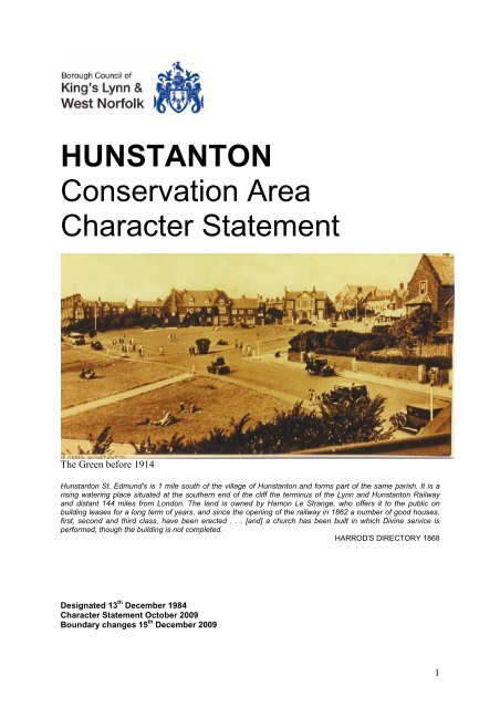
HUNSTANTONConservation AreaCharacter <strong>St</strong>atementThe Green before 1914<strong>Hunstanton</strong> <strong>St</strong>. Edmund's is 1 mile south <strong>of</strong> the village <strong>of</strong> <strong>Hunstanton</strong> and forms part <strong>of</strong> the same parish. It is arising watering place situated at the southern end <strong>of</strong> the cliff the terminus <strong>of</strong> the <strong>Lynn</strong> and <strong>Hunstanton</strong> Railwayand distant 144 miles from London. The land is owned by Hamon Le <strong>St</strong>range, who <strong>of</strong>fers it to the public onbuilding leases for a long term <strong>of</strong> years, and since the opening <strong>of</strong> the railway in 1862 a number <strong>of</strong> good houses,first, second and third class, have been erected . . . [and] a church has been built in which Divine service isperformed, though the building is not completed.HARROD'S DIRECTORY 1868Designated 13 th December 1984Character <strong>St</strong>atement October 2009Boundary changes 15 th December 20091
INTRODUCTIONA Conservation Area – “An area <strong>of</strong>special architectural or historicinterest, the character <strong>of</strong>appearance <strong>of</strong> which it is desirableto preserve or enhance”.The conservation <strong>of</strong> the historicenvironment is part <strong>of</strong> our quality <strong>of</strong>life, helping to foster economicprosperity and providing an attractiveenvironment in which to live or work.The <strong>Borough</strong> <strong>Council</strong> is committed tothe protection and enhancement <strong>of</strong><strong>West</strong> <strong>Norfolk</strong>’s historic builtenvironment and significant parts <strong>of</strong> itare designated as conservation areas.Conservation areas were introducedby the 1967 Civic Amenities Act. LocalAuthorities were required to identifyareas <strong>of</strong> special architectural orhistoric interest, whose character orappearance it is desirable to preserveor enhance, and to designate them asconservation areas. This duty is nowpart <strong>of</strong> the 1990 Planning (ListedBuildings & Conservation Areas) Actwhich also requires the review <strong>of</strong>existing conservation areas and,where appropriate, the designation <strong>of</strong>new ones. The quality and interest <strong>of</strong>a conservation area depends upon acombination <strong>of</strong> factors including therelationship and architectural quality <strong>of</strong>buildings, materials, spaces, trees andother landscape features, together withviews into and out <strong>of</strong> the area.The <strong>Hunstanton</strong> Conservation Areawas first designated in 1984 and itsboundaries were extended in 2009.This document highlights thespecial qualities which underpin thecharacter <strong>of</strong> the conservation area,justifying its designation. It alsoseeks to increase awareness <strong>of</strong> thosequalities so that where changes to theenvironment occur, they do so in asympathetic way without harm to theessential character <strong>of</strong> the area. Thistype <strong>of</strong> assessment has beenencouraged by Government Advice(PPG15) and the character statementhas been adopted by the <strong>Borough</strong><strong>Council</strong> as policy.This character statement has beenproduced with the help <strong>of</strong> <strong>Hunstanton</strong>Civic Society. It does not addressenhancement proposals. Communityled enhancement schemes will beconsidered as part <strong>of</strong> a separateprocess.SETTING AND LOCATION<strong>Hunstanton</strong> is situated on the westcoast <strong>of</strong> <strong>Norfolk</strong> at the mouth <strong>of</strong> theWash.It is an area <strong>of</strong> particular geologicalinterest, as may be seen in the cliffswhich run southwards from <strong>St</strong>Edmund's Point, just north <strong>of</strong> the town.A bed <strong>of</strong> white chalk, sloping down toeast and south lies over a thinner bed<strong>of</strong> red chalk (<strong>Hunstanton</strong> red rock) ona foundation <strong>of</strong> carstone (lowergreensand). The line <strong>of</strong> the cliffs,exposed only at <strong>Hunstanton</strong>, may beseen further south, but now as aninland escarpment, as at Snettishamand Dersingham, leaving the coastprotected only by an artificialembankment; while north-eastwards1
from Old <strong>Hunstanton</strong>, the sea is slowlyreceding as sand is deposited alongthe shore line, leaving the silted-upharbours, salt marshes and great sanddunes which characterise this stretch<strong>of</strong> the north <strong>Norfolk</strong> coast. <strong>Hunstanton</strong>stands at the highest point on thisgeological shelf and the land slopesgently downwards to north, east andsouth giving the town an exposed andbracing situation. Its cliff top settinglooking west is unlike anywhere elseon the east coast <strong>of</strong> England and thesight <strong>of</strong> the setting sun lighting up thecoloured cliffs is a unique experience.The built up area <strong>of</strong> <strong>Hunstanton</strong> lies onthe west side <strong>of</strong> the main A 149 coastroad, which, after running south tonorth parallel with the Wash, turnseastwards at <strong>Hunstanton</strong> and thenruns parallel with the north <strong>Norfolk</strong>coast. <strong>King's</strong> <strong>Lynn</strong> is sixteen miles tothe south and Wells-next-the-Seaseventeen miles to the east.Immediate neighbours are Heacham,three miles to the south, and Old<strong>Hunstanton</strong> barely a mile to the north.Part <strong>of</strong> Old <strong>Hunstanton</strong> lies within theparish <strong>of</strong> (New) <strong>Hunstanton</strong> and thetwo settlements are in fact separatedonly by the public open space at <strong>St</strong>Edmund's Point.Archaeological evidence <strong>of</strong> theprehistoric settlement <strong>of</strong> this part <strong>of</strong><strong>Norfolk</strong> includes the <strong>St</strong>one Age track,known as the Icknield Way, whichpasses through Ringstead, the BronzeAge "Seahenge" discovered at Holmenext-the-Seaand a number <strong>of</strong> IronAge finds.Evidence <strong>of</strong> a Roman settlement in thearea can be seen in the fort atBrancaster, in Peddars Way and in theroad patterns <strong>of</strong> several settlementsalong the north coast, while other localfinds point to the existence <strong>of</strong> a smallRomano-British settlement in theparish.By AD 500 there was an Anglo-Saxonsettlement at what is now called Old<strong>Hunstanton</strong>. A cemetery in thegrounds <strong>of</strong> the Hall is from this period.The name <strong>of</strong> the village derives fromOld English Hunstan's tun, meaning"Hunstan's homestead" or "Hunstan'svillage" and has changed little overtime. In Domesday Book (1086) it isreferred to as Hunestanestuna.Edmund, King <strong>of</strong> the East Angles andmartyr, is said to have landed at <strong>St</strong>Edmund's Point in 855 and built atower hereabouts.There is one main north south routethrough the town which turns <strong>of</strong>f theA149 at Lighthouse Lane, continuesalong Cliff Parade, Le <strong>St</strong>range Terraceand Southend Road and then rejoinsthe A149 via Oasis Way. Other minorroutes through the town link the A149to the Promenade on the artificial seawall which runs southwards from thecliffs at the northern end <strong>of</strong> the town.ORIGINS AND HISTORICALDEVELOPMENTThe ruins <strong>of</strong> a chapel built in hishonour in 1272 still stands near thePoint2
Shortly after the Conquest <strong>of</strong> 1066 themanor <strong>of</strong> <strong>Hunstanton</strong> was granted toRalph Fitzherluin. His daughtermarried Roland L'Estrange, who hadtaken part in the Conquest. Themanor has remained with this familyever since and it is due to the vision <strong>of</strong>a successor, Henry <strong>St</strong>yleman Le<strong>St</strong>range, that the seaside town <strong>of</strong><strong>Hunstanton</strong> was developed.In 1840 the only buildings between Old<strong>Hunstanton</strong> and Heacham were alighthouse and the ruins <strong>of</strong> <strong>St</strong>Edmund's Chapel. The land was usedfor grazing sheep. But Le <strong>St</strong>range sawthe potential <strong>of</strong> this picturesquecoastline with its white, red and browncliffs, its sandy beach and its bracingclimate; his vision was nothing lessthan a seaside resort to rival Brighton.He was a man <strong>of</strong> abundant energy andwide interests, a devout Christian, aconscientious landlord and an artistand craftsman. But he was also farsightedand shrewd: he saw that thekey to the development <strong>of</strong> the newtown was a railway connecting<strong>Hunstanton</strong> to <strong>King's</strong> <strong>Lynn</strong> and thenceto London and the Midlands. In 1861,as the principal landowner, he becamea director <strong>of</strong> the railway company andby 1862 the line had been built.<strong>Hunstanton</strong> was ready to take <strong>of</strong>fcommercially. Sadly in the same yearLe <strong>St</strong>range suffered a heart attack anddied at the age <strong>of</strong> forty seven, and itwas left to his son Hamon to reap therewards <strong>of</strong> his efforts.As a symbol <strong>of</strong> his intentions, in 1846Le <strong>St</strong>range had moved the ancientvillage cross from Old <strong>Hunstanton</strong> tothe new site and in 1848 the firstbuilding was erected.This was the Royal Hotel (now theGolden Lion), arguably the work <strong>of</strong> therenowned Victorian architect, WilliamButterfield, a friend <strong>of</strong> Le <strong>St</strong>range.Overlooking a sloping green and thesea, and for several years standingalone, it earned the nickname "Le<strong>St</strong>range's Folly". In 1850 Le <strong>St</strong>rangeappointed a land agent to survey thesite and prepare a layout, while hehimself drew and painted a map and aperspective <strong>of</strong> the scheme, showingshops, a station and a church.He did not want a conventionalscheme <strong>of</strong> streets laid out on a gridwith no open spaces, and turned toWilliam Butterfield for ideas. Theirshared passion was for the "OldEnglish" style <strong>of</strong> architecture fordomestic buildings. This owed much tomedieval precedent and to theearnestness <strong>of</strong> the Victorian GothicRevival, but, in its emphasis onmaterials, construction and informality,3
it looked forward to the subsequentArts and Crafts movement. Butterfieldlaid out the central area as a series <strong>of</strong>triangular greens with buildingsarranged "singly or in groups, inmasses <strong>of</strong> irregular form and size,interspersed with gardens and openspaces. The resort exploited fresh airand the big skies <strong>of</strong> this bracing coast.The tough, unapologetic results can beclearly seen, albeit much overlaid withmodern accretions.Development went ahead fast. In1864, Whites Directory noted that"since the coming <strong>of</strong> the railway"<strong>Hunstanton</strong> "has been rapidlyimproving "and that there are now "30commodious lodgings and boardinghouses, and 3 first class hotels", that"many villas, shops and privateresidences are in course <strong>of</strong> erection"and that "a new church is shortly to beerected near the railway station wherethe chief increase in buildings andpopulation has taken place". In 1868Harrod's Directory noted that "a gasworks is about to be established and itis in contemplation to erect a pier" andgoes on to refer to "pleasure boats andbathing machines"... "pleasantwalks"... "donkeys and ponies for hire".. . "hotels and refreshment rooms<strong>of</strong>fering excellent accommodation"...and to the "many thousands <strong>of</strong>summer visitor brought here fromdifferent parts <strong>of</strong> the kingdom by theexcursion and other trains". It liststhree schools, day and boarding, nineshops (including a "fancy emporium"),six tradesmen (including, notsurprisingly, a high proportion invarious building trades), a corn, coal,ale and wine merchant, the stationmaster, an omnibus proprietor, abuilding surveyor, a doctor and therector.The developments <strong>of</strong> the 1870s,northwards along Cliff Parade and inCliff Terrace, were quite different fromthe earlier scheme by Butterfield andcomprised a grid <strong>of</strong> streets with formalterraces <strong>of</strong> considerable opulencefacing the sea and large greensquares.In 1883, White's Directory noted thebuilding <strong>of</strong> "whole streets andterraces"; the construction <strong>of</strong> a pier bythe <strong>Hunstanton</strong> Cliff Company, whichhad also built a promenade on part <strong>of</strong>the sea wall; the completion in 1870 <strong>of</strong>the Union Chapel (unusually for thisperiod, for the use <strong>of</strong> all Nonconformistdenominations) and in 1872 <strong>of</strong> theAnglican parish church. Then in 1879came the opening by the Prince andPrincess <strong>of</strong> Wales <strong>of</strong> the ConvalescentHome, a "fine building <strong>of</strong> carstone withred brick facings and Bath stone cills".<strong>Hunstanton</strong> was booming.From 1892 the town was governed bya Local Board until the establishment<strong>of</strong> the separate parish and UrbanDistrict <strong>Council</strong> <strong>of</strong> New <strong>Hunstanton</strong>under the Local Government Act <strong>of</strong>1894. In 1896 the fine Town Hall,designed by George Skipper, wasbuilt. It stands, fittingly, next door tothe Golden Lion - now no longerisolated but at the heart <strong>of</strong> a thrivingresort.The meteoric rise <strong>of</strong> <strong>Hunstanton</strong> andthe continuing development <strong>of</strong>residential areas north and south <strong>of</strong>the already established centre were4
accompanied by an increase in thefacilities available to residents andvisitors. In 1891 the golf links, in 1895the Methodist Chapel in Austin <strong>St</strong>reet,in 1904 The Roman Catholic church inSandringham Road, the RecreationGround and the establishment <strong>of</strong> clubsfor sports <strong>of</strong> all kinds. Between 1924and 1932 came the extensionsouthwards <strong>of</strong> the sea wall and thecreation <strong>of</strong> a swimming pool, a boatinglake, gardens and shelters, in 1937 thebowling greens and a pavilion in theEsplanade Gardens.Between 1950 and 1954 SmithdonHigh School was built east <strong>of</strong> thepresent A149, to designs by Alisonand Peter Smithson. This building,with its innovative steelwork, is listedgrade II* though it is outside theconservation area.In 1969 the closure <strong>of</strong> the railway line,which had been so instrumental in thedevelopment <strong>of</strong> the town over theprevious century, heralded a new era.The station and the SandringhamHotel south <strong>of</strong> The Green weredemolished, to be replaced by ashopping centre and flats at HarlequinHouse, while land to the south, on theline <strong>of</strong> the former railway, was givenover to extensive areas <strong>of</strong> parking toaccommodate the fast growing number<strong>of</strong> visitors arriving by car. At the sametime, the public's increasingpreference for foreign holidaysdemanded a response from traditionalEnglish seaside resorts. Extensivelow-price leisure facilities under coveragainst the weather seemed to be theanswer: thus the pre-war outdoorfamily attractions on South Promenadewere, in the 1980s, replaced by thepresent Oasis Leisure Centre and theSea Life Centre, while other seasideattractions were updated or replaced.The pierhead pavilion was destroyedby fire in 1939 and later replaced bythe present amusement arcade, whilein 1978 the pier itself was destroyed ina storm.Changing public habits and tastes andeconomic changes have caused thenumber <strong>of</strong> boarding houses and hotelsto decline and a corresponding growthin the provision <strong>of</strong> holiday flats,whether by conversion <strong>of</strong> olderproperties or building anew. Elsewherethe growing number <strong>of</strong> elderly peoplein the community has encouraged theconversion <strong>of</strong> large houses intoresidential homes. The emphasis oncost in an ever -changing market hasmeant that many new developmentshave sacrificed much <strong>of</strong> the qualityassociated with the town's Victorianheyday. But some traditions havesurvived all the changes. The quality<strong>of</strong> the maintenance <strong>of</strong> the EsplanadeGardens shows the tradition <strong>of</strong> publicgardening bequeathed by theVictorians to be as strong as it hasever been, while the recently createdSensory Garden in Boston Square isan entirely new and imaginative <strong>of</strong>fshoot<strong>of</strong> that tradition.Census figures, for what was still until1894 one parish, reflect the dramaticexpansion <strong>of</strong> the new town. In 1851and 1861 the population stood at 490.By 1871 it had risen to 810 and by1881 to 1,508. It was not until 1901that separate figures for the twoparishes are available. These show5
that the population <strong>of</strong> the old village, at508, was back to much as it had beenin the middle years <strong>of</strong> the previouscentury, while the new town, now onits own, had jumped to 1,893. In 1928parts <strong>of</strong> the parishes <strong>of</strong> Old<strong>Hunstanton</strong> and Heacham weretransferred to New <strong>Hunstanton</strong>, againmaking it hard to compare like withlike. In 1931 the population <strong>of</strong> the nowenlarged area <strong>of</strong> New <strong>Hunstanton</strong>stood at 2,627. The estimated figurefor the parish in 2007 is 4,716.So, <strong>Hunstanton</strong> is a planned seasidetown, founded by a remarkable man,Henry <strong>St</strong>yleman Le <strong>St</strong>range, and builton his own land. It possesses styleand character – its main buildings aresubstantial but not over grand; itssquares and open spaces are elegantyet informal. It is a comfortable,modest place, small in architecturalscale with well-defined boundaries. Itscharacter is spacious, breezy andgreen, where the effect <strong>of</strong> the opensea and sky has a strong impact onthe light, views and settings <strong>of</strong> thebuildings.CHARACTER OVERVIEWFor convenience the ConservationArea can be divided into five separateareas, according to the dominantcharacter <strong>of</strong> each. These comprise:The Town Centre, The Cliffs andSquares to the north, East <strong>Hunstanton</strong>which adjoins the centre, The Avenuesto the north east and South<strong>Hunstanton</strong>.THE TOWN CENTREThis includes the earliest developmentin <strong>Hunstanton</strong> dating from the 1860s,much <strong>of</strong> it now being the commercialcore <strong>of</strong> the town. The area includesseveral important public buildings anda number <strong>of</strong> open spaces.The deliberately informal layout wasthe work <strong>of</strong> William Butterfield andcomprised buildings "singly and ingroups, in masses <strong>of</strong> irregular formand size, interspersed with gardensand open spaces". However, theexpansion <strong>of</strong> the commercial core intoareas originally designed forresidential use has led to much visualconfusion. Or perhaps one could saythat those who planned the new townfailed to design sufficiently for shops.The ‘centre’ includes The Green withthe Town Hall, the Golden Lion Hoteland the flats at Cliff Court, <strong>St</strong>Edmund's Church, Le <strong>St</strong>rangeTerrace, <strong>St</strong> Edmund's Terrace, theHigh <strong>St</strong>reet, most <strong>of</strong> Greevegate andmost <strong>of</strong> <strong>West</strong>gate.The GreenMost seaside resorts are laid outparallel to the coast line. <strong>Hunstanton</strong> isdifferent. Here the triangular Greensets the pattern for the earliestdevelopment. The major streets rundown to the sea and the lesser streets(including the short High <strong>St</strong>reet) crossalong the contours <strong>of</strong> the slope.The first building <strong>of</strong> the new town wasto be a hotel overlooking the seaacross a large sloping green, and thisarea remains the natural hub <strong>of</strong> the6
town, linking the commercial area(centred on the High <strong>St</strong>reet) to theleisure area running parallel to theshore line (northwards in theEsplanade Gardens and southwardsalong Le <strong>St</strong>range Terrace and SouthPromenade). The Golden Lion Hotelstill dominates the Green, although itnow shares pride <strong>of</strong> place with theadjoining Town Hall. The medievalcross in front <strong>of</strong> the hotel remains afocal point in the space, which hashappily retained its natural open view,without the interruption <strong>of</strong> trees orother features. Red-brown tarmacpaths harmonise with the localmaterials used in retaining walls.Traditional cast iron "serpent" seats, amodern bandstand <strong>of</strong> traditional formand a hipped ro<strong>of</strong>ed toilet block allmake a positive contribution to thescene. Happily, the fountain has beenre-erected on The Green.At the far north end an imaginativelydesigned curved seating area doublesas the ro<strong>of</strong> <strong>of</strong> beach huts below.Regrettably, on the south side, theharsh appearance <strong>of</strong> Harlequin House(just outside the conservation area)detracts with its form, design, colour <strong>of</strong>brick and unfortunate ‘mansard’ styleto disguise a flat ro<strong>of</strong>.On the south east side, facing thesea, number 21 (Cassie's) is a fineVictorian building <strong>of</strong> carstone with atimber balcony, but the adjoiningGreen Lodge, has been spoilt by a flatro<strong>of</strong>ed front extension. Facing TheGreen, a three storey carstone terrace,probably designed by WilliamButterfield, with his favourite mix <strong>of</strong>hipped and gabled dormers. Theconcept had been diluted by a variety<strong>of</strong> front extensions in a bid to maximisethe value <strong>of</strong> this prime commercial site.The use <strong>of</strong> ribbed concrete pantiles inplace <strong>of</strong> the original slate, the removal<strong>of</strong> chimneys and inappropriate windowreplacements have down-graded theoriginal design. On the end <strong>of</strong> thisterrace and on the corner <strong>of</strong> <strong>St</strong>Edmund's Terrace, the PrincessTheatre is a strange building, its heavydetails and small corner windows lendit an almost "defensive" character.However, the use <strong>of</strong> carstone helps itblend with its surroundings and therecent entrance extension,incorporating a glazed ro<strong>of</strong>, seemsrather more compatible with anenjoyable evening out. On theopposite corner <strong>of</strong> <strong>St</strong> Edmund'sTerrace, an opportunity has beenmissed to develop the site in a creativeway. Instead, a modern building inbrick has sought unsuccessfully tocopy features <strong>of</strong> older buildingsalongside, even to the extent <strong>of</strong>designed-in front extensions. Thecorner into Greevegate has anotherfront extension (albeit <strong>of</strong> some qualityin itself), but the appearance is marredby the removal <strong>of</strong> an importantchimney and the use <strong>of</strong> unsympatheticro<strong>of</strong> tiles.On the north-east side, The GoldenLion and the Town Hall (both listedbuildings) are very different in style,but they are united in the materials <strong>of</strong>which they are built: carstone,limestone and red pintiles. Cliff Court,north <strong>of</strong> the hotel, with its staggeredplan, boxy forms and flat ro<strong>of</strong>s,intrudes and jars with surrounding7
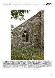
older buildings and the landscaping isdisappointing.Greevegate(from The Green to Church <strong>St</strong>reet)From Greevegate there is a fine viewlooking down hill across The Green tothe sea.The north side <strong>of</strong> the street beginswith the lively and varied side elevation<strong>of</strong> the Town Hall. In front is anattractive small green space with atree, followed by a flat ro<strong>of</strong> protectedby barbed wire. Then, on the cornerwith Northgate, a modern two storeyshopping development, with astaggered layout and assertive flatro<strong>of</strong>s, bears no relationship withsurrounding street lines or ro<strong>of</strong> lines.Its design is poor and it lacks quality.The opposite corner is firmly "held" bythe early twentieth century classicalstyle Nat <strong>West</strong> Bank. <strong>St</strong> Edmund'sChurch <strong>of</strong> 1872 (a listed building) is setback behind an attractive small greenon the corner with Church <strong>St</strong>reet. Themix <strong>of</strong> flint, red chalk and carstonegives an unexpected liveliness to thesouth aisle. Though one was plannedby Le <strong>St</strong>range, a tower was never built:it would have given the church more <strong>of</strong>a presence in the town.On the south side <strong>of</strong> Greevegate, ashort carstone terrace with simplegables, originally designed forresidential use, is now all but lostbehind a varied collection <strong>of</strong> shopfronts extended out to the pavementover former front gardens. Thisextends to the corner with the High<strong>St</strong>reet. In contrast, on the oppositecorner Barclay's Bank <strong>of</strong> 1872 wasclearly designed for its presentpurpose. It turns the corner with anelaborate gable and a fine Gothic styleporch. Elaborate ground floor baywindows on both fronts, cast ironbalconies, large upper windows instone frames keyed into the randomcarstone walling complete this finebuilding. The same style is continuedup the street, though here it has beencompromised by an unsympatheticshop front and the loss <strong>of</strong> a balcony.From here a modest two storey terracewith first floor dormers, extending tothe corner with Church <strong>St</strong>reet, hasbeen overwhelmed by shop fronts andwindow replacements.<strong>St</strong> Edmund’s TerraceThere is a good view looking northalong <strong>St</strong> Edmund's Terrace towardsThe Green, the Town Hall and theGolden Lion.A terrace <strong>of</strong> three storeys andbasement stretches almost the wholelength <strong>of</strong> the east side <strong>of</strong> the street.By William Butterfield, its materials anddetails are similar to those <strong>of</strong> theterrace facing The Green (see above):random squared carstone, a mix <strong>of</strong>hipped and gabled dormers, relievingarches over openings. Here however,because it is the basements whichhave become commercial premises,the "ground floor" front doors havesurvived, together with their shallowGothic canopies. Paved over formerfront gardens are used for open aireating or for displaying goods. Only atNo 2 has a large ungainly lean-towrap-round extension been built.8
Upper floors have their usual quota <strong>of</strong>unsympathetic window replacements.One <strong>of</strong> Butterfield's triangular greensmarks the junction with <strong>West</strong>gate.Known as The Spinney, it is plantedwith trees and adds much to theattraction <strong>of</strong> this area.Around its edge are redundantconcrete bollards which detract fromits charm and the expanses <strong>of</strong> tarmacroads, which surround the green, alsodetract from what could be a pleasant,pedestrian-friendly public space.On the west, the side <strong>of</strong> the PrincessTheatre (see above) dominates thenorth end <strong>of</strong> the street. From this angleit appears as essentially a large shed,out <strong>of</strong> scale with its surroundings, butits expressed frame structure infilledwith panels <strong>of</strong> carstone gives it astrong local character. Its dominancein the street scene is accentuated bythe derelict site which adjoins it andbeyond that, the poorly designed busstation with its vast expanse <strong>of</strong> tarmaccompletes the visual disaster.Redevelopment here would need torespect the Butterfield Terrace acrossthe road, provide a visual complementto the theatre and enhance the setting<strong>of</strong> The Spinney. The small car parkbehind is enhanced by trees round itsedge.<strong>West</strong>gateThe street follows the north-east tosouth-west slope <strong>of</strong> the land and, indoing so, describes a two angledbend: one at the junction with the High<strong>St</strong>reet, the other between Nos 24 and28. This allows buildings to be seenfrom different angles. Trees areimportant in the street. They are seenin The Spinney at the junction with Le<strong>St</strong>range Terrace, in the large garden <strong>of</strong>No 3, and, further up the hill, in thegrounds <strong>of</strong> the <strong>Council</strong> <strong>of</strong>fices.Surviving front garden walls areimportant.On the ‘south’ side numbers 2 to 24comprise two fine terraces <strong>of</strong> carstonehouses. <strong>St</strong>epped up the hill, the lowerterrace has attic dormers and twostorey bays (replaced in timber, to itsdetriment, mid terrace), the higherterrace is generally simpler thoughenriched with black and white tiles butit is spoilt by fascias to ground floorshop conversions. Nos 28 to 30 are agrand pair <strong>of</strong> typical large Victoriansemi-detached houses with stone baysto two floors and gables. Nos 32 and34 are, unusually for <strong>Hunstanton</strong>, apair <strong>of</strong> semidetached houses in aclassical style, disrupted at number 34by a shop front.9
Union Church, an attractive building ingothic style <strong>of</strong> carstone and limestonewith timber windows, presents a threesided apse to the street (opposite thebus station), enriched with bands interracotta and brick and stone dressedbuttresses. Similar details may beseen on the side elevations. Concretepaths, a lack <strong>of</strong> trees and thereplacement <strong>of</strong> part <strong>of</strong> the carstoneboundary wall in an unsympatheticbrick make the setting <strong>of</strong> the churchsomewhat bleak and especially whenviewed across the bus station from <strong>St</strong>Edmund’s Terrace. Moving uphill fromthe church, numbers 40 to 46 make upanother terrace, probably byButterfield, with hipped and gableddormers. Shop front extensions,though detracting form the originaldesign, are, happily, not continuous,but the removal <strong>of</strong> chimneys isparticularly noticeable and the use <strong>of</strong> aweaker" material (brick) as a newretaining plinth to an older building <strong>of</strong> a"stronger" material (carstone) isunfortunate. The original frontboundary wall remains at No 42.Number 52-54 is unusual in being asingle house with asymmetric gables.Its quite unrelated extension - anEdwardian shop front with deep baywindows above - is, in itself, attractiveand makes a positive contribution tothe street scene. Numbers 56 to 70are dominated by shop frontextensions and (62 to 68 only) firstfloor bays. A modern building andSainsbury’s supermarket take up most<strong>of</strong> the block between Homefields Roadand Valentine Road. The use <strong>of</strong> abrown brick, not far <strong>of</strong>f the colour <strong>of</strong>carstone, and <strong>of</strong> giant pilasters andarches, goes some way to fit thisessentially modern building type into atraditional street, in terms <strong>of</strong> form andscale. But the two end blocks are onlybarely related to each other and theeaves look clumsy. No 94 survivesisolated at the corner <strong>of</strong> ValentineRoad, its appearance enhanced with awell designed new shop front andrailings around the corner.On the ‘north’ side, number 3 is asubstantial house in large grounds withtrees and boundary walls. It could bein a village rather than in the towncentre. Its contribution to the character<strong>of</strong> this part <strong>of</strong> <strong>Hunstanton</strong> cannot beover-emphasised: it is important thatsuch "lungs" are retained. Its treesserve to link those in the upper andlower triangles. The Public Libraryenjoys a backdrop <strong>of</strong> trees and helpsto screen the bus station behind.However the attached cafe andbusiness premises, single storey andflat ro<strong>of</strong>ed, does nothing for an areaalready blighted by the "sea <strong>of</strong> tarmac"at the entrance to the bus station andby the derelict former garage forecourtto the north (see above). Between <strong>St</strong>Edmund's Terrace and the High <strong>St</strong>reetthe frontage is very broken up, with theend <strong>of</strong> the terrace, back yards and aservice lane. This has recently beenenlivened by the appearance <strong>of</strong>outside tables to the café which formspart <strong>of</strong> the shop which turns the cornerinto the High <strong>St</strong>reet... Numbers 63 - 65are single storey, flat ro<strong>of</strong>ed and <strong>of</strong> novisual importance. Numbers 69 and 71have a heavy shop front extension andhave lost chimneys. Number 73survives as a traditional corner shopwith a fine shop front, whilst number75 has an attractive new shopfront10
accommodating a tea room. Furtheralong, two storey terraced anddetached houses are overwhelmed byshop front extensions.High <strong>St</strong>reetThe High <strong>St</strong>reet is the principalshopping street. It contains a jumble <strong>of</strong>buildings <strong>of</strong> different heights andtypes. They are mostly late Victorian,but two are substantial post-warstructures, designed as shops.Inevitably these two bear no relation tothe older buildings in the street, whichare many cases domestic in origin andscale. The view north is stopped by theassertive staggered flat ro<strong>of</strong>s <strong>of</strong> themodern Northgate shops (see above).There is a lack <strong>of</strong> harmony,emphasised by the mix <strong>of</strong> shop fronts,some <strong>of</strong> which detract and diminish thequality <strong>of</strong> the street scene...On the east side, The Corner Caféand bakers, a modest two storeybuilding, has a traditional mouldedfascia, extending over an "arcade" withcast iron columns which, even thoughit has little relationship with the buildingabove, is an attractive feature in itself.Next to it, on a quite different scale,two modern buildings areundistinguished and typical <strong>of</strong> the lowquality <strong>of</strong> commercial design <strong>of</strong> theirtime. They clash with each other inmaterials, window proportions andeven in ro<strong>of</strong> line. The formerWoolworth’s store is tawdry inappearance. Number 24 iscommercial in origin: <strong>of</strong> three storeysand well proportioned, with apediment-like gable to the street andan equally important long sideelevation. Window replacements to theupper floors and the shop front detract.Numbers 26 and 28 are similarly <strong>of</strong>three storeys, but with the top floor asan attic with dormers cutting theeaves. The consequent rain waterplumbing dominates the facade aboveindifferent shop fronts. Numbers 30 to36 appear to be the remnant <strong>of</strong> anearlier two storey development, somewith upper bay windows. The use <strong>of</strong>large squared carstone gives numbers34 and 36 a markedly local, ruralflavour. Number 40 is again three fullstoreys high, in scale with Barclay'sBank on the corner (see above), butsadly marred by a poor shop fasciaand a plastic projecting fascia boxsign.On the west side, numbers 1 to 9 areplain two storey buildings with shopfront extensions. Numbers 11 to 17 area mixture <strong>of</strong> two and three storeys,with typical late Victorian bay windowsor dormers cutting the eaves and ajumble <strong>of</strong> shop fronts unrelated to whatis above. The frontage then peters outalmost completely, with numbers 21 to25 (a mixture <strong>of</strong> flat ro<strong>of</strong>ed extensionsengulfing a small house), number 27(in effect a shop front filling a backyard) and a rear view <strong>of</strong> buildings inGreevegate.Northgate11
The west side is taken up by amodern development <strong>of</strong> staggeredshops with flat ro<strong>of</strong>s (see above). Thechange in level between their forecourtand the street is marked only byunattractive railings. The view is bleakand cheap.The original entrance to the church onthe east side was by the west doorfacing Northgate. South <strong>of</strong> the church,numbers 3 and 4 Church Close arepart <strong>of</strong> a group <strong>of</strong> bungalows for theelderly. Its concept is pleasing thoughits design hardly rises to the challenge<strong>of</strong> this important site. Numbers 2 and 4Northgate, <strong>of</strong> carstone and withdormers, are a relic <strong>of</strong> earlierdevelopment, in contrast to the cornerbank (see above), they have beenmuch altered by shop front insertions.Le <strong>St</strong>range TerraceThis short street, like The Green, isessentially part <strong>of</strong> the leisure quarter.On its east side, a footpath leadsdown from the car park by the busstation to Le <strong>St</strong>range Terrace, pastnumber 23 The Green (an attractiveresidential conversion) to emergebeside Bank House. This is a solidlooking carstone house with relievingarches over windows and classicaldetails surviving in the central doorwayand in part <strong>of</strong> a shop front. But it hasbeen spoilt by modern shop fronts,plastic windows and the removal <strong>of</strong>chimneys. Numbers 16 to 20 are anamusement arcade... Number 14 is anodd little carstone building with aterracotta window in a gable facing thestreet. Numbers 10 to 12 is the Washand Tope Hotel, with a pleasing simplefacade somewhat compromised bywindow replacements. Numbers 2 to 8is a terrace, <strong>of</strong> which number 2 onlyretains an attractive front <strong>of</strong>surprisingly varied carstone.The conservation area has beenextended on the west side <strong>of</strong> the roadto include the pleasant ‘Art-Deco’ styleshops (nos 1 to 5) and the ‘Coal Shed’gallery behind. This little building is asurvivor <strong>of</strong> the railway complex – acoal depot <strong>of</strong>fice which stood in thestation yard.THE CLIFFS and SQUARESThis area is entirely residential. Itcomprises the slightly laterdevelopment <strong>of</strong> the land immediatelynorth <strong>of</strong> the town centre with its grand,formal layout and its large houses,which include the fine terraces alongCliff Parade and along the north side<strong>of</strong> Cliff Terrace. A variety <strong>of</strong> spaciousdevelopments, spanning over severaldecades, are sited around the largeformal squares <strong>of</strong> Boston and Lincolnand along the east side <strong>of</strong> Northgate.The Arts and Crafts style, from the turn<strong>of</strong> the nineteenth and twentiethcenturies, particularly the fine work byH.G. Ibberson, is represented in thisarea. It boasts three substantial publicopen spaces, the gardens <strong>of</strong> the twosquares, and the Esplanade Gardens.12
Cliff ParadeThe Esplanade Gardens areeverything that traditional seasideresort gardens should be. They aremuch used, but grass, paths and welldesigned planting remain carefullytended, while all the "furniture" looksjust right. Bowls, putting and children'splay are all catered for. At the southernend the War Memorial (a miniCenotaph) is surrounded by colourfulbedding plants. Attractive smallbuildings include the restaurant(pyramid ro<strong>of</strong>), the toilets (half hippedro<strong>of</strong>) and the attendant's hut (withloggia). The flat ro<strong>of</strong> <strong>of</strong> the refreshmentkiosk is a pity. The design <strong>of</strong> theroadside railings is unusual andinteresting.On the east side <strong>of</strong> Cliff Parade, thetall buildings have bay windowsframed in painted stonework, keyedinto the carstone. The layout and thecontinuous cast iron balconies may bereminiscent <strong>of</strong> the Regency, but thebuilding style is solidly "Old English",even to the gothic doorways.Enormous chimneys survive, but inmany instances concrete tiles havereplaced slates. The northern terraceis similar in materials but, instead <strong>of</strong>the gabled skyline, it has a continuousrow <strong>of</strong> small dormers culminating ateach end, in the French style, with amansard ro<strong>of</strong>ed pavilion and a pointedro<strong>of</strong>ed corner turret or ‘belvedere’. Inthis terrace some ro<strong>of</strong>s have beenunsympathetically renewed in concretetiles, some steps have been rebuilt inconcrete and front gardens have beentarmaced over and separated byunattractive dwarf walls.The conservation area has beenextended along Cliff Parade to includethe green from the sea wall to the roadand from (and including) the pierreplacement building up to thelighthouse and the buildings around it.Also included are the formercoastguard cottages and thecoastguard look-out building <strong>of</strong> around1910 and the northern promenade.When <strong>Hunstanton</strong> started to be built inthe 1850s, green spaces were animportant part <strong>of</strong> the concept. Thearrival <strong>of</strong> the railway in the 1860sbrought day-trippers who were able toparade from the station across thegreen and along the cliff top to thelighthouse. This open space, whichfollows on from the present EsplanadeGardens, still remains, despite coastalerosion, with its three handsomeshelters.13
and garage court only further erodesthe street frontage. The use <strong>of</strong> "crazy"concrete paving on the small island atthe junction with Cliff Parade gives it abarren character, at odds with thegardens opposite.The southernmost <strong>of</strong> these was built in1898 as a memorial to Francis Hewitt<strong>of</strong> Leicester and bears a plaque to thateffect. The middle shelter is at risk andwill need re-locating soon; the northernand southern shelters are lessaffected.This strip <strong>of</strong> land, now boarded on theeast by modern seaside housing, isincluded in the conservation area. It ispart <strong>of</strong> the original resort and alsoprovides the visual extension toLincoln Square.Cliff TerraceCliff Terrace (1873) is exactly alignedon the axis <strong>of</strong> the church. There is afine view <strong>of</strong> the church looking up thestreet, although it is rather obscured bytrees.On its north side, the terrace turns thecorner and then sets back, to befollowed by a further terrace, steppingup the hill, in similar style but withoutan attic. This frames the church andleads the eye up to it, but on one sideonly.Boston SquareThe gardens have recently been laidout as a Sensory Garden, with flair andimagination. Features include a poolwith a fountain, walls <strong>of</strong> loose flints incages, screens and seats, pergolasand decking, varied textures and "dry"planting.On the south side <strong>of</strong> the square,Connaught House turns the corner <strong>of</strong>the terrace on Cliff Parade. Numbers6, 8 and 10 are good examples <strong>of</strong> theArts and Crafts style <strong>of</strong> the turn <strong>of</strong> thenineteenth and twentieth centuries: agood period for English domesticarchitecture.In contrast, the south side is a visualdisaster with poor architecture. CliffCourt is at one end and the backs <strong>of</strong>the staggered shops at the other (forboth see above). In between a service14
3 to 9, <strong>of</strong> carstone with bays extendingup as parapet dormers, are aninteresting group in a mildly Arts andCrafts style. The introduction <strong>of</strong> plasticwindows though carried out fairlysensitively, strikes a discordant note,particularly when "pseudo-sashes" areopen. There are surviving carstonefront garden walls.They are by H. G. Ibberson, a Londonarchitect, who built a number <strong>of</strong>houses in <strong>Hunstanton</strong> with a distinctivestyle.The terrace on Cliff Parade turns thecorner on the north side. Numbers 5and 7 are particularly fine Arts andCrafts style,Lincoln SquareThe square looks onto a pleasantgrassed area surrounded by trees,which do battle with the strongprevailing wind.On the south side, the terrace on CliffParade turns the corner in style, but isthen extended in a clumsy and dullfashion. This is followed by two pairs<strong>of</strong> modern low rise flats, with jaggedmonopitch ro<strong>of</strong>s, which visually donothing for this prime site. Number 8(with number 35 Northgate) are a pair<strong>of</strong> turn <strong>of</strong> the century houses in an Artsand Crafts style.On the north side, <strong>West</strong>cliffe Court ispart <strong>of</strong> a larger modern development <strong>of</strong>flats which continues round the corneralong Cliff Parade. Its scale, thoughright for the Parade, is too high for theSquare and its horizontal lines and flatro<strong>of</strong>, disguised by a "mansard", strikea discordant note beside the olderParade terraces to the south. NumbersNorthgateNorthgate is a major north-south routeparallel to Cliff Parade to the west andthe main Cromer Road to the east.Northgate forms the eastern end <strong>of</strong>both Boston and Lincoln Squares. Itswest side is therefore largely made up<strong>of</strong> either side elevations <strong>of</strong> housesfacing the square and entries to backlanes. Larch lap fencing isinappropriate here. The rear wing <strong>of</strong>No 9 Boston Square has an Arts andCrafts circular turret with bands <strong>of</strong>carstone and chequerboard carstoneand flint balanced by a horizontal band<strong>of</strong> windows (motifs <strong>of</strong> the architect H.G. Ibberson). No 47 is a small Arts andCrafts style cottage.On the east side, a typical large-scalebay-windowed Victorian terraceincludes the Vicarage (number 10)with a nice onion-domed corner turret.It has an Arts and Crafts styleextension towards the church withblind arcading in carstone and a crossin the gable joining first floor and atticwindows. Number 24 (with number 28Austin <strong>St</strong>reet) is a superb Arts andCrafts style building <strong>of</strong> randomcarstone with huge overhangingdormers above shallow rendered baywindows in the manner <strong>of</strong> Voysey. Ithas an Art Nouveau lead sundial on achimney (probably originally higher)bearing the text It is better to havetraveled hopefully than to arrive.15
It was the architect H G Ibberson’shouse. Numbers 30, 32 and 34together with 2 Lower Lincoln <strong>St</strong>reetare two pairs <strong>of</strong> imposing semidetachedhouses in the Queen Annestyle with mansard ro<strong>of</strong>s and talldormers. Number 2 has a terracottaplaque inscribed 1898. Larch-lapfencing on the Lower Lincoln <strong>St</strong>reetfrontage looks out <strong>of</strong> place. Number36, a large carstone house with gablesand dormers has been converted t<strong>of</strong>lats. This has involved an extensionon the corner with Lower Lincoln<strong>St</strong>reet, while five further houses insimilar style <strong>of</strong> one or two storeys andattics complete the side streetfrontage. Forms and materials aregenerally in sympathy with the originalbuilding, although windowreplacements in the old house arevisually <strong>of</strong> lesser "weight" than theoriginals. Numbers 38 to 50 aresubstantial typical late Victorianhouses, detached or semi-detached:half-timbered gables reflect thegrowing interest in vernaculartraditions, though the use <strong>of</strong> hard redbrick combined with carstone is solidlyVictorian.EAST HUNSTANTONThis is a small area immediately east<strong>of</strong> the Town Centre It includes, inValentine Road, the formerConvalescent Home (now flats) andthe former Children's ConvalescentHome (now council <strong>of</strong>fices), the mainlyresidential development <strong>of</strong> smallterraced houses in Church <strong>St</strong>reet andJames <strong>St</strong>reet and the more spaciousresidential development <strong>of</strong> the easternend <strong>of</strong> Greevegate. Most <strong>of</strong> this areaappears to date from much the sameperiod as the ‘Cliffs & Greens’ area;i.e. the 1870s or 1880s. The streetpattern is a regular grid, but the flatsand the council <strong>of</strong>fices are built at anangle within the grid. The council<strong>of</strong>fices stand in substantial grounds,most <strong>of</strong> it devoted to car parking, butthe grounds <strong>of</strong> the formerconvalescent home have now beendeveloped.GreevegateThe eastern end <strong>of</strong> Greevegate isentirely residential and has retainedthe air <strong>of</strong> a prosperous Victoriansuburb. Some original stone walls andrailings have been lost and some havebeen replaced in brick or concreteblock. Many windows havereplacement plastic, though in mostcases, they are back from the wall faceand have imitated the pattern <strong>of</strong>glazing bars. This reduces theirimpact.On the north side, number 33,covered in creeper, has an important16
position on the corner opposite thechurch. Numbers 35 to 53 are pairs <strong>of</strong>very grand semi-detached houses, <strong>of</strong>carstone with painted stone dressings,in the "Old English" style. Typical arenumbers 43-45 with two storey baywindows with pierced stone parapetsand paired windows above,surmounted by gables with trefoilopenings. Number 45 has its originalwindows and an attractive side orielwindow. The carstone <strong>of</strong> one hasunfortunately been painted over andanother shows the effect <strong>of</strong> newwindows being placed too far forward.Numbers 38-40 on the south side aresimilar in style to those on the northside, but with ornate cast iron crestingto bay parapets. Number 40, which is"double fronted", has retained originalwindows. Numbers 42 to 46 have redbrick dressings, decorative terra cottapanel and curved lead ro<strong>of</strong>s with ironcresting to bays. Numbers 54 to 58 aretwo storey with attics and gables, in avery rural style.Valentine RoadFrom Greevegate to <strong>West</strong>gate (on itseast side), Valentine Road isdominated by two buildings whichhave played a unique role in the shorthistory <strong>of</strong> <strong>Hunstanton</strong>. Bothconvalescent homes, the northernmost<strong>of</strong> the two for adults was completed in1874, the southern one for children, in1907. Though on square sites in aregular street grid, both are placeddiagonally, so as to face south-west,presumably to maximise "green" viewsfrom the wards. The first has beenconverted to flats and much <strong>of</strong> thegrounds built over with houses. The1874 building, <strong>of</strong> carstone red brickand slate, is rather sombre but isrelieved by gables with white paintedtimber details and attractive whitepainted porches. The removal <strong>of</strong> allchimneys detracts very considerablyfrom its appearance. The loss <strong>of</strong> openspace and trees and the introduction <strong>of</strong>large areas <strong>of</strong> tarmac are regrettable,but the design <strong>of</strong> the new houses, inkeeping with that <strong>of</strong> the originalbuilding, is exemplary. The 1907building, converted to localgovernment <strong>of</strong>fices, is a typicalinstitutional building <strong>of</strong> its time:formally symmetrical but with an Artsand Crafts flavour. It is more attractivethan its older neighbour. Limestonebays and bands relieve the carstone,brick and slate; chimneys survive andthe ro<strong>of</strong> is crowned by an ornateventilator. Trees and some grass havesurvived the change <strong>of</strong> use. A smallmodern health centre fits in happily ina corner <strong>of</strong> the grounds.On the west side, the most importantbuilding is the school on the corner <strong>of</strong>James <strong>St</strong>reet. It is a typical latenineteenth century board school,though the use <strong>of</strong> carstone gives it amore local, vernacular appearance. Amaster's house is attached at one end.<strong>St</strong>one mullioned windows give a nod tothe "Old English" style. The originalstone boundary walls survive.Numbers 1-3 are similar to houses inJames <strong>St</strong>reet, while numbers 9-11form an attractive pair <strong>of</strong> smallcottages next to the school.Church <strong>St</strong>reetThis is for the most part a quietresidential street, with walled frontgardens. The houses are mostly small,<strong>of</strong> two storeys and terraced, some withattic dormers, some with bay windows.Many windows have been replacedwith plastic, though in most cases anattempt has been made to keep insome sympathy with the originals.Many slate ro<strong>of</strong>s have been replacedwith concrete tiles. Chimneys aregenerally intact. North <strong>of</strong> the junctionwith James <strong>St</strong>reet the street risesgently to Greevegate and then levels17
out past the church.Built <strong>of</strong> carstone, most <strong>of</strong> the houseson the east side are <strong>of</strong> modest scaleand could be described as cottages.Numbers 40 to 50 are built hard up tothe pavement. Numbers 40 and 42,which share a gable end facing thestreet, are unusual. Number 68, at theend <strong>of</strong> the terrace north <strong>of</strong> the church,has been drastically altered and sobreaks the unity <strong>of</strong> the terrace.The Witley Press takes up most <strong>of</strong> thefrontage from James <strong>St</strong>reet toGreevegate on the west side. It hasthree sections: an interesting earlytwentieth century framed building witha wide-span curved ro<strong>of</strong>, an oldersmall building with its gable to thestreet and a dull flat ro<strong>of</strong>ed building <strong>of</strong>the 1950s.James <strong>St</strong>reetOn the north side, numbers 1 to 7 aresmall carstone terraced houses buttheir bays have pierced parapets likethose in more up-market Greevegate(see below). No original windowssurvive. The south side is taken up bythe school (see above).East <strong>of</strong> Valentine Road, the street isunmade. On the north side attractivepine trees from the formerconvalescent home grounds survive inthe back gardens <strong>of</strong> the new houses.On the south side are the health centre(see above) and the hedge and trees<strong>of</strong> the <strong>Council</strong> <strong>of</strong>fices.<strong>West</strong>gate (east <strong>of</strong> Valentine Road)The trees in the grounds <strong>of</strong> the <strong>Council</strong><strong>of</strong>fices are a significant elementlooking east up <strong>West</strong>gate pastSainsbury’s supermarket. On the southside, numbers 96-98 (Tabor House)are an original pair <strong>of</strong> houses <strong>of</strong>carstone and brick now in commercialuse. A flat ro<strong>of</strong>ed modern cornerextension in matching materials linkssuccessfully to an older barn-likecarstone building on Valentine Road(outside the Conservation Area).Number 98 is linked to Swain's, a largemodern <strong>of</strong>fice building, <strong>of</strong> two storeysand attic, set back from the roadbehind parking This in turn is linked tonumber 6 <strong>King's</strong> <strong>Lynn</strong> Road, an Artsand Crafts style house with pebbledash render and exaggerated carstonequoins.Kings <strong>Lynn</strong> Road (from Greevegateto <strong>West</strong>gate)On the east side stone walls and piersmark the entrance to the RecreationGround while trees on the vergeprovide an attractive edge. On thewest side an important wall marks theboundary <strong>of</strong> the former convalescenthome.THE AVENUESThis area extends north-eastwardsfrom <strong>St</strong> Edmund's Church and appearsto date from around the turn <strong>of</strong> thenineteenth and twentieth centuries. Itis almost entirely residential andincludes the terraced and "semiterraced"houses <strong>of</strong> Victoria, York,Glebe and <strong>St</strong> Edmund's Avenuestogether with the more spaciousdevelopments in Lincoln <strong>St</strong>reet andAustin <strong>St</strong>reet. The street pattern isbasically a grid, although the change inalignment <strong>of</strong> the main A149 makeseach road north <strong>of</strong> Lincoln <strong>St</strong>reetlonger than the one before. Most <strong>of</strong> thehouses are built to standard designsand their character depends on theiruniformity. But a number, under theinfluence <strong>of</strong> the Arts and Craftsmovement, have individual features <strong>of</strong>particular interest.Church <strong>St</strong>reet (from <strong>St</strong> Edmund'sChurch Hall to Lower Lincoln <strong>St</strong>reet)18
This section <strong>of</strong> Church <strong>St</strong>reet largelycomprises the sides <strong>of</strong> properties inthe streets to either side and istherefore broken up. Number 75 is asmall house in the Arts and Craftsstyle. On the east side are twodissimilar pairs <strong>of</strong> semi-detachedhouses.carstone house on the corner withChurch <strong>St</strong>reet, except for the richlydetailed bay windows, balcony andporch <strong>of</strong> white painted stone"appliqued" on the front in a freeclassical style. Numbers 22, 24 and 26are in the Arts and Crafts style.<strong>St</strong> Edmund's Avenue (from LowerLincoln <strong>St</strong>reet to Victoria Avenue)Most <strong>of</strong> the west side is the back <strong>of</strong>properties in Northgate.On the east side, number 8 has beengreatly altered. Numbers 10 to 18 area most attractive carstone terrace withunusual tall Dutch-gabled dormers,though the replacement <strong>of</strong> slates andwindows has in some instancesdamaged their appearance.Austin <strong>St</strong>reetOf medium to large size, detached orsemi detached, the houses in Austin<strong>St</strong>reet vary in style and include several<strong>of</strong> more than usual interest.On the corner with the <strong>King's</strong> <strong>Lynn</strong>Road, on the north side <strong>of</strong> Austin<strong>St</strong>reet stands the Wesley Church <strong>of</strong>1886. Built <strong>of</strong> carstone and limestonein a gothic style, at first sight it appearsto be an octagon (like a cathedralchapter house). In fact the "octagon"has only five sides which merge withthe body <strong>of</strong> the church. A porch isattached, rather uncomfortably, at thefront.Nightingale Lodge is asymmetrical inan elaborate Tudor style. The groundfloor is <strong>of</strong> brick with dressings andmullioned windows in white paintedstone. The upper floor is half timbered,with timber windows. Bays, linked bybalconies, project on the front and onthe corners. Number 18 is <strong>of</strong> red brickwith projecting half timbered gablesover bays. No 20 appears as a plainOn the south side, number 9, in H GIbberson’s distinctive style, haschequered flint and carstone wailing, adeep bay and a heavy stone archedentrance. Aluminium windows havereplaced the original metal Crittaltypes.Lincoln <strong>St</strong>reetOn the north side, The Retreat isunique. Like adjacent houses, tworanges at right angles to one anothersprout huge Arts and Crafts style baywindows and an extraordinaryclassical doorway in white faience,which must surely have been intendedfor a completely different building.Numbers 5 to 11 are pairs <strong>of</strong>conventional well-proportioned semidetachedhouses from the turn <strong>of</strong> thecentury. They demonstrate clearly theimpact <strong>of</strong> window replacements: No 7shows the windows as designed; No 9shows new windows which copy theoriginal configuration. A hedge in front<strong>of</strong> No 15 continues round into Cromer19
Road.The modern bungalows on the southside are pleasant but <strong>of</strong> no specialinterest.Lower Lincoln <strong>St</strong>reetOn the south side, numbers 4 and 6,a pleasing pair <strong>of</strong> semi-detachedhouses <strong>of</strong> carstone with pebbledashed gables, show the influence <strong>of</strong>the Arts and Crafts movement.Glebe AvenueThe avenue trees are particularlyattractive here and on the north side,number 1, the corner building, is alarge three storey block which has lostquality by the part-blocking <strong>of</strong> windowsand the use <strong>of</strong> concrete ro<strong>of</strong> tiles. Acontinuous terrace <strong>of</strong> smaller houses,numbers 5 to 29, has been muchaltered. In contrast, numbers 31 and33 are a fine pair <strong>of</strong> large semidetachedhouses <strong>of</strong> carstone andbrick, with painted stone bays whichinclude decorative cast iron mullionsand carved panels <strong>of</strong> fruit, corn etc.,decorative bargeboards to attic gables,an unusual small decorative gablejoining the two bays and keystoneswith grotesque heads. Originalwindows, with an attractive pattern <strong>of</strong>glazing bars, all survive.On the south side, numbers 4 to 14are straight forward semi-detachedhouses <strong>of</strong> carstone and brick,remaining more or less <strong>of</strong> a piece.Numbers 16 and 18 are an unusualpair, with a central joint bay fromground to attic, half timbered on theupper floors. Numbers 20 and 22 aremodern bungalows.York AvenueSadly the trees have been removed inthe interests <strong>of</strong> improved parking.Happily, new trees have been plantedto restore the avenue. On the northside, number 1 is part <strong>of</strong> a welldesigned corner building Number lA isa plain little building which throughalteration has lost original character.Numbers 3, 5 and 7 have the tallDutch-gabled dormers seen in <strong>St</strong>Edmund's Avenue (see above).Number 3 has a two storey bay withterracotta ornament. Numbers 5 and 7,with single storey bays and threewindows over, have replacementwindows. Unexceptional but pleasantterraced and semi-detached housestake up most <strong>of</strong> the rest <strong>of</strong> thisfrontage. Walls are <strong>of</strong> carstone and redbrick or red and gault brick. Featuresinclude pebble dash render, bellmouthedout over windows or indecorative panels, and large halftimbereddormers. Many have beenspoilt by inappropriate windowreplacements. Number 45, on thecorner <strong>of</strong> Cromer Road, must datefrom the early twentieth century. It hasthree elevations one to each roadfrontage, similar but not identical, anda third across the corner. Walls aremainly brick, but flint and red chalkbanded with carstone are used for thetwo extreme end bays and pebbledash for a dominant mansard gable onthe corner. Sash windows withexposed frames and thick glazingbars, a Venetian window in the gable,20
giant pilasters and hipped ro<strong>of</strong>s aretypical <strong>of</strong> the Queen Anne style, butthe gable and unusual lead decorationon the capitals are clearly Arts andCrafts.On the south side, is a corner shopwith an unsympathetic extension.Numbers 8 and 10 are a fine pair <strong>of</strong>double-fronted semi-detached houses<strong>of</strong> carstone and brick with complex twostorey bays and large half-timbereddormers. Numbers 12 to 30 are moreordinary semi-detached houses. Somefeature decorative panels <strong>of</strong> pebbledash. These are followed by three laterhouses <strong>of</strong> little interest and finally, onthe corner with Cromer Road, GlebeFlats, a large house <strong>of</strong> carstone andpebble dash featuring grotesqueheads as keystones and an upwardextension <strong>of</strong> the porch, apparentlysupported on lengths <strong>of</strong> railway line.Victoria AvenueOn the north side, numbers 3, 5 and 7are <strong>of</strong> particular interest. Like no otherin <strong>Hunstanton</strong>, this short terrace has acontinuous moulded and crenellatedparapet hiding the ro<strong>of</strong>. Ground floorbay parapets are also crenellated(though one has been ro<strong>of</strong>ed over).Entrance doors to 3 and 7 are in sideporches, again with crenellatedparapets. 5 has an extra window overthe door. Walls are <strong>of</strong> red brick withgault brick dressings and decorationand arches are <strong>of</strong> gauged red brick.Windows have all been replaced -slightly differently in each house. Whatis the origin <strong>of</strong> these unusual houses?Numbers 9 to 39 and 43 to 69 arestandard late Victorian terraced orsemi-detached houses with hipped baywindows, some <strong>of</strong> carstone and brickbut most <strong>of</strong> brick only with decorativepanels and ro<strong>of</strong> finials <strong>of</strong> terra cotta.Window replacements and removal <strong>of</strong>finials have caused some loss <strong>of</strong>architectural unity. Number 41, doublefronted, has rendered dormer gables inthe Arts and Crafts manner. Number71 turns the corner into Cromer Roadwith a two storey bay, while its otherbays have pebble dashed gables,decorative shafts between windowsand terracotta ornament.Numbers 6 to 64 on the south sideare all terraced houses, though not allare the same. Numbers 38 and 40, <strong>of</strong>carstone and brick, have two storeybays which continue straight up asdormers. Numbers 50 and 52 aredouble fronted and have pebbledashed upper floors. Number 66,presents to the street a large ungainlygable end.<strong>St</strong> Edmund’s AvenueThe conservation area has beenextended to include the stretch <strong>of</strong> <strong>St</strong>Edmund’s Avenue between York andVictoria Avenues.Numbers 20 to 28 (together withnumber 1 York Avenue and number 2Victoria Avenue) are all very much <strong>of</strong> apiece with the adjoining buildingswithin the conservation area : mediumto large semi-detached houses <strong>of</strong>carstone and brick with white paintedstone dressings to bay windows andwith big dormers. Detractors includean inserted shop front and someunsympathetic window replacements.The corner is successfully turned intoYork Avenue, with bays and gables on21
oth fronts, in a smaller-scale version<strong>of</strong> the corner <strong>of</strong> Cliff Parade / CliffTerrace.Cromer RoadPark View is attached to 66 VictoriaAvenue (see above). To the south asingle storey commercial building, withflat ro<strong>of</strong> and <strong>of</strong>f-the-peg bay windowand "leaded" glazing, detracts fromthis otherwise pleasant area.Otherwise hedges predominate, withthe playing fields to the east and smallgardens to the west.Outside the Conservation Area, GlebeHouse School and the trees in itsgrounds around two main buildingsform part <strong>of</strong> the early towndevelopment. The buildings are amajor feature at the entrance to theconservation area from the north. Theyalso form a visual stop to views upYork and Glebe Avenues.SOUTH HUNSTANTONThis lies immediately south <strong>of</strong> theTown Centre and appears to datemostly from the turn <strong>of</strong> the nineteenthand twentieth centuries. It has a fallfrom north-east to southwest. ParkRoad runs straight through the areaform east to west, but the layout <strong>of</strong>other roads is angled (Avenue Road)or curved (Sandringham Road andHomefields Road). The area, whilelargely residential in properties varyinggreatly in size and density, alsoincludes the modern CommunityCentre and the Telephone Exchangeon Avenue Road as well as a number<strong>of</strong> conversions <strong>of</strong> large detachedhouses in Sandringham Road andHomefields Road to hotels, homes forthe elderly and a club. The PlayingFields, a large public open space inthe centre <strong>of</strong> the "zone", are animportant urban amenity. Though therehas been some loss due to thesubdivision <strong>of</strong> curtilages, trees in largeprivate gardens in Sandringham Roadand Homefields Road contributegreatly to the character <strong>of</strong> the area.Chapel LaneThis is a traditional back service lane,with rear entrances, garages andformer coach houses and stables,originally serving <strong>West</strong>gate but laterserving Avenue Road as well. It isunmade and on a steady incline,resulting inevitably in some erosion <strong>of</strong>the surface by heavy rain. There is anattractive view looking up the lane fromSouthend Road. Buildings <strong>of</strong> interestinclude, on the "south" side, numbers1 and 3 (a semi-detached pair, withrelieving arches over windows,suggesting they are part <strong>of</strong> the earliestdevelopment), Elm Cottage,workshops in former cottages andLynfield Hall and, on the "north" side,Osbourne Cottage and a former coachhouse behind number 50 <strong>West</strong>gate.Southend RoadThis is the principal entrance to thetown centre from the south. The formerpresence <strong>of</strong> the railway lineimmediately to the west accounts forthe absence <strong>of</strong> any development onthe west side <strong>of</strong> the road. The eastside comprises numbers 1 to 21, aterrace <strong>of</strong> carstone cottages, mostlytwo storied, with small front gardens.Many alterations have been made:bays and porches added, windowsreplaced in a conflicting variety <strong>of</strong>sizes and patterns and slates replacedby a variety <strong>of</strong> different tiles. But thecarstone walls, with typical relievingarches over openings, help to hold thewhole together and harmonise with thegrander buildings <strong>of</strong> the town centrebeyond. At the southern end a usedcar lot badly erodes the townscape onthe corner <strong>of</strong> Park Road.22
Park RoadOn the north side, nos.3 to 7, theplaying field and the twentieth centuryblocks <strong>of</strong> flats are within theconservation area which has beenextended here. The flats are <strong>of</strong> amodern design though sit well on theedge <strong>of</strong> the open space created by theplaying field, which is otherwisesurrounded by Sandringham Road andthe Community Centre. It provides amodern version <strong>of</strong> the greens foundelsewhere in the development <strong>of</strong><strong>Hunstanton</strong>.On the south side, nos. 6 to 22 are agroup <strong>of</strong> semi-detached properties andthen Hill <strong>St</strong>reet (see below) and nos 28to 42, a row <strong>of</strong> more substantialproperties culminating in the stylish‘Skopios’ (see below) formerlyBeechwood House.Hill <strong>St</strong>reetNumbers 1 and 3 have exceptionallylarge blocks <strong>of</strong> carstone in the rubblewalling, are reminiscent <strong>of</strong> rural Artsand Crafts cottages <strong>of</strong> the earlytwentieth century.Avenue RoadA smooth double curved alignment, agentle fall and trees (in the largerprivate gardens and in the grounds <strong>of</strong>the Youth Centre and the TelephoneExchange (both outside theConservation Area) combine toenhance what would otherwise be anunremarkable late Victorian suburbanroad. The houses, on both sides, aretypically <strong>of</strong> red and gault brick, withterracotta ridges, finials and decorativepanels, half timbered gables to doubleheight bays, slate ro<strong>of</strong>s and sashwindows. Gate piers and garden wallshave survived to a remarkable extent.Most are semi-detached and twostoried, a few are detached and someare three storied. Numbers 8 to 14 aredifferent, with tall dormers in mouldedbrick or stone. Many windows havebeen replaced. Nos 2 and 2A aremodern bungalows. Number 33 and 35with number 2 Sandringham Road isan unusual large house (now flats). Ithas an 1893 date stone, bays acrosstwo corners, decorative cast ironshafts between windows and anamazing variety <strong>of</strong> terracotta ornament(a basket <strong>of</strong> fruit, a lighthouse etc), butwindow, tile replacements and externalplumbing damage it.Homefields RoadNumbers 2 to 8 are small terracedhouses similar to those in Church<strong>St</strong>reet (see above). Number 10,though attached to the terrace, is atright angles to the road and faces overa garden remarkably large for such acentral site. Its trees are important inthe townscape. Number 20, anEdwardian house, has a two storeyfully glazed corner turret with leadedonion dome and finial. Its extension asa residential home has been designedin harmony with the older building.The road sweeps round in a curve,allowing ever-changing viewpoints tobe enjoyed <strong>of</strong> the large older housesand trees in this area. Some gardenshave been subdivided and smallerhouses built on them. This makes it allthe more important that the remaininglarge gardens with their trees areconserved.On the north side, number 24 (OrielLodge) is a carstone house with baysand an attractive front porch whichswells out to incorporate the bays oneither side. Number 26 is also <strong>of</strong> note.The United Services Club on the southside, is a very large carstone house,with a timber porch, large mullionedstair window and other fine details.23
Sandringham RoodThis road has two sweeping curves.Part <strong>of</strong> its length is shared withHomefields Road, where it is open tothe Playing Field on one side. LikeHomefields Road it has a number <strong>of</strong>fine late Victorian or Edwardianhouses in large grounds with trees.The Convent <strong>of</strong> <strong>St</strong> Teresa and 29, onthe east side, are a continuous group<strong>of</strong> turn <strong>of</strong> the century carstone housesin substantial gardens with importanttrees and front walls.On the west side, immediately south <strong>of</strong>Park Road, ‘Skopios’ (formerlyBirchwood House) is a very largeEdwardian house in the Queen Annestyle, <strong>of</strong> brick with carstone details,with a fine domed corner turret,attractive former coach house andsplendid gate piers on the corner. Highcarstone walls line boundaries alongboth roads. South <strong>of</strong> the junction withCollingwood Road, the RomanCatholic Church <strong>of</strong> Our Lady and <strong>St</strong>Edmund is in an Arts and Crafts stylewith a gothic flavour, typical <strong>of</strong> manysmaller churches and chapels aroundthe turn <strong>of</strong> the century. Its grounds arewell planted with trees.Homefields LaneThe conservation area has beenextended to include the properties onthe south side <strong>of</strong> the road runningalong the rear <strong>of</strong> properties facingSandringham Road.POST-WAR DEVELOPMENT<strong>Hunstanton</strong> has continued to growsince 1945. While most <strong>of</strong> the newcommercial and leisure developmentshave been outside the conservationarea, the expansion <strong>of</strong> the towncoupled with new patterns <strong>of</strong> shoppinghave led to a number <strong>of</strong> majorcommercial developments in the towncentre, either within the conservationarea or just outside its boundaries.Within the conservation area areSainsbury's supermarket in <strong>West</strong>gate,the shopping precinct in Northgate andthe redevelopment <strong>of</strong> part <strong>of</strong> one side<strong>of</strong> the High <strong>St</strong>reet.24
On its boundary is Harlequin Houseimmediately south <strong>of</strong> The Green. Anumber <strong>of</strong> houses have beenconverted to commercial use. A couple<strong>of</strong> small new shops have been built in<strong>West</strong>gate and many shops have beenextended or two or more convertedinto one.The only large <strong>of</strong>fice developmentswithin the conservation area comprisethe conversion <strong>of</strong> the former children'sconvalescent home in Valentine Roadand Swain's new <strong>of</strong>fices in <strong>West</strong>gate.New residential development hasmostly taken place on the edges <strong>of</strong> thetown and has been relatively limitedwithin the conservation area. Largedevelopments include two flats on thesouth side <strong>of</strong> Cliff Terrace and on thenorth side <strong>of</strong> Lincoln Square. Smallerdevelopments <strong>of</strong> flats include groups inPark Road and Lincoln Square and theconversion <strong>of</strong> the former convalescenthome in Valentine Road and <strong>of</strong> anumber <strong>of</strong> larger houses (e.g. in CliffParade). Individual or grouped houseshave been built in Valentine Court (inthe grounds <strong>of</strong> the formerconvalescent home), Church Close(beside the Parish Church), LowerLincoln <strong>St</strong>reet, York Avenue, GlebeAvenue, Lincoln <strong>St</strong>reet, Lower Lincoln<strong>St</strong>reet, Homefields Road, Park Roadand Avenue Road. A number <strong>of</strong> largehouses have been converted, and insome cases extended, for use asresidential homes for the elderly (e.g.in Homefields Road and SandringhamRoad). For a town which owes itsexistence to the coming <strong>of</strong> the railwayin the nineteenth century, the closing<strong>of</strong> the line, which came right into thetown centre, together with the massivepost-war increase in the use <strong>of</strong> themotor car, has had a major impact on<strong>Hunstanton</strong>. The demolition <strong>of</strong> thestation and <strong>of</strong> Sandringham Hotel (therailway hotel) and the redevelopment<strong>of</strong> their site, the use for parking <strong>of</strong> theformer railway land alongsideSouthend Road and <strong>of</strong> land <strong>of</strong>f <strong>St</strong>Edmund's Terrace and thedevelopment <strong>of</strong> the bus station allarise directly from these changes.Other post-war developments includethe Health Centre in Valentine Road,the Youth Centre and the TelephoneExchange in Avenue Road, the PierCentre amusement arcade in place <strong>of</strong>the pier head (destroyed by fire), newbeach huts with terrace over at thenorth end <strong>of</strong> The Green, the PublicLibrary and adjoining cafe in <strong>West</strong>gate,the garage and car lot on either side <strong>of</strong>the junction <strong>of</strong> Park Road andSouthend Road, a small <strong>of</strong>fice inCromer Road (behind No 66 VictoriaAvenue) and the conversion to retailuse <strong>of</strong> the former garage in <strong>St</strong>Edmund's Terrace.25
LISTED BUILDINGSThere are six listed structures in theconservation area. The statutory list <strong>of</strong>buildings <strong>of</strong> special architectural orhistoric interest was published in 1951and added to in 1984.Listed Grade II• Cross, The Green. Comprisesbase and shaft <strong>of</strong> medieval cross.Formerly in Old <strong>Hunstanton</strong> andmoved here by Henry Le <strong>St</strong>rangewhen he founded the new town.• Church <strong>of</strong> <strong>St</strong> Edmund,Greevegate. 1865-9, by FrederickPreedy, cousin <strong>of</strong> Henry Le<strong>St</strong>range. <strong>West</strong> porch, now blocked,1874, north aisle 1879, south porch1934. No tower. Victorian Gothicstyle, with plate tracery in C13manner. Carstone, limestone, flint,red chalk. <strong>St</strong>ained glass includeswindows by Kempe and Comper.• Golden Lion Hotel, The Green.1846, perhaps by WilliamButterfield, friend <strong>of</strong> Henry Le<strong>St</strong>range. Formerly the Royal Hotel.The first building on the site <strong>of</strong> thenew town. Victorian Tudor Gothicstyle (or, as Le <strong>St</strong>range called it,"Old English"). Squared carstone inrandom courses. Limestone mullionand transom windows and gablecopings. Asymmetrical compositionwith gothic arched porch.• Town Hall, The Green. 1896, by GJ and F W Skipper <strong>of</strong> Norwich.Victorian Jacobean style, but veryfree. Carstone rubble with squareddressings. Limestone architecturaldetails and copings. Limestonemullion and transom windows, butwood cruciform casements toground floor. Two storey tripartitefront facade to The Green andsingle storey hall to rear. Centralgable to front, with, on first floor,windows in a-b-a arrangement withIonic pilasters between; in gableover, clock with strapwork surroundand, on ground floor, centralflattened arched doorway. To eitherside elevation set back. Sideelevation to Greevegate, more freestyle, includes five-sided two storeyporch with conical ro<strong>of</strong> and woodcupola.• Ruins <strong>of</strong> <strong>St</strong> Edmunds Chapel,Cliff Parade. Medieval ruinedchurch in flint with some dressings.Battered buttress <strong>of</strong> clunch andchalk lump with brick dressings atSW corner. Wall with early C20brick and tiled round head arch.Footings <strong>of</strong> aisleless nave andchancel mostly rebuilt in the earlyC20. Site associated in MiddleAges with landing place <strong>of</strong> KingEdmund <strong>of</strong> East Anglia who waslater martyred by the Danes. It isalso traditionally the northern end<strong>of</strong> Peddars Way.• The Lighthouse, Lighthouse Lane.Former lighthouse c.1830 &cottages attached to thenorth.Rendered stuccoed brick withslated ro<strong>of</strong>. Classically inspiredcircular battered tower in 4 storeyswith a coat <strong>of</strong> arms at base and asingle round headed window toeach floor. Heavy modillion blocksform brackets for gallery with ironbalcony around a canted top-storeywith C20 termination above.Cottage to north (was balanced byone to the south now demolished).Gothick. 2 storey gable with groundfloor pedimented bay window, firstfloor window with drip mould. C20casements inserted. Kneelers andcoped parapets, ro<strong>of</strong> replaced andstacks to north reduced. Door withrusticated dressings in wingconnecting to lighthouse.26
IMPORTANT UNLISTED BUILDINGSThe special quality <strong>of</strong> <strong>Hunstanton</strong>conservation area, while greatlyenhanced by its listed buildings, alsoowes much to a large number <strong>of</strong>important unlisted buildings. Thesecontribute to the character or historicinterest <strong>of</strong> the town, by their position orgroup value in relation to otherbuildings or as part <strong>of</strong> a larger whole(e.g. a terrace <strong>of</strong> houses) or by theiruse <strong>of</strong> local materials. They may alsobe good examples <strong>of</strong> a particularbuilding type or period or <strong>of</strong> the work <strong>of</strong>a named architect. 438 such buildingshave been identified, representing82% <strong>of</strong> a total <strong>of</strong> 530 unlisted buildingsin the Conservation Area. (For thispurpose each property in a continuousfrontage or terrace is counted as onebuilding and each block <strong>of</strong> flats as onebuilding).TRADITIONAL MATERIALSThe materials so clearly seen in thecliffs at <strong>Hunstanton</strong> are all to be foundin buildings here: white and red chalkand carstone, but <strong>of</strong> the three onlycarstone is commonly found in the newtown and it is used with exuberance, ina variety <strong>of</strong> sizes and coursing detail –all with fine joints.. No doubt theVictorians, who built to last for ever,considered chalk too friable for generalbuilding purposes. Exceptions are thered chalk, used decoratively, in theparish church and in low retainingwalls in the Esplanade Gardens. Thepredominance <strong>of</strong> reddish-browncarstone lends a somewhat sombreappearance to parts <strong>of</strong> the town,particularly in north facing buildings.But in many places it is relieved bylimestone (<strong>of</strong>ten painted white) forwindow openings, bays, copings etc.Flint is used for the church, but canalso be seen, used decoratively, on anumber <strong>of</strong> houses in the Arts andCrafts style. Local materials include:• Carstone (usually squared andcrudely coursed, but also asrubble)• White chalk• Red chalk (rose chalk or<strong>Hunstanton</strong> red rock)• Flint ( knapped)• Red brick• Gault brick (cream colour butweather to grey)• Red clay pintilesTo these local materials should beadded Welsh slates. Some buildingsare rendered or painted not alwayswith visual success.ARCHAEOLOGICAL INITERESTThere are no scheduled AncientMonuments in the Conservation Area.DETRACTORSThe special character <strong>of</strong> ConservationAreas can easily be eroded byinsensitive new developments or byseemingly minor alterations such as illconsidered or uncoordinated windowreplacements, the use <strong>of</strong>unsympathetic materials for buildingsor external works, the removal <strong>of</strong> walls,railings, trees or hedges or the use <strong>of</strong>inappropriate front boundary features.Particular attention is drawn to thefollowing:• The visually chaotic andarchitecturally damaging effects <strong>of</strong>uncoordinated commercialdevelopments in the central area.These include extensions out to thepavement and unsympathetic shopfronts and signs. They are27
widespread on the frontage facingThe Green and in Greevegate,<strong>West</strong>gate, High <strong>St</strong>reet and Le<strong>St</strong>range Terrace. In order toredress this, the <strong>Borough</strong> <strong>Council</strong>has introduced a Shopfront Guide(see below)• Ill considered and uncoordinatedwindow replacements. These maybe seen on the upper floors <strong>of</strong>shops in the commercial area andare widespread throughout theresidential areas. Replacementwindows are less intrusive visuallyif they replicate the original and areset back in a reveal.• The removal <strong>of</strong> chimneys in thecommercial area• Modern developments whichpay little regard to existing streetpatterns or to the scale, form ormaterials <strong>of</strong> existing buildings. Notableamong these are Cliff Court flats,Northgate shopping precinct,Harlequin House (outside theConservation Area), the bus stationcafe adjoining the Library, infillbuildings at the junction <strong>of</strong> <strong>St</strong>Edmund's Terrace and Greevegate,flats on both sides <strong>of</strong> Lincoln Squareand the ‘Pier’ amusement centre onThe Green, with its blank end wallpointing to the beach, detracting fromthe views back, into the ConservationArea.• The obtrusive flat ro<strong>of</strong>ed shelters atthe north end <strong>of</strong> The Green.• Flat ro<strong>of</strong> and barbed wire east <strong>of</strong>the Town Hail in Greevegate.• The removal <strong>of</strong> the balcony to No14 Greevegate (part <strong>of</strong> a fineterrace).• The use <strong>of</strong> tarmac or concrete andmodern brick dwarf walls onforecourts <strong>of</strong> properties in fineterrace on Cliff Parade (betweenLincoln and Boston Squares).• The redundant concrete bollardsaround The Spinney.• The proliferation <strong>of</strong> poles andoverhead cables (some areasugly).SHOPFRONT GUIDEParticular attention is drawn to thefollowing:• The "sea" <strong>of</strong> tarmac by theentrance to the bus station and thederelict former garage site next toit.• The exposed side view <strong>of</strong> thePrincess Theatre as seen from <strong>St</strong>Edmund's Terrace.The appearance <strong>of</strong> town centreshopping streets is shaped by thedesign and quality <strong>of</strong> the shopfrontsand advertisements as much as thevariety and style <strong>of</strong> the buildings28
themselves. The character <strong>of</strong><strong>Hunstanton</strong> town centre is noexception. It has a number <strong>of</strong>shopfronts <strong>of</strong> distinction.Where existing shopfronts do notmake a positive contribution to thestreet scene, or actually detract from it,a substantial visual improvement willbe required when proposals forreplacements are made. A simple ‘likefor like’ replacement will not beacceptable. A shopfront in sympathywith its host building and the character<strong>of</strong> the conservation area will berequired and enforcement action willbe taken, where necessary, to ensurethis.Yet the original design <strong>of</strong> the town didnot envisage a shopping centre <strong>of</strong> anygreat size and comparatively fewshops were provided. As a resultshops and shopfronts have grown asadditions to existing buildings, <strong>of</strong>tenattached as single storey extensions tothe front. Not all <strong>of</strong> these have beenachieved with visual success; indeedthe majority lack both quality and apleasing appearance. The result can<strong>of</strong>ten be a jumble <strong>of</strong> mixed designs,with over-large fascias and littlerespect to the original building behindthe shopfront. This detracts from thecharacter <strong>of</strong> the conservation area.In order to redress this and preservethe special quality <strong>of</strong> the conservationarea, a shopfront and advertisementpolicy has been produced.The <strong>Borough</strong> <strong>Council</strong> is able to providegrant aid to local retailers andbusinesses (though not national ‘chain’companies) to encourage substantialimprovements to the street scene.Copies <strong>of</strong> the Shopfront Guide can bedownloaded from the <strong>Borough</strong><strong>Council</strong>’s website, www.westnorfolk.gov.ukor from theConservation Section, in theDevelopment Services Department,where details <strong>of</strong> grants may beobtained.29
CONSERVATION OBJECTIVESThe overall conservation objective is to protect and reinforce the establishedspecial character <strong>of</strong> conservation areas and their setting.This will be achieved by:• Encouraging the retention and maintenance <strong>of</strong> buildings which contribute tothe overall character <strong>of</strong> each conservation area.• Ensuring that new development is sympathetic to the special qualities andcharacter <strong>of</strong> each conservation area.• Protecting the setting <strong>of</strong> the conservation area from development whichadversely affects views into or out <strong>of</strong> the area.• The retention, maintenance and locally appropriate new planting <strong>of</strong> trees.• Maintaining and enhancing local features and details which contribute towardsan area’s local distinctiveness.• Working with the community to prepare schemes <strong>of</strong> enhancement.• Encouraging the removal <strong>of</strong> detractors to the special character <strong>of</strong> eachconservation area.30
CONTACTS AND ADVICEWithin conservation areas, a number <strong>of</strong> special controls apply and it isadvisable that anyone proposing to carry out new development, alteration,extensions, installations or demolition should seek the advice from the<strong>Borough</strong> <strong>Council</strong>’s Conservation Section at an early stage.Special controls also apply to trees and some may be subject to TreePreservation Orders. Anyone wishing to carry out work to trees within aconservation area should seek advice from the <strong>Borough</strong> <strong>Council</strong>’sDevelopment Services Department.31