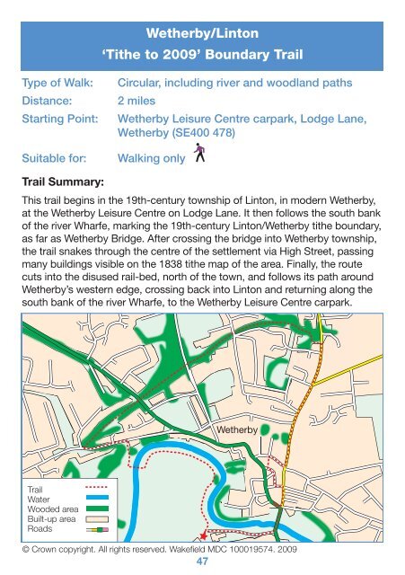
Wetherby/Linton - Tracks in Time, the Leeds Tithe Map Project
Wetherby/Linton - Tracks in Time, the Leeds Tithe Map Project
Wetherby/Linton - Tracks in Time, the Leeds Tithe Map Project

Create successful ePaper yourself
Turn your PDF publications into a flip-book with our unique Google optimized e-Paper software.
DirectionsBeg<strong>in</strong> at <strong>We<strong>the</strong>rby</strong> Leisure Centre carpark, situated on land appear<strong>in</strong>gon <strong>the</strong> 1838 <strong>We<strong>the</strong>rby</strong> ti<strong>the</strong> map as flood pla<strong>in</strong>s yield<strong>in</strong>g no ti<strong>the</strong>. Go acrossLodge Lane, and walk to your right. Follow <strong>the</strong> footpath as far as<strong>We<strong>the</strong>rby</strong> Bridge.In turn<strong>in</strong>g left onto<strong>We<strong>the</strong>rby</strong> Bridge, youcross <strong>in</strong>to <strong>the</strong> first mappedarea of <strong>the</strong> township’s19th-century ti<strong>the</strong> map. Gohalfway across <strong>the</strong> bridgeand pause at its centre,turn<strong>in</strong>g to look upstream,to your left. Ahead you willnote a modern weir, andto its left, a salmon leap.Above <strong>the</strong> fish ladder, on<strong>the</strong> left bank of <strong>the</strong> river, isa modern hous<strong>in</strong>g estate. View from <strong>We<strong>the</strong>rby</strong> BridgeThis development sprung up<strong>in</strong> 2003 around a listed 18th-century stable block locally rumoured to havebeen used by <strong>the</strong> Yorkshire Hussars as barracks and accommodation forAs you walk along Lodge Lane, notice <strong>the</strong> semi-natural woodland to your left,along <strong>the</strong> steeply slop<strong>in</strong>g bank down to <strong>the</strong> river Wharfe. Look out for <strong>the</strong> flowersof ‘lords and ladies’, sometimes called ‘Jack-<strong>in</strong>-<strong>the</strong>-pulpit’, which have a chocolatespike surrounded by a cream cloak <strong>in</strong> <strong>the</strong> spr<strong>in</strong>g. By July <strong>the</strong> flower has gone, to bereplaced by a cluster of bright red berries on a green stalk. The bank to your right iscovered <strong>in</strong> harebells <strong>in</strong> mid-summer and bright yellow common cat’s ear which looksa bit like dandelion.When cross<strong>in</strong>g <strong>the</strong> bridge over <strong>the</strong> river Wharfe, look out for goosanders, a type ofsaw-bill duck, on <strong>the</strong> water below. The female has a brown head and grey body,<strong>the</strong> male has a dark green head and black back with white on <strong>the</strong> w<strong>in</strong>gs and a paleunderside. Both have long, th<strong>in</strong>, red beaks with serrated edges for gripp<strong>in</strong>g fish; <strong>the</strong>irfavourite food. Notice also <strong>the</strong> fish pass on your left, which helps fish negotiate <strong>the</strong>big weir and migrate upstream to <strong>the</strong>ir spawn<strong>in</strong>g grounds.<strong>We<strong>the</strong>rby</strong> Bridge has existed s<strong>in</strong>ce at least 1233, when Archbishop of York, Walterde Grey, forgave <strong>the</strong> s<strong>in</strong>s of those who contributed to its construction. The orig<strong>in</strong>albridge was 3.5 metres wide and hump-backed, with four arches. It suffered frequentflood damage and was often repaired. The bridge was widened and raised <strong>in</strong> 1773follow<strong>in</strong>g a severe flood, and aga<strong>in</strong> <strong>in</strong> 1826. The present bridge is <strong>the</strong> result of <strong>the</strong>semodifications. A draft order for a county estreat of £10 to repair ‘holes and breaks<strong>in</strong> <strong>the</strong> pavement’ of <strong>We<strong>the</strong>rby</strong> Bridge (QS1/9/1/7/1), dated 1670, is held by WestYorkshire Archive Service.48
Go across <strong>the</strong> bridge and turn to your left, walk<strong>in</strong>g straight aheadto <strong>the</strong> pedestrian cross<strong>in</strong>g. Go over <strong>the</strong> road us<strong>in</strong>g <strong>the</strong> cross<strong>in</strong>gand walk to your right, pass<strong>in</strong>g shops and gardens on your left.Accord<strong>in</strong>g to <strong>the</strong> <strong>We<strong>the</strong>rby</strong> ti<strong>the</strong> map, <strong>in</strong> 1838, <strong>the</strong> gardens here were<strong>the</strong> site of a house and cottages, belong<strong>in</strong>g to George Francis Barlowand Robert Akers respectively. These properties were leased to familiesnamed Dixon, Hartley, Levann, Lawrence, Grieves, and Heckles.At <strong>the</strong> junction with High Street, turn left <strong>in</strong>to what has long beenreferred to as <strong>the</strong> Great North Road (High Street). Directly oppositeyou, on <strong>the</strong> o<strong>the</strong>r side of <strong>the</strong> road, is <strong>the</strong> fi rst of ten <strong>in</strong>ns l<strong>in</strong><strong>in</strong>g this majorroute north. The existence of so many pubs so close toge<strong>the</strong>r illustrates<strong>We<strong>the</strong>rby</strong>’s former status as an important stag<strong>in</strong>g post on <strong>the</strong> longjourney between London and Ed<strong>in</strong>burgh.Prior to <strong>the</strong> implementation of rail travel <strong>in</strong> Brita<strong>in</strong>, stage coacheswere <strong>the</strong> fastest way to travel <strong>the</strong> country. A journey from London toEd<strong>in</strong>burgh took around ten days at an average speed of ten miles perhour, and various stopp<strong>in</strong>g po<strong>in</strong>ts or stag<strong>in</strong>g posts were needed to resthorses and travellers along <strong>the</strong> way. On <strong>the</strong> London-Ed<strong>in</strong>burgh route,<strong>the</strong>se stag<strong>in</strong>g posts were approximately 14 miles apart. Settlementswhere <strong>the</strong> stage coach spent <strong>the</strong> night consequently heaved with <strong>in</strong>nsand hotels of various qualities, often with stabl<strong>in</strong>g facilities attached. Thefi rst public house <strong>in</strong> <strong>We<strong>the</strong>rby</strong>’s High Street, The George and Dragon,was one such refuge, and is listed <strong>in</strong> <strong>the</strong> 1838 ti<strong>the</strong> apportionmentas belong<strong>in</strong>g to Qu<strong>in</strong>t<strong>in</strong> Rhodes. The pub had its own malt kiln at thistime for brew<strong>in</strong>g beer, and a female <strong>in</strong>n keeper, Mary Burley, rented <strong>the</strong>property.Proceed ahead now, along High Street, pass<strong>in</strong>g <strong>the</strong> sites of a houseand shop belong<strong>in</strong>g to Robert Akers, and cottages belong<strong>in</strong>g to WilliamGreen, on your left-hand side. In 1838, Robert Akers resided <strong>in</strong> <strong>the</strong>house attached to his shop here, with William Green leas<strong>in</strong>g three of hiscottages to families by <strong>the</strong> names of Crosland, Thackray and Wigg<strong>in</strong>s,and liv<strong>in</strong>g <strong>in</strong> <strong>the</strong> fourth. On <strong>the</strong> opposite side of <strong>the</strong> road, to your right,was a house and associated build<strong>in</strong>gs belong<strong>in</strong>g to James Horner, whoresided <strong>the</strong>re.Cont<strong>in</strong>ue ahead, to <strong>the</strong> Red Lion on your left-hand side. This <strong>in</strong>n islisted <strong>in</strong> <strong>the</strong> <strong>We<strong>the</strong>rby</strong> ti<strong>the</strong> apportionment as belong<strong>in</strong>g to Samuel andThomas Jackson. The tenant publican, who lived <strong>in</strong> <strong>the</strong> house attachedto <strong>the</strong> <strong>in</strong>n, was a Joesph Sayer. The Red Lion stood next door to afur<strong>the</strong>r public house, listed <strong>in</strong> <strong>the</strong> apportionment as The Crown Inn andbelong<strong>in</strong>g to William Atk<strong>in</strong>son. Atk<strong>in</strong>son ran <strong>the</strong> pub himself, and <strong>the</strong>50
same build<strong>in</strong>g can be seen stand<strong>in</strong>g here today. Directly opposite <strong>the</strong>setwo public houses, across <strong>the</strong> road, is <strong>the</strong> entrance to Gas House Lane.This lane is so called ow<strong>in</strong>g to <strong>the</strong> Gas Works that opened here <strong>in</strong> 1845.The works had two gas holders and produced ‘town gas’, a gaseous fuelmanufactured from coal as a by-product of <strong>the</strong> cok<strong>in</strong>g process. The gaswas piped to its customers for light<strong>in</strong>g, cook<strong>in</strong>g, and heat<strong>in</strong>g. Town gaswas superseded by natural gas between 1966 and 1976. A blue plaque<strong>in</strong> Gas House Lane gives <strong>in</strong>formation about its history.Walk past <strong>the</strong> Crown Inn now and turn left <strong>in</strong>to Cross Street. Stophere for a moment and look diagonally across <strong>the</strong> junction to yourright. On this spot, <strong>in</strong> 1838, stood <strong>the</strong> Golden Lion Inn and associatedbuild<strong>in</strong>gs, owned by Dorothy Lawson. The <strong>in</strong>n was leased to ano<strong>the</strong>rfemale publican, Hannah Hall. All <strong>the</strong> build<strong>in</strong>gs associated with <strong>the</strong>Golden Lion still stand, <strong>in</strong>clud<strong>in</strong>g <strong>We<strong>the</strong>rby</strong>’s only rema<strong>in</strong><strong>in</strong>g stable yard,and <strong>the</strong> build<strong>in</strong>gs comprise <strong>the</strong> town’s oldest surviv<strong>in</strong>g pub complex.The Golden Lion, however, was not always known as such. It seems<strong>the</strong> <strong>in</strong>n was plagued by frequent name changes. In <strong>the</strong> 1838 ti<strong>the</strong>apportionment <strong>the</strong> <strong>in</strong>n is dist<strong>in</strong>ctly listed as ‘The Golden Lion’, but onlyfourteen years earlier, <strong>in</strong> <strong>the</strong> 1824 <strong>We<strong>the</strong>rby</strong> sale catalogue, <strong>the</strong> samepub is referred to as ‘The Devonshire Arms’. William Spencer Cavendish,<strong>the</strong> 6th Duke of Devonshire owned n<strong>in</strong>e-tenths of <strong>the</strong> manor andtownship of <strong>We<strong>the</strong>rby</strong> <strong>in</strong> 1824, ow<strong>in</strong>g to his family’s gradual <strong>in</strong>crease <strong>in</strong>land hold<strong>in</strong>gs <strong>the</strong>re s<strong>in</strong>ce <strong>the</strong> 17th century. There were consequently twopubs <strong>in</strong> <strong>the</strong> town named ‘The Devonshire Arms’. One of <strong>the</strong>se becameThe Golden Lion, <strong>the</strong> o<strong>the</strong>r, now demolished, stood on <strong>the</strong> site of <strong>the</strong>Conservative club build<strong>in</strong>g (Halifax Estate Agency) <strong>in</strong> Westgate.The 6th Duke of Devonshire rema<strong>in</strong>ed a bachelor all his life and spent agood deal of his time improv<strong>in</strong>g his vast estates and gardens, sometimesto <strong>the</strong> po<strong>in</strong>t of rebuild<strong>in</strong>g villages <strong>in</strong> order to improve his view! In 1824,<strong>the</strong> Duke sold <strong>the</strong> manor of <strong>We<strong>the</strong>rby</strong> to pay for such improvements toChatsworth House. This sale may have sparked <strong>the</strong> name change at <strong>the</strong>Golden Lion, which later became known as The Brunswick Hotel, andis currently, Harris’s Bar. The surviv<strong>in</strong>g stable block has been converted<strong>in</strong>to offi ces known as Brunswick Court. Two blue plaques attached to<strong>the</strong>se build<strong>in</strong>gs expla<strong>in</strong> <strong>the</strong>ir history for passers-by.The sale particulars of 1824 are held by West Yorkshire Archive Service as part of<strong>the</strong> <strong>We<strong>the</strong>rby</strong> Manorial Records 1608-1846 (WYL160/98)A poster advertis<strong>in</strong>g <strong>the</strong> sale of ‘The Devonshire Arms’ <strong>in</strong> 1873 is held by WestYorkshire Archive Service (WYL1487/224) and presumably references <strong>the</strong> publichouse <strong>in</strong> Westgate, which reta<strong>in</strong>ed <strong>the</strong> title after <strong>the</strong> Duke’s 1824 sale.51
Walk to your left along Cross Street, pass<strong>in</strong>g several propertiesappear<strong>in</strong>g on <strong>the</strong> 1838 <strong>We<strong>the</strong>rby</strong> ti<strong>the</strong> map. In 1838, <strong>the</strong> properties herewere, from left to right, The Old Star Inn and stables, belong<strong>in</strong>g to ElizabethWhitaker, and houses and shops owned by Thomas Whitehouse, WalterWigg<strong>in</strong>s, and Thomas Rob<strong>in</strong>son. Elizabeth Whitaker ran The Old Star Innherself, whereas Whitehouse, Wigg<strong>in</strong>s, and Rob<strong>in</strong>son leased <strong>the</strong>ir propertiesto men by <strong>the</strong> names of Barstow and Granger, Barnabas Dalby, and NathanLeak, respectively. Most of <strong>the</strong> build<strong>in</strong>gs mentioned here by <strong>the</strong> ti<strong>the</strong>apportionment, still stand. The Old Star is no longer an <strong>in</strong>n, but <strong>the</strong> o<strong>the</strong>rbuild<strong>in</strong>gs reta<strong>in</strong> <strong>the</strong>ir use as dwell<strong>in</strong>gs and shops.Halfway down CrossStreet, make a right turn,go<strong>in</strong>g across <strong>the</strong> roadand <strong>in</strong>to The Shambles.Built <strong>in</strong> 1811 by <strong>the</strong> Dukeof Devonshire, with <strong>the</strong> aidof <strong>the</strong> Atk<strong>in</strong>sons, architectsof York, <strong>the</strong>se permanent,covered stalls were erectedto accommodate <strong>the</strong> townsmany butcher’s trade stands.In 1888, The Shambleswas converted <strong>in</strong>to anopen market sell<strong>in</strong>g poultry The Shamblesand dairy produce, but <strong>the</strong>build<strong>in</strong>gs on your left have rema<strong>in</strong>ed largely unchanged s<strong>in</strong>ce <strong>the</strong> <strong>We<strong>the</strong>rby</strong>ti<strong>the</strong> map, suggest<strong>in</strong>g <strong>the</strong>y were not altered by <strong>the</strong> transition.In 1838, <strong>the</strong> shops on your left here were leased to Samuel Varley by <strong>the</strong>irowner, Richard Fountayne Wilson. On your right-hand side if you hadwalked through The Shambles that year, you would have passed a houseleased to William S<strong>in</strong>clair by James Barstow, followed by several cottagesand shops belong<strong>in</strong>g to Qu<strong>in</strong>t<strong>in</strong> Rhodes, and leased to families also namedBarstow, Grieves and Dawson. F<strong>in</strong>ally, The Crown Inn and build<strong>in</strong>gs,owned and presided over by its publican, William Atk<strong>in</strong>son, stood at <strong>the</strong>end of <strong>the</strong> street. This must have been a very busy thoroughfare <strong>in</strong> 1838,with <strong>the</strong> town’s <strong>in</strong>habitants need<strong>in</strong>g to buy fresh meat on a daily basis.No doubt <strong>the</strong>re was also a dist<strong>in</strong>ct, unpleasant smell here result<strong>in</strong>g fromwaste products expelled from <strong>the</strong> butchers’ shops. At <strong>the</strong> far end of TheShambles, on your left-hand side, is a blue plaque, summaris<strong>in</strong>g <strong>the</strong> narrowstreet’s history.52
Walk on ahead now,emerg<strong>in</strong>g from TheShambles <strong>in</strong>to ano<strong>the</strong>rarea of <strong>We<strong>the</strong>rby</strong> thathas changed very little<strong>in</strong> size and shape,s<strong>in</strong>ce its depiction on<strong>the</strong> 19th-century ti<strong>the</strong>map. The Market Placeappears on <strong>the</strong> mapmuch <strong>the</strong> same as it doestoday, and is listed <strong>in</strong> <strong>the</strong>ti<strong>the</strong> apportionment asbelong<strong>in</strong>g to <strong>the</strong> YorkshireWest Rid<strong>in</strong>g Magistrates,along with <strong>the</strong> Town Hall,which occupied a site <strong>in</strong><strong>the</strong> modern park<strong>in</strong>g area,slightly to <strong>the</strong> left of, andMarket Place and <strong>the</strong> Town Hallfur<strong>the</strong>r back, than <strong>the</strong>current build<strong>in</strong>g.The Town Hall was a much smaller structure <strong>in</strong> 1838, be<strong>in</strong>g approximatelya quarter <strong>the</strong> size of its later replacement and may have had a gaol <strong>in</strong> <strong>the</strong>basement. The current build<strong>in</strong>g was established <strong>in</strong> 1845 to serve <strong>We<strong>the</strong>rby</strong>’sgrow<strong>in</strong>g population, and accommodated a church school on <strong>the</strong> groundfloor until 1895. Upstairs, were <strong>the</strong> Magistrates’ Courts, which rema<strong>in</strong>ed <strong>in</strong><strong>the</strong> Town Hall until <strong>the</strong> 1960s, when <strong>the</strong>y moved <strong>in</strong>to larger accommodationon Boston Road, attached to <strong>the</strong> police station. The small arch between <strong>the</strong>ma<strong>in</strong> chimneys on <strong>the</strong> front of <strong>the</strong> Town Hall build<strong>in</strong>g orig<strong>in</strong>ally carried bellsthat were used to summon <strong>the</strong> local fire brigade.On <strong>the</strong> site of <strong>the</strong> Town Hall, <strong>in</strong> 1838, <strong>the</strong>re stood a chapel-of-ease,belong<strong>in</strong>g, accord<strong>in</strong>g to <strong>the</strong> ti<strong>the</strong> apportionment, to <strong>the</strong> <strong>in</strong>habitants of<strong>We<strong>the</strong>rby</strong>. At this po<strong>in</strong>t, until <strong>the</strong> build<strong>in</strong>g of St James’ church <strong>in</strong> 1842,<strong>We<strong>the</strong>rby</strong> was <strong>in</strong> <strong>the</strong> Parish of Spofforth and as such, had no church of itsown. Chapels-of-ease were provided to areas of parishes with significantpopulations that lay some distance from <strong>the</strong> mo<strong>the</strong>r church. The chapelbuild<strong>in</strong>g at <strong>We<strong>the</strong>rby</strong> was slightly bigger than <strong>the</strong> current Town Hall, mak<strong>in</strong>g<strong>We<strong>the</strong>rby</strong> Rural District Council yearbooks, Fireman’s record book and papers ofschools, medical officers, midwives etc., are held by West Yorkshire Archive Serviceas part of <strong>the</strong> <strong>We<strong>the</strong>rby</strong> Historical Society Collections (WYL1487).53
it quite large for a chapel-of-ease. Records of baptisms be<strong>in</strong>g performedat <strong>the</strong> chapel ra<strong>the</strong>r than <strong>the</strong> parish church, exist from 1783, however thisis not a reliable <strong>in</strong>dicator of when <strong>the</strong> chapel was built. Usually, chapelsof-easeprovided local accessto regular religious services,but marriages, baptisms andfunerals were performed at <strong>the</strong>mo<strong>the</strong>r church. Consequently,<strong>We<strong>the</strong>rby</strong>’s chapel may alreadyhave existed before <strong>the</strong> firstbaptisms were held <strong>the</strong>re <strong>in</strong>1783. Indeed, ‘A TopographicalDictionary of England’ (1848),edited by Samuel Lewis, refersto St James’ church at <strong>We<strong>the</strong>rby</strong>as hav<strong>in</strong>g replaced a ‘formersmall ancient edifice’.M<strong>in</strong>utes, faculties and specifi cations of worksamongst St James’ parish records. (RDP105)Keep<strong>in</strong>g <strong>the</strong> Town Hall on yourleft, walk around <strong>the</strong> edge of <strong>the</strong> Market Place and pass <strong>in</strong> front of <strong>the</strong>bank and <strong>the</strong> Black Bull public house on your right. If you had passedthis way <strong>in</strong> 1838, on <strong>the</strong> site of <strong>the</strong> current bank you would have found ahouse, shop and build<strong>in</strong>gs belong<strong>in</strong>g to William Hill, and leased, possiblyto a relative, John Hill. The Black Bull however, has changed little s<strong>in</strong>ce <strong>the</strong>ti<strong>the</strong> map was drawn. Accord<strong>in</strong>g to <strong>the</strong> ti<strong>the</strong> apportionment, this build<strong>in</strong>gwas an <strong>in</strong>n of <strong>the</strong> same name <strong>in</strong> 1838. The Black Bull belonged to Qu<strong>in</strong>t<strong>in</strong>Rhodes, and was let to a female publican, Ann Brown.As illustrated by <strong>the</strong> <strong>We<strong>the</strong>rby</strong> ti<strong>the</strong> map, after <strong>the</strong> Black Bull, you wouldhave passed a fur<strong>the</strong>r two properties on your right-hand side beforereach<strong>in</strong>g <strong>the</strong> modern junction of <strong>the</strong> Market Place with Church Street. Theseproperties were a house, out-build<strong>in</strong>gs and garden, and <strong>the</strong> Wheat SheafPublic House, belong<strong>in</strong>g to George Francis Barlow and Barnabas Brownrespectively.Just before <strong>the</strong> junction with <strong>the</strong> ma<strong>in</strong> road, Westgate, turn right <strong>in</strong>toChurch Street, and notice <strong>the</strong> blue plaque chart<strong>in</strong>g its history. As youRecords of <strong>the</strong> church school <strong>in</strong> <strong>We<strong>the</strong>rby</strong> Town Hall from 1675, and baptismregisters for <strong>the</strong> chapel-of-ease from 1783 are held by WYAS as part of <strong>the</strong> parishrecords of <strong>We<strong>the</strong>rby</strong>, St James (RDP105).A note signed ‘Wm Hill, butcher of <strong>We<strong>the</strong>rby</strong>’ (C176/25) concern<strong>in</strong>g <strong>the</strong> sale ofgoods is held by West Yorkshire Archive Service as part of <strong>the</strong> Hill family papers(C176).54
will see, this street leads to <strong>We<strong>the</strong>rby</strong>’s Victorian church of St James, builtto replace <strong>the</strong> town’s chapel-of-ease <strong>in</strong> 1842. As such, on <strong>the</strong> 1838 ti<strong>the</strong>map, <strong>the</strong> first section of Church Street is somewhat undeveloped andappears only as a passageway between build<strong>in</strong>gs. On your left-hand sidehere, accord<strong>in</strong>g to <strong>the</strong> ti<strong>the</strong> apportionment, <strong>the</strong>re stood a house and shopowned by William Willey. Fur<strong>the</strong>r along Church Street, still on your left, weretwo more houses with shops, both belong<strong>in</strong>g to George Francis Barlowand be<strong>in</strong>g let to William Bro<strong>the</strong>rton and Thomas Precious. It is likely thatthis street was fur<strong>the</strong>r developed when it became necessary to use it as<strong>the</strong> ma<strong>in</strong> route to <strong>the</strong> new church and school for <strong>the</strong> poor that was erectedbeside <strong>the</strong> place of worship. Church Street, none<strong>the</strong>less, has never beenwidened sufficiently for vehicular access and rema<strong>in</strong>s a pedestrian route tothis day.On reach<strong>in</strong>g <strong>the</strong> junction, pause and look to your left across BankStreet, labelled on <strong>the</strong> <strong>We<strong>the</strong>rby</strong> ti<strong>the</strong> map as ‘Back Lane’. Here youwill note <strong>the</strong> current Methodist Church, orig<strong>in</strong>ally built as a WesleyanChapel <strong>in</strong> 1829. This build<strong>in</strong>g was erected to replace a previous meet<strong>in</strong>ghouse <strong>in</strong> Fox Yard, adjacent to <strong>the</strong> chapel, on land purchased from MrJames Wigg<strong>in</strong>s for <strong>the</strong> sum of £760. This chapel build<strong>in</strong>g is entirelyunchanged from its appearance on <strong>the</strong> 1838 <strong>We<strong>the</strong>rby</strong> ti<strong>the</strong> map, when itis listed as belong<strong>in</strong>g to <strong>the</strong> Trustees of <strong>the</strong> Methodist Chapel.The term ‘Back Lane’, by which Bank Street was known <strong>in</strong> 1838, is a verycommon road name, and usually recalls an ancient access track runn<strong>in</strong>gacross <strong>the</strong> back of a series of small dwell<strong>in</strong>gs with long, narrow gardens.These dwell<strong>in</strong>gs were known as tofts and were often established <strong>in</strong> <strong>the</strong>medieval period to house rural peasant families who toiled <strong>in</strong> <strong>the</strong> open fieldsbelong<strong>in</strong>g to <strong>the</strong> local manor. These orig<strong>in</strong>al dwell<strong>in</strong>gs had been demolishedor replaced by <strong>the</strong> time <strong>the</strong> <strong>We<strong>the</strong>rby</strong> ti<strong>the</strong> map was drawn, but surviv<strong>in</strong>gnarrow land plots <strong>in</strong> 1838 are strong evidence for <strong>the</strong>ir prior existence. ‘BackLane’, now Bank Street, may consequently mark one of <strong>the</strong> earliest parts of<strong>We<strong>the</strong>rby</strong>.Despite his brewery be<strong>in</strong>g absent from <strong>the</strong> ti<strong>the</strong> map of 1838, <strong>in</strong> 1839, Qu<strong>in</strong>t<strong>in</strong>Rhodes, later <strong>the</strong> owner of <strong>We<strong>the</strong>rby</strong> Brewery, was able to offer a major contributionto <strong>the</strong> construction of St James’ church. Both Rhodes and Richard FountayneWilson, Lord of <strong>the</strong> Manor of Ingmanthorpe, donated equal sums of £300 to <strong>the</strong>build<strong>in</strong>g project. Rhodes also provided <strong>the</strong> newly built church with a peel of six bellsand an organ <strong>in</strong> 1845. The woodwork <strong>in</strong> St James’ church is by Robert Thompson ofKilburn, who marks his work with a carved mouse. If you have time, it is worth a visitto seek out <strong>the</strong>se church mice!The parish records of St James’ church 1675-2006 (RDP105) are held by WestYorkshire Archive Service.55
Cross Bank Street now, turn<strong>in</strong>g right to pass <strong>in</strong> front of what is nowa carpark and beer garden. Mov<strong>in</strong>g towards <strong>the</strong> junction with NorthStreet, if you had walked this way <strong>in</strong> 1838, you would have passed <strong>in</strong>front of several houses, cottages and shops. The first of <strong>the</strong>se houses, on<strong>the</strong> site of <strong>the</strong> current carpark and beer garden, was owned by GeorgeFrancis Barlow and let to John Heckles. Next was a series of five cottagesbelong<strong>in</strong>g to Thomas Wigg<strong>in</strong>s. These were rented by families with <strong>the</strong>names Whitfield, Dickens, Braithwaite and Shaw, and by a lone female,Jane Wh<strong>in</strong>cup. F<strong>in</strong>ally, at <strong>the</strong> end of this row, stood <strong>the</strong> dwell<strong>in</strong>g andbus<strong>in</strong>ess of Thomas Wigg<strong>in</strong>s himself, on a plot consist<strong>in</strong>g of a house,shop and outbuild<strong>in</strong>gs.Wigg<strong>in</strong>s’ plot was ra<strong>the</strong>r large, and <strong>the</strong> build<strong>in</strong>gs at <strong>the</strong> end of Bank Streetstretched much fur<strong>the</strong>r <strong>in</strong>to North Street than <strong>the</strong> current properties andfootpath do. This resulted <strong>in</strong> <strong>the</strong>m block<strong>in</strong>g almost half <strong>the</strong> width of <strong>the</strong>Great North Road (North Street) at this po<strong>in</strong>t, creat<strong>in</strong>g a famous bottleneck.The narrow<strong>in</strong>g of <strong>the</strong> Great North Road at <strong>We<strong>the</strong>rby</strong> was 198 milesequidistant from London and Ed<strong>in</strong>burgh and created a gap only 4 metreswide at its f<strong>in</strong>est po<strong>in</strong>t. The gap was notoriously difficult to negotiate, andit was not uncommon for <strong>the</strong> wheels of carriages travell<strong>in</strong>g <strong>in</strong> oppositedirections through <strong>the</strong> town, to become locked toge<strong>the</strong>r as <strong>the</strong>y passed.The road was f<strong>in</strong>ally widened <strong>in</strong> 1929 by demolish<strong>in</strong>g several propertiesthat were caus<strong>in</strong>g <strong>the</strong> problem, <strong>in</strong>clud<strong>in</strong>g <strong>the</strong> Bowl<strong>in</strong>g Green Hotel thatwas later built on Thomas Wigg<strong>in</strong>s’ plot. S<strong>in</strong>ce <strong>the</strong> demolition, <strong>the</strong> plot at<strong>the</strong> end of Bank Street has been planted as gardens. A current <strong>We<strong>the</strong>rby</strong>resident, aged 61, remembers his fa<strong>the</strong>r’s tales of <strong>the</strong> bottle-neck <strong>in</strong> NorthStreet. His fa<strong>the</strong>r was <strong>in</strong> <strong>the</strong> South Nott<strong>in</strong>ghamshire Hussars, a territorialartillery regiment, and often recounted <strong>the</strong> challenge of negotiat<strong>in</strong>g a fieldgun and limber through <strong>the</strong> narrow gap!At <strong>the</strong> junction of Bank Street with North Street, look diagonallyacross North Street to your right. Here, at <strong>the</strong> corner of Horse Fair,which suggests <strong>the</strong> street’s former use as a place for <strong>the</strong> buy<strong>in</strong>g andsell<strong>in</strong>g of horses, The Angel Inn still stands, unchanged s<strong>in</strong>ce its depictionon <strong>the</strong> <strong>We<strong>the</strong>rby</strong> ti<strong>the</strong> map. In <strong>the</strong> 1838 ti<strong>the</strong> apportionment, The Angel islisted as an <strong>in</strong>n of <strong>the</strong> same name, belong<strong>in</strong>g to Edw<strong>in</strong> Greenwood, andleased to John Clemishaw. Fur<strong>the</strong>r down Horse Fair, beh<strong>in</strong>d this publichouse, <strong>the</strong>re also stood a cattle market and several houses and shops, on<strong>the</strong> current site of Marks and Spencer. These dwell<strong>in</strong>gs and bus<strong>in</strong>essesbelonged to William Hill and William Willey, who resided <strong>the</strong>re, and toGeorge Francis Barlow, who leased a house and build<strong>in</strong>gs <strong>in</strong> Horsefair toWilliam Naylor.56
Turn left <strong>in</strong>to North Street, and walk past <strong>the</strong> garden of rest, laid over<strong>the</strong> site of <strong>the</strong> build<strong>in</strong>gs demolished to widen <strong>the</strong> Great North Roadbottle-neck. Note <strong>the</strong> trophies displayed here, celebrat<strong>in</strong>g <strong>the</strong> success of<strong>the</strong> people of <strong>We<strong>the</strong>rby</strong> <strong>in</strong> National Floral Competitions. Accord<strong>in</strong>g to <strong>the</strong>1838 ti<strong>the</strong> map, part of this garden also occupies plot numbers 281 and283, listed as a row of four cottages belong<strong>in</strong>g to John Clemishaw and TheBlacksmiths Arms public house, belong<strong>in</strong>g to Qu<strong>in</strong>t<strong>in</strong> Rhodes. The cottageshere were leased to families by <strong>the</strong> names of Harrison, Lawrence, Grangerand Fawcett. The Blacksmiths Arms was run by publican, James Mason.The atmosphere of this now peaceful area has changed a great deal s<strong>in</strong>ce1838, when it was surely a bustl<strong>in</strong>g po<strong>in</strong>t of domestic and social life. Today<strong>the</strong> space is used <strong>in</strong> a ra<strong>the</strong>r more tranquil social capacity than might havebeen found <strong>in</strong> <strong>the</strong> Blacksmiths Arms, provid<strong>in</strong>g seat<strong>in</strong>g for residents andvisitors of <strong>We<strong>the</strong>rby</strong> alike to stop, chat and enjoy <strong>the</strong> floral displays.At <strong>the</strong> far end of <strong>the</strong> garden of rest, among <strong>the</strong> flower beds, is a structureknown as <strong>the</strong> Huguenot Arch. It bears a blue plaque describ<strong>in</strong>g its orig<strong>in</strong>al siteover a passageway between two houses at West End (or what is now knownas Westgate, near <strong>the</strong> library). Local legend has it that <strong>the</strong>se houses were builtby <strong>the</strong> descendants of Huguenot refugees from France. French Huguenotsor Calv<strong>in</strong>ists were members of <strong>the</strong> Protestant Reformed Church of France,which grew rapidly after <strong>the</strong> Reformation reached <strong>the</strong> country <strong>in</strong> <strong>the</strong> early16th century. The ensu<strong>in</strong>g French Wars of Religion and Protestant massacresthat took place later that century, drove many Huguenots from predom<strong>in</strong>antlyCatholic France, to more tolerant, Protestant countries, like England. AHuguenot or Calv<strong>in</strong>ist chapel has existed <strong>in</strong> <strong>We<strong>the</strong>rby</strong>, at <strong>the</strong> end of VictoriaStreet, s<strong>in</strong>ce 1815, and suggests <strong>the</strong>re must have been a significant FrenchProtestant community to warrant it. The stone set <strong>in</strong> <strong>the</strong> Huguenot arch has aFrench <strong>in</strong>scription and was laid on 19th January 1827. The <strong>in</strong>scription reads:‘ “Love your neighbour as yourself,” said <strong>the</strong> Evangelist’, but <strong>the</strong> significanceof <strong>the</strong> date is unknown. It has been surmised it may have l<strong>in</strong>ks to <strong>the</strong> Calv<strong>in</strong>istchapel, or mark <strong>the</strong> date of construction of <strong>the</strong> houses at West End.Cont<strong>in</strong>ue north past <strong>the</strong> bank on your left, occupy<strong>in</strong>g <strong>the</strong> former site ofcottages and a house owned by George Francis Barlow and let to JohnP. Hesselton and George Turner respectively. Pass <strong>the</strong> Swan and Talboton your right-hand side, display<strong>in</strong>g a fur<strong>the</strong>r blue plaque. The Swan andTalbot was first licensed <strong>in</strong> 1627, and was listed <strong>in</strong> <strong>the</strong> 1824 sale cataloguefor <strong>the</strong> town as hav<strong>in</strong>g ample stabl<strong>in</strong>g, a soldiers’ room (or dormitory forsleep<strong>in</strong>g a battalion) and a malt kiln with which to brew <strong>in</strong>dependently. Thecarriers of post (Royal Mail) departed from <strong>the</strong> now demolished stableshere, to <strong>Leeds</strong>.57
In 1838 however, <strong>the</strong> Swan andTalbot was listed <strong>in</strong> <strong>the</strong> <strong>We<strong>the</strong>rby</strong>ti<strong>the</strong> apportionment as simply,The Swan Inn. It had build<strong>in</strong>gsand a garden, belonged to Qu<strong>in</strong>t<strong>in</strong>Rhodes, and was let to WilliamTreffit. It seems <strong>the</strong> ‘Talbot’ partof <strong>the</strong> <strong>in</strong>n’s name must longhave existed, but may havebeen dropped for a short while,perhaps <strong>in</strong> petulance due to itsassociation with <strong>the</strong> Cavendishfamily, after <strong>the</strong> town’s sale by <strong>the</strong>6th Duke of Devonshire. ‘Talbot’refers to Elizabeth Talbot, or BessThe Swan and Talbotof Hardwick, <strong>the</strong> Countess ofShrewbury from 1527 to 1608. Thechildren of Elizabeth’s second marriage to Sir William Cavendish <strong>in</strong> 1547,are <strong>the</strong> ancestors of <strong>the</strong> Dukes of Devonshire whose family name rema<strong>in</strong>s‘Cavendish’ to this day. The form and shapes of <strong>the</strong> build<strong>in</strong>gs at <strong>the</strong> Swanand Talbot have changed somewhat s<strong>in</strong>ce <strong>the</strong>ir depiction on <strong>the</strong> <strong>We<strong>the</strong>rby</strong>ti<strong>the</strong> map of 1838. However, <strong>the</strong> pub’s current frontage appears 19thcentury,suggest<strong>in</strong>g some of its Victorian fabric rema<strong>in</strong>s.A few yards fur<strong>the</strong>r along North Street on your left, is <strong>the</strong> Manor House.This build<strong>in</strong>g complex also appears on <strong>the</strong> <strong>We<strong>the</strong>rby</strong> ti<strong>the</strong> map, hav<strong>in</strong>gchanged very little <strong>in</strong> structural form s<strong>in</strong>ce 1838. Accord<strong>in</strong>g to <strong>the</strong> ti<strong>the</strong>apportionment, <strong>the</strong> manor house at this time was owned by George FrancisBarlow, and leased to John Johnson. Until <strong>the</strong> township of <strong>We<strong>the</strong>rby</strong> wassold, <strong>in</strong> 1824, by <strong>the</strong> 6th Duke of Devonshire, <strong>the</strong> gardens of <strong>We<strong>the</strong>rby</strong>Manor were also <strong>the</strong> site of <strong>the</strong> court leet. Court leets, or manorial courts,were established <strong>in</strong> <strong>the</strong> medieval period and had responsibility for settl<strong>in</strong>gcrim<strong>in</strong>al and moral justice matters with<strong>in</strong> <strong>the</strong> bounds of <strong>the</strong> manor.The Cavendish family were Lords of <strong>the</strong> Manor of <strong>We<strong>the</strong>rby</strong>, and as suchpresided over trials by jury and <strong>the</strong> issue of punishment <strong>in</strong> <strong>the</strong> manor from1602 to 1824. As well as settl<strong>in</strong>g local affairs, <strong>the</strong> manor court at <strong>We<strong>the</strong>rby</strong>also had responsibility for appo<strong>in</strong>t<strong>in</strong>g constables to keep social order,market <strong>in</strong>spectors to regulate trade, ‘bellmen’ or town criers to dissem<strong>in</strong>atenews, and p<strong>in</strong>ders, to impound stray animals.A Court Leet Presentment for <strong>We<strong>the</strong>rby</strong> Court Leet, dated 1826, (WYL1283) is heldby West Yorkshire Archive Service.58
Cont<strong>in</strong>ue along NorthStreet now, pass<strong>in</strong>gmodern hous<strong>in</strong>g and light<strong>in</strong>dustrial build<strong>in</strong>gs on bothsides of <strong>the</strong> road. Cross StJames’ Street. Accord<strong>in</strong>g to<strong>the</strong> <strong>We<strong>the</strong>rby</strong> ti<strong>the</strong> map, <strong>in</strong>1838 <strong>the</strong>re were no build<strong>in</strong>gsat this po<strong>in</strong>t on ei<strong>the</strong>r sideof North Street. To <strong>the</strong> leftwere gardens belong<strong>in</strong>g toEdw<strong>in</strong> Greenwood and <strong>the</strong>same George Francis Barlowwho owned <strong>We<strong>the</strong>rby</strong> ManorHouse. These were leasedby Barlow and Greenwoodto James Coates and JohnClemishaw respectively. North StreetTo <strong>the</strong> right was a largepiece of land associated with a row of cottages, owned by George FrancisBarlow, which stood a short distance away on <strong>the</strong> footpr<strong>in</strong>t of modernhouses (Farrier’s Court) opposite <strong>the</strong> entrance to Barleyfields Lane and <strong>the</strong>Total fill<strong>in</strong>g station. These dwell<strong>in</strong>gs were leased to Mary Fletcher, BryanWood, William Leake, John March, George Allen and Ann Thackray. To <strong>the</strong>left, flank<strong>in</strong>g <strong>the</strong> junction with Barleyfields Lane, stood a fur<strong>the</strong>r house andgarden, let by Edw<strong>in</strong> Greenwood to George Turner and several propertiesbelong<strong>in</strong>g to Qu<strong>in</strong>t<strong>in</strong> Rhodes, all ofwhich are now demolished. Thesewere houses with gardens, leasedto Hannah Breasley and JamesHall, along with a malt kiln used byQu<strong>in</strong>t<strong>in</strong> Rhodes himself. Opposite<strong>the</strong> house rented by James Hall,<strong>the</strong> Royal Oak Inn still stands on<strong>the</strong> right-hand side of North Street.The Royal Oak is listed <strong>in</strong> <strong>the</strong>19th-century ti<strong>the</strong> apportionmentas a public house of <strong>the</strong> samename belong<strong>in</strong>g to John Green andrented by a publican, John Craven.The Royal Oak59
Walk fur<strong>the</strong>r along North Street now, to <strong>the</strong> entrance to York Place.York Place is built on <strong>the</strong> site of a 19th-century open field belong<strong>in</strong>g toQu<strong>in</strong>t<strong>in</strong> Rhodes and be<strong>in</strong>g used as pasture. On <strong>the</strong> right-hand side of <strong>the</strong>road, opposite this junction, <strong>the</strong>re were several cottages <strong>in</strong> 1838, numberedplots 2 to 6 on <strong>the</strong> ti<strong>the</strong> map. These have all now been replaced by modernbuild<strong>in</strong>gs but were, at <strong>the</strong> time, owned by Edw<strong>in</strong> Greenwood and JohnGreen, who let <strong>the</strong>m to William Green, Charles Newsome, Thomas Garnettand John Esselton. John Green himself lived <strong>in</strong> <strong>the</strong> house at <strong>the</strong> end of <strong>the</strong>row.Cont<strong>in</strong>u<strong>in</strong>g up North Street, with York Road and an Esso fill<strong>in</strong>g stationon your right-hand side, you will come to <strong>the</strong> Masonic Hall on your left.The gates of <strong>the</strong> hall have <strong>the</strong> words Lascelles Calcaria and an <strong>in</strong>scriptiondescrib<strong>in</strong>g <strong>the</strong> lay<strong>in</strong>g of a foundation stone by Viscount Lascelles <strong>in</strong> 1927.Stop here for a moment and look back towards <strong>the</strong> fill<strong>in</strong>g station.Accord<strong>in</strong>g to <strong>the</strong> 1838 ti<strong>the</strong> apportionment, this Esso garage is built on<strong>the</strong> site of a plot of land known as The Croft. This belonged to Edw<strong>in</strong>Greenwood and was rented to William Powell for grass, but its namesuggests <strong>the</strong>re may once have been a dwell<strong>in</strong>g <strong>the</strong>re, as <strong>the</strong> term ‘croft’traditionally refers to a small farm or hold<strong>in</strong>g.Turn<strong>in</strong>g back to <strong>the</strong> Masonic Hall, go past <strong>the</strong> build<strong>in</strong>g, turn left, andclimb up to <strong>the</strong> level of <strong>the</strong> disused railway, part of <strong>the</strong> Church Fenton-Harrogate l<strong>in</strong>e, which opened <strong>in</strong> 1847/8. Plans for this railway at <strong>We<strong>the</strong>rby</strong>were at some stage <strong>in</strong> history, drawn onto <strong>the</strong> township’s ti<strong>the</strong> map <strong>in</strong>pencil. In 1838, a ti<strong>the</strong> plot here, known as Quarry Close, was used forgrass and let to Hannah Hall by Richard Fountayne Wilson. This plot waslater dissected by <strong>the</strong> <strong>Leeds</strong>-<strong>We<strong>the</strong>rby</strong> railway l<strong>in</strong>e <strong>in</strong> 1876. The <strong>Leeds</strong>-<strong>We<strong>the</strong>rby</strong> railway took some time to plan. It was orig<strong>in</strong>ally proposed by <strong>the</strong><strong>Leeds</strong>-York Railway Company <strong>in</strong> 1846, but a bill allow<strong>in</strong>g its constructionwas not passed by <strong>the</strong> Select Committee of <strong>the</strong> House of Commons until1866. The l<strong>in</strong>e f<strong>in</strong>ally began to be built by North Eastern Railways <strong>in</strong> 1871,and ran from Cross Gates (<strong>Leeds</strong>) to <strong>the</strong> exist<strong>in</strong>g Harrogate-Church Fentonl<strong>in</strong>e at this po<strong>in</strong>t. The 1847 station for <strong>the</strong> Harrogate-Church Fenton l<strong>in</strong>ewas <strong>in</strong> York Road. The pencil l<strong>in</strong>es drawn onto <strong>the</strong> <strong>We<strong>the</strong>rby</strong> ti<strong>the</strong> mapare labelled periodically with <strong>the</strong> letters ‘N.E.R’, but <strong>the</strong>se may have beenadded dur<strong>in</strong>g <strong>the</strong> 19th century, or <strong>in</strong> 1902, when <strong>the</strong> N.E.R added a fur<strong>the</strong>rbranch l<strong>in</strong>e, allow<strong>in</strong>g tra<strong>in</strong>s to run from Harrogate to <strong>the</strong> west, via <strong>Leeds</strong>. Anew station about a mile from where you are stand<strong>in</strong>g, serv<strong>in</strong>g passengersto Harrogate, <strong>Leeds</strong> and <strong>We<strong>the</strong>rby</strong>, opened <strong>in</strong> 1902 when York Road Stationclosed to passengers. The <strong>Leeds</strong>-<strong>We<strong>the</strong>rby</strong> railway l<strong>in</strong>e closed under <strong>the</strong>1964 Re-Shap<strong>in</strong>g of British Railways, better known as <strong>the</strong> ‘Beech<strong>in</strong>g Axe’.The disused track bed is now known locally as <strong>the</strong> Harland Way and is part60
of <strong>the</strong> SustransNational CycleNetwork, Route66.Walk straightahead follow<strong>in</strong>g<strong>the</strong> disusedtrack over landdeclared by <strong>the</strong>1832 <strong>We<strong>the</strong>rby</strong>ti<strong>the</strong> map to bea ‘LimestoneQuarry’. At ajunction of <strong>the</strong>tracks, take <strong>the</strong>left fork andcut across land Disused railwayrecorded <strong>in</strong> <strong>the</strong>ti<strong>the</strong> apportionment as Barley Field belong<strong>in</strong>g to Qu<strong>in</strong>t<strong>in</strong> Rhodes and usedfor arable and grass.Follow<strong>in</strong>g <strong>the</strong> track ahead, pass over Barleyfields Road. This roadappears on <strong>the</strong> <strong>We<strong>the</strong>rby</strong> ti<strong>the</strong> map as a wide access track to one of <strong>the</strong>four, orig<strong>in</strong>ally open fields, that fed <strong>the</strong> residents of <strong>We<strong>the</strong>rby</strong> <strong>in</strong> medievaltimes, prior to land enclosure. These fields were known to local people asBarley Field, Hall Field, West Field and Heuthwaite. Medieval peasants,perhaps liv<strong>in</strong>g <strong>in</strong> <strong>the</strong> tofts on Bank Street or ‘Back Lane’, would have farmeddesignated strips of <strong>the</strong>se fields on behalf of <strong>the</strong> manorial lord. In payment,<strong>the</strong> peasant families would have taken a portion of <strong>the</strong> produce <strong>the</strong>y helpedto cultivate. Barleyfields Road reta<strong>in</strong>s <strong>the</strong> name of <strong>the</strong> open field to which itled.West Yorkshire Archive Service holds a letter by Edw<strong>in</strong> Greenwood concern<strong>in</strong>g <strong>the</strong>disputed valuation of land to be sold for <strong>the</strong> 1846 proposal for <strong>the</strong> <strong>Leeds</strong>-<strong>We<strong>the</strong>rby</strong>l<strong>in</strong>e (11D74/3/73/182).The woodland along <strong>the</strong> track that you are walk<strong>in</strong>g on has largely developeds<strong>in</strong>ce <strong>the</strong> railway closed. It is young woodland, but it already provides a richhabitat for small song birds like <strong>the</strong> long-tailed tit, blackbird and chaff<strong>in</strong>ch. Somewoodland plants like dog’s mercury and enchanter’s nightshade are already gett<strong>in</strong>gestablished. As you walk, <strong>the</strong> railway track enters a series of steep-sided cutt<strong>in</strong>gswhere layer after layer of Magnesian Limestone has been exposed for <strong>the</strong> first time<strong>in</strong> 260 million years. The surface is now covered <strong>in</strong> a lattice of tree roots, climbersand Hart’s tongue fern.61
Walk straight aheadnow a little fur<strong>the</strong>ralong <strong>the</strong> disused railtrack, cross<strong>in</strong>g a fur<strong>the</strong>rti<strong>the</strong> plot, belong<strong>in</strong>g toRandall Gossip, whichwas part of Barley Field<strong>in</strong> 1838. Pause after astone bridge carriesQuarry Hill Lane over<strong>the</strong> track above you. Alittle way ahead <strong>the</strong> railbed of <strong>the</strong> Harrogate-Church Fenton l<strong>in</strong>e canbe seen, com<strong>in</strong>g <strong>in</strong> fromThe stone railway bridgeyour right. This railwayl<strong>in</strong>e already existed <strong>in</strong> 1876 when <strong>the</strong> <strong>Leeds</strong>-<strong>We<strong>the</strong>rby</strong> l<strong>in</strong>e, along which youare walk<strong>in</strong>g, was opened. The Harrogate-Church Fenton l<strong>in</strong>e was built <strong>in</strong>1848 by George Hudson, and <strong>the</strong> York and North Midland railway company.Pencil l<strong>in</strong>es depict<strong>in</strong>g this track have also been drawn onto <strong>the</strong> <strong>We<strong>the</strong>rby</strong>ti<strong>the</strong> map. The Harrogate-Church Fenton l<strong>in</strong>e operated for 116 years, and ithas <strong>the</strong> dubious honour of be<strong>in</strong>g <strong>the</strong> very first branch railway to close under<strong>the</strong> 1964 Beech<strong>in</strong>g Axe. The spot where <strong>the</strong> Harrogate-Church Fenton and<strong>Leeds</strong>-<strong>We<strong>the</strong>rby</strong> l<strong>in</strong>es met is labelled on <strong>the</strong> <strong>We<strong>the</strong>rby</strong> ti<strong>the</strong> map as be<strong>in</strong>g,<strong>in</strong> 1838, a large Limestone Quarry. The scar left by 19th-century methodsof m<strong>in</strong><strong>in</strong>g limestone by blast<strong>in</strong>g with dynamite can still be seen straddl<strong>in</strong>g<strong>the</strong> ‘V’ marked by <strong>the</strong> railway cutt<strong>in</strong>gs. To your right, beside <strong>the</strong> quarry,was Rock Cottage, a house and garden owned by Richard Richardson andleased to David Pick. It is likely that Pick was <strong>the</strong> foreman or manager of <strong>the</strong>quarry, which warranted his liv<strong>in</strong>g so close.Walk ahead now, cross<strong>in</strong>g a ti<strong>the</strong>plot labelled Quarry Hill on <strong>the</strong> 1838map, and also belong<strong>in</strong>g to RichardRichardson. Pass under a steel bridgecarry<strong>in</strong>g <strong>the</strong> road to Spofforth andHarrogate. This road appears on <strong>the</strong><strong>We<strong>the</strong>rby</strong> ti<strong>the</strong> map and is labelled ‘<strong>the</strong>Knarborough and <strong>We<strong>the</strong>rby</strong> Road’.The area just beyond <strong>the</strong> road bridgehere is <strong>the</strong> site of <strong>We<strong>the</strong>rby</strong>’s secondrailway station, built <strong>in</strong> 1902. TheThe steel road bridge62
station consisted of stone build<strong>in</strong>gs concentrated on one platform and aniron footbridge overhead. The front of <strong>the</strong> build<strong>in</strong>g was sheltered to allowpassengers to board stage coaches without exposure to <strong>the</strong> elements.The station was closed <strong>in</strong> 1964. A third station at <strong>We<strong>the</strong>rby</strong> Race Course,to which ‘Race Specials’ were run on race days, had already closed <strong>in</strong>1959. The build<strong>in</strong>gs here were f<strong>in</strong>ally demolished <strong>in</strong> <strong>the</strong> early 1970s and <strong>the</strong>station’s footpr<strong>in</strong>t is now a carpark used by walkers, cyclists and users of<strong>the</strong> sports fields west of <strong>the</strong> river Wharfe.In 1838 however, <strong>the</strong>re were no build<strong>in</strong>gs on <strong>the</strong> plot later occupied by<strong>We<strong>the</strong>rby</strong> Station. This spot simply marked <strong>the</strong> <strong>We<strong>the</strong>rby</strong> ti<strong>the</strong> boundarywith <strong>L<strong>in</strong>ton</strong> Liberty. A liberty was one or a group of manors, <strong>in</strong> which <strong>the</strong>rule of <strong>the</strong> manorial lord(s) was considered historically dom<strong>in</strong>ant over <strong>the</strong>power of <strong>the</strong> church. This meant, s<strong>in</strong>ce <strong>the</strong>ir medieval orig<strong>in</strong>s, ‘liberties’ hadnever paid ti<strong>the</strong>s to <strong>the</strong> church. Consequently, <strong>the</strong>y were excused mapp<strong>in</strong>gunder <strong>the</strong> 1836 Ti<strong>the</strong> Commutation Act that resulted <strong>in</strong> <strong>the</strong> creation of19th-century ti<strong>the</strong> maps. As such, <strong>the</strong> area of <strong>L<strong>in</strong>ton</strong> that borders <strong>We<strong>the</strong>rby</strong>township appears as a blank space on <strong>the</strong> <strong>L<strong>in</strong>ton</strong> ti<strong>the</strong> map.Walk straight ahead,through 19th-century<strong>L<strong>in</strong>ton</strong> Liberty, andexit <strong>the</strong> carpark on<strong>the</strong> station footpr<strong>in</strong>tvia an open<strong>in</strong>g to yourleft. Emerg<strong>in</strong>g <strong>in</strong>to<strong>L<strong>in</strong>ton</strong> Road, crossover and turn left alongit, until you reach aset of steps on yourright. Pause here fora moment. Accord<strong>in</strong>gto <strong>the</strong> <strong>We<strong>the</strong>rby</strong> ti<strong>the</strong>Site of <strong>We<strong>the</strong>rby</strong> Railway Stationmap, at <strong>the</strong> top of <strong>the</strong>sesteps, on <strong>the</strong>ir far side,stood a small garden and a t<strong>in</strong>y build<strong>in</strong>g, belong<strong>in</strong>g to Richard FountayneWilson, who leased <strong>the</strong> plot to William Webster. In 1838, <strong>L<strong>in</strong>ton</strong> Road wasknown as Sickl<strong>in</strong>ghall Road, be<strong>in</strong>g <strong>the</strong> ma<strong>in</strong> route out of <strong>We<strong>the</strong>rby</strong> towardsSickl<strong>in</strong>ghall. The road was owned and ma<strong>in</strong>ta<strong>in</strong>ed by <strong>the</strong> Yorkshire WestRid<strong>in</strong>g magistrates. A branch of <strong>L<strong>in</strong>ton</strong> Road is shown on <strong>the</strong> <strong>We<strong>the</strong>rby</strong>ti<strong>the</strong> map, turn<strong>in</strong>g down <strong>the</strong> slope to your right, along <strong>the</strong> same l<strong>in</strong>e as <strong>the</strong>modern steps.63
<strong>We<strong>the</strong>rby</strong> Union WorkhouseRegister of Deaths at <strong>We<strong>the</strong>rby</strong> UnionWorkhouse, from 1864. (WYL1756/1)Before leav<strong>in</strong>g <strong>L<strong>in</strong>ton</strong> Road, turnand look towards <strong>We<strong>the</strong>rby</strong> towncentre. On your left, a little way down<strong>L<strong>in</strong>ton</strong> Road, is <strong>the</strong> site of <strong>We<strong>the</strong>rby</strong>Union Workhouse. This workhousewas built <strong>in</strong> 1863 to replace a previousone <strong>in</strong> North Street, and consequentlydoes not appear on <strong>the</strong> 1838<strong>We<strong>the</strong>rby</strong> ti<strong>the</strong> map. The build<strong>in</strong>g herewas <strong>in</strong> operation as a workhouse until1948, when, with <strong>the</strong> establishmentof <strong>the</strong> NHS, it became Wharfe GrangeHospital, specialis<strong>in</strong>g <strong>in</strong> mental health.The hospital closed <strong>in</strong> 1993, andwas converted <strong>in</strong>to flats with modernhouses be<strong>in</strong>g built <strong>in</strong> <strong>the</strong> grounds.In <strong>the</strong> 1838 apportionment however,<strong>We<strong>the</strong>rby</strong>’s previous workhouse is notlisted as be<strong>in</strong>g <strong>in</strong> North Street. Ra<strong>the</strong>r,it is placed at <strong>the</strong> river end of CaxtonStreet (<strong>the</strong>n Quarry Hill), and was <strong>the</strong>nrun by Thomas Clark, who leased <strong>the</strong>facility from Richard Richardson.,To your right-hand side, oppositewhere <strong>the</strong> 1863 workhouse stood,is a wooded area, known locally asCrossley Park Wood. In 1838, thisarea was an orchard leased to WilliamWebster by Richard Fountayne Wilson.It is now ma<strong>in</strong>ta<strong>in</strong>ed by <strong>the</strong> WoodlandTrust.Extract from Register of Births, <strong>We<strong>the</strong>rby</strong>Union Workhouse (WYL1756/2)The records of <strong>We<strong>the</strong>rby</strong> Union Workhouse Infirmary and later, Wharfe GrangeHospital, from c.1864 (WYL1756), are held by West Yorkshire Archive Service.You may wish to walk along <strong>L<strong>in</strong>ton</strong> Road to look at <strong>the</strong> workhouse build<strong>in</strong>g. It iswell worth <strong>the</strong> small detour, but be sure to return to <strong>the</strong> top of <strong>the</strong> steps beforecont<strong>in</strong>u<strong>in</strong>g <strong>the</strong> trail.64
Descend <strong>the</strong> steps now,follow<strong>in</strong>g <strong>the</strong> sameroute as <strong>We<strong>the</strong>rby</strong>’s19th-century residents,down <strong>the</strong> steep slopeof Scaur Bank. At <strong>the</strong>bottom of <strong>the</strong> hill, walkstraight ahead, ignor<strong>in</strong>ga turn-off to <strong>the</strong> right,and <strong>the</strong>n turn sharplyleft across a modernfootbridge over <strong>the</strong>river Wharfe. In cross<strong>in</strong>g<strong>the</strong> river, you pass backfrom <strong>L<strong>in</strong>ton</strong> Liberty,<strong>in</strong>to <strong>the</strong> 19th-centurytownship of <strong>We<strong>the</strong>rby</strong> Scaur Bankand onto <strong>the</strong> unmappedand untithable flood pla<strong>in</strong>s of <strong>We<strong>the</strong>rby</strong> Ings.After cross<strong>in</strong>g <strong>the</strong> footbridge, turn left and follow <strong>the</strong> path along <strong>the</strong>river bank. <strong>We<strong>the</strong>rby</strong> Ings rema<strong>in</strong>s a flood pla<strong>in</strong> and is currently laid out assports fields. As you walk, look across <strong>the</strong> river to <strong>the</strong> opposite bank.There are good views to <strong>the</strong> rear of <strong>the</strong> properties fac<strong>in</strong>g onto Westgateand Scott Lane. If you had passed this way <strong>in</strong> 1838, you would first havenoted build<strong>in</strong>gs after <strong>the</strong> modern block of flats recently built on <strong>the</strong> site of<strong>the</strong> old boat<strong>in</strong>g station. The first of <strong>the</strong>se properties were three cottagesand gardens, let to James Dawson, James Kirk and Thomas Uttley, by <strong>the</strong>Rev. James Geldart. Follow<strong>in</strong>g <strong>the</strong>se were several fur<strong>the</strong>r cottages, groupedtoge<strong>the</strong>r, and a row of small gardens. Beh<strong>in</strong>d <strong>the</strong>m stood <strong>the</strong> workhousementioned at <strong>the</strong> end of Caxton Street <strong>in</strong> <strong>the</strong> <strong>We<strong>the</strong>rby</strong> ti<strong>the</strong> apportionment.These cottages and gardens were owned by George Francis Barlow andThomas Wheelhouse, who let <strong>the</strong>m to tenants named Hesselton, Simpson,Brogden, Wharton, Dalby and Lister. A school house, and Georgian BathHouse that still stands today, completed <strong>the</strong> strip of properties on <strong>the</strong> riverbank. These were owned by John Clayton and leased to John Hesslop andJohn Thompson respectively.As you cross <strong>the</strong> bridge, take a close look at <strong>the</strong> tree tops. The common alder lovesto grow next to water and has little cone-like fruit and chocolate-brown catk<strong>in</strong>s. Asyou look up and down <strong>the</strong> river, you might be lucky enough to catch sight of an otter,but most will have to be content with not<strong>in</strong>g <strong>the</strong> aerobatics of <strong>the</strong> house mart<strong>in</strong>s andswallows that skim <strong>the</strong> water.65
From <strong>the</strong> 17th century,bath houses <strong>in</strong> Yorkshire,Derbyshire and Durhamwere relatively common. The<strong>We<strong>the</strong>rby</strong> bath house wasused for cold water <strong>the</strong>rapy,which <strong>in</strong>volved several dips<strong>in</strong> <strong>the</strong> freez<strong>in</strong>g 2.4m x 3.7mpool, followed by a period<strong>in</strong> <strong>the</strong> warm<strong>in</strong>g room above,play<strong>in</strong>g cards and tak<strong>in</strong>g foodand w<strong>in</strong>e before a rag<strong>in</strong>g fi re.The bath house can still beaccessed through JubileeThe 17th-century Bath HouseGardens, <strong>the</strong> entrance towhich is adjacent to <strong>the</strong> mouth of Wharfedale Lawns off Westgate.A 19th-century walker would not have noted any fur<strong>the</strong>r properties on<strong>the</strong> bank opposite until <strong>the</strong> river Wharfe beg<strong>in</strong>s to sweep left. There,high up, stood build<strong>in</strong>gs and a garth, belong<strong>in</strong>g to Ann Pullien, who let<strong>the</strong>m to William Webster. Parts of some of <strong>the</strong>se build<strong>in</strong>gs still survive <strong>in</strong><strong>the</strong> current structures. Adjacent to <strong>the</strong>m was a house, with associatedbuild<strong>in</strong>gs and gardens owned by Thomas Rob<strong>in</strong>son, followed by <strong>the</strong> siteof <strong>We<strong>the</strong>rby</strong> Castle.<strong>We<strong>the</strong>rby</strong> Castle is said to have been built <strong>in</strong> 1140 by <strong>the</strong> Percy family,Earls of Northumberland and <strong>the</strong> most powerful noble peers <strong>in</strong> nor<strong>the</strong>rnEngland for much of <strong>the</strong> medieval period. The castle was erected dur<strong>in</strong>gcivil wars that resulted from <strong>the</strong> death of K<strong>in</strong>g Henry I, to defend <strong>the</strong> rivercross<strong>in</strong>g at <strong>We<strong>the</strong>rby</strong> from Scottish armies who frequently raided NorthYorkshire and surround<strong>in</strong>g areas. Built without royal permission, however,<strong>the</strong> build<strong>in</strong>g was taken down <strong>in</strong> 1155 on <strong>the</strong> orders of Henry II, to <strong>the</strong> po<strong>in</strong>twhere only <strong>the</strong> foundations of <strong>the</strong> keep rema<strong>in</strong> visible today. Around 1238,follow<strong>in</strong>g its demolition, <strong>the</strong> rema<strong>in</strong>s of <strong>the</strong> castle passed to <strong>the</strong> KnightsTemplar, a Christian military order famous for <strong>the</strong>ir part <strong>in</strong> The Crusades.They were replaced by <strong>the</strong> Knights Hospitaller of St John, a fur<strong>the</strong>r militaryChristian order, until <strong>the</strong> Dissolution of <strong>the</strong> Monasteries <strong>in</strong> 1539. Dur<strong>in</strong>g<strong>the</strong> 17th-century English Civil War, what rema<strong>in</strong>ed of <strong>the</strong> castle was heldby Parliamentary troops under <strong>the</strong> command of Thomas Fairfax, whorepelled a Royalist attack from York. By 1838, however, <strong>the</strong> <strong>We<strong>the</strong>rby</strong> ti<strong>the</strong>map carries no evidence of any build<strong>in</strong>gs or ru<strong>in</strong>s belong<strong>in</strong>g to this longflattened,medieval castle, nam<strong>in</strong>g <strong>the</strong> spot where it once stood as simply<strong>the</strong> house, build<strong>in</strong>gs, yard and gardens of Qu<strong>in</strong>t<strong>in</strong> Rhodes.66
F<strong>in</strong>ally, at <strong>the</strong> bulge of <strong>the</strong> bend <strong>in</strong> <strong>the</strong> river, notice River Cottage, muchcloser to <strong>the</strong> water than <strong>the</strong> castle site. This cottage appears on <strong>the</strong><strong>We<strong>the</strong>rby</strong> ti<strong>the</strong> map, its footpr<strong>in</strong>t almost unchanged to <strong>the</strong> presentday, and was a house, build<strong>in</strong>gs and hillside close owned by RichardFountayne Wilson, and let to William Darce. This house was <strong>the</strong> lastbuild<strong>in</strong>g on <strong>the</strong> river bank <strong>in</strong> 1838, before one rounded <strong>the</strong> corner toreturn to <strong>the</strong> site of <strong>the</strong> old mill and <strong>We<strong>the</strong>rby</strong> Bridge. Follow <strong>the</strong> pathahead of you around <strong>the</strong> water’s edge to return to <strong>We<strong>the</strong>rby</strong> LeisureCentre carpark and complete <strong>the</strong> walk.Plan of <strong>We<strong>the</strong>rby</strong>, 1838 (<strong>Leeds</strong>, WYL333/68)The river Wharfe is designated as a Local Wildlife site (SEGI) and is one of <strong>the</strong> mostnatural rivers <strong>in</strong> West Yorkshire, rich <strong>in</strong> fish, birds and <strong>in</strong>sects. The bank you arewalk<strong>in</strong>g along is a mass of purple meadow crane’s bill flowers <strong>in</strong> mid to late summer.Written by Amy Taylor - <strong>Tracks</strong> <strong>in</strong> <strong>Time</strong> Outreach Officer, Nov.2009. All details correct at time of go<strong>in</strong>g to press.67