Download Tithe to 2009 Trail - Tracks in Time, the Leeds Tithe Map ...
Download Tithe to 2009 Trail - Tracks in Time, the Leeds Tithe Map ...
Download Tithe to 2009 Trail - Tracks in Time, the Leeds Tithe Map ...

Create successful ePaper yourself
Turn your PDF publications into a flip-book with our unique Google optimized e-Paper software.
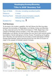
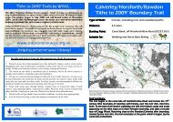
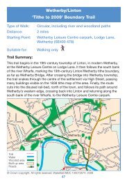
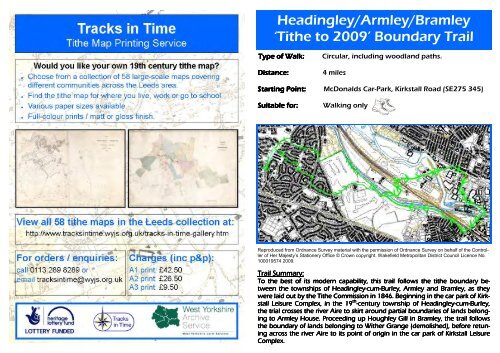
Head<strong>in</strong>gley/Armley/Bramley‘<strong>Ti<strong>the</strong></strong> <strong>to</strong> <strong>2009</strong>’ Boundary <strong>Trail</strong>Type of Walk: Circular, <strong>in</strong>clud<strong>in</strong>g woodland paths.Distance: 4 milesStart<strong>in</strong>g Po<strong>in</strong>t: McDonalds Car-Park, Kirkstall Road (SE275 345)Suitable for: Walk<strong>in</strong>g onlyReproduced from Ordnance Survey material with <strong>the</strong> permission of Ordnance Survey on behalf of <strong>the</strong> Controllerof Her Majesty’s Stationery Office © Crown copyright. Wakefield Metropolitan District Council Licence No.100019574 <strong>2009</strong>.<strong>Trail</strong> Summary:To <strong>the</strong> best of its modern capability, this trail follows <strong>the</strong> ti<strong>the</strong> boundary be-tween <strong>the</strong> <strong>to</strong>wnships of Head<strong>in</strong>gley-cumcum-Burley, Armley and Bramley, as <strong>the</strong>ywere laid out by <strong>the</strong> <strong>Ti<strong>the</strong></strong> Commission <strong>in</strong> 1846. Beg<strong>in</strong>n<strong>in</strong>g <strong>in</strong> <strong>the</strong> car park of Kirk-stall Leisure Complex, <strong>in</strong> <strong>the</strong> 19 th -century <strong>to</strong>wnship of Head<strong>in</strong>gley-cumcum-Burley,<strong>the</strong> trial crosses <strong>the</strong> river Aire <strong>to</strong> skirt around partial boundaries of lands belong-<strong>in</strong>g <strong>to</strong> Armley House. Proceed<strong>in</strong>g up Houghley Gill <strong>in</strong> Bramley, <strong>the</strong> trail follows<strong>the</strong> boundary of lands belong<strong>in</strong>g <strong>to</strong> Wi<strong>the</strong>r Grange (demolished), before retun-<strong>in</strong>g across <strong>the</strong> river Aire <strong>to</strong> its po<strong>in</strong>t of orig<strong>in</strong> <strong>in</strong> <strong>the</strong> car park of Kirkstall LeisureComplex.
DirectionsTo <strong>the</strong> best of its modern capability, this trail follows <strong>the</strong> ti<strong>the</strong> boundary between<strong>the</strong> <strong>to</strong>wnships of Armley and Bramley, as <strong>the</strong>y were laid out by <strong>the</strong> <strong>Ti<strong>the</strong></strong> Commis-sion <strong>in</strong> 1846. The walk starts <strong>in</strong> MacDonald’s car-park <strong>in</strong> Kirkstall Road, <strong>in</strong> <strong>the</strong> 19thcentury <strong>to</strong>wnship of Head<strong>in</strong>gley-cumcum-Burley.We beg<strong>in</strong> by go<strong>in</strong>g left across <strong>the</strong> car-park of Kirkstall Leisure Centre, beh<strong>in</strong>d Mac-Donalds, <strong>to</strong> cross <strong>the</strong> footbridge over <strong>the</strong> river Aire and ascend <strong>the</strong> steps <strong>in</strong><strong>to</strong> Ca-nal Road. We <strong>the</strong>n turn right, pass<strong>in</strong>g <strong>in</strong> front of Armley Mills.Yorkshire Ladies’ Council of Education Diary,1876 (WYL5045/12)In cross<strong>in</strong>g <strong>the</strong> river, we havepassed over <strong>the</strong> ti<strong>the</strong> boundary of19th century Head<strong>in</strong>gley-cum-Burley and <strong>in</strong><strong>to</strong> <strong>the</strong> <strong>to</strong>wnship ofArmley. Armley Mills appears on<strong>the</strong> 1846 ti<strong>the</strong> map of <strong>the</strong> Armleyarea, as a complex belong<strong>in</strong>g <strong>to</strong>John Gott, Esquire, eldest son of<strong>the</strong> late Benjam<strong>in</strong>. Benjam<strong>in</strong> Gott(1762 – 1840) was a prom<strong>in</strong>entclothier, who built his first fac<strong>to</strong>ry,Park Mill, at Bean Ing <strong>in</strong> 1792 (on<strong>the</strong> site of <strong>the</strong> Yorkshire Post build<strong>in</strong>g<strong>in</strong> <strong>the</strong> west of <strong>Leeds</strong> city centre).Park Mill was <strong>the</strong> biggestwoollen cloth fac<strong>to</strong>ry <strong>in</strong> Yorkshireand a huge enterprise at a time when <strong>the</strong>re were fewer than 20 mills of any sort <strong>in</strong><strong>Leeds</strong>. By 1797, Benjam<strong>in</strong> Gott was master of 1200 workers, and had amassed aconsiderable fortune. He purchased Armley Mills <strong>in</strong> 1800, <strong>in</strong> order <strong>to</strong> fur<strong>the</strong>r hisbus<strong>in</strong>ess, which he <strong>the</strong>n passed <strong>to</strong> his eldest son at his death.Armley Mills however, has been around a lot longer than <strong>the</strong> Gott family. The earliestrecord of Armley Mills dates from <strong>the</strong> middle of <strong>the</strong> 16th century when localclothier Richard Booth leased ‘Armley Millnes’ from Henry Saville. A document of1707 provides <strong>the</strong> first description of <strong>the</strong> mill and full<strong>in</strong>g process carried out <strong>the</strong>re.Full<strong>in</strong>g was <strong>the</strong> f<strong>in</strong>al stage <strong>in</strong> cloth production and <strong>in</strong>volved pound<strong>in</strong>g <strong>the</strong> cloth <strong>in</strong>large pits filled with water, ur<strong>in</strong>e, and fuller’s earth <strong>to</strong> matt <strong>the</strong> fibres <strong>to</strong>ge<strong>the</strong>r.Full<strong>in</strong>g was one of <strong>the</strong> first <strong>in</strong>dustrial processes <strong>to</strong> have purpose built premises.• The papers of <strong>the</strong> Gott family are held <strong>in</strong> Special Collections at <strong>the</strong> <strong>Leeds</strong>University Library (MS193 - bus<strong>in</strong>ess papers and MS194 - family papers).• West Yorkshire Archive Service also holds several collections with affiliation<strong>to</strong> <strong>the</strong> Gott family, such as <strong>the</strong> Yorkshire Ladies’ Council of EducationM<strong>in</strong>utes (WYL5045) and <strong>the</strong> records of <strong>the</strong> <strong>Leeds</strong> Association for <strong>the</strong> Protectionand Care of Young Girls (WYL416).
Take <strong>the</strong> next right <strong>in</strong><strong>to</strong> Armley Park Road and follow <strong>the</strong> road <strong>to</strong> <strong>the</strong> entrance ofArmley Park. Take <strong>the</strong> right hand path and go down <strong>the</strong> steps, follow<strong>in</strong>g <strong>the</strong> pathahead and keep<strong>in</strong>g <strong>the</strong> <strong>Leeds</strong> Liverpool canal on your right.Both <strong>the</strong> railway you have just passed by and <strong>the</strong> <strong>Leeds</strong> Liverpool Canal are listed<strong>in</strong> <strong>the</strong> Armley ti<strong>the</strong> apportionment of 1846 as simply belong<strong>in</strong>g <strong>to</strong> <strong>the</strong> <strong>Leeds</strong> andBradford Railway Company and <strong>to</strong> <strong>the</strong> <strong>Leeds</strong> Liverpool Canal Company respectively.The railway was not yet built <strong>in</strong> 1846 and is marked on <strong>the</strong> Armley ti<strong>the</strong> mapby an orange stripe, labelled ’land taken for railway’. However, <strong>the</strong> canal pre-dates<strong>the</strong> ti<strong>the</strong> map. The <strong>Leeds</strong> Liverpool was <strong>the</strong> first of <strong>the</strong> Trans Penn<strong>in</strong>e canals <strong>to</strong> bestarted, be<strong>in</strong>g proposed <strong>in</strong> 1765, and <strong>the</strong> last <strong>to</strong> be completed, <strong>in</strong> 1816. The lengthand complexity of <strong>the</strong> route meant <strong>the</strong> canal <strong>to</strong>ok 46 years <strong>to</strong> build at a cost of fivetimes <strong>the</strong> orig<strong>in</strong>al budget.Plan of Armley , 1846, WYAS <strong>Leeds</strong>, RD/RT10Cont<strong>in</strong>u<strong>in</strong>g on <strong>the</strong> path, you soon pass on your left, a Vic<strong>to</strong>rian folly of 156steps with an arch half way up, bear<strong>in</strong>g <strong>the</strong> date 1893.Vic<strong>to</strong>rian Folly 1883These steps do not feature on <strong>the</strong> Armley ti<strong>the</strong> map, as <strong>the</strong>yhad not yet been constructed <strong>in</strong> 1846. Armley Park was notacquired by <strong>the</strong> Corporation for <strong>the</strong> people of <strong>Leeds</strong> until1892, and <strong>in</strong> 1846, still belonged <strong>to</strong> John Gott Esq. The landhere is listed <strong>in</strong> <strong>the</strong> ti<strong>the</strong> apportionment as be<strong>in</strong>g ’parkland,woods, and pleasure ground’ associated with Armley House.Armley House was <strong>the</strong> family home of Benjam<strong>in</strong> Gott, his wifeElizabeth, and <strong>the</strong>ir children, 3 sons and a daughter. In 1846,Benjam<strong>in</strong>’s widow still lived here, despite <strong>the</strong> property belong<strong>in</strong>g<strong>to</strong> her eldest son, John, who resided at Wi<strong>the</strong>r Grange. OnElizabeth’s death, <strong>the</strong> 24 acres of parkland at Armley Housewere sold <strong>to</strong> <strong>the</strong> <strong>Leeds</strong> Corporation, and <strong>the</strong>se steps were built<strong>to</strong> create public access <strong>to</strong> <strong>the</strong> park up <strong>the</strong> steep slope from <strong>the</strong>canal side.Carry<strong>in</strong>g straight on ahead, you reach Redcote Bridge. The name Redcote is eviden<strong>to</strong>n <strong>the</strong> Armley ti<strong>the</strong> map of 1846, which shows build<strong>in</strong>gs here around bo<strong>the</strong>nds of <strong>the</strong> bridge. The build<strong>in</strong>gs on <strong>the</strong> opposite side of <strong>the</strong> bridge <strong>to</strong> where weare stand<strong>in</strong>g now, belonged <strong>to</strong> Sir Sandford Graham Baronet, and were leased <strong>to</strong>John Tattersall as a house, cottages, mistals and a yard. These were <strong>the</strong> build<strong>in</strong>gsknown as Redcote. On this side of <strong>the</strong> bridge, <strong>in</strong> <strong>the</strong> woods <strong>to</strong> your right, were twocottages with gardens leased by John Gott, Esq., <strong>to</strong> Mary and John Walker.• The <strong>Leeds</strong>-Liverpool Canal is a Site of Special Scientific Interest ow<strong>in</strong>g <strong>to</strong> itscalcium-rich, clay l<strong>in</strong><strong>in</strong>g, which encourages <strong>the</strong> growth of water plants. It isalso a favourite haunt for local anglers and otters due <strong>to</strong> an abundance of fish,<strong>in</strong>clud<strong>in</strong>g bream, roach, carp, and pike.• The records of <strong>the</strong> <strong>Leeds</strong> and Liverpool Canal Company (C299/16 andWYL7) and a list of subscribers <strong>to</strong> <strong>the</strong> <strong>Leeds</strong> and Bradford Railway(WYL13) are held by West Yorkshire Archive Service (WYAS).
Fac<strong>in</strong>g Redcote Bridge, follow <strong>the</strong> footpath <strong>to</strong> your left <strong>in</strong><strong>to</strong>Ridge Wood, keep<strong>in</strong>g <strong>the</strong> canal on your right.As you cont<strong>in</strong>ue along this path, see if you can spot <strong>the</strong> Armley/BramleyBoundary s<strong>to</strong>nes. There are two on your right on<strong>the</strong> slope beside <strong>the</strong> woodland path and one on <strong>the</strong> fairway of<strong>the</strong> golf course <strong>to</strong> your left. This one can be seen through aclear<strong>in</strong>g <strong>in</strong> <strong>the</strong> trees - it is not recommended that you walk on<strong>the</strong> fairway. The canal marks <strong>the</strong> Armley/Bramley boundary,Bramley be<strong>in</strong>g on <strong>the</strong> opposite side <strong>to</strong> where you are walk<strong>in</strong>g.Armley/Bramley BoundaryS<strong>to</strong>nePass through a small clear<strong>in</strong>g on <strong>the</strong> left and follow <strong>the</strong>path back <strong>in</strong><strong>to</strong> <strong>the</strong> woods for a short distance, untilyou are forced out on<strong>to</strong> <strong>the</strong> golf course. Turn right andgo straight on <strong>to</strong> <strong>the</strong> corner of <strong>the</strong> golf green, <strong>the</strong>nturn left up <strong>the</strong> edge of <strong>the</strong> course. Follow <strong>the</strong> l<strong>in</strong>e oftrees and <strong>the</strong> remnants of a boundary wall of ArmleyHouse on your left, right up <strong>the</strong> side of <strong>the</strong> golf course,climb<strong>in</strong>g a gentle hill until you reach <strong>the</strong> road at <strong>the</strong>Ridge Wood<strong>to</strong>p. Go out on<strong>to</strong> <strong>the</strong> footpath <strong>in</strong> Armley Ridge Road.Turn immediately <strong>to</strong> your right and follow <strong>the</strong> footpath till you reach Raynville Cres-cent on <strong>the</strong> opposite side of <strong>the</strong> road. Cross here and just <strong>in</strong>side Raynville Crescent, <strong>to</strong>your left, is <strong>the</strong> site of <strong>the</strong> house and stable block of Wi<strong>the</strong>r Grange, <strong>the</strong> residence ofJohn Gott Esq., eldest son of Benjam<strong>in</strong> Gott. The boundary wall separat<strong>in</strong>g <strong>the</strong> nextplot from John Gott’s residence still stands <strong>to</strong> your right.Wi<strong>the</strong>r Grange appears on <strong>the</strong> 1846 ti<strong>the</strong> map of Armley as a large complex conta<strong>in</strong><strong>in</strong>ga grand house and outbuild<strong>in</strong>gs. Dur<strong>in</strong>g <strong>the</strong> 1880s and 1890s it was leased byThomas Harrison, J.P. The house and grounds belonged <strong>to</strong> <strong>the</strong> Gott family until <strong>the</strong>First World War, dur<strong>in</strong>g which <strong>the</strong>y donated it <strong>to</strong> <strong>the</strong> war effort. The Wy<strong>the</strong>r Home forSick Babies opened <strong>in</strong> <strong>the</strong> build<strong>in</strong>g <strong>in</strong> 1914, and was described by <strong>the</strong> <strong>Leeds</strong> BabiesWelcome Association Annual Report as hav<strong>in</strong>g a ’beautiful garden, large rooms andfresh air…[assist<strong>in</strong>g recovery]’. By 1926, <strong>the</strong> medical officer for Wy<strong>the</strong>r Infants’ Hospitalwas Miss Norah F. Smith M.B.S.S.D.P.H. She was also <strong>the</strong> assistant medical officer formaternity and child welfare <strong>in</strong> <strong>Leeds</strong>. In <strong>the</strong> 1930s, <strong>the</strong> home became <strong>the</strong> City of<strong>Leeds</strong> Infants’ Hospital. Houses were eventually built on <strong>the</strong> site of Wi<strong>the</strong>r Grange <strong>in</strong>1990. The spell<strong>in</strong>g of ‘Wi<strong>the</strong>r’ seems <strong>to</strong> have acquired a ’y’ <strong>in</strong> place of <strong>the</strong> ’i’ for unknownreasons dur<strong>in</strong>g <strong>the</strong> 20th century. Perhaps it was thought <strong>to</strong> look more qua<strong>in</strong>tand archaic!• Ridge Wood has a canopy of trees <strong>in</strong>clud<strong>in</strong>g sessile oak, elm, ash, silver birch,beech, sycamore, and hornbeam. Beneath this is a shrub layer of elder, hawthorn,hazel, holly, dogwood, willow and guilder rose. In <strong>the</strong> spr<strong>in</strong>g, <strong>the</strong> groundhas a carpet of wild garlic, which gives <strong>the</strong> wood its <strong>in</strong>terest<strong>in</strong>g smell, as wellas bluebells, wood avens, enchanter’s nightshade, lesser celand<strong>in</strong>e, and ladyfern.On reach<strong>in</strong>g <strong>the</strong> front corner of <strong>the</strong> house ignore <strong>the</strong> path that turns sharp right <strong>to</strong>go across its grand frontage. Cont<strong>in</strong>ue <strong>in</strong>stead down <strong>the</strong> path ahead of you and fol-low its gentle curve around <strong>the</strong> edge of <strong>the</strong> lawn <strong>to</strong> your right keep<strong>in</strong>g <strong>the</strong> woods onyour left. At <strong>the</strong> corner of <strong>the</strong> lawn, ignore <strong>the</strong> path’s right turn and follow <strong>in</strong>stead<strong>the</strong> path ahead and slightly <strong>to</strong> your left as it beg<strong>in</strong>s its steep descent <strong>in</strong> <strong>to</strong> RidgeWood. Shortly, you will come <strong>to</strong> a set of steps with a solid wooden handrail. Descend<strong>the</strong> steps and at <strong>the</strong> bot<strong>to</strong>m take <strong>the</strong> rough path straight ahead of you. This path canbe wet and muddy <strong>in</strong> places.Shortly, <strong>the</strong> rough path turns suddenly and sharply <strong>to</strong> <strong>the</strong>left down a very steep slope. Descend this slope andwhere <strong>the</strong> path splits at <strong>the</strong> bot<strong>to</strong>m, we arrive back atRedcoteBridge.Cross over <strong>the</strong>bridge, and directlyahead of you is Kirk-stall power station.Look<strong>in</strong>g <strong>to</strong>wards Redcote Bridgefrom Ridge WoodTurn right and fol-low <strong>the</strong> access laneround under <strong>the</strong> railway bridge. Keep<strong>in</strong>g right,you will soon emerge <strong>in</strong><strong>to</strong> Kirkstall Road. Turnright aga<strong>in</strong>, and after a short walk, arrive back at<strong>the</strong> car-park of Kirkstall Leisure Complex.Redcote Bridge• There is a very large beech tree as you enter Ridge Wood. It is 140 cm (56<strong>in</strong>ches) <strong>in</strong> diameter at breast height (DBH) and may be 300 years old.Health and Safety/General Information for Walk Participants1. Please be aware that ti<strong>the</strong> boundaries are often def<strong>in</strong>ed by features such as rivers, becks,dilapidated walls, and wooded areas. Footpaths <strong>in</strong> <strong>the</strong>se areas may be wet, steep, uneven, ormuddy. Walkers are <strong>the</strong>refore advised <strong>to</strong> wear strong, waterproof footwear.2. The terra<strong>in</strong> on our walks is considered easy <strong>to</strong> moderate, but for <strong>the</strong> above reasons, ispartially <strong>in</strong>accessible <strong>to</strong> wheelchair users and pushchairs.3. All ages are welcome and encouraged <strong>to</strong> take part <strong>in</strong> our walks. However, we ask you <strong>to</strong>be aware that paths can sometimes be steep, uneven, and run very close <strong>to</strong> water. Some walkroutes also use steps and cross busy roads. For <strong>the</strong>se reasons, no unaccompanied children arepermitted. Children are deemed <strong>to</strong> be persons under <strong>the</strong> age of 18 years.4. Some walk routes pass through densely wooded areas or around <strong>the</strong> edges of golfcourses, us<strong>in</strong>g unmarked public and permissive paths. Please be aware of your own personalsafety and that of anybody <strong>in</strong> your care. Please do not deviate from planned routes.5. Walks will go ahead <strong>in</strong> most wea<strong>the</strong>r conditions, so please dress appropriately.6. You are advised <strong>to</strong> br<strong>in</strong>g a snack and adequate refreshment on all walks.
Most of <strong>the</strong> houses and farm build<strong>in</strong>gs of Armley Ridge,which were rented <strong>to</strong> Chris<strong>to</strong>pher Acroyd and o<strong>the</strong>rsby John Gott, Esq <strong>in</strong> 1846 are now gone. However twocottages, nos. 181 and 183, rema<strong>in</strong>, fac<strong>in</strong>g <strong>in</strong><strong>to</strong> ArmleyRidge Road. There is also a 19th century boundary wallstill runn<strong>in</strong>g across <strong>the</strong> fronts of <strong>the</strong>se cottages.Nos. 181 and 183 Armley Ridge RdCross Armley Ridge Road from <strong>the</strong> corner of Gotts ParkAvenue. Enter Gotts Park through <strong>the</strong> gateway imme-diately ahead.Just <strong>in</strong>side <strong>the</strong> gate and <strong>to</strong> your right is a build<strong>in</strong>g nowknown as The Lodge. This and a few build<strong>in</strong>gs beh<strong>in</strong>dit are all that rema<strong>in</strong>s of <strong>the</strong> extensive outbuild<strong>in</strong>gs, stableyard and gardener’s house associated with ArmleyHouse, that <strong>the</strong> 1846 ti<strong>the</strong> map records stand<strong>in</strong>g here.However, <strong>in</strong> front of The Lodge, a large cross of Celticdesign, recalls <strong>the</strong> erection of alms houses on <strong>the</strong> samespot, by Benjam<strong>in</strong> Gott, <strong>in</strong> 1823. These were endowedby Gott’s daughter, Harriet and <strong>the</strong> cross raised <strong>in</strong> <strong>the</strong>irmemory by W H Gott <strong>in</strong> 1902. It is not clear whe<strong>the</strong>r,The Lodgeby 1846, <strong>the</strong> Gott family had employed <strong>the</strong> poor of <strong>the</strong>ir almshouses as gardeners <strong>to</strong><strong>the</strong> estate, or if <strong>the</strong> almshouses here had simply changed use. Ei<strong>the</strong>r way, no reference<strong>to</strong> <strong>the</strong>ir use as alms houses is made <strong>in</strong> <strong>the</strong> ti<strong>the</strong> apportionment.(If you are s<strong>to</strong>pp<strong>in</strong>g for lunch <strong>the</strong> walled garden still <strong>in</strong> existence <strong>to</strong> <strong>the</strong> left of TheLodge makes a lovely spot. and can be accessed by walk<strong>in</strong>g around its left hand edge.)Follow <strong>the</strong> path opposite <strong>the</strong> front of The Lodge <strong>to</strong>wards Armley House not<strong>in</strong>g <strong>the</strong>views of <strong>Leeds</strong> city centre <strong>to</strong> your left. Keep<strong>in</strong>g left when <strong>the</strong> path splits, go around <strong>the</strong>left hand side of <strong>the</strong> build<strong>in</strong>g. We have actually approached Armley House from <strong>the</strong>back as its grand frontage faced <strong>to</strong>wards <strong>the</strong> <strong>Leeds</strong>/Liverpool canal and Armley Mills,<strong>the</strong> second fac<strong>to</strong>ry purchased by its prosper<strong>in</strong>g owner Benjam<strong>in</strong> Gott, <strong>in</strong> 1800.As you round <strong>the</strong> end of <strong>the</strong> house, you will notice<strong>the</strong> dilapidated rema<strong>in</strong>s of a semi-circular structure <strong>to</strong>your right. This structure appears on <strong>the</strong> ti<strong>the</strong> map of1846 and marks <strong>the</strong> extent of <strong>the</strong> orig<strong>in</strong>al build<strong>in</strong>g, aneo-classical villa with w<strong>in</strong>gs out ei<strong>the</strong>r side. ArmleyHouse was first built <strong>in</strong> 1718 by a local merchant, butafter be<strong>in</strong>g purchased by Benjam<strong>in</strong> Gott <strong>in</strong> 1803,was redesigned <strong>in</strong> 1822 by Sir Robert Smirk architect<strong>to</strong> <strong>the</strong> British Museum. The w<strong>in</strong>gs of Armley Housewere demolished <strong>in</strong> <strong>the</strong> 1970s. The semi-circularArmley House - grand frontagestructure <strong>to</strong> your right may once have been a conserva<strong>to</strong>ryor a small orangery fac<strong>in</strong>g out over <strong>the</strong> park and woodland.Sister Palmer and nurses on <strong>the</strong> lawn of Wy<strong>the</strong>r Home for Sick Babies, c.1914, and <strong>the</strong> open<strong>in</strong>g of Armley Babies’Welcome, 1928. (WYL705/20)Cont<strong>in</strong>ue up Raynville Crescent, follow<strong>in</strong>g <strong>the</strong> road round <strong>to</strong> <strong>the</strong> right and ignor<strong>in</strong>gany turn-offs until you reach Raynville Gardens on your right. Here turn left andcross Raynville Crescent <strong>to</strong> enter Houghley Gill on <strong>the</strong> opposite side of <strong>the</strong> road,through <strong>the</strong> black gate. Walk up <strong>the</strong> path ahead and pass through a green gate <strong>in</strong><strong>to</strong><strong>the</strong> wooded part of <strong>the</strong> Gill. Pass four sets of steps lead<strong>in</strong>g out of <strong>the</strong> Gill on yourright. Shortly after <strong>the</strong> fourth set of steps, you cross over <strong>the</strong> <strong>in</strong>visible ti<strong>the</strong> boundaryof 1846 <strong>in</strong><strong>to</strong> <strong>the</strong> 19th century <strong>to</strong>wnship of Bramley. Follow <strong>the</strong> Gill until you reach<strong>the</strong> green gate at Bramley Hill Top. Go through <strong>the</strong> gate and turn back <strong>to</strong> face it.Houghley Gill - look<strong>in</strong>g <strong>to</strong>wards Hill TopStand<strong>in</strong>g at <strong>the</strong> entrance <strong>to</strong> Houghley Gill <strong>in</strong>Bramley look <strong>to</strong> <strong>the</strong> right over your shoulder. Setabove you on a ridge beh<strong>in</strong>d trees you will notesome ra<strong>the</strong>r ancient properties, dat<strong>in</strong>g from <strong>the</strong>medieval and Elizabethan periods. This area isknown locally as Hill Top. Accord<strong>in</strong>g <strong>to</strong> <strong>the</strong> Bramleyti<strong>the</strong> apportionment of 1846, <strong>the</strong> Cottageswere owned and occupied <strong>the</strong>n by Julius Popplewelland Joseph Hargrave, who had a house, ahomestead, and an orchard <strong>the</strong>re. The Hill Toparea of Bramley is now a Conservation Area andhas changed very little s<strong>in</strong>ce <strong>the</strong> Vic<strong>to</strong>rian ti<strong>the</strong>map was drawn. The cottages here stand on <strong>the</strong>same footpr<strong>in</strong>ts as <strong>the</strong> build<strong>in</strong>gs appear<strong>in</strong>g on<strong>the</strong> ti<strong>the</strong> map, and from <strong>the</strong>ir age, are certa<strong>in</strong>ly<strong>the</strong> same build<strong>in</strong>gs, hav<strong>in</strong>g been simply extendedor adapted <strong>in</strong> areas.• At night, <strong>the</strong> trees <strong>in</strong> Houghley Gill are a perfect feed<strong>in</strong>g ground for bats.There are records of Pipistrelle bats roost<strong>in</strong>g <strong>in</strong> nearby houses and some batboxes on an Italian Alder tree. Can you f<strong>in</strong>d <strong>the</strong> bats carved on <strong>the</strong> gatepostsof <strong>the</strong> Gill? On <strong>the</strong> ground, garlic mustard and st<strong>in</strong>g<strong>in</strong>g nettles are food plantsfor orange tip, peacock and small <strong>to</strong>r<strong>to</strong>iseshell butterflies. Foxes, grey squirrels,and roe deer have also been spotted here, early <strong>in</strong> <strong>the</strong> morn<strong>in</strong>g.
Entrance <strong>to</strong> Hill Top Commercial Centre, <strong>the</strong> road lead<strong>in</strong>g <strong>to</strong> <strong>the</strong> Tan Pits,and remnants of <strong>the</strong> wall surround<strong>in</strong>g <strong>the</strong> house of Richard Nichols.On <strong>the</strong> left, <strong>in</strong> front of where<strong>the</strong> wall now stands, <strong>the</strong>ti<strong>the</strong> map clearly shows apond and a beck flow<strong>in</strong>gdown <strong>in</strong><strong>to</strong> <strong>the</strong> wooded areaof Houghley Gill. In 1846this beck likely served <strong>the</strong>houses on Hill Top and <strong>the</strong>Tan Pits, owned by RichardNichols, which s<strong>to</strong>od highabove <strong>the</strong> Gill, on <strong>the</strong> site ofHill Top Commercial Centre.The trees and beck <strong>in</strong>Houghley Gill would havebeen essential <strong>to</strong> any lea<strong>the</strong>rtann<strong>in</strong>g tak<strong>in</strong>g place <strong>in</strong> <strong>the</strong>area as both tree bark andwater were used extensively <strong>in</strong> this process. The tan pits referenced by <strong>the</strong> ti<strong>the</strong> mapwould have been filled with crushed bark and water, or ‘tan liquor’, <strong>the</strong> solution gett<strong>in</strong>gprogressively stronger <strong>in</strong> each pit . Animal sk<strong>in</strong>s were immersed <strong>in</strong> <strong>the</strong> pits <strong>to</strong>slowly absorb this ‘liquor’ and could take up <strong>to</strong> 2 years <strong>to</strong> tan. The entrance <strong>to</strong> Hill TopCommercial Centre where build<strong>in</strong>gs associated with <strong>the</strong> tan pits s<strong>to</strong>od, can be seen onyour left. Richard Nichols lived <strong>in</strong> a house with stables, gardens, and an orchard, justbeh<strong>in</strong>d this road, on <strong>the</strong> spot where <strong>the</strong> new houses stand. The old wall here may be<strong>the</strong> same wall that surrounded Nichols’ house.Walk back between <strong>the</strong> gate posts of Houghley Gill now and cont<strong>in</strong>ue straight ahead,follow<strong>in</strong>g <strong>the</strong> footpath. In 1846 this footpath existed beside <strong>the</strong> beck shown on <strong>the</strong>ti<strong>the</strong> map and follows more or less <strong>the</strong> same course as <strong>the</strong> water, which is now pipedunderground. The beck would have been on your left as you walk down <strong>the</strong> footpath,and if you listen carefully you can still hear it flow<strong>in</strong>g along its pipe.This stretch of Houghley Gill was knownas Gill Wood and was owned by JohnGott, Esq. as part of <strong>the</strong> Wy<strong>the</strong>r Grangeestate. Accord<strong>in</strong>g <strong>to</strong> <strong>the</strong> ti<strong>the</strong> boundaryof 1846, we rema<strong>in</strong> <strong>in</strong> Bramley <strong>to</strong>wnshipas we walk through <strong>the</strong> Gill with <strong>the</strong>boundary of Wi<strong>the</strong>r Grange, <strong>in</strong> Armley<strong>to</strong>wnship, constantly visible at <strong>the</strong> <strong>to</strong>p of<strong>the</strong> steep slope <strong>to</strong> our right. Where wereach <strong>the</strong> term<strong>in</strong>ation of <strong>the</strong> wall enclos<strong>in</strong>gHill Top Commercial Centre on ourleft hand side, here imag<strong>in</strong>e an <strong>in</strong>visiblel<strong>in</strong>e across <strong>the</strong> footpath <strong>in</strong> front of you.This is <strong>the</strong> po<strong>in</strong>t at which we cross <strong>the</strong>Houghley Gillti<strong>the</strong> boundary and re-enter <strong>the</strong> 19th century <strong>to</strong>wnship of Armley. At this po<strong>in</strong>t,Houghley Gill, still owned by John Gott Esq., was known as Oflay Bank. The twonames, Gill Wood and Oflay Bank, must eventually have merged <strong>to</strong> become Oflay(or Houghley) Gill.After pass<strong>in</strong>g two sets of steps ris<strong>in</strong>g out of Houghley Gillon your left, immediately before a third, <strong>the</strong>re are a s<strong>in</strong>gleset of ra<strong>the</strong>r dilapidated steps lead<strong>in</strong>g up <strong>the</strong> steep slope<strong>to</strong> your right. Turn right and go up <strong>the</strong>se steps <strong>to</strong> <strong>the</strong> <strong>to</strong>pof <strong>the</strong> slope, emerg<strong>in</strong>g through a modern stile <strong>in</strong><strong>to</strong> a g<strong>in</strong>nel.Follow this g<strong>in</strong>nel round <strong>to</strong> <strong>the</strong> left and <strong>in</strong><strong>to</strong> Cover-dale Close. Coverdale Close is built <strong>in</strong>side <strong>the</strong> boundary of<strong>the</strong> lands of Wi<strong>the</strong>r Grange, now demolished, and wouldhave been <strong>in</strong> Armley <strong>to</strong>wnship <strong>in</strong> 1846.Walk straight ahead <strong>to</strong> <strong>the</strong> end of <strong>the</strong> short road, turn<strong>in</strong>g right <strong>in</strong><strong>to</strong> Coverdale Cres-cent and follow <strong>the</strong> footpath on <strong>to</strong> <strong>the</strong> road side, as it curves <strong>to</strong> <strong>the</strong> right. Where <strong>the</strong>road forks, go left, and cont<strong>in</strong>ue across <strong>the</strong> 19th century lands of Wi<strong>the</strong>r Grange, byhead<strong>in</strong>g through <strong>the</strong> kiss<strong>in</strong>g gate at <strong>the</strong> end of <strong>the</strong> road. Follow <strong>the</strong> path <strong>to</strong> <strong>the</strong>right up <strong>the</strong> hill, ignor<strong>in</strong>g m<strong>in</strong>or turn-offs. When <strong>the</strong> ma<strong>in</strong> path splits, take <strong>the</strong> rightfork and climb <strong>the</strong> hill until you reach ano<strong>the</strong>r gate, open<strong>in</strong>g on<strong>to</strong> Wy<strong>the</strong>r Park Hill.Turn left out of this gate and head down Wy<strong>the</strong>r Park Hill, keep<strong>in</strong>g <strong>to</strong> <strong>the</strong> footpathon <strong>the</strong> left side of <strong>the</strong> road.(Note <strong>the</strong> views of <strong>Leeds</strong> City centre <strong>to</strong> your left, and KirkstallAbbey, left and slightly beh<strong>in</strong>d you).The boundary of Wi<strong>the</strong>r Grange<strong>in</strong> Armley <strong>to</strong>wnship.Wy<strong>the</strong>r Park Hill follows, as well as possible, <strong>the</strong> Vic<strong>to</strong>rianti<strong>the</strong> boundary between Armley and Bramley <strong>to</strong>wnships,skirt<strong>in</strong>g <strong>the</strong> edge of <strong>the</strong> lands of Wi<strong>the</strong>r Grange, <strong>the</strong> 1846View from Wy<strong>the</strong>r Park Hillresidence of John Gott, Esq. Wy<strong>the</strong>r House itself would been visible <strong>in</strong> <strong>the</strong> 19th centuryfrom a position about half way down Wy<strong>the</strong>r Park Hill. The house would havebeen some distance <strong>to</strong> your left and surrounded thickly by trees. With <strong>the</strong> housewere stables, outbuild<strong>in</strong>gs and pleasure grounds. The footpr<strong>in</strong>t of <strong>the</strong> new estate ofred brick houses, low on your left hand side, marks <strong>the</strong> boundary of <strong>the</strong> landscapedpark around John Gott Esq.’s great house.Reach<strong>in</strong>g <strong>the</strong> end of Wy<strong>the</strong>r Park Hill and <strong>the</strong> junction with Cockshott Lane, crossCockshott Lane and walk up <strong>the</strong> hill, turn<strong>in</strong>g left <strong>in</strong><strong>to</strong> Gotts Park Avenue. Cont<strong>in</strong>uealong Gotts Park Avenue, cross<strong>in</strong>g two m<strong>in</strong>or roads.The name ‘Gotts Park Avenue’ may suggest <strong>the</strong>se lands once belonged <strong>to</strong> Gotts Parkor <strong>to</strong> Armley House, as <strong>the</strong> estate was known <strong>in</strong> <strong>the</strong> 19th century. Accord<strong>in</strong>g <strong>to</strong> <strong>the</strong>ti<strong>the</strong> map however <strong>the</strong> lands here belonged <strong>to</strong> Armley Ridge, a group of sevenhouses and farm build<strong>in</strong>gs which s<strong>to</strong>od <strong>to</strong> your left hand side as you reach what isnow <strong>the</strong> junction between Gotts Park Avenue and Armley Ridge Road. We’ll s<strong>to</strong>phere for a moment.