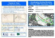
Download Tithe to 2009 Trail - Tracks in Time, the Leeds Tithe Map ...
Download Tithe to 2009 Trail - Tracks in Time, the Leeds Tithe Map ...
Download Tithe to 2009 Trail - Tracks in Time, the Leeds Tithe Map ...

You also want an ePaper? Increase the reach of your titles
YUMPU automatically turns print PDFs into web optimized ePapers that Google loves.
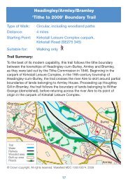
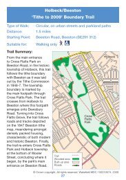
DirectionsFrom <strong>the</strong> park<strong>in</strong>g areaat <strong>the</strong> canal side offHorsforth New Road,turn right and follow<strong>the</strong> road ahead, ignor-<strong>in</strong>g <strong>the</strong> canal <strong>to</strong>wpath<strong>to</strong> your left. Pass <strong>in</strong>front of a row of 19 thcentury cottages onyour right hand side,and s<strong>to</strong>p here for amoment. The closest of<strong>the</strong>se cottages <strong>to</strong> <strong>the</strong>road stands on <strong>the</strong> siteof build<strong>in</strong>gs shown on<strong>the</strong> Calverley with Farsleyti<strong>the</strong> map of 1846.This was plot number1095, owned by WalterS<strong>to</strong>tt Stanhope Esq.,and ra<strong>the</strong>r unfitt<strong>in</strong>glynamed, Lime Kiln Close.The plot was occupiedb y W i l l i a mEdmondson, who hada pasture and outb u i l d i n g s t h e r e ,though its name maysuggest <strong>the</strong> area hadpreviously had differentuses. Walter S<strong>to</strong>ttStanhope was affiliatedwith <strong>the</strong> Spencer Stanhopes,a wealthylanded family who hadresided at HorsforthPlan of Calverley with Farsley , 1846, WYAS <strong>Leeds</strong>, BD51Hall (demolished – site<strong>in</strong> Hall Park) s<strong>in</strong>ce <strong>the</strong> 18 th century, and previously at Low Hall. The S<strong>to</strong>tt Stanhopebranch of this family had <strong>the</strong>ir ancestral seat at Eccleshill Park <strong>in</strong> <strong>the</strong> modern district ofBradford.Walk on a little fur<strong>the</strong>r down <strong>the</strong> road and on your left hand side, notice a new block offlats, named Canal House. On <strong>the</strong> site of Canal House, <strong>the</strong> Calverley ti<strong>the</strong> map shows a• The S<strong>to</strong>tt Stanhope of Eccleshill Park Family and Estate Archive 1473—1929(STST, MM39, MM40, and MM45-48), is held by West Yorkshire ArchiveService.Walk until <strong>the</strong> track emerges beside <strong>the</strong> entrance <strong>to</strong> Woodbot<strong>to</strong>m Farm on your left.Ignor<strong>in</strong>g turn offs <strong>to</strong> your left and right, proceedstraight ahead, on<strong>to</strong> <strong>the</strong> rough road before you,and cont<strong>in</strong>ue <strong>to</strong> <strong>the</strong> junction. At <strong>the</strong> junction, ig-nore turns <strong>to</strong> <strong>the</strong> left and right, cross<strong>in</strong>g straigh<strong>to</strong>ver <strong>the</strong> stream <strong>to</strong> pass Woodbot<strong>to</strong>m Mills on yourleft.Just after Woodbot<strong>to</strong>m Mills, go around <strong>to</strong> <strong>the</strong> rightand jo<strong>in</strong> <strong>the</strong> footpath on <strong>the</strong> right hand side of LowHall Road, pass<strong>in</strong>g a set of white metal gates.Walk straight along Low Hall Road, keep<strong>in</strong>g <strong>the</strong>chemical plant on your right, until you reach <strong>the</strong>junction with Calverley Lane. Low Hall is across <strong>the</strong>road <strong>to</strong> your left.View of <strong>the</strong> Aire Valley over <strong>the</strong> track wallGo around <strong>the</strong> corner <strong>to</strong> your right, <strong>in</strong><strong>to</strong> Calverley Lane. Follow Calverley Lane down-hill, past <strong>the</strong> chemical plant on your right and over <strong>the</strong> railway bridge. Where <strong>the</strong> roadsweeps left at <strong>the</strong> bot<strong>to</strong>m of <strong>the</strong> hill, step down on<strong>to</strong> a dirt track lead<strong>in</strong>g off <strong>to</strong> yourright. Meet with cobbles and follow <strong>the</strong>m straight ahead, ignor<strong>in</strong>g turn-offs <strong>to</strong> <strong>the</strong> leftand right, and proceed across Calverley Bridge <strong>in</strong> front of you.After <strong>the</strong> bridge, turn left up a rough road, climb<strong>in</strong>g a gentle hill, and emerge from awooded avenue outside <strong>the</strong> Railway Public House, on your left. (For thirsty walkerswho deserve a reward, this is a lovely spot <strong>to</strong> s<strong>to</strong>p and re-fuel! The Railway has a beergarden for warm days, a playground for children, and will provide water for dogs.)Hav<strong>in</strong>g passed <strong>the</strong> public house, walk back up <strong>the</strong> road ahead of you <strong>to</strong> <strong>the</strong> park<strong>in</strong>garea opposite <strong>the</strong> canal <strong>to</strong> complete <strong>the</strong> walk.• Through <strong>the</strong> gates <strong>to</strong> your right is an old wildflower meadow. 19th and 2oth centuryagricultural improvement and spray<strong>in</strong>g with herbicide has meant <strong>the</strong>se havebecome ra<strong>the</strong>r rare. The meadow here has not been managed for many years, butstill conta<strong>in</strong>s a rich variety of plants <strong>in</strong>clud<strong>in</strong>g black knapweed, musk mallow,lady’s bedstraw (used <strong>to</strong> make pillows and mattresses smell nice <strong>in</strong> <strong>the</strong> past), ribwortplanta<strong>in</strong>, yarrow, crossword, birdsfoot trefoil, black medick, commonmouse-ear, dandelion, cut-leaved cranesbill, cocksfoot and Yorkshire fog.• The <strong>Leeds</strong>-Liverpool Canal is a Site of Special Scientific Interest ow<strong>in</strong>g <strong>to</strong> itscalcium-rich, clay l<strong>in</strong><strong>in</strong>g, which encourages <strong>the</strong> growth of an abundance of waterplants. On <strong>the</strong> opposite bank of <strong>the</strong> canal <strong>to</strong> where you are now walk<strong>in</strong>g, <strong>the</strong>re is alarge stand of flower<strong>in</strong>g rush, which exhibits a cluster of p<strong>in</strong>k blooms <strong>in</strong> lateJune. This is mixed <strong>in</strong><strong>to</strong> a bed of reed canary-grass and reed sweet-grass. On <strong>the</strong>nearside wall of <strong>the</strong> canal <strong>the</strong>re are blue flowers of skullcap and meadow sweet.Look out for dragonflies, which <strong>the</strong> canal provides a perfect environment for. Aswell as common blue and blue-tailed damselflies, <strong>the</strong> banded demoiselle, whichhas black bands on its w<strong>in</strong>gs, has been spotted here.
little way <strong>in</strong><strong>to</strong> Low Hall Road, stands <strong>the</strong> ancient build<strong>in</strong>g that gives <strong>the</strong> road its name.On <strong>the</strong> Horsforth ti<strong>the</strong> map of 1838, Low Hall is listed simply as a house, homestead,fold, and garden, owned by J.S. Stanhope Esq. and occupied by Daniel Ill<strong>in</strong>gworth. LowHall (also known as Calverley Old Hall) was <strong>the</strong> ancient seat of <strong>the</strong> Calverley family, whohad been prom<strong>in</strong>ent and wealthy local landowners s<strong>in</strong>ce early medieval times. The estatepassed <strong>to</strong> <strong>the</strong> Stanhopes after <strong>the</strong> Calverleys relocated <strong>to</strong> Esholt Hall <strong>in</strong> <strong>the</strong> 17 th century.Low Hall is thought <strong>to</strong> be one of <strong>the</strong> best preserved medieval manor houses <strong>in</strong> WestYorkshire, hav<strong>in</strong>g been divided <strong>in</strong><strong>to</strong> several dwell<strong>in</strong>gs after <strong>the</strong> departure of <strong>the</strong> Stanhopesfor Horsforth Hall <strong>in</strong> <strong>the</strong> early 18 th century, and eventually, <strong>to</strong> Cannon Hall <strong>in</strong>Cawthorne. The build<strong>in</strong>g’s division meant it escaped Vic<strong>to</strong>rian ‘modernisation’ as agrand villa, and rema<strong>in</strong>s true <strong>to</strong> its medieval form. The oldest part of <strong>the</strong> structure is <strong>the</strong>‘Solar’ with its gable end fac<strong>in</strong>g <strong>in</strong><strong>to</strong> Low Hall Road, and dates from around 1380.Cont<strong>in</strong>ue ahead down Low Hall Road. Just after Low Hall barn, on your right, standsLow Hall Farm House. This build<strong>in</strong>g also features on <strong>the</strong> Horsforth ti<strong>the</strong> map and <strong>in</strong>1838, was likewise owned by J.S. Stanhope Esq. Low Hall Farm is listed <strong>in</strong> <strong>the</strong> apportionmentas a house, folds, stack yards and plantation, occupied by Gaunt, Thompson, andCompany.Walk along Low Hall Road until it curves <strong>to</strong> <strong>the</strong> left, and <strong>the</strong>footpath ceases. Here, follow <strong>the</strong> road round <strong>to</strong> <strong>the</strong> left andpass <strong>in</strong> front of Wood Bot<strong>to</strong>m Mills on your right. The unitsstand<strong>in</strong>g here now are heavily adapted from those occupy<strong>in</strong>gthis identically named site <strong>in</strong> 1838. Accord<strong>in</strong>g <strong>to</strong> <strong>the</strong> Horsforthti<strong>the</strong> map, <strong>the</strong> build<strong>in</strong>gs mak<strong>in</strong>g up Wood Bot<strong>to</strong>m Mills at thistime consisted of works and a dam. Aga<strong>in</strong>, <strong>the</strong>se were ownedby J.S.Stanhope Esq., and were leased <strong>to</strong> <strong>the</strong> same Gaunt,Thompson, and Company, who occupied Low Hall Farm.Wood Bot<strong>to</strong>m Mills were engaged <strong>in</strong> woollen cloth manufacture.Woodbot<strong>to</strong>m MillsPass Wood Bot<strong>to</strong>m Mills, cross<strong>in</strong>g over a stream ahead. Where <strong>the</strong> road splits beforeyou, ignore <strong>the</strong> track lead<strong>in</strong>g <strong>to</strong> your right and follow <strong>in</strong>stead <strong>the</strong> rough road directlyahead. In cross<strong>in</strong>g over <strong>the</strong> stream, you have now passed over a second 19 th centuryti<strong>the</strong> boundary, between <strong>the</strong> <strong>to</strong>wnships of Horsforth and Rawdon.• A notice <strong>to</strong> quit regard<strong>in</strong>g <strong>the</strong> tenancy of Daniel Ill<strong>in</strong>gworth at Low Hall(SpSt/5/11/38) is held with<strong>in</strong> <strong>the</strong> Spencer Sranhope of Horsforth Family and EstateArchive (SpSt) at West Yorkshire Archive Service.• A Letter from John Stanhope <strong>to</strong> his bro<strong>the</strong>r Mr Stanhope of <strong>Leeds</strong>, merchant(SpSt/5/2/74) and Letters from Thomas Potts of Cannon Hall <strong>to</strong> John SpencerStanhope (SpSt/5/2/104) concern<strong>in</strong>g <strong>the</strong> lett<strong>in</strong>g of Woodhall Farm and <strong>the</strong> ‘badstate’ of Horsforth are also held with<strong>in</strong> <strong>the</strong> Spencer Sranhope of Horsforth Familyand Estate Archive (SpSt) at WYAS.• As you cross <strong>the</strong> stream, notice <strong>the</strong> wall on your right. It has colonised with a richmixture of plants, <strong>in</strong>clud<strong>in</strong>g maidenhair spleenwort and hart’s-<strong>to</strong>ngue fern, malefern, bit<strong>in</strong>g s<strong>to</strong>necrop, herb Robert and broad-leaved willow herb.Cont<strong>in</strong>ue ahead <strong>in</strong><strong>to</strong> Rawdon <strong>to</strong>wnship, until you pass <strong>in</strong> front of two modern houses.Beh<strong>in</strong>d <strong>the</strong>se houses, <strong>to</strong> your left, lies <strong>the</strong> site of Rawdon Low Mill, <strong>the</strong> chimney ofwhich is visible above <strong>the</strong> roof<strong>to</strong>ps. Low Mill was orig<strong>in</strong>ally built <strong>in</strong> 1797, and was <strong>the</strong>first of three mills, <strong>the</strong> o<strong>the</strong>rs be<strong>in</strong>g Park Mill (1805) and Larkfield Mill (1825), <strong>to</strong> beerected by <strong>the</strong> Thompson family <strong>in</strong> Rawdon. Parts of <strong>the</strong> orig<strong>in</strong>al mill build<strong>in</strong>gs and damat Low Mill, evident on <strong>the</strong> Rawdon ti<strong>the</strong> map of 1838, are still stand<strong>in</strong>g. The structureswere listed <strong>in</strong> <strong>the</strong> ti<strong>the</strong> apportionment as Rawdon Lane Mill, dam, and gardens, belong<strong>in</strong>g<strong>to</strong> Ephraim Elsworth, and leased <strong>to</strong> J.R. Thompson. The bus<strong>in</strong>ess conducted herewas likely <strong>to</strong> be one of <strong>the</strong> early stages <strong>in</strong> woollen cloth manufacture such as scribbl<strong>in</strong>g,comb<strong>in</strong>g, and slubb<strong>in</strong>g, which <strong>in</strong>volved wash<strong>in</strong>g and straighten<strong>in</strong>g <strong>the</strong> fibres of <strong>the</strong>wool. From your current position, over your right shoulder, you will also be able <strong>to</strong> seeRawdon Low Mill Methodist Chapel, now a private residence. This chapel does not appearon <strong>the</strong> Rawdon ti<strong>the</strong> map as it did not open <strong>in</strong> service of <strong>the</strong> Low Mill workforceuntil 1881.Walk<strong>in</strong>g straight ahead until <strong>the</strong> road splits aga<strong>in</strong>, pause for a moment. Down <strong>the</strong>rough road <strong>to</strong> your left some post-1838 Vic<strong>to</strong>rian additions <strong>to</strong> Low Mill can be seen,<strong>in</strong>clud<strong>in</strong>g Low Mill House, nestled beh<strong>in</strong>d <strong>the</strong> hedge. Up <strong>the</strong> track <strong>to</strong> your right is WoodBot<strong>to</strong>m Farm. The farm build<strong>in</strong>gs here are visible on <strong>the</strong> Rawdon ti<strong>the</strong> map, and arelargely unchanged s<strong>in</strong>ce 1838, when <strong>the</strong>y still consisted of two houses with separatefolds or yards. The farm houses belonged <strong>to</strong> Rawson Stansfield, Esq. and were leased <strong>to</strong>Samuel Lawson and George Woodhead.Ignor<strong>in</strong>g both <strong>the</strong>se tracks <strong>to</strong> your left and right, walk straight on, down <strong>the</strong> narrow,wooded footpath <strong>in</strong> front of you. Almost immediately <strong>to</strong> your left note <strong>the</strong>, now visible,upper portion of Low Mill House. The path you are walk<strong>in</strong>g appears on <strong>the</strong> Rawdonti<strong>the</strong> map as a def<strong>in</strong>ed vehicular road, and soon opens out ahead of you, <strong>the</strong> rema<strong>in</strong>s ofcobbles underfoot betray<strong>in</strong>g it’s former use and importance.With <strong>the</strong> Rawdon/Calverley ti<strong>the</strong> boundary of <strong>the</strong> river Aire on your left hand side, after<strong>the</strong> track becomes flanked by a s<strong>to</strong>ne wall, cross a beck flow<strong>in</strong>g from <strong>the</strong> right, andemerge on<strong>to</strong> a tarmac road. Walk up <strong>the</strong> hill, around <strong>the</strong> right hand side of a modernhouse, and enter Cragg Wood. At <strong>the</strong> <strong>to</strong>p of <strong>the</strong> hill, where <strong>the</strong> road forks, turn lef<strong>to</strong>n<strong>to</strong> a wooded avenue, Underwood Drive. S<strong>to</strong>p here for a moment.To your right is a gate mark<strong>in</strong>g <strong>the</strong> entrance <strong>to</strong> <strong>the</strong> 19 th century road that cont<strong>in</strong>uedthrough Cragg Wood. This road features on <strong>the</strong> Rawdon ti<strong>the</strong> map and is shown lead<strong>in</strong>gpast a group of build<strong>in</strong>gs known as Woodlands. Woodlands appears on <strong>the</strong> ti<strong>the</strong>map as a house and garden owned by Rawson Stansfield Esq. and leased <strong>to</strong> WilliamDennison. Later <strong>in</strong> our walk, we will pass by Woodlands more directly.• Marriage Registers and o<strong>the</strong>r records relat<strong>in</strong>g <strong>to</strong> Rawdon Low Mill MethodistChapel are held as part of <strong>the</strong> Aireborough Methodist Circuit Records(WYL1084) and <strong>the</strong> West Yorkshire Methodist Churches Duplicate MarriageRegisters (C111) at WYAS. Also held are legal papers and deeds relat<strong>in</strong>g <strong>to</strong> RawdonLow Mill Company (WYL553).• Cragg Wood, Rawdon Deeds from 1860 - 1977 (WYL 2151) are held at WestYorkshire Jo<strong>in</strong>t Services.