Final Report - Vulnerability Committee
Final Report - Vulnerability Committee
Final Report - Vulnerability Committee

You also want an ePaper? Increase the reach of your titles
YUMPU automatically turns print PDFs into web optimized ePapers that Google loves.
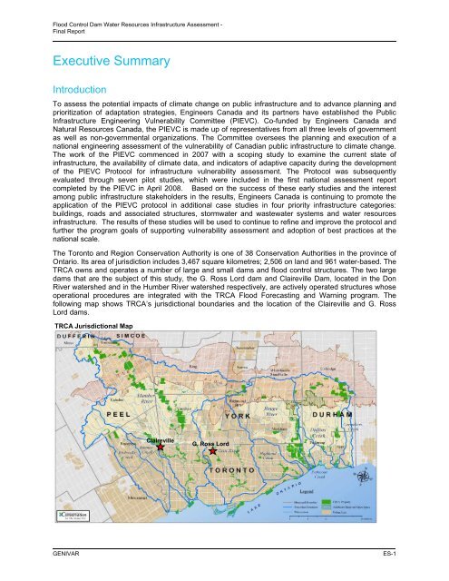
Flood Control Dam Water Resources Infrastructure Assessment -<strong>Final</strong> <strong>Report</strong>Executive SummaryIntroductionTo assess the potential impacts of climate change on public infrastructure and to advance planning andprioritization of adaptation strategies, Engineers Canada and its partners have established the PublicInfrastructure Engineering <strong>Vulnerability</strong> <strong>Committee</strong> (PIEVC). Co-funded by Engineers Canada andNatural Resources Canada, the PIEVC is made up of representatives from all three levels of governmentas well as non-governmental organizations. The <strong>Committee</strong> oversees the planning and execution of anational engineering assessment of the vulnerability of Canadian public infrastructure to climate change.The work of the PIEVC commenced in 2007 with a scoping study to examine the current state ofinfrastructure, the availability of climate data, and indicators of adaptive capacity during the developmentof the PIEVC Protocol for infrastructure vulnerability assessment. The Protocol was subsequentlyevaluated through seven pilot studies, which were included in the first national assessment reportcompleted by the PIEVC in April 2008. Based on the success of these early studies and the interestamong public infrastructure stakeholders in the results, Engineers Canada is continuing to promote theapplication of the PIEVC protocol in additional case studies in four priority infrastructure categories:buildings, roads and associated structures, stormwater and wastewater systems and water resourcesinfrastructure. The results of these studies will be used to continue to refine and improve the protocol andfurther the program goals of supporting vulnerability assessment and adoption of best practices at thenational scale.The Toronto and Region Conservation Authority is one of 38 Conservation Authorities in the province ofOntario. Its area of jurisdiction includes 3,467 square kilometres; 2,506 on land and 961 water-based. TheTRCA owns and operates a number of large and small dams and flood control structures. The two largedams that are the subject of this study, the G. Ross Lord dam and Claireville Dam, located in the DonRiver watershed and in the Humber River watershed respectively, are actively operated structures whoseoperational procedures are integrated with the TRCA Flood Forecasting and Warning program. Thefollowing map shows TRCA’s jurisdictional boundaries and the location of the Claireville and G. RossLord dams.TRCA Jurisdictional MapClairevilleG. Ross LordGENIVARES-1