27915_100286295karachicityclimatechangead
27915_100286295karachicityclimatechangead
27915_100286295karachicityclimatechangead

You also want an ePaper? Increase the reach of your titles
YUMPU automatically turns print PDFs into web optimized ePapers that Google loves.
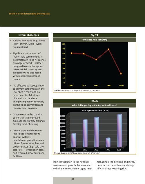
Section 2: Understanding the ImpactsCritical Challenges• A Flood Risk Zone (E.g. ‘FloodPlain’ of Lyari/Malir Rivers)not identified• Significant settlements of‘vulnerable communities‘ inpotential high flood risk zones• Drainage networks neitherdesigned to cater for appropriaterainfall intensity andprobability and also facedwith blockages/encroachments• No effective policy/regulationto prevent settlements in the‘river beds’, ‘hills’ and encroachmentsof drainagechannels and land usechanges impacting adverselyon the flood prevention andmanagement capacity• Green cover in the city thatcould facilitate improveddrainage (parks/play grounds,farming land) shrinking• Critical gaps and shortcomingsin the ‘emergency response’systems –health/emergency/trauma facilities,fire services, law andorder services (E.g. ‘safe shelters’)etc. – ‘evacuation plans’and required procedures andfacilitiesFig. 24Farmlands Also Vanishing807060504030201001960 1972 1980 1990 2000(Source: Department of Geography, University of Karachi)180000160000140000120000100000800006000040000200000Fig. 25what is happening in the Agricultural lands!total Agricultural land (Acres)1960 1972 1980 1990 2000(Source: Department of Geography, University of Karachi)their contribution to the nationaleconomy and growth. Issues relatedwith the way we are managing (mis-managing!) the city land and institutionsfurther complicate and magnifyan already existing risk.34