
Create successful ePaper yourself
Turn your PDF publications into a flip-book with our unique Google optimized e-Paper software.
10<br />
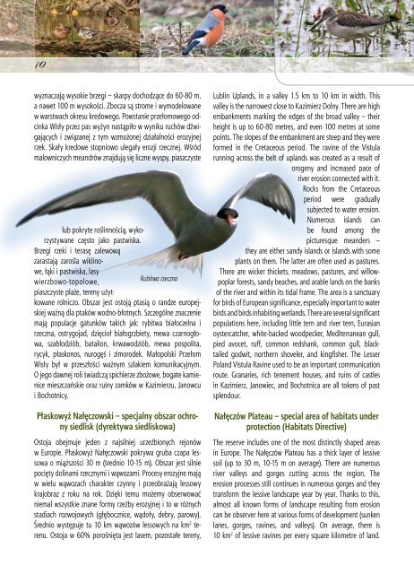
wyznaczają wysokie brzegi – skarpy dochodzące do 60-80 m,<br />
a nawet 100 m wysokości. Zbocza są strome i wymodelowane<br />
w warstwach okresu kredowego. Powstanie przełomowego odcinka<br />
Wisły przez pas wyżyn nastąpiło w wyniku ruchów dźwigających<br />
i związanej z tym wzmożonej działalności erozyjnej<br />
rzek. Skały kredowe stopniowo ulegały erozji rzecznej. Wśród<br />
malowniczych meandrów znajdują się liczne wyspy, piaszczyste<br />
Rubitwa rzeczna<br />
lub pokryte roślinnością, wykorzystywane<br />
często jako pastwiska.<br />
Brzegi rzeki i terasę zalewową<br />
zarastają zarośla wiklinowe,<br />
łąki i pastwiska, lasy<br />
wierzbowo-topolowe,<br />
piaszczyste plaże, tereny użytkowane<br />
rolniczo. Obszar jest ostoją ptasią o randze europejskiej<br />
ważną dla ptaków wodno-błotnych. Szczególne znaczenie<br />
mają populacje gatunków takich jak: rybitwa białoczelna i<br />
rzeczna, ostrygojad, dzięcioł białogrzbiety, mewa czarnogłowa,<br />
szablodziób, batalion, krwawodziób, mewa pospolita,<br />
rycyk, płaskonos, nurogęś i zimorodek. Małopolski Przełom<br />
Wisły był w przeszłości ważnym szlakiem komunikacyjnym.<br />
O jego dawnej roli świadczą spichlerze zbożowe, bogate kamienice<br />
mieszczańskie oraz ruiny zamków w Kazimierzu, Janowcu<br />
i Bochotnicy.<br />
Płaskowyż Nałęczowski – specjalny obszar ochrony<br />
siedlisk (dyrektywa siedliskowa)<br />
Ostoja obejmuje jeden z najsilniej urzeźbionych rejonów<br />
w Europie. Płaskowyż Nałęczowski pokrywa gruba czapa lessowa<br />
o miąższości 30 m (średnio 10-15 m). Obszar jest silnie<br />
pocięty dolinami rzecznymi i wąwozami. Procesy erozyjne mają<br />
w wielu wąwozach charakter czynny i przeobrażają lessowy<br />
krajobraz z <strong>roku</strong> na rok. Dzięki temu możemy obserwować<br />
niemal wszystkie znane formy rzeźby erozyjnej i to w różnych<br />
stadiach rozwojowych (głębocznice, wądoły, debry, parowy).<br />
Średnio występuje tu 10 km wąwozów lessowych na km 2 terenu.<br />
Ostoja w 60% porośnięta jest lasem, pozostałe tereny,<br />
Lublin Uplands, in a valley 1.5 km to 10 km in width. This<br />
valley is the narrowest close to Kazimierz Dolny. There are high<br />
embankments marking the edges of the broad valley – their<br />
height is up to 60-80 metres, and even 100 metres at some<br />
points. The slopes of the embankment are steep and they were<br />
formed in the Cretaceous period. The ravine of the Vistula<br />
running across the belt of uplands was created as a result of<br />
orogeny and increased pace of<br />
river erosion connected with it.<br />
Rocks from the Cretaceous<br />
period were gradually<br />
subjected to water erosion.<br />
Numerous islands can<br />
be found among the<br />
picturesque meanders –<br />
they are either sandy islands or islands with some<br />
plants on them. The latter are often used as pastures.<br />
There are wicker thickets, meadows, pastures, and willowpoplar<br />
forests, sandy beaches, and arable lands on the banks<br />
of the river and within its tidal frame. The area is a sanctuary<br />
for birds of European significance, especially important to water<br />
birds and birds inhabiting wetlands. There are several significant<br />
populations here, including little tern and river tern, Eurasian<br />
oystercatcher, white-backed woodpecker, Mediterranean gull,<br />
pied avocet, ruff, common redshank, common gull, blacktailed<br />
godwit, northern shoveler, and kingfisher. The Lesser<br />
Poland Vistula Ravine used to be an important communication<br />
route. Granaries, rich tenement houses, and ruins of castles<br />
in Kazimierz, Janowiec, and Bochotnica are all tokens of past<br />
splendour.<br />
Nałęczów Plateau – special area of habitats under<br />
protection (Habitats Directive)<br />
The reserve includes one of the most distinctly shaped areas<br />
in Europe. The Nałęczów Plateau has a thick layer of lessive<br />
soil (up to 30 m, 10-15 m on average). There are numerous<br />
river valleys and gorges cutting across the region. The<br />
erosion processes still continues in numerous gorges and they<br />
transform the lessive landscape year by year. Thanks to this,<br />
almost all known forms of landscape resulting from erosion<br />
can be observer here at various forms of development (sunken<br />
lanes, gorges, ravines, and valleys). On average, there is<br />
10 km 2 of lessive ravines per every square kilometre of land.