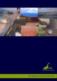
Mangrove Cove
Environmental Management Plan for Mangrove Cove - Delta ...
Environmental Management Plan for Mangrove Cove - Delta ...
- No tags were found...

Create successful ePaper yourself
Turn your PDF publications into a flip-book with our unique Google optimized e-Paper software.
Delta<br />
<strong>Mangrove</strong> <strong>Cove</strong> Management Plan<br />
5.2.1 Climate, geology and soils<br />
The climate on the Northern Adelaide Plains is described as Mediterranean, with cold, wet<br />
winters and hot dry summers. The nearest, and most similar, weather station is located in the<br />
extratidal areas at the Dry Creek Saltfields. The Dry Creek Saltfields’ weather station records<br />
an average of 420 mm of rain annually. This rainfall mainly occurs between May and<br />
September. Strong south-westerly winds regularly occur during autumn and spring, with hot<br />
northerly winds often occurring during summer. In winter a light northerly breeze blows in<br />
the early mornings. Lightning storms occasionally occur through out the year, but with higher<br />
intensity in mid to late spring.<br />
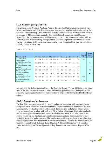
Table 1 - Weather details<br />
Annual<br />
Weather Aspect Jan Feb Mar Apr May Jun Jul Aug Sep Oct Nov Dec<br />
Annual<br />
Total<br />
Daily<br />
Average<br />
Av Monthly Rain<br />
(56 years)(mm)<br />
19.3 20.8 20.7 36.9 53.9 52.7 57.1 48.7 22.6 40.4 23.7 23.6 420.4<br />
Av Daily Maximum Temp<br />
(10 yrs) ( o C)<br />
26.0 27.8 26.1 21.6 18.5 15.6 14.5 15.5 17.9 20.9 23.6 25.6 21.1<br />
Av Daily Minimum Temp<br />
(10 yrs)( o C)<br />
15.9 15.6 15.0 11.8 9.6 8.4 7.1 7.6 8.9 11.1 13.2 15.0 11.6<br />
Av Daily Vapour Pressure<br />
(10 yrs) (mm Hg)<br />
12.0 11.3 10.7 9.7 9.1 8.4 7.9 8.1 8.6 8.9 10.1 11.2 9.7<br />
Av Daily Wind Speed<br />
(7 yrs) km/hr<br />
5.7 4.3 4.0 3.5 3.4 4.1 4.4 4.7 5.6 5.7 5.1 5.3 4.6<br />
Av Monthly Gross Evap.<br />
(56 yrs) (mm)<br />
302 217 217 133 82 56 56 76 109 164.9 274 273 1960<br />
Av Monthly Nett Evap.<br />
(56 yrs) (mm)<br />
283 197 196 97 28 3 -1 27 86 125 250 2500 1539<br />
According to the Soil Association Map of the Adelaide Region (Taylor, 1989) the underlying<br />
soils in the area are historic estuarine muds and sands (layered sediments, being sands, silts,<br />
clays and organic deposits of mixed marine and river origins) that form part of the Port River<br />
estuary.<br />
5.2.1.1 Evolution of the landscape<br />
The Port River was quite narrow in its upper reaches and was edged with swamplands and<br />
mangroves when Europeans first settled the area. Most land to the east and west of the river<br />
was originally intertidal swamp, mudflats, small dunes (berms) and chenier ridges, which<br />
have been raised and levelled with hydraulic fill or industrial dumping. Early diagram books<br />
and field survey books at the Lands Titles Office show that much of the area south of the<br />
current Jervois Bridge has been earmarked for reclamation at one stage or another in the<br />
period between 1856 and the present. The southern area of <strong>Mangrove</strong> <strong>Cove</strong> is one of the few<br />
areas along the inner Port that remains at natural surface level. This may be because it was the<br />
location of a small creek that once drained Section 914 (west of the railway). It was also<br />
useful as a drainage aid for any hydraulic filling that occurred on the northerly parts of the<br />
site.<br />
LMC-MCR-001-PC/RE Page 13