Middle Fork Irrigation District
Middle Fork Irrigation District
Middle Fork Irrigation District

You also want an ePaper? Increase the reach of your titles
YUMPU automatically turns print PDFs into web optimized ePapers that Google loves.
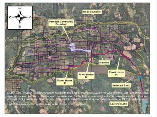
<strong>Middle</strong> <strong>Fork</strong> <strong>Irrigation</strong> <strong>District</strong> boundaries are the <strong>Middle</strong> <strong>Fork</strong> of the Hood River on the west and the East <strong>Fork</strong> of the Hood<br />
River on the east and north. On the south the watershed for the <strong>District</strong> extends onto the northern slopes of Mt. Hood and<br />
includes Eliot, Langille and Coe Glaciers. The small town of Parkdale, is located near the center of MFID irrigated lands.<br />
Locally the area is described as being in the Upper Hood River Valley.