


You also want an ePaper? Increase the reach of your titles
YUMPU automatically turns print PDFs into web optimized ePapers that Google loves.
© Faungg<br />
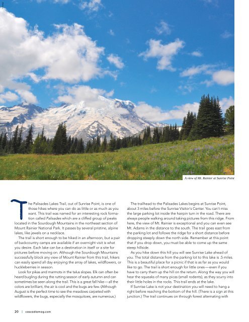
A view of Mt. Rainier at Sunrise Point<br />
meadow on fairly level ground to Clover Lake, 1.5 miles from the<br />
parking lot and the second and largest lake in the chain. Clover<br />
Lake, another great spot for a picnic lunch, is a good destination<br />
for a family outing with older children. Note: there are small trails<br />
along the banks — please don’t stray off of them, as the meadow<br />
is fragile and is easily damaged by hiking boots.<br />
The main trail travels past Clover Lake, up the next hill and<br />
down the other side — another steep grade. Again, coming back<br />
on this part of the hike will get your heart-rate up. You cross<br />
another large meadow, with the rocky ridge to the west getting<br />
more impressive as you hike on. The definition of Palisades<br />
becomes more apparent. At 2.6 miles from the parking lot is the<br />
junction to Hidden Lake. The trail heads west, up and into the<br />
ridge on a fairly steep path. As you gain in elevation, you get a<br />
terrific view of the meadows and hills below. It seems with each<br />
corner you turn, there is another beautiful sight to behold. If you<br />
look south you can see a flat section on the far ridge — this is<br />
the parking lot where you began this hike. It is surprising how far<br />
you have come. As you crest this hill, .5 miles from the junction,<br />
you come upon Hidden Lake. The crystal clear waters allow you<br />
to see the sandy bottom of this crescent-shaped lake. The trail<br />
goes to the right and then to the left, just above the shoreline. As<br />
you round the second corner, the amazing rocky cliffs come into<br />
view and you realize that you are in a huge bowl. Above you, the<br />
cliff-face looks like vertical columns. Many of those columns have<br />
broken away and fallen down the hillside.<br />
If your destination is still the Palisades Lakes, stay right at the<br />
Hidden Lake Junction. You will pass by Tom, Dick and Harry Lakes<br />
on the right side of the path. (Dick Camp is located on a short<br />
spur trail.) The trail continues on through rolling meadows and<br />
woods until you reach Upper Palisades Lake on the left (at 3.5<br />
miles from the trailhead). After a relaxing rest and delicious lunch<br />
(and perhaps a quick swim), you will be ready for the 3.5 - mile hike<br />
back to the parking lot.<br />
Flowers in bloom, late August<br />
© Angela Ivy<br />
© Angela Ivy<br />
The Palisades Lakes Trail, out of Sunrise Point, is one of<br />
those hikes where you can do as little or as much as you<br />
want. This trail was named for an interesting rock formation<br />
called Palisades which are a cliffed group of peaks<br />
located in the Sourdough Mountains in the northeast section of<br />
Mount Rainier National Park. It passes by several pristine, alpine<br />
lakes, like jewels on a necklace.<br />
The trail is short enough to be hiked in an afternoon, but a pair<br />
of backcountry camps are available if an overnight visit is what<br />
you desire. Each lake can be a destination in itself or a site for<br />
pictures before moving on. Although the Sourdough Mountains<br />
successfully block any view of Mount Rainier from this trail, hikers<br />
can easily spend all day enjoying the array of lakes, wildflowers, or<br />
huckleberries in season.<br />
Look for pikas and marmots in the talus slopes. Elk can often be<br />
heard bugling during the rutting season of early autumn and can<br />
sometimes be seen along the trail. This is a great fall hike — all the<br />
colors are brilliant, the air is cool and the bugs are few. (Although<br />
August is the perfect time to see the meadows carpeted with<br />
wildflowers, the bugs, especially the mosquitoes, are numerous.)<br />
The trailhead to the Palisades Lakes begins at Sunrise Point,<br />
about 3 miles before the Sunrise Visitor’s Center. You can’t miss<br />
the large parking lot inside the hairpin turn in the road. There are<br />
always people walking around taking pictures from this ridge. From<br />
here, the view of Mt. Rainier is exceptional and you can even see<br />
Mt. Adams in the distance to the south. The trail goes east from<br />
the parking lot and follows the ridge for a short distance before<br />
dropping steeply down the north side. Remember at this point<br />
that if you drop down, you must be able to come up the same<br />
steep hillside.<br />
As you hike down this hill you will see Sunrise Lake ahead of<br />
you. The total distance from the parking lot to this lake is .5 miles.<br />
This is a beautiful place for a picnic if that is as far as you would<br />
like to go. The trail is short enough for little ones — even if you<br />
have to carry them up the hill on the return. Along the way you will<br />
hear the squeaks of many picas (small rodents), as they scurry into<br />
their little holes in the rocks. This trail ends at the lake.<br />
If Sunrise Lake is not your destination you will need to hang a<br />
right before reaching the bottom of the hill. (There is a sign at this<br />
junction.) The trail continues on through forest alternating with<br />
© Beautiful Washington<br />
© Beautiful Washington<br />
One of the many lakes on the trail<br />
20 | cascadiamag.com