


Create successful ePaper yourself
Turn your PDF publications into a flip-book with our unique Google optimized e-Paper software.
© Mike & Maureen<br />
© Travel Oregon<br />
© Team Danger<br />
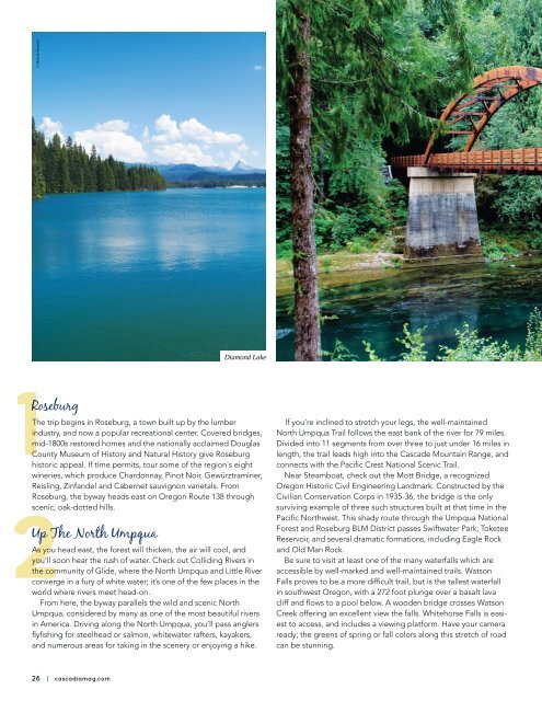
Diamond Lake<br />
Rogue Valley<br />
North Umpqua River<br />
1Roseburg<br />
The trip begins in Roseburg, a town built up by the lumber<br />
industry, and now a popular recreational center. Covered bridges,<br />
mid-1800s restored homes and the nationally acclaimed Douglas<br />
County Museum of History and Natural History give Roseburg<br />
historic appeal. If time permits, tour some of the region’s eight<br />
wineries, which produce Chardonnay, Pinot Noir, Gewürztraminer,<br />
Reisling, Zinfandel and Cabernet sauvignon varietals. From<br />
Roseburg, the byway heads east on Oregon Route 138 through<br />
scenic, oak-dotted hills.<br />
2Up The North Umpqua<br />
As you head east, the forest will thicken, the air will cool, and<br />
you’ll soon hear the rush of water. Check out Colliding Rivers in<br />
the community of Glide, where the North Umpqua and Little River<br />
converge in a fury of white water; it’s one of the few places in the<br />
world where rivers meet head-on.<br />
From here, the byway parallels the wild and scenic North<br />
Umpqua, considered by many as one of the most beautiful rivers<br />
in America. Driving along the North Umpqua, you’ll pass anglers<br />
flyfishing for steelhead or salmon, whitewater rafters, kayakers,<br />
and numerous areas for taking in the scenery or enjoying a hike.<br />
If you’re inclined to stretch your legs, the well-maintained<br />
North Umpqua Trail follows the east bank of the river for 79 miles.<br />
Divided into 11 segments from over three to just under 16 miles in<br />
length, the trail leads high into the Cascade Mountain Range, and<br />
connects with the Pacific Crest National Scenic Trail.<br />
Near Steamboat, check out the Mott Bridge, a recognized<br />
Oregon Historic Civil Engineering Landmark. Constructed by the<br />
Civilian Conservation Corps in 1935-36, the bridge is the only<br />
surviving example of three such structures built at that time in the<br />
Pacific Northwest. This shady route through the Umpqua National<br />
Forest and Roseburg BLM District passes Swiftwater Park, Toketee<br />
Reservoir, and several dramatic formations, including Eagle Rock<br />
and Old Man Rock.<br />
Be sure to visit at least one of the many waterfalls which are<br />
accessible by well-marked and well-maintained trails. Watson<br />
Falls proves to be a more difficult trail, but is the tallest waterfall<br />
in southwest Oregon, with a 272 foot plunge over a basalt lava<br />
cliff and flows to a pool below. A wooden bridge crosses Watson<br />
Creek offering an excellent view the falls. Whitehorse Falls is easiest<br />
to access, and includes a viewing platform. Have your camera<br />
ready; the greens of spring or fall colors along this stretch of road<br />
can be stunning.<br />
3Sparkling Diamond Lake<br />
Once it leaves the North Umpqua, Route 138 turns south to circle<br />
Diamond Lake,a scenic gem nestled between Mt. Bailey and the<br />
lightning-rod spire of Mt. Thielsen. Here you’ll find year-round<br />
resort facilities, including lodging, a marina and horse stables.<br />
In summer and fall, you can fish for stocked rainbow trout or bike<br />
around the lake on a paved path. In the winter the path is transformed<br />
into a groomed cross-country ski trail, and the lake into<br />
a giant ice rink. Mt. Bailey offers outstanding snowcat skiing.<br />
At the southern end of Diamond Lake, Oregon Route 138 rises<br />
toward the east and north entrance of Crater Lake National Park.<br />
The Rogue-Umpqua scenic byway heads west to join Oregon<br />
Route 230. Here you can enjoy unimpeded views of the peaks and<br />
ridges above Crater Lake from the Crater Rim viewpoint. Running<br />
down the Upper Rogue coursing through the Rogue River-Siskiyou<br />
National Forests, Oregon Route 230 merges with Oregon Route<br />
62 near historic Union Creek.<br />
Union Creek is the western terminus of the Fort Klamath Military<br />
Wagon Road, once an important trail for settlers crossing the<br />
Cascades. Union Creek is also the site of a historic resort built<br />
by the Civilian Conservation Corps. The road soon parallels the<br />
wild and scenic upper Rogue River. The upper Rogue, like the<br />
North Umpqua, supports endangered populations of Chinook<br />
and coho salmon, as well as steelhead and cutthroat trout. The<br />
Rogue Gorge and Natural Bridge interpretive sites offer interesting<br />
perspectives of the river as it thunders through deep, narrow<br />
chasms. Under a canopy of conifers between here and Prospect,<br />
you’ll find several riverside campgrounds where you can enjoy the<br />
sounds of the river or hook a few trout.<br />
Wildflowers are abundant along the Upper Rogue, providing<br />
a brilliant contrast to the green of the forests. Lost Creek Lake at<br />
Stewart State Park is popular for boating and waterskiing, among<br />
other outdoor activities. Farther south, Shady Cove is a popular<br />
point of departure for river rafters and anglers setting out to float<br />
the upper Rogue.<br />
4Gold Hill and the Rogue Valley<br />
Oregon Route 234 heads west, rejoining the upper Rogue River<br />
in the town of Gold Hill, the Byway’s southern portal. En route,<br />
Medford BLM and Table Rocks — flat-topped remnants of lava<br />
flows that filled the canyons of the Upper Rogue over seven million<br />
years ago — rise dramatically from the valley with Upper Table<br />
Rock soaring 800 feet. From here, the bustling Rogue Valley cities<br />
of Medford, Ashland, and Grants Pass are less than an hour away.<br />
26 | cascadiamag.com<br />
August/September 2017 | 27