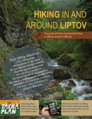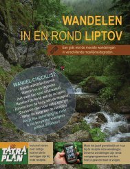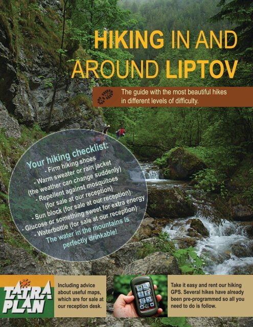
Hiking in and aroud Liptov
The guide with the most beautiful hikes in different levels of difficulty.
The guide with the most beautiful hikes in different levels of difficulty.

You also want an ePaper? Increase the reach of your titles
YUMPU automatically turns print PDFs into web optimized ePapers that Google loves.
HIKING IN AND<br />
AROUND LIPTOV<br />
The guide with the most beautiful hikes<br />
<strong>in</strong> different levels of difficulty.<br />
Your hik<strong>in</strong>g checklist:<br />
- Firm hik<strong>in</strong>g shoes<br />
- Warm sweater or ra<strong>in</strong> jacket<br />
(the weather can change suddenly)<br />
- Repellent aga<strong>in</strong>st mosquitoes<br />
(for sale at our reception)<br />
- Sun block (for sale at our reception)<br />
- Glucose or someth<strong>in</strong>g sweet for extra energy<br />
- Waterbottle (for sale at our reception)<br />
The water <strong>in</strong> the mounta<strong>in</strong>s is<br />
perfectly dr<strong>in</strong>kable!<br />
Includ<strong>in</strong>g advice<br />
about useful maps,<br />
which are for sale at<br />
Take it easy <strong>and</strong> rent our hik<strong>in</strong>g<br />
GPS. Several hikes have already<br />
been pre-programmed so all you<br />
Corrected on 18. january 2016. Pleace <strong>in</strong>form the reception Corrected about on any june mistakes. 23rd 2016. Please <strong>in</strong>form us about any <strong>in</strong>accuracies.<br />
our reception desk.<br />
need to do is follow.<br />
In case of emergency <strong>in</strong> the mounta<strong>in</strong>s: call 18300, or the In case hotel: of 044 emergency / 547 5656 <strong>in</strong> the mounta<strong>in</strong>s: call 18300, or the hotel: 044 / 547 5656
THE HIGHEST TOPS OF THE LOW TATRA<br />
You reach the highest tops of the Low Tatra Mounta<strong>in</strong>s Biela by Púť cable cars. From here you can take<br />
wonderful hikes or just enjoy the view.<br />
Naamloze laag<br />
Tatra plan 5003<br />
“Nízke Tatry”<br />
DIRECTIONS TO THE START OF THE HIKE<br />
w 9.7 km<br />
Directions from Malatíny-Stredné<br />
From Sojka resort, take a left turn onto route 18.<br />
Malatíny to Jasná Nízke Tatry,<br />
r 105 m. s 980 m. 2:55 h.<br />
Demänovská Dol<strong>in</strong>a<br />
After about 5 km you follow a slight turn to the left onto the ramp to<br />
Malatíny-Stredné Malatíny<br />
Poprad. Enter onto the turnpike E50. After about 13 km you take the first<br />
Jasná Nízke Tatry,<br />
exit <strong>Liptov</strong>ský Mikuláš. Then, take the first exit on the roundabout Demänovská Dol<strong>in</strong>a onto<br />
road 584 <strong>in</strong> the direction of Demänová/Jasná. You drive w<strong>and</strong>el<strong>in</strong>g through the<br />
Demänová valley (where you can f<strong>in</strong>d beautiful caves) <strong>and</strong> after about 14<br />
km you arrive at ski station Biela Púť. Before you pass the lake, turn left<br />
onto park<strong>in</strong>g lot P2 <strong>and</strong> park your car <strong>in</strong> front of the box office.<br />
CABLE CARS<br />
Buy a ticket at the box office (return ticket, or just one way up). Keep<br />
<strong>in</strong> m<strong>in</strong>d there’s a 2 euro deposit on the cards so return them on your<br />
way back. There are three legs on the way up to Chopok. You start <strong>in</strong> a<br />
four-seater. After this, you walk to the tw<strong>in</strong>l<strong>in</strong>er (ski car on rails), which is<br />
operated just like an elevator. This second leg ends up at Priehyba. From<br />
here a Funitel cable car departs to Chopok every 30 m<strong>in</strong>. You can have a<br />
dr<strong>in</strong>k with a beautiful view at the bar while you wait. Up on Chopok you<br />
have several options.<br />
Cable cars to Chopok<br />
The cable cars go every 30 m<strong>in</strong>. Check the time schedule,<br />
especially the depart<strong>in</strong>g time of the last cable car. Ask for more<br />
<strong>in</strong>formation <strong>and</strong> the up-to-date time schedule at our reception desk.<br />
Ticket: adult/reduced/child retour €18/15/13; up €15/12/10; down<br />
€13/11/9<br />
HIKE UP TO THE TOP OF CHOPOK<br />
You can walk up to the top of Chopok <strong>in</strong> 10 m<strong>in</strong>utes. It looks like a<br />
molehill <strong>and</strong> with its 2,024 m. it is the second highest top of the Low<br />
Tatra. Slightly lower, on 2,000 m, st<strong>and</strong>s the mounta<strong>in</strong> hut Kamenná<br />
Chata where you can have a meal <strong>and</strong> a dr<strong>in</strong>k. Follow<strong>in</strong>g the blue<br />
hik<strong>in</strong>g trail you can descend underneath the cable cars. At Luková,<br />
where you got on the Funitel, you take a left onto the red trail. Turn<br />
right when you arrive at the cross<strong>in</strong>g with the blue trail <strong>and</strong> follow<br />
the blue trail to Vrbické Pleso. From hare you take the yellow trail,<br />
back to Biela Púť.<br />
Vrbické Pleso
HIKE UP TO THE TOP OF ĎUMBIER<br />
From Chopok (2,024 m.) it´s a 4.5 km walk to the highest po<strong>in</strong>t of<br />
the Low Tatra: Ďumbier (2,043 m.). Subsequently, you can return<br />
the same way you came there, or follow the green trail down.<br />
Then you take the red trail to Luková <strong>and</strong> cont<strong>in</strong>ue as described<br />
above.<br />
HIKE VIA DEREŠE<br />
If it’s your first visit to Chopok, we recommend you try this hike.<br />
Start<strong>in</strong>g at the mounta<strong>in</strong> hut you take a beautiful 3.5 hour walk<br />
down. Follow the red trail <strong>in</strong> the direction of Dereše.<br />
w 1.4 km r 35 m. s 85 m. 0:25 h.<br />
After one hour you arrive at Sedlo Poľany. From here you follow the<br />
yellow trail down. The first part is a zigzag path with loose stones.<br />
Gradually you come <strong>in</strong>to the thicket that turns <strong>in</strong>to forest. After an<br />
hour you arrive at Tri Vody, where several mounta<strong>in</strong> streams come<br />
together.<br />
w 2.2 km r 0 m. s 465 m. 0:55 h.<br />
Top of Ďumbier<br />
Tri Vody<br />
Follow the yellow trail until you arrive at Mikulášska Chata.<br />
w 2.5 km r 0 m. s 240 m. 0:40 h.<br />
Frome there you follow the path around the photogenic glacier lake<br />
Vrbické Pleso. At the bridge you exit the forest <strong>and</strong> arrive at Hotel<br />
Gr<strong>and</strong>. From here you follow the asphalt road to Biela Púť. You<br />
pass an artificial lake that serves as a collect<strong>in</strong>g bas<strong>in</strong>.<br />
w 0.9 km r 20 m. s 35 m. 0:15 h.<br />
Corrected on 18. january 2016. Pleace <strong>in</strong>form the reception Corrected about on any june mistakes. 23rd 2016. Please <strong>in</strong>form us about any <strong>in</strong>accuracies.<br />
In case of emergency <strong>in</strong> the mounta<strong>in</strong>s: call 18300, or the In case hotel: of 044 emergency / 547 5656 <strong>in</strong> the mounta<strong>in</strong>s: call 18300, or the hotel: 044 / 547 5656
CANYON HIKE<br />
This diverse trip is everyone’s favourite <strong>and</strong><br />
suitable for the whole family. You walk through<br />
three completely different l<strong>and</strong>scapes.<br />
Tatra plan 5008<br />
“Chočské Vrchy”<br />
For this walk you don’t need to br<strong>in</strong>g a lunch pack. Penzión<br />
Borovec <strong>in</strong> Veľké Borové serves small dishes <strong>and</strong> dr<strong>in</strong>ks.<br />
w 16.2 km r 670 m. s 670 m. 4:45 h.<br />
DIRECTIONS TO THE START OF THE HIKE Velké Borové<br />
From Sojka resort take a left onto route 18.<br />
Follow the signs to Bešeňová (B) <strong>and</strong> keep<br />
go<strong>in</strong>g straight so you exit Bešeňová. After<br />
about 8 km you turn left to the village of<br />
Prosiek (D). Park your car on the park<strong>in</strong>g<br />
lot at the end of the village. Dur<strong>in</strong>g the high<br />
season the municipality ask a park<strong>in</strong>g fee.<br />
THE HIKE<br />
Prosiecka dol<strong>in</strong>a (640) - Velké Borové (820)<br />
Follow the blue trail. The first part of the<br />
hike passes through a l<strong>and</strong>scape of cliffs<br />
<strong>and</strong> a small river, via a few cha<strong>in</strong>s <strong>and</strong><br />
ladders. In case there have been showers,<br />
you’ll have to jump over en couple of rivers.<br />
After about 1.5 hour of walk<strong>in</strong>g you arrive at a highl<strong>and</strong> with the second type of<br />
l<strong>and</strong>scape. Keep follow<strong>in</strong>g the blue trail until you arrive at the village Veľké Borové.<br />
At the end of this village, along the blue trail, you’ll f<strong>in</strong>d Penzión Borovec where you<br />
can eat a soup or dr<strong>in</strong>k a beer.<br />
w 6.7 km r 325 m. s 145 m. 1:55 h.<br />
Velké Borové (820) - Kvačianska dol<strong>in</strong>a (650)<br />
After a short break you cont<strong>in</strong>ue on the blue trail, pass<strong>in</strong>g the third type of<br />
l<strong>and</strong>scape. The path goes down here until you arrive at the watermills, after about<br />
45 m<strong>in</strong>. This part of the hike goes along a quiet path <strong>in</strong> thick woodl<strong>and</strong>. After you<br />
have visited the watermills, keep follow<strong>in</strong>g the blue path (on the right side, steeply<br />
up, when you come back from the watermills). Then turn right onto the red trail to<br />
the village of Kvačany. Local brewery Brontvai (about 750 m <strong>in</strong>to the village passed<br />
the park<strong>in</strong>g <strong>in</strong> Kvačany, on the right side, house number 88) serves their own beer<br />
<strong>and</strong> small dishes.<br />
w 4.7 km r 135 m. s 305 m. 1:25 h.
Kvačianska dol<strong>in</strong>a, ústie (650) – Prosiecka dol<strong>in</strong>a (640)<br />
From Kvačany you turn right <strong>and</strong> follow the yellow trail,<br />
back to the park<strong>in</strong>g lot <strong>in</strong> Prosiek. M<strong>in</strong>d that the yellow trail<br />
starts just passed the park<strong>in</strong>g on the right side, across<br />
from the state farm. The mark<strong>in</strong>gs are not very clear. This<br />
last part of the hike takes about one hour, via the edge of<br />
the forest over pastures with beautiful views of reservoir<br />
<strong>Liptov</strong>ská Mara here <strong>and</strong> there.<br />
w 4.8 km r 210 m. s 220 m. 1:25 h.<br />
Kvačianska dol<strong>in</strong>a<br />
Oblazy<br />
Prosiecka dol<strong>in</strong>a<br />
Brewery Brontvai<br />
Corrected on 18. january 2016. Pleace <strong>in</strong>form the reception Corrected about on any june mistakes. 23rd 2016. Please <strong>in</strong>form us about any <strong>in</strong>accuracies.<br />
In case of emergency <strong>in</strong> the mounta<strong>in</strong>s: call 18300, or the In case hotel: of 044 emergency / 547 5656 <strong>in</strong> the mounta<strong>in</strong>s: call 18300, or the hotel: 044 / 547 5656
GREAT<br />
C H O Č<br />
This is, without a doubt, the mounta<strong>in</strong>top with the most panoramic<br />
view. Locals have made it a tradition to hike to the top on 31st of<br />
December, strengthened by tea <strong>and</strong> rum.<br />
Tatra plan 5008<br />
“Chočské Vrchy”<br />
It is good to take someth<strong>in</strong>g do eat <strong>and</strong> dr<strong>in</strong>k<br />
with you. Order a lunchbox at least one day<br />
beforeh<strong>and</strong> at our reception desk.<br />
DIRECTIONS TO THE START OF THE HIKE<br />
From Sojka resort, turn left onto route 18 <strong>in</strong><br />
the direction of Ružomberok. In Ružomberok,<br />
cont<strong>in</strong>ue straight on until you reach the cross<strong>in</strong>g<br />
with road 59. Turn right onto road 59 <strong>in</strong> the<br />
direction of Dolný Kubín. After 5 km you turn<br />
right to the village of Valaská Dubová. Park your<br />
car at the church.<br />
THE HIKE<br />
Valaská Dubová (658) - Stredná Poľana (1248)<br />
Follow the blue trail until you arrive at the<br />
cross<strong>in</strong>g with the green trail, after about 1,5<br />
hour. On this pasture you will f<strong>in</strong>d the shed<br />
“Hotel Choč” where you can take a rest. A<br />
geocache is hidden <strong>in</strong> the exterior of this<br />
“hotel”. If you leave someth<strong>in</strong>g beh<strong>in</strong>d <strong>in</strong> this<br />
treasure chest, you can take a small souvenir<br />
with you.<br />
w 3.1 km r 590 m. s 0 m. 1:40 h.<br />
w 11.4 km r 1,047 m. s 1047 m. 5:10 h.<br />
Stredná Poľana<br />
Stredná Poľana (1248) - Veľký Choč (1611)<br />
Follow the green trail to the top of Veľký Choč.<br />
This takes about one hour. If the weather is<br />
good, you’ll have the most beautiful view of<br />
<strong>Liptov</strong>, maybe of whole Slovakia. You can look<br />
around <strong>in</strong> 360 degrees.<br />
w 1,7 km r 350 m. s 0 m. 1:00 h.
Veľký Choč (1611) - Drapáč (1154)<br />
Take the red trail to the west until you cross the green trail,<br />
after about 45 m<strong>in</strong>. turn right onto the green trail. Another<br />
option is to take the same way down as you came up. In this<br />
case, your hike will be 40 m<strong>in</strong>utes shorter.<br />
Great Choč<br />
w 1.7 km r 0 m. s 457 m. 0:55 h.<br />
Drapáč (1154) - Stredná Poľana (1248)<br />
After 1.5 hour you arrive at the same pasture as on the way<br />
up, with “Hotel Choč”.<br />
w 1.1 km r 105 m. s 0 m. 0:25 h.<br />
Stredná Poľana (1248) - Valaská Dubová (658)<br />
From here you follow the blue trail back to Valaská Dubová.<br />
w 3.1 km r 0 m. s 590 m. 1:10 h.<br />
As a reward you can have a dr<strong>in</strong>k <strong>in</strong> Jánošíková Krčma.<br />
Jánošík (the Slovak Rob<strong>in</strong> Hood) was caught here after<br />
be<strong>in</strong>g betrayed.<br />
View from Great Choč <strong>in</strong> the w<strong>in</strong>ter<br />
In this tavern they caught Juraj Jánošík, <strong>in</strong> the year<br />
1713. He was betrayed by an old witch <strong>and</strong> her<br />
daughter Žofa for 200 ducats.<br />
Corrected on 18. january 2016. Pleace <strong>in</strong>form the reception Corrected about on any june mistakes. 23rd 2016. Please <strong>in</strong>form us about any <strong>in</strong>accuracies.<br />
In case of emergency <strong>in</strong> the mounta<strong>in</strong>s: call 18300, or the In case hotel: of 044 emergency / 547 5656 <strong>in</strong> the mounta<strong>in</strong>s: call 18300, or the hotel: 044 / 547 5656
W E S T E R N<br />
T A T R A<br />
západné tatry<br />
Untitled layer<br />
It is good to take someth<strong>in</strong>g do eat <strong>and</strong> dr<strong>in</strong>k with you. Order a<br />
lunchbox at least one day beforeh<strong>and</strong> Directions from Malatíny-Stredné<br />
at our reception desk.<br />
Malatíny to Unnamed Road, 032<br />
21 Bobrovec, Slovakia<br />
DIRECTIONS TO THE START OF THE HIKE<br />
Malatíny-Stredné Malatíny<br />
From Sojka resort you take a right onto route 18. After<br />
about 15 m<strong>in</strong>utes you arrive <strong>in</strong> Unnamed <strong>Liptov</strong>ský Road, 032 Mikuláš 21 where<br />
Bobrovec, Slovakia<br />
you turn right at the traffic light just passed the river,<br />
<strong>in</strong> the direction to Aquapark<br />
w<strong>and</strong>eltocht<br />
Tatral<strong>and</strong>ia. After about<br />
2 km you turn right <strong>in</strong> the direction of Bobrovec. Pass<br />
through the village until you arrive at the park<strong>in</strong>g lot.<br />
Here you f<strong>in</strong>d a small cable car <strong>and</strong> a chapel.<br />
THE HIKE<br />
Bobrovská Vápenica (750) - Pod Babkami (1245)<br />
Take the blue trail north. At the cross<strong>in</strong>g of trails you<br />
turn onto the green trail. The blue <strong>and</strong> the green tail<br />
<strong>in</strong>itially go together.<br />
The Western Tatra is the mounta<strong>in</strong> rage west of<br />
the High Tatra, also called the <strong>Liptov</strong> Tatra. Our<br />
dest<strong>in</strong>ation is the top that´s the furthest west of the<br />
Tatra Mounta<strong>in</strong>s: Sivý Vrch (Grey Mounta<strong>in</strong>)<br />
Tatra plan 2501<br />
“Západné Tatry”<br />
w 20.6 km r 1350 m. s 1350 m. 7:25 h.<br />
w 3.1 km r 515 m. s 20 m. 1:35 h.<br />
Pod Babkami (1245) - Sivý Vrch (1805)<br />
Via the green trail you hike on the tops of Babky<br />
(1566), Malá Kopa (1637), Veľká Kopa (1648)<br />
en Ostrab (1764) until you reach the top of Sivý<br />
Vrch. This rocky mounta<strong>in</strong>top is considered to be<br />
one of the most beautiful tops of Slovakia. Here<br />
you can choose to take the same way back, via<br />
the green <strong>and</strong> the blue trails. With<strong>in</strong> one hour<br />
you will arrive at the park<strong>in</strong>g lot. Another option<br />
is to follow the directions below.<br />
The top of Choč, seen from Babky<br />
w 5.6 km r 715 m. s 155 m. 2:25 h.
MAPOVÝ PORTÁL HIKING.SK<br />
Sedlo Pálenica<br />
+<br />
−<br />
Sivý Vrch (1805) - Sedlo Pálenica (1570)<br />
Follow the red trail to Sedlo Pálenica where you switch to<br />
the yellow trail southwards.<br />
w 2.1 km r 70 m. s 305 m. 0:50 h.<br />
Sedlo Pálenica (1570) - Bobrovecká Vápenica (750)<br />
Via the yellow trail you pass several lakes. Keep follow<strong>in</strong>g<br />
the river downhill. Cont<strong>in</strong>ue on the yellow trail until you<br />
reach the Mounta<strong>in</strong> hotel Mních. Here you take the first<br />
asphalt lane right to end up ant the park<strong>in</strong>g lot where you<br />
have parked your car.<br />
w 9.8 km r 50 m. s 870 m. 2:35 h.<br />
Topografický podklad © SHOCart<br />
Značky a rázcestia © HIKING.SK<br />
K M<br />
0 1 2<br />
The top of Sivý Vrch<br />
2000<br />
1500<br />
1000<br />
500<br />
0<br />
0 5 10 15 20<br />
Trasa podľa služby HIKEPLANNER<br />
Výsledky vyhľadávania<br />
stúpanie 1350 m klesanie 1350 m<br />
vzdialenosť 20.6 km čas 7:25<br />
Tlač detailný rozpis Výškový profil<br />
Upozornenie: Tento výtlačok z mapového portálu TURISTICKAMAPA.SK slúži výhradne na <strong>in</strong>formatívne účely. Všetky údaje vrátane <strong>in</strong>formácií zo služby HIKEPLANNER, či<br />
dôležitých bodov v mape, sú orientačné a môžu byť nepresné. Prevádzkovateľ vyslovene neodporúča také použitie tohto výtlačku, ktoré by nahrádzalo papierovú turistic<br />
© HIKING.SK – Určené výhradne pre osobnú potrebu.<br />
Corrected on 18. january 2016. Pleace <strong>in</strong>form the reception Corrected about on any june mistakes. 23rd 2016. Please <strong>in</strong>form us about any <strong>in</strong>accuracies.<br />
In case of emergency <strong>in</strong> the mounta<strong>in</strong>s: call 18300, or the In case hotel: of 044 emergency / 547 5656 <strong>in</strong> the mounta<strong>in</strong>s: call 18300, or the hotel: 044 / 547 5656
HIKING IN THE LOW TATRA<br />
You take a hike on the ridges of the Low Tatra with a vast view over the pla<strong>in</strong> of <strong>Liptov</strong>.<br />
Tatra plan 5003<br />
“NízkeTatry”<br />
You won´t f<strong>in</strong>d any mounta<strong>in</strong> huts along the way so it’s good to<br />
take someth<strong>in</strong>g do eat <strong>and</strong> dr<strong>in</strong>k with you. Order a lunchbox at<br />
least one day beforeh<strong>and</strong> at our reception desk.<br />
w 13.3 km r 864 m. s 864 m. 4:40 h.<br />
DIRECTIONS TO THE START OF THE HIKE<br />
From Sojka resort you take a left onto route 18. After about 1 km you drive <strong>in</strong>to the<br />
village Partizánska Ľupča. Follow the ma<strong>in</strong> road (between the two churches) until<br />
you exit the village. After about 12 km you turn left onto a small road marked as<br />
Magurka. Follow this path for 3 km until you reach Magurka <strong>and</strong> park your car <strong>in</strong><br />
the area of the red cottage Chata Magurka.<br />
THE HIKE<br />
Magurka (750) - Sedlo Ďurkvej (1709)<br />
From Magurka you follow the green trail to Sedlo Ďurkovej. You walk through<br />
the forrest <strong>and</strong> zigzagg<strong>in</strong>g you arrive at a small ridge which leads to the top of<br />
Ďurková.<br />
w 5.1 km r 725 m. s 51 m. 2:15 h.
Sedlo Ďurkvej (1709) - Chabanec (1955)<br />
This expansion is optional. Sedlo Ďurkovej is a<br />
cross<strong>in</strong>g of hik<strong>in</strong>g trails. You can choose to turn left<br />
<strong>and</strong> walk to the top of Chabanec. Here you have a<br />
small chance of spott<strong>in</strong>g chamois. Walk back the<br />
same way as you came to return to Sedlo Ďurkovej.<br />
On the way from Magurka to Sedlo Ďurkovej<br />
w 5.6 km r 246 m. s 246 m. 1:45 h.<br />
Sedlo Ďurkvej (1709) - Sedlo Latiborskej hole (1558)<br />
Follow the red trail to the top of Ďurková. You walk<br />
over the ridge of the Low Tatra until after aout 1,5<br />
hour you come at the cross<strong>in</strong>g with the blue trail.<br />
w 4.1 km r 102 m. s 253 m. 1:10 h.<br />
Sedlo Latiborskej hole (1558) - Magurka (750)<br />
Follow the path downhill back to Magurka. Be careful<br />
HIKING.SK for loose stones at the first part of this path. After this<br />
first part the path is properly walkable.<br />
View from the top of Chabanec<br />
w 4.1 km r 37 m. s 560 m. 1:15 h.<br />
Corrected on 18. january 2016. Pleace <strong>in</strong>form the reception Corrected about on any june mistakes. 23rd 2016. Please <strong>in</strong>form us about any <strong>in</strong>accuracies.<br />
In case of emergency <strong>in</strong> the mounta<strong>in</strong>s: call 18300, or the In case hotel: of 044 emergency / 547 5656 <strong>in</strong> the mounta<strong>in</strong>s: call 18300, or the hotel: 044 / 547 5656
Roháč<br />
Untitled layer<br />
R O H Á Č<br />
H I K E<br />
Directions from Stredné Malatíny,<br />
Malatíny to Penzión Š<strong>in</strong>dlovec,<br />
Zuberec-Zverovka<br />
This hike <strong>in</strong> the Western Tatra leads through beautiful<br />
l<strong>and</strong>scapes with mounta<strong>in</strong> lakes en a waterfall.<br />
Trails are closed <strong>in</strong> the w<strong>in</strong>ter season 1.11. – 16.06.!<br />
Stredné Malatíny, Malatíny<br />
It is good to take someth<strong>in</strong>g to eat <strong>and</strong> dr<strong>in</strong>k with you. Penzión<br />
Š<strong>in</strong>dlovec, where the hike starts <strong>and</strong> ends, serves food <strong>and</strong> dr<strong>in</strong>ks.<br />
Penzión Š<strong>in</strong>dlovec, Zuberec-<br />
It also functions as an <strong>in</strong>formation centre where you<br />
Zverovka<br />
can get the necessary <strong>in</strong>formation about Roháč <strong>and</strong><br />
the national w<strong>and</strong>eltocht<br />
natural park Tatra.<br />
DIRECTIONS TO THE START OF THE HIKE<br />
From Sojka resort, you take a right onto route 18.<br />
After about 15 m<strong>in</strong>utes you reach <strong>Liptov</strong>ský Mikuláš.<br />
Take the third exit on the roundabout <strong>in</strong> the direction<br />
to Aquapark Tatral<strong>and</strong>ia. Pass the aqua park <strong>and</strong> the<br />
village <strong>Liptov</strong>ský Trnovec. After a few km you reach<br />
the cross<strong>in</strong>g with road 584. Turn right to Zuberec.<br />
In Zuberec you turn right to the open-air museum<br />
Brestová. 4 km after Brestová you reach a fork <strong>in</strong> the<br />
road. Take a right (to Š<strong>in</strong>dlovec). Drive straight on as<br />
far as you´re allowed <strong>and</strong> park your car.<br />
THE HIKE<br />
Š<strong>in</strong>dlovec rázc. (1070) – Ťatliakova Chata (1374)<br />
Follow the red trail on the asphalt untill you reach<br />
Ťatliakova Chata. This is also the end of the red trail.<br />
w 3.5 km r 304 m. s 0 m. 1:10 h.<br />
Ťatliakova Chata (1374) – Roháčske plesá (1720)<br />
Here starts the beautiful hike, along the lakes of<br />
Roháč. The ideal walk goes south on the blue trail.<br />
After about 30 m<strong>in</strong> the trail splits <strong>and</strong> you follow the<br />
greet trail westwards. You pass the lakes of Roháč.<br />
w 3.4 km r 366 m. s 20 m. 1:05 h.<br />
Tatra plan 2501<br />
“West Tatra”<br />
Tatra plan 5008<br />
“Chočské Vrchy”<br />
w 11.6 km r 670 m. s 670 m. 3:55 h.
Roháčske plesá (1720) – Adamcuľa (1185)<br />
After a 45 m<strong>in</strong>. walk on the green trail you arrive at the<br />
cross<strong>in</strong>g with the blue trail. Follow the blue trail from<br />
here all the way up to Adamcuľa. You pass the beautiful<br />
waterfall of Roháč.<br />
One of the Roháč mounta<strong>in</strong> lakes<br />
w 3,1 km r 0 m. s 535 m. 1:05 h.<br />
Adamcuľa (1185) – Š<strong>in</strong>dlovec rázc.(1070)<br />
Turn left <strong>in</strong> Adamcuľa, onto the red trail (the asphalt<br />
path) to return to the park<strong>in</strong>g lot where you have parked<br />
your car.<br />
The opal mounta<strong>in</strong> lake of Roháč<br />
w 1.6 km r 0 m. s 115 m. 0:25 h.<br />
MAPOVÝ PORTÁL HIKING.SK<br />
The waterfall of Roháč<br />
+<br />
−<br />
Topografický podklad © SHOCart<br />
Značky a rázcestia © HIKING.SK<br />
K M<br />
0 0.5 1.0<br />
Corrected on 18. january 2016. Pleace <strong>in</strong>form the reception Corrected about on any june mistakes. 23rd 2016. Please <strong>in</strong>form us about any <strong>in</strong>accuracies.<br />
In case of emergency <strong>in</strong> the mounta<strong>in</strong>s: 2000 call 18300, or the In case hotel: of 044 emergency / 547 5656 <strong>in</strong> the mounta<strong>in</strong>s: call 18300, or the hotel: 044 / 547 5656<br />
1500<br />
1000<br />
500<br />
Trasa podľa služby HIKEPLANNER<br />
Výsledky vyhľadávania<br />
stúpanie 670 m klesanie 670 m<br />
vzdialenosť 11.6 km čas 3:55<br />
Tlač detailný rozpis Výškový profil
HIKE IN THE<br />
GREAT FATRA<br />
The offer of the bistro is fairly limited so we advise you to take a<br />
lunch package with you. You can order one a day beforeh<strong>and</strong> at<br />
our reception desk.<br />
DIRECTIONS TO THE START OF THE HIKE<br />
From Sojka resort you take a left onto route<br />
18 <strong>in</strong> the direction of Ružomberok. At the first<br />
traffic light (with the paper factory on your<br />
right-h<strong>and</strong> side) you go straight until you see<br />
the supermarket Hypernova. Turn left at the<br />
traffic lights. After the roundabout you turn right<br />
over the bridge. After you have crossed the<br />
bridge you ignore the turn left <strong>and</strong> after about<br />
200 m you take the street to the right (Majere).<br />
Park your car somewhere around the stairs<br />
that lead to the church.<br />
Walk up the stairs. Here you can f<strong>in</strong>d the<br />
mausoleum of priest Hl<strong>in</strong>ka. Up on the stairs<br />
you see the church <strong>and</strong> the city hall on the<br />
right side, <strong>and</strong> a school on the left. A wide<br />
boulevard with trees runs across from the city<br />
hall. On this boulevard you f<strong>in</strong>d signs of the<br />
green <strong>and</strong> the red trail.<br />
This is a varied hike with a part that goes through a<br />
forest, a visit to the UNESCO village Vlkolínec <strong>and</strong> ends<br />
<strong>in</strong> the allotment <strong>and</strong> residential part of Ružomberok.<br />
Tatra plan 5008<br />
“Chočské Vrchy”<br />
w 12.5 km r 530 m. s 530 m. 3:4 h.<br />
Up on th Calvary<br />
Ružomberok<br />
The stairs of<br />
Ružomberok
THE HIKE<br />
Ružomberok námestie (495) – Kalvária (600)<br />
Follow the red trail <strong>and</strong> exit the city through the quiet<br />
neighbourhood. You ascend on the asphalt road<br />
(Calvary).<br />
w 1.6 km r 110 m. s 5 m. 0:30 h.<br />
Kalvária (600) – Vlkolínske lúky (815)<br />
Once you have reached the top, the trail splits <strong>in</strong> a blue<br />
<strong>and</strong> a red path. If you follow blue, you walk on a calm<br />
forest path for one hour. Or you extend your hike <strong>and</strong><br />
follow the red trail via the top of Sidorovo (a climb of<br />
500 m.).<br />
M<strong>in</strong>izoo pod Sidorovom open 18.06.-18.09. 9-17<br />
w 3.4 km r 280 m. s 65 m. 1:10 h.<br />
Vlkolínske lúky (815) – Vlkolínec (720)<br />
A short walk from Vlkolínske lúky passes the M<strong>in</strong>izoo<br />
pod Sidorovom. Turn left up the hill. Keep follow<strong>in</strong>g the<br />
yellow trail (a rocky descend<strong>in</strong>g path) to the village of<br />
Vlkolínec. This village, also nicknamed the wolf village,<br />
is protected by UNESCO. It is a wonderful to w<strong>and</strong>er<br />
through. One of the first houses on the right side is a<br />
pub with a small store. Slowly stroll through the village.<br />
Every corner is like a postcard. Normally you pay<br />
entrance fee when enter<strong>in</strong>g the village, which grants<br />
you entrance to the local museum.<br />
w 1.5 km r 45 m. s 140 m. 0:30 h.<br />
Vlkolínec (720) – Ružomberok námestie (495)<br />
After your visit you exit the village via the church.<br />
From the church you follow the yellow trail for about<br />
600 m. At the fork <strong>in</strong> the road the trail turns right but<br />
you keep go<strong>in</strong>g straight. After 500 m. you notice the<br />
mark<strong>in</strong>g of the green hik<strong>in</strong>g trail. Follow<strong>in</strong>g these, you<br />
gradually arrive at the allotment that surrounds the city.<br />
Afterwards you pass through the residential part before<br />
arriv<strong>in</strong>g at the boulevard where your hike started.<br />
w 6 km r 95 m. s 320 m. 1:30 h.<br />
Corrected on 18. january 2016. Pleace <strong>in</strong>form the reception Corrected about on any june mistakes. 23rd 2016. Please <strong>in</strong>form us about any <strong>in</strong>accuracies.<br />
In case of emergency <strong>in</strong> the mounta<strong>in</strong>s: call 18300, or the In case hotel: of 044 emergency / 547 5656 <strong>in</strong> the mounta<strong>in</strong>s: call 18300, or the hotel: 044 / 547 5656
PARTIZÁNSKA<br />
Ľ U P Č A<br />
You take a walk, suited for the whole family, <strong>in</strong> the<br />
surround<strong>in</strong>g of our neighbour<strong>in</strong>g village Partizánska<br />
Ľupča. This walk strarts at Sojka resort.<br />
For this walk it is good to take a lunch pack with you. You can order one a day beforeh<strong>and</strong><br />
at our reception desk.<br />
THE WALK<br />
From Sojka resort to Partizánska Ľupča <strong>and</strong> back<br />
This walk is marked with red signs, usually on the<br />
right side of the road. From the hotel you take a<br />
right (not <strong>in</strong> the direction of route 18, but <strong>in</strong> the<br />
direction of the mounta<strong>in</strong>s). This road goes through<br />
Vyšné Malatíny. On the right side you can see the<br />
wooden chalets of Magura Village. A bit further on<br />
the right side you will notice the state farm, which is<br />
still be<strong>in</strong>g used by the shepherds. On the left side<br />
along the road notice the renovated home of our<br />
mayor. Keep follow<strong>in</strong>g this road straight on.<br />
After de last house, the road changes <strong>in</strong>to a road<br />
of cement blocks. Even further it becomes a gravel<br />
path (ignore the concrete road on the right here). At<br />
the end you walk a bit further on the grass usually<br />
there is a tractor trail) until you reach an asphalt<br />
path along the edge of the forest.<br />
Take a right onto this asphalt path. You are now<br />
walk<strong>in</strong>g along the first mounta<strong>in</strong> rage of the Low<br />
Tatra mounta<strong>in</strong>s, <strong>in</strong> the middle of nature. The path<br />
twists through meadows. Ignore some sidetrack on<br />
the left side. After more than one hour of walk<strong>in</strong>g,<br />
on the left side about 200 m <strong>in</strong>wards, you will see a<br />
small build<strong>in</strong>g of the water l<strong>in</strong>e with a fence around<br />
it. From here you can take an extended walk, markt<br />
with blue signs. Otherwise, just follow the direction<br />
as described on the next page.<br />
Tatra plan 5003<br />
“Nízke Tatry”<br />
w 9 km 3:00 h.<br />
View from Predná Magura with Partizánska Ľupča on the left <strong>and</strong> the<br />
lake <strong>Liptov</strong>ská Mara on the right<br />
EXTENDED HIKE (average difficulty)<br />
Rumanec – Predná Magura (1171)<br />
Walk <strong>in</strong> the direction of the build<strong>in</strong>g of the water l<strong>in</strong>e en keep<br />
follow<strong>in</strong>g this path until after 40 m<strong>in</strong>utes you arrive at a meadow with<br />
dr<strong>in</strong>k<strong>in</strong>g troughs for stock by the trees on the left side. This spot is<br />
called Rumanec <strong>and</strong> you can f<strong>in</strong>d the sight with this name <strong>and</strong> the<br />
altitude. From Rumanec you follow the yellow trail further up, for<br />
about one hour. Take note: At the memorial stone you don’t go left<br />
but keep go<strong>in</strong>g straight. The goal is the top Predná Magura (1171 m.)<br />
where you will have a great view of <strong>Liptov</strong> region. After tak<strong>in</strong>g a rest<br />
you follow the same way back. Take a left onto the asphalt path an<br />
follow the directions on the next page.<br />
w 8 km r 570 m. s 570 m. 3:00 h.
A bit further the asphalt path will end up at another asphalt path.<br />
Take a right here <strong>in</strong> the direction of Partizánska Ľupča. Once you<br />
arrive <strong>in</strong> the village you will pass a grocery store <strong>and</strong> a village<br />
pub next to it. In the centre you can also f<strong>in</strong>d pizzeria Jumi, a<br />
convenience store, a café, another gorcery store <strong>and</strong> a bar. In<br />
the middle of the village st<strong>and</strong>s the town hall (on the left with a<br />
storks nest on the roof), the old catholic church of St. Matthew<br />
(13th century), the more recent evangelical church (19th century)<br />
<strong>and</strong> the cultural centre.<br />
To return to Sojka resort you take a country road that leads to<br />
rout 18. Once you have passed the cultural centre you will have<br />
the rectory on your right side (the big build<strong>in</strong>g with old trees<br />
<strong>and</strong> a big cross <strong>in</strong> the front yard). On the right side of it passes<br />
a country road. Follow it <strong>and</strong> turn right onto the grass path along<br />
side route 18. At the end you will need to walk on rout 18 for a<br />
little while, until you arrive at the cross<strong>in</strong>g <strong>in</strong> front of Malatíny.<br />
Sojka resort is on your right.<br />
W<strong>in</strong>ery Pod Lipami <strong>in</strong> Partizánska Ľupča<br />
Partizánska<br />
Ľupča<br />
18<br />
Malatíny<br />
Sliače<br />
Rumanec<br />
Corrected on 18. january 2016. Pleace <strong>in</strong>form the reception Corrected about on any june mistakes. 23rd 2016. Please <strong>in</strong>form us about any <strong>in</strong>accuracies.<br />
In case of emergency <strong>in</strong> the mounta<strong>in</strong>s: call 18300, or the In case hotel: of 044 emergency / 547 5656 <strong>in</strong> the mounta<strong>in</strong>s: call 18300, or the hotel: 044 / 547 5656
LIPTOVSKÉ<br />
K Ľ A Č A N Y<br />
You can order a lunch pack for this walk, at least one day<br />
beforeh<strong>and</strong>, at our reception desk.<br />
THE WALK<br />
From Sojka resort to <strong>Liptov</strong>ské Kľačany <strong>and</strong> back<br />
This walk is marked with yellow signs, usually on the right side<br />
of the road. From Sojka resort you turn right (not to the cross<strong>in</strong>g<br />
with route 18, but <strong>in</strong> the direction of the mounta<strong>in</strong>s). This road<br />
goes through Vyšné Malatíny. On the right side you will notice the<br />
wooden chalets of Magura Village. A bit further on the right side<br />
you can see the renovated home where our mayor lives. Keep<br />
follow<strong>in</strong>g this road until after about 1.2 km you turn left, by the<br />
two wooden chalets. Turn left here <strong>and</strong> follow the tractor trail at<br />
the end of this path. It leads to a small chapel, about 2 km further.<br />
Take the slight turn left <strong>and</strong> keep follow<strong>in</strong>g the trail until you reach<br />
a narrow road. Turn right here <strong>and</strong> follow this road for another<br />
kilometre to <strong>Liptov</strong>ské Kľačany. Go straight at the cross<strong>in</strong>g, <strong>in</strong>to<br />
the village.<br />
<strong>Liptov</strong>ské Kľačany is a little bit bigger than Malatíny, quiet <strong>and</strong> nice<br />
to wonder through. After a short while you reach a small square<br />
with a supermarket <strong>and</strong> a pub. Keep right <strong>and</strong> turn right aga<strong>in</strong> at<br />
the next turn. Ignore the next right turn <strong>and</strong> exit the village <strong>in</strong> the<br />
direction of woods.<br />
After about 3.5 km you will notice a blue arrow on the road,<br />
po<strong>in</strong>t<strong>in</strong>g left. From here starts the extended hike to Predná Magura<br />
(as discribed <strong>in</strong> the walk of Partizánska Ľupča.) Take the three<br />
hour hike or turn right to walk back to Malatíny. After about 0.5 km,<br />
turn right aga<strong>in</strong> onto the tractor trail. F<strong>in</strong>ally, almost 2 km further,<br />
you turn left. This path leads you back to Malatíny <strong>and</strong> Sojka<br />
resort.<br />
You will visit our neighbour<strong>in</strong>g village <strong>Liptov</strong>ské<br />
Kľačany. The walk will take you through fields with two<br />
chapels <strong>and</strong> along the forest edge of the Low Tatra.<br />
w 10 km 4:45 h.<br />
Tatra plan 5003<br />
“Nízke Tatry”<br />
Corrected on 18. january 2016. Pleace <strong>in</strong>form the reception Corrected about on any june mistakes. 23rd 2016. Please <strong>in</strong>form us about any <strong>in</strong>accuracies.<br />
In case of emergency <strong>in</strong> the mounta<strong>in</strong>s: call 18300, or the In case hotel: of 044 emergency / 547 5656 <strong>in</strong> the mounta<strong>in</strong>s: call 18300, or the hotel: 044 / 547 5656