CC3001

You also want an ePaper? Increase the reach of your titles
YUMPU automatically turns print PDFs into web optimized ePapers that Google loves.
CASEstudy<br />
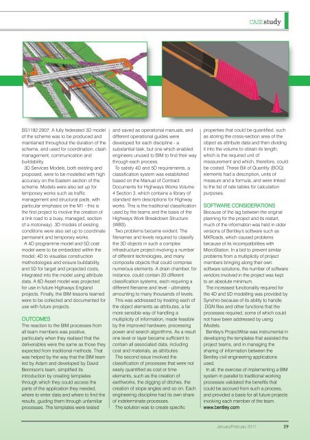
BS1192:2007. A fully federated 3D model<br />
of the scheme was to be produced and<br />
maintained throughout the duration of the<br />
scheme, and used for coordination, clash<br />
management, communication and<br />
buildability.<br />
3D Services Models, both existing and<br />
proposed, were to be modelled with high<br />
accuracy on the Eastern section of the<br />
scheme. Models were also set up for<br />
temporary works such as traffic<br />
management and structural pads, with<br />
particular emphasis on the M1 - this is<br />
the first project to involve the creation of<br />
a link road to a busy, managed, section<br />
of a motorway). 3D models of existing<br />
conditions were also set up to coordinate<br />
permanent and temporary works.<br />
A 4D programme model and 5D cost<br />
model were to be embedded within the<br />
model; 4D to visualise construction<br />
methodologies and ensure buildability,<br />
and 5D for target and projected costs,<br />
integrated into the model using attribute<br />
data. A 6D Asset model was projected<br />
for use in future Highways England<br />
projects. Finally, the BIM lessons learned<br />
were to be collected and documented for<br />
use with future projects.<br />
OUTCOMES<br />
The reaction to the BIM processes from<br />
all team members was positive,<br />
particularly when they realised that the<br />
deliverables were the same as those they<br />
expected from traditional methods. That<br />
was helped by the way that the BIM team<br />
led by Adam and developed by David<br />
Bennison's team, simplified its<br />
introduction by creating templates<br />
through which they could access the<br />
parts of the application they needed,<br />
where to enter data and where to find the<br />
results, guiding them through unfamiliar<br />
processes. The templates were tested<br />
and saved as operational manuals, and<br />
different operational guides were<br />
developed for each discipline - a<br />
substantial task, but one which enabled<br />
engineers unused to BIM to find their way<br />
through each process.<br />
To satisfy 4D and 5D requirements, a<br />
classification system was established<br />
based on the Manual of Contract<br />
Documents for Highways Works Volume<br />
4 Section 3, which contains a library of<br />
standard item descriptions for Highway<br />
works. This is the traditional classification<br />
used by the teams and the basis of the<br />
Highways Work Breakdown Structure<br />
(WBS).<br />
Two problems became evident. The<br />
filenames and levels required to classify<br />
the 3D objects in such a complex<br />
infrastructure project involving a number<br />
of different technologies, and many<br />
composite objects that could comprise<br />
numerous elements. A drain chamber, for<br />
instance, could contain 20 different<br />
classification systems, each requiring a<br />
different filename and level - ultimately<br />
amounting to many thousands of levels.<br />
This was addressed by treating each of<br />
the object elements as attributes, a far<br />
more sensible way of handling a<br />
multiplicity of information, made feasible<br />
by the improved hardware, processing<br />
power and search algorithms. As a result<br />
one level or layer became sufficient to<br />
contain all associated data, including<br />
cost and materials, as attributes.<br />
The second issue involved the<br />
classification of processes that were not<br />
easily quantified as cost or time<br />
elements, such as the creation of<br />
earthworks, the digging of ditches, the<br />
creation of slope angles and so on. Each<br />
engineering discipline had its own share<br />
of indeterminate processes.<br />
The solution was to create specific<br />
properties that could be quantified, such<br />
as storing the cross-section area of the<br />
object as attribute data and then dividing<br />
it into the volume to obtain its length,<br />
which is the required unit of<br />
measurement and which, therefore, could<br />
be costed. These Bill of Quantity (BOQ)<br />
elements had a description, units of<br />
measure and a formula, and were linked<br />
to the list of rate tables for calculation<br />
purposes.<br />
SOFTWARE CONSIDERATIONS<br />
Because of the lag between the original<br />
planning for the project and its restart,<br />
much of the information was held in older<br />
versions of Bentley's software such as<br />
MXRoads, which caused problems<br />
because of its incompatibilities with<br />
MicroStation. In a bid to prevent similar<br />
problems from a multiplicity of project<br />
members bringing along their own<br />
software solutions, the number of software<br />
vendors involved in the project was kept<br />
to an absolute minimum.<br />
The increased functionality required for<br />
the 4D and 5D modelling was provided by<br />
Synchro because of its ability to handle<br />
.DGN files and other functions that the<br />
processes required, some of which could<br />
not have been addressed by using<br />
iModels.<br />
Bentley's ProjectWise was instrumental in<br />
developing the templates that assisted the<br />
project teams, and in managing the<br />
sharing of information between the<br />
Bentley civil engineering applications<br />
used.<br />
In all, the exercise of implementing a BIM<br />
system in parallel to traditional working<br />
processes validated the benefits that<br />
could be accrued from such a process,<br />
and provided a basis for all future projects<br />
involving each member of the team.<br />
www.bentley.com<br />
January/February 2017 29