

Thesis Book

Create successful ePaper yourself
Turn your PDF publications into a flip-book with our unique Google optimized e-Paper software.
FORT MASON<br />
| WATER CLEANING INTERFACE | 2015 2016 | | PROJECT_ 01 | RE INDUSTRIALIZING | LOCATION | SAN FRANCISCO CA | FINAL THESIS<br />
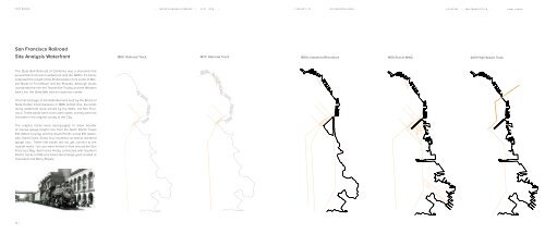
San Francisco Railroad<br />
Site Analysis Waterfront<br />
1860 Railroad Track 1870 Railroad Track<br />
1900s Industrial Revolution 1950 End of WW2 2013 High Speed Track<br />
The State Belt Railroad of California was a shoreline that<br />
served San Francisco’s waterfront until the 1980’s. It’s tracks<br />
extended the length of the Embarcadero from south of Market<br />
Street to Fort Mason and the Presidio. Although locals<br />
nicknamed the line the Toonerville Trolley and the Wooden<br />
Axle Line, the State Belt had an illustrious career.<br />
The first trackage of the State Belt was built by the Board of<br />
State Harbor Commissioners in 1889. At that time, the lands<br />
along waterfront were owned by the State, not San Francisco.<br />
These lands were once under water, so they were not<br />
included in the original survey of the City.<br />
The original tracks were dual-gauged, to allow transfer<br />
of narrow gauge freight cars from the North Pacific Coast<br />
R.R. (Marin County) and the South Pacific Coast R.R. (Alameda,<br />
Santa Clara, Santa Cruz counties), as well as standard<br />
gauge cars. These first tracks did not yet connect to the<br />
outside world - all cars were ferried in from around the San<br />
Francisco Bay. Belt tracks finally connected with Southern<br />
Pacific tracks in 1913 at a small interchange yard located at<br />
Townsend and Berry Streets.<br />
14 |