Viva Brighton Issue #52 June 2017

Create successful ePaper yourself
Turn your PDF publications into a flip-book with our unique Google optimized e-Paper software.
BRICKS AND MORTAR<br />
....................................<br />
<strong>Brighton</strong> and Hove at your fingertips<br />
Mapping the city through the ages<br />
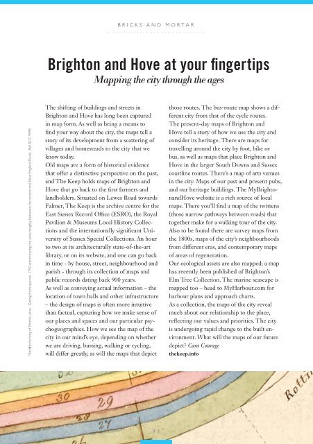
The fifth furlong of North Laine. Dating from approx. 1792 and showing the area roughly between the station and New England Road. Ref ACC 9495<br />
The shifting of buildings and streets in<br />
<strong>Brighton</strong> and Hove has long been captured<br />
in map form. As well as being a means to<br />
find your way about the city, the maps tell a<br />
story of its development from a scattering of<br />
villages and homesteads to the city that we<br />
know today.<br />
Old maps are a form of historical evidence<br />
that offer a distinctive perspective on the past,<br />
and The Keep holds maps of <strong>Brighton</strong> and<br />
Hove that go back to the first farmers and<br />
landholders. Situated on Lewes Road towards<br />
Falmer, The Keep is the archive centre for the<br />
East Sussex Record Office (ESRO), the Royal<br />
Pavilion & Museums Local History Collections<br />
and the internationally significant University<br />
of Sussex Special Collections. An hour<br />
to two at its architecturally state-of-the-art<br />
library, or on its website, and one can go back<br />
in time - by house, street, neighbourhood and<br />
parish - through its collection of maps and<br />
public records dating back 900 years.<br />
As well as conveying actual information – the<br />
location of town halls and other infrastructure<br />
– the design of maps is often more intuitive<br />
than factual, capturing how we make sense of<br />
our places and spaces and our particular psychogeographies.<br />
How we see the map of the<br />
city in our mind’s eye, depending on whether<br />
we are driving, bussing, walking or cycling,<br />
will differ greatly, as will the maps that depict<br />
those routes. The bus-route map shows a different<br />
city from that of the cycle routes.<br />
The present-day maps of <strong>Brighton</strong> and<br />
Hove tell a story of how we use the city and<br />
consider its heritage. There are maps for<br />
travelling around the city by foot, bike or<br />
bus, as well as maps that place <strong>Brighton</strong> and<br />
Hove in the larger South Downs and Sussex<br />
coastline routes. There’s a map of arts venues<br />
in the city. Maps of our past and present pubs,<br />
and our heritage buildings. The My<strong>Brighton</strong>andHove<br />
website is a rich source of local<br />
maps. There you’ll find a map of the twittens<br />
(those narrow pathways between roads) that<br />
together make for a walking tour of the city.<br />
Also to be found there are survey maps from<br />
the 1800s, maps of the city’s neighbourhoods<br />
from different eras, and contemporary maps<br />
of areas of regeneration.<br />
Our ecological assets are also mapped; a map<br />
has recently been published of <strong>Brighton</strong>’s<br />
Elm Tree Collection. The marine seascape is<br />
mapped too – head to MyHarbour.com for<br />
harbour plans and approach charts.<br />
As a collection, the maps of the city reveal<br />
much about our relationship to the place,<br />
reflecting our values and priorities. The city<br />
is undergoing rapid change to the built environment.<br />
What will the maps of our future<br />
depict? Cara Courage<br />
thekeep.info<br />
....93....