

Miombo Ecoregion Vision Report - Biodiversity Foundation for Africa
Miombo Ecoregion Vision Report - Biodiversity Foundation for Africa
Miombo Ecoregion Vision Report - Biodiversity Foundation for Africa

Create successful ePaper yourself
Turn your PDF publications into a flip-book with our unique Google optimized e-Paper software.
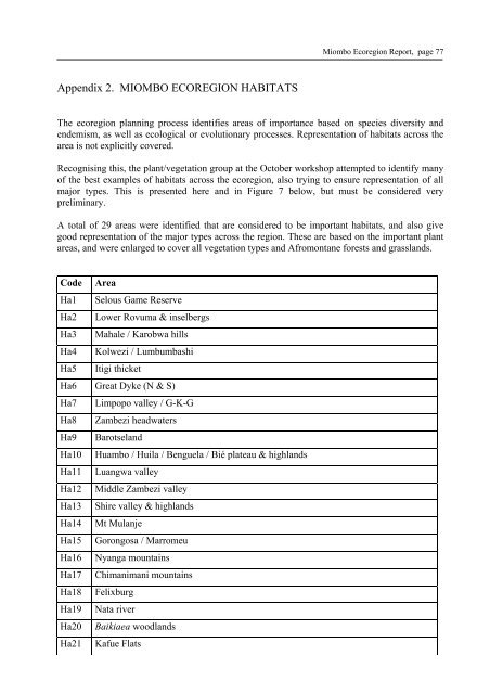
Appendix 2. MIOMBO ECOREGION HABITATS<br />
<strong>Miombo</strong> <strong>Ecoregion</strong> <strong>Report</strong>, page 77<br />
The ecoregion planning process identifies areas of importance based on species diversity and<br />
endemism, as well as ecological or evolutionary processes. Representation of habitats across the<br />
area is not explicitly covered.<br />
Recognising this, the plant/vegetation group at the October workshop attempted to identify many<br />
of the best examples of habitats across the ecoregion, also trying to ensure representation of all<br />
major types. This is presented here and in Figure 7 below, but must be considered very<br />
preliminary.<br />
A total of 29 areas were identified that are considered to be important habitats, and also give<br />
good representation of the major types across the region. These are based on the important plant<br />
areas, and were enlarged to cover all vegetation types and Afromontane <strong>for</strong>ests and grasslands.<br />
Code Area<br />
Ha1 Selous Game Reserve<br />
Ha2 Lower Rovuma & inselbergs<br />
Ha3 Mahale / Karobwa hills<br />
Ha4 Kolwezi / Lumbumbashi<br />
Ha5 Itigi thicket<br />
Ha6 Great Dyke (N & S)<br />
Ha7 Limpopo valley / G-K-G<br />
Ha8 Zambezi headwaters<br />
Ha9 Barotseland<br />
Ha10 Huambo / Huila / Benguela / Bié plateau & highlands<br />
Ha11 Luangwa valley<br />
Ha12 Middle Zambezi valley<br />
Ha13 Shire valley & highlands<br />
Ha14 Mt Mulanje<br />
Ha15 Gorongosa / Marromeu<br />
Ha16 Nyanga mountains<br />
Ha17 Chimanimani mountains<br />
Ha18 Felixburg<br />
Ha19 Nata river<br />
Ha20 Baikiaea woodlands<br />
Ha21 Kafue Flats