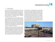
9.4/WOOLMARKET - City of Biloxi
9.4/WOOLMARKET - City of Biloxi
9.4/WOOLMARKET - City of Biloxi

You also want an ePaper? Increase the reach of your titles
YUMPU automatically turns print PDFs into web optimized ePapers that Google loves.
<strong>9.4</strong>/woolmarket<br />
overview<br />
Land Use<br />
Woolmarket’s existing land use pattern is generally rural with<br />
a mix <strong>of</strong> single-family residential, mobile homes, undeveloped<br />
open space, and local-serving businesses and services. Land<br />
use in the northern section <strong>of</strong> Woolmarket is predominantly<br />
agriculture and forestry. Woolmarket Road and Lorraine Road<br />
are low-intensity corridors with scattered pockets <strong>of</strong> commercial<br />
and other land uses. There is a significant amount <strong>of</strong><br />
commercial zoning along these roadways, particularly along<br />
Highway 67 north <strong>of</strong> the I-10 interchange, creating the potential<br />
for increased commercial development in the future.<br />
Key Issues<br />
• Development pressures are resulting from Woolmarket’s<br />
inland location; availability <strong>of</strong> vacant, environmentally<br />
unconstrained land compared to the rest <strong>of</strong> <strong>Biloxi</strong>1 ; and<br />
accessibility to I-10. These pressures are evidenced by<br />
recent requests for rezoning <strong>of</strong> properties zoned Estate<br />
Residential or Agricultural to higher-density uses.<br />
• Recent development proposals have been proposed<br />
in scattered locations without public sewer or water<br />
service or adequate road access. In addition, they have<br />
generally lacked buffers or transitional areas from highdensity<br />
to low-density single-family uses.<br />
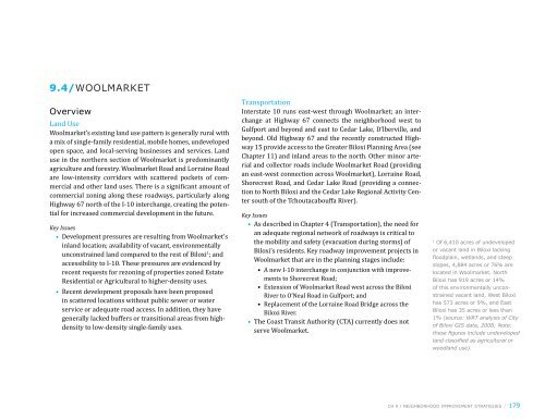
Transportation<br />
Interstate 10 runs east-west through Woolmarket; an interchange<br />
at Highway 67 connects the neighborhood west to<br />
Gulfport and beyond and east to Cedar Lake, D’lberville, and<br />
beyond. Old Highway 67 and the recently constructed Highway<br />
15 provide access to the Greater <strong>Biloxi</strong> Planning Area (see<br />
Chapter 11) and inland areas to the north. Other minor arterial<br />
and collector roads include Woolmarket Road (providing<br />
an east-west connection across Woolmarket), Lorraine Road,<br />
Shorecrest Road, and Cedar Lake Road (providing a connection<br />
to North <strong>Biloxi</strong> and the Cedar Lake Regional Activity Center<br />
south <strong>of</strong> the Tchoutacabouffa River).<br />
Key Issues<br />
• As described in Chapter 4 (Transportation), the need for<br />
an adequate regional network <strong>of</strong> roadways is critical to<br />
the mobility and safety (evacuation during storms) <strong>of</strong><br />
<strong>Biloxi</strong>’s residents. Key roadway improvement projects in<br />
Woolmarket that are in the planning stages include:<br />
• A new I-10 interchange in conjunction with improvements<br />
to Shorecrest Road;<br />
• Extension <strong>of</strong> Woolmarket Road west across the <strong>Biloxi</strong><br />
River to O’Neal Road in Gulfport; and<br />
• Replacement <strong>of</strong> the Lorraine Road Bridge across the<br />
<strong>Biloxi</strong> River.<br />
• The Coast Transit Authority (CTA) currently does not<br />
serve Woolmarket.<br />
1 <strong>of</strong> 6,410 acres <strong>of</strong> undeveloped<br />
or vacant land in <strong>Biloxi</strong> lacking<br />
floodplain, wetlands, and steep<br />
slopes, 4,884 acres or 76% are<br />
located in woolmarket. north<br />
<strong>Biloxi</strong> has 919 acres or 14%<br />
<strong>of</strong> this environmentally unconstrained<br />
vacant land, West <strong>Biloxi</strong><br />
has 573 acres or 9%, and east<br />
<strong>Biloxi</strong> has 35 acres or less than<br />
1% (source: wRT analysis <strong>of</strong> <strong>City</strong><br />
<strong>of</strong> <strong>Biloxi</strong> GIS data, 2008; Note:<br />
these figures include undeveloped<br />
land classified as agricultural or<br />
woodland use).<br />
ch 9 / neighborhood improvement strategies / 179
10<br />
RENE AV<br />
BONNIE ST<br />
ANN AV<br />
ANDY ST<br />
Dedeaux Road<br />
MOCK ST<br />
CURTIS ST<br />
SHELDON ST<br />
DALLAS ST<br />
RIVER RD<br />
O'NEAL RD<br />
Agriculture or Forestry<br />
LORRAINE RD<br />
Single-Family Residential<br />
OLLIE RD<br />
Multi-Family or Mobile Homes<br />
Office or Service Business<br />
Commercial<br />
Casinos/Hotels/Motels<br />
Institutional or Government<br />
Industrial or Commercial Seafood<br />
Utilities and Infrastructure<br />
Parks and Recreation<br />
Preserved Open Space<br />
180 / biloxi comprehensive plan<br />
ROBERTS RD<br />
ROAD 244<br />
Undeveloped Land, Vacant Land or Building<br />
Data Sources: <strong>City</strong> <strong>of</strong> <strong>Biloxi</strong>, MS GIS Data, MARIS<br />
JOHN LEE RD<br />
ROAD 243<br />
PIN OAK DR<br />
SHORECREST RD<br />
JOHN LEE RD<br />
OAKLAWN RD<br />
N MILL CREEK DR<br />
HILLSIDE RD<br />
N OAKLAWN RD<br />
SCENIC RIVER DR<br />
figure <strong>9.4</strong>.1/woolmarket existing land use (2008)<br />
DIXIE AV<br />
STELLA AV<br />
VICTORY LN<br />
COUNTRY LN<br />
Woolmarket<br />
AIRPORT RD<br />
BOSS HUSLEY RD<br />
RIVER OAKS CT<br />
W OAKLAWN RD<br />
RUE MASON<br />
N OAKLAWN LN<br />
POPP'S FERRY RD<br />
JIM BYRD RD<br />
HWY 67<br />
AUBURN DR<br />
GREENHILL CIR<br />
JACK GRAVES RD<br />
BEVERIN RD<br />
BAYWOOD DR<br />
RUSTWOOD DR<br />
N COUNTRY CLUB LN<br />
LACKLAND DR<br />
HOLLY HILLS DR<br />
State Hwy 67<br />
HUSLEY RD<br />
10<br />
ROAD 537<br />
LAKEWOOD PL<br />
CAMP WILKES RD<br />
N 11TH ST<br />
11TH ST<br />
HOLLEE DR<br />
LARKIN DR<br />
<strong>WOOLMARKET</strong> RD<br />
VEE ST<br />
TEE ST<br />
SPARROW DR<br />
SOUTH HILL RD<br />
WREN PL<br />
CAMPBELL DR<br />
JAM LN<br />
TYLER ST<br />
BRASHER RD<br />
HATTIE K RD<br />
ROAD 103<br />
RICHARD DR<br />
WELLS DR<br />
HUDSON-KROHN RD<br />
N BEND DR<br />
EASY LN<br />
POPP'S FERRY RD<br />
CEDAR LAKE RD<br />
MASON RD<br />
North <strong>Biloxi</strong><br />
OLD HWY 67<br />
I-10<br />
PARADISE LN<br />
STARKS RD<br />
W GAY RD S<br />
HWY 15<br />
Popps Ferry Road<br />
Rodriquez St<br />
0 1500 3000 9000 feet<br />
110
10<br />
RENE AV<br />
BONNIE ST<br />
ANN AV<br />
ANDY ST<br />
Dedeaux Road<br />
MOCK ST<br />
CURTIS ST<br />
SHELDON ST<br />
DALLAS ST<br />
RIVER RD<br />
O'NEAL RD<br />
LORRAINE RD<br />
CTA Bus Routes<br />
Proposed Off Road Path<br />
Existing Shared Path<br />
Proposed Shared Path<br />
Proposed Bicycle Lane<br />
Roadway Improvements<br />
New Connections<br />
Major Arterials<br />
Data Sources: <strong>City</strong> <strong>of</strong> <strong>Biloxi</strong>, MS GIS Data, MARIS<br />
JOHN LEE RD<br />
OLLIE RD<br />
ROBERTS RD<br />
ROAD 244<br />
ROAD 243<br />
PIN OAK DR<br />
SHORECREST RD<br />
JOHN LEE RD<br />
OAKLAWN RD<br />
DIXIE AV<br />
N MILL CREEK DR<br />
HILLSIDE RD<br />
STELLA AV<br />
N OAKLAWN RD<br />
SCENIC RIVER DR<br />
Future Shorecrest /<br />
I-10 Interchage<br />
VICTORY LN<br />
COUNTRY LN<br />
Woolmarket<br />
AIRPORT RD<br />
BOSS HUSLEY RD<br />
RIVER OAKS CT<br />
W OAKLAWN RD<br />
RUE MASON<br />
N OAKLAWN LN<br />
POPP'S FERRY RD<br />
JIM BYRD RD<br />
HWY 67<br />
AUBURN DR<br />
GREENHILL CIR<br />
JACK GRAVES RD<br />
BEVERIN RD<br />
BAYWOOD DR<br />
RUSTWOOD DR<br />
N COUNTRY CLUB LN<br />
LACKLAND DR<br />
HOLLY HILLS DR<br />
State Hwy 67<br />
HUSLEY RD<br />
10<br />
ROAD 537<br />
LAKEWOOD PL<br />
CAMP WILKES RD<br />
N 11TH ST<br />
11TH ST<br />
HOLLEE DR<br />
LARKIN DR<br />
<strong>WOOLMARKET</strong> RD<br />
VEE ST<br />
TEE ST<br />
SPARROW DR<br />
SOUTH HILL RD<br />
WREN PL<br />
CAMPBELL DR<br />
JAM LN<br />
TYLER ST<br />
BRASHER RD<br />
HATTIE K RD<br />
ROAD 103<br />
RICHARD DR<br />
WELLS DR<br />
HUDSON-KROHN RD<br />
N BEND DR<br />
EASY LN<br />
POPP'S FERRY RD<br />
North <strong>Biloxi</strong><br />
figure <strong>9.4</strong>.2/woolmarket existing transportation network with planned/proposed improvements<br />
CEDAR LAKE RD<br />
MASON RD<br />
OLD HWY 67<br />
I-10<br />
PARADISE LN<br />
STARKS RD<br />
W GAY RD S<br />
HWY 15<br />
Popps Ferry Road<br />
Rodriquez St<br />
0 1500 3000 9000 feet<br />
110<br />
ch 9 / neighborhood improvement strategies / 181
182 / biloxi comprehensive plan<br />
Natural, Historic, and Cultural Resources<br />
Woolmarket’s boundaries are partly defined by Tchoutacabouffa<br />
and <strong>Biloxi</strong> Rivers. Significant floodplain and wetland<br />
resources occur along these rivers and several tributary<br />
streams. In general, elevations are higher and there is more<br />
environmentally unconstrained land in Woolmarket north <strong>of</strong><br />
I-10 than in other areas <strong>of</strong> <strong>Biloxi</strong>. However, developed properties<br />
south <strong>of</strong> I-10 along the Tchoutacabouffa <strong>Biloxi</strong> River suffered<br />
significant storm damage during Hurricane Katrina.<br />
Key Issues<br />
• Continued development in flood hazard areas increases<br />
Woolmarket’s vulnerability to future storms.<br />
• Private sewage systems in rural areas <strong>of</strong> Woolmarket can<br />
have significant water quality impacts.<br />
• Forested and agricultural lands in northern Woolmarket<br />
at the fringe between the <strong>City</strong> and DeSoto National<br />
Forest to the north form a “greenbelt” that provides a<br />
natural “edge” to development and helps maintain water<br />
quality. As <strong>Biloxi</strong> grows to the north, these important<br />
resources should be maintained by focusing development<br />
into compact centers consistent with the Land Use<br />
Element (Chapter 3).<br />
Community Facilities and Services<br />
South <strong>of</strong> I-10, Woolmarket is served by public sewer and water.<br />
Existing development north <strong>of</strong> I-10 is served by private<br />
wells, on-lot sewage systems, and a limited number <strong>of</strong> neighborhood<br />
treatment systems. The <strong>City</strong> has a program to extend<br />
water and sewer lines along Highway 67 into currently unserved<br />
areas <strong>of</strong> Woolmarket over the next five years. In addition,<br />
the Harrison County Utility Authority is planning to construct<br />
a new wastewater treatment plant to serve the area.<br />
The <strong>Biloxi</strong> Fire Department operates Fire District 8 in Woolmarket.<br />
The Department is planning to develop three new<br />
stations, each with a 1.5-mile radius coverage area, as Woolmarket<br />
develops. The Woolmarket Library, Woolmarket Elementary<br />
School, and the Cedar Lake Christian Academy are<br />
located in Woolmarket. The neighborhood lacks public parks<br />
and recreational facilities, an issue <strong>of</strong> concern for residents.<br />
Key Issues<br />
• The planned water and sewer improvements and new<br />
wastewater treatment plant will greatly increase development<br />
pressures in the Woolmarket area. Water and<br />
sewer line extensions should be planned to support<br />
compact, mixed-use centers consistent with the Future<br />
Land Use Plan and to discourage sprawling development<br />
patterns.<br />
• Woolmarket lacks a full complement <strong>of</strong> community facilities.<br />
There is an opportunity to provide parks, trails, and<br />
other facilities incorporated into a pattern <strong>of</strong> mixed-use<br />
centers and neighborhoods as the area develops.
10<br />
RENE AV<br />
BONNIE ST<br />
ANN AV<br />
ANDY ST<br />
Dedeaux Road<br />
MOCK ST<br />
CURTIS ST<br />
SHELDON ST<br />
DALLAS ST<br />
RIVER RD<br />
O'NEAL RD<br />
Velocity Flood Zone<br />
100-year Flood Plain<br />
500-year Flood Plain<br />
Wetland<br />
River/Waterway<br />
Data Sources: <strong>City</strong> <strong>of</strong> <strong>Biloxi</strong>, MS GIS Data, MARIS<br />
LORRAINE RD<br />
JOHN LEE RD<br />
OLLIE RD<br />
ROBERTS RD<br />
ROAD 244<br />
ROAD 243<br />
PIN OAK DR<br />
W OAKLAWN RD<br />
figure <strong>9.4</strong>.3/woolmarket natural, historic, and cultural resources<br />
SHORECREST RD<br />
JOHN LEE RD<br />
OAKLAWN RD<br />
DIXIE AV<br />
N MILL CREEK DR<br />
HILLSIDE RD<br />
STELLA AV<br />
VICTORY LN<br />
COUNTRY LN<br />
Woolmarket<br />
N OAKLAWN RD<br />
SCENIC RIVER DR<br />
AIRPORT RD<br />
BOSS HUSLEY RD<br />
RIVER OAKS CT<br />
RUE MASON<br />
N OAKLAWN LN<br />
POPP'S FERRY RD<br />
JIM BYRD RD<br />
HWY 67<br />
AUBURN DR<br />
GREENHILL CIR<br />
JACK GRAVES RD<br />
BEVERIN RD<br />
BAYWOOD DR<br />
RUSTWOOD DR<br />
N COUNTRY CLUB LN<br />
LACKLAND DR<br />
HOLLY HILLS DR<br />
State Hwy 67<br />
HUSLEY RD<br />
10<br />
ROAD 537<br />
LAKEWOOD PL<br />
CAMP WILKES RD<br />
N 11TH ST<br />
11TH ST<br />
HOLLEE DR<br />
LARKIN DR<br />
<strong>WOOLMARKET</strong> RD<br />
VEE ST<br />
TEE ST<br />
SPARROW DR<br />
SOUTH HILL RD<br />
WREN PL<br />
CAMPBELL DR<br />
JAM LN<br />
TYLER ST<br />
BRASHER RD<br />
HATTIE K RD<br />
ROAD 103<br />
RICHARD DR<br />
WELLS DR<br />
HUDSON-KROHN RD<br />
N BEND DR<br />
EASY LN<br />
POPP'S FERRY RD<br />
North <strong>Biloxi</strong><br />
CEDAR LAKE RD<br />
MASON RD<br />
OLD HWY 67<br />
I-10<br />
PARADISE LN<br />
STARKS RD<br />
W GAY RD S<br />
HWY 15<br />
Popps Ferry Road<br />
Rodriquez St<br />
0 1500 3000 9000 feet<br />
110<br />
ch 9 / neighborhood improvement strategies / 183
10<br />
v<br />
©<br />
n<br />
RENE AV<br />
BONNIE ST<br />
ANN AV<br />
ANDY ST<br />
Dedeaux Road<br />
MOCK ST<br />
CURTIS ST<br />
SHELDON ST<br />
DALLAS ST<br />
RIVER RD<br />
O'NEAL RD<br />
Medical Services<br />
Public Library<br />
Fire Station<br />
School<br />
OLLIE RD<br />
LORRAINE RD<br />
figure <strong>9.4</strong>.4/woolmarket community facilities<br />
184 / biloxi comprehensive plan<br />
ROBERTS RD<br />
Data Sources: <strong>City</strong> <strong>of</strong> <strong>Biloxi</strong>, MS GIS Data, MARIS, Gulf Coast Community<br />
Design Studio<br />
JOHN LEE RD<br />
ROAD 244<br />
ROAD 243<br />
PIN OAK DR<br />
SHORECREST RD<br />
JOHN LEE RD<br />
n<br />
OAKLAWN RD<br />
©<br />
DIXIE AV<br />
N MILL CREEK DR<br />
HILLSIDE RD<br />
STELLA AV<br />
N OAKLAWN RD<br />
SCENIC RIVER DR<br />
VICTORY LN<br />
COUNTRY LN<br />
AIRPORT RD<br />
BOSS HUSLEY RD<br />
RIVER OAKS CT<br />
W OAKLAWN RD<br />
POPP'S FERRY RD<br />
JIM BYRD RD<br />
FD DISTRICT 8<br />
Woolmarket<br />
©<br />
RUE MASON<br />
N OAKLAWN LN<br />
HWY 67<br />
AUBURN DR<br />
n<br />
GREENHILL CIR<br />
JACK GRAVES RD<br />
BEVERIN RD<br />
FD DISTRICT 9<br />
BAYWOOD DR<br />
RUSTWOOD DR<br />
N COUNTRY CLUB LN<br />
LACKLAND DR<br />
HOLLY HILLS DR<br />
State Hwy 67<br />
HUSLEY RD<br />
10<br />
LAKEWOOD PL<br />
CAMP WILKES RD<br />
N 11TH ST<br />
11TH ST<br />
HOLLEE DR<br />
LARKIN DR<br />
<strong>WOOLMARKET</strong> RD<br />
VEE ST<br />
TEE ST<br />
SPARROW DR<br />
SOUTH HILL RD<br />
WREN PL<br />
CAMPBELL DR<br />
JAM LN<br />
TYLER ST<br />
BRASHER RD<br />
HATTIE K RD<br />
ROAD 103<br />
RICHARD DR<br />
WELLS DR<br />
HUDSON-KROHN RD<br />
N BEND DR<br />
EASY LN<br />
POPP'S FERRY RD<br />
North <strong>Biloxi</strong><br />
CEDAR LAKE RD<br />
MASON RD<br />
OLD HWY 67<br />
I-10<br />
PARADISE LN<br />
STARKS RD<br />
W GAY RD S<br />
HWY 15<br />
Popps Ferry Road<br />
Rodriquez St<br />
0 1500 3000 9000 feet<br />
110<br />
n<br />
n
Housing<br />
The predominant housing type in Woolmarket is large lot, single-family<br />
residential. There are scattered pockets <strong>of</strong> mobile<br />
homes and multi-family development.<br />
Key Issues<br />
• Housing is currently limited in Woolmarket due to its<br />
rural, undeveloped character. However, the large amount<br />
<strong>of</strong> vacant, environmentally unconstrained land creates<br />
the potential for significant new housing development.<br />
The form this development will take is a key question for<br />
Woolmarket’s future. Possibilities include:<br />
• (1) A continuation <strong>of</strong> the existing pattern (single-family<br />
homes on large lots);<br />
• (2) The pattern suggested by recent development<br />
proposals (scattered, disconnected pockets <strong>of</strong> higher<br />
density single-family, multi-family, and mobile home<br />
uses); or<br />
• (3) A new pattern consisting <strong>of</strong> higher density housing<br />
in mixed-use centers with transitions to surrounding<br />
lower density, single-family development.<br />
Economic Development<br />
Woolmarket’s present contribution to <strong>Biloxi</strong>’s economy is relatively<br />
small due to a land use pattern consisting primarily <strong>of</strong><br />
low-density residential homes; scattered, small-sale commercial<br />
uses; and agricultural and undeveloped lands. However,<br />
the large amount <strong>of</strong> (environmentally unconstrained) undeveloped<br />
lands with access to I-10 via the Highway 67, Cedar<br />
Lake Road, and proposed Shorecrest Road interchanges creates<br />
the potential for significant economic development in the<br />
future.<br />
Key Issues<br />
• Reserve land near the I-10 interchanges for high value,<br />
quality retail, and employment uses as opposed to the<br />
“strip” commercial development typical <strong>of</strong> I-10 interchanges<br />
elsewhere in the region.<br />
• Determine suitable location for a future employment/<br />
light industrial center linked to the aerospace, Keesler<br />
AFB, and shipbuilding industries.<br />
figure <strong>9.4</strong>.5/housing and density concepts<br />
(1) Continuation <strong>of</strong> established pattern: Single-family homes<br />
(2) Recent Development Pattern: Lower density adjacent to higher density residential<br />
(3) New Pattern: Lower density with transition to medium and high density residential<br />
ch 9 / neighborhood improvement strategies / 185
186 / biloxi comprehensive plan<br />
woolmarket concept<br />
The goal <strong>of</strong> the Woolmarket Neighborhood Improvement<br />
Strategy is to promote a coherent land use pattern structured<br />
around compact, mixed-use centers whose development is coordinated<br />
with the efficient extension <strong>of</strong> public facilities and<br />
services as the area grows. A primary focus <strong>of</strong> this strategy is<br />
to establish a Regional Activity Center in the northwest quadrant<br />
<strong>of</strong> the Highway 67/I-10 interchange, which is located outside<br />
<strong>of</strong> the 100-year floodplain. Referred to as the Woolmarket<br />
Regional Activity Center, this area is envisioned as a quality<br />
planned development with a mix <strong>of</strong> uses (regional and community-oriented<br />
retail and services, medium to high-density<br />
residential, etc.) that differentiates it from other regional competition<br />
along I-10. New facilities and services (e.g., a community<br />
center, parks and trails, school, etc.) can be incorporated<br />
as the center expands. The center should be walkable, have<br />
a connected street network, and transition smoothly from a<br />
higher density core to surrounding, lower density residential<br />
areas. The compact nature <strong>of</strong> this type <strong>of</strong> development is an<br />
efficient and economical use <strong>of</strong> limited infrastructure dollars.<br />
Woolmarket Vision<br />
Grow a quality, mixed-use regional<br />
activity center and one <strong>of</strong> <strong>Biloxi</strong>’s<br />
vital economic hubs, surrounded by<br />
and connected to stable neighborhoods<br />
with reduced risk from storm<br />
damage and flooding.<br />
Additional mixed-use centers will be developed as Woolmarket<br />
grows. Logical locations designated on the Future Land<br />
Use Map include neighborhood centers at the Lorraine Avenue/Woolmarket<br />
Road and Cedar Lake Road/Old Highway<br />
67 intersections and a potential Regional Activity Center at<br />
Shorecrest Road/I-10 if an interchange is constructed at this<br />
location in the future. Focusing development in centers will<br />
allow lower density residential and rural uses to remain as<br />
part <strong>of</strong> Woolmarket’s overall land use pattern. The concept<br />
also includes possible development <strong>of</strong> a business and/or light<br />
industrial park related to regional industry clusters such as<br />
aerospace and shipbuilding in the Woolmarket Regional Activity<br />
Center or other location with good access to I-10.
10<br />
RENE AV<br />
BONNIE ST<br />
ANN AV<br />
ANDY ST<br />
Dedeaux Road<br />
MOCK ST<br />
CURTIS ST<br />
SHELDON ST<br />
DALLAS ST<br />
RIVER RD<br />
O'NEAL RD<br />
LORRAINE RD<br />
figure <strong>9.4</strong>.6/woolmarket concept map<br />
OLLIE RD<br />
Neighborhood Center<br />
Major Arterials<br />
Major Intersection<br />
ROBERTS RD<br />
Roadway Improvements<br />
New Connections<br />
Predominantly Residential<br />
Mixed Uses<br />
Existing Agricultural Zoning<br />
Future Greenway<br />
Conservation Development<br />
Velocity Zone<br />
100 Year Flood<br />
JOHN LEE RD<br />
ROAD 244<br />
ROAD 243<br />
PIN OAK DR<br />
SHORECREST RD<br />
JOHN LEE RD<br />
OAKLAWN RD<br />
DIXIE AV<br />
N MILL CREEK DR<br />
HILLSIDE RD<br />
STELLA AV<br />
N OAKLAWN RD<br />
SCENIC RIVER DR<br />
VICTORY LN<br />
COUNTRY LN<br />
AIRPORT RD<br />
BOSS HUSLEY RD<br />
RIVER OAKS CT<br />
Major<br />
Mixed<br />
Use<br />
Center<br />
W OAKLAWN RD<br />
RUE MASON<br />
N OAKLAWN LN<br />
POPP'S FERRY RD<br />
JIM BYRD RD<br />
HWY 67<br />
AUBURN DR<br />
GREENHILL CIR<br />
JACK GRAVES RD<br />
BEVERIN RD<br />
BAYWOOD DR<br />
RUSTWOOD DR<br />
N COUNTRY CLUB LN<br />
LACKLAND DR<br />
HOLLY HILLS DR<br />
State Hwy 67<br />
HUSLEY RD<br />
10<br />
ROAD 537<br />
CAMP WILKES RD<br />
N 11TH ST<br />
11TH ST<br />
HOLLEE DR<br />
LARKIN DR<br />
<strong>WOOLMARKET</strong> RD<br />
VEE ST<br />
TEE ST<br />
SPARROW DR<br />
CAMP CAMP FOUR FOUR JACKS JACKS RD. RD.<br />
POPPS POPPS FERRY FERRY ROAD ROAD<br />
WREN PL<br />
Woolmarket<br />
LAKEWOOD PL<br />
CAMPBELL DR<br />
POPPS POPPS FERRY FERRY ROAD ROAD<br />
SOUTH HILL RD<br />
JAM JAM LANE LANE<br />
JAM LN<br />
TYLER ST<br />
BRASHER RD<br />
HATTIE K RD<br />
ROAD 103<br />
RICHARD DR<br />
WELLS DR<br />
HUDSON-KROHN RD<br />
N BEND DR<br />
EASY LN<br />
POPP'S FERRY RD<br />
North <strong>Biloxi</strong><br />
CEDAR LAKE RD<br />
MASON RD<br />
OLD HWY 67<br />
I-10<br />
PARADISE LN<br />
STARKS RD<br />
W GAY RD S<br />
HWY 15<br />
Popps Ferry Road<br />
Rodriquez St<br />
0 1500 3000 9000 feet<br />
110<br />
ch 9 / neighborhood improvement strategies / 187
188 / biloxi comprehensive plan<br />
woolmarket strategies<br />
Strategy 1<br />
Organize land use and development patterns around a Regional<br />
Activity Center focused on the I-10/Highway 67 interchange<br />
and other, smaller centers as Woolmarket grows.<br />
Priority Actions<br />
• Enact a Planned Development – Commercial (PD-C)<br />
zoning district to encourage development <strong>of</strong> the<br />
Woolmarket Regional Activity Center and a second<br />
Regional Activity Center at Shorecrest Road/I-10 if an<br />
interchange is constructed at this location in the future.<br />
• Enact a Planned Development – Traditional<br />
Neighborhood Development (PD-TND) District to<br />
encourage the development <strong>of</strong> smaller-scale “village<br />
centers” in appropriate locations.<br />
• Explore with CTA the possibility <strong>of</strong> providing future transit<br />
service for the Woolmarket Regional Activity Center<br />
and other designated centers as they are developed.<br />
Strategy 2<br />
Coordinate planning and development <strong>of</strong> public infrastructure<br />
improvements (multi-modal roadway improvements, water<br />
and sewer service) with the proposed centers (as opposed<br />
to promoting scattered, disconnected developments through<br />
piecemeal extension projects).<br />
Priority Actions<br />
• Prioritize the <strong>City</strong>’s sewer and water improvement<br />
projects in Woolmarket to serve the designated center<br />
locations.<br />
• Implement “Complete Street” improvements to<br />
Highway 67 between I-10 and Woolmarket Road and to<br />
Woolmarket Road in the vicinity <strong>of</strong> the Highway 67 intersection<br />
to encourage multi-modal access (walking, biking,<br />
and potential future transit service as well as driving).<br />
Strategy 3<br />
Restrict development and limit disturbance to waterways,<br />
wetlands, natural habitat, floodplains, and other environmentally<br />
sensitive areas, especially south <strong>of</strong> I-10. Address open<br />
space and the benefits provided by “green infrastructure” as<br />
part <strong>of</strong> Woolmarket’s land use and development pattern north<br />
<strong>of</strong> I-10.<br />
Priority Actions<br />
• Incorporate mechanisms such as conservation cluster<br />
subdivisions and common open space set-asides into the<br />
LDO to promote protection <strong>of</strong> open space and environmentally<br />
sensitive areas.<br />
• Develop greenway corridors/connections to the<br />
Tchoutacabouffa and <strong>Biloxi</strong> Rivers as part <strong>of</strong> a citywide<br />
greenway network.<br />
• Identify opportunities to partner with the Land Trust for<br />
the Mississippi Coastal Plain to preserve valuable natural<br />
resource lands as open space.<br />
• Encourage sustainable, low impact site design and<br />
stormwater best management practices to minimize<br />
development impacts on Woolmarket’s sensitive environmental<br />
resources.
Strategy 4<br />
Address the needs <strong>of</strong> Woolmarket residents for community<br />
facilities and services, including:<br />
• A new community park/community center<br />
• Neighborhood parks and playground equipment<br />
• Neighborhood schools to serve a growing population<br />
• Fire and emergency services<br />
Priority Actions<br />
• Identify a location for and develop a new community<br />
park/center in or near the Woolmarket Regional Activity<br />
Center to provide a focus for community activity.<br />
• Work with the <strong>Biloxi</strong> Fire Department to identify locations<br />
for the planned fire stations in or near centers<br />
designated on the Future Land Use Plan. Explore the<br />
possibility <strong>of</strong> providing community-serving space (e.g.,<br />
meeting rooms) in the new stations.<br />
• Work with the Harrison County School District to coordinate<br />
planning for future school facilities with the designated<br />
center locations.<br />
Strategy 5<br />
Develop a network <strong>of</strong> streets and pedestrian/bicycle facilities<br />
in Woolmarket that connect to the centers designated on the<br />
Future Land Use Plan.<br />
Priority Actions<br />
• Construct sidewalks along existing and new streets with<br />
connections to the Woolmarket Regional Activity Center<br />
and other centers to promote increased pedestrian usage.<br />
• Develop a system <strong>of</strong> shared roadways, bicycle lanes,<br />
and <strong>of</strong>f-road paths in Woolmarket as part <strong>of</strong> a citywide<br />
bicycle network.<br />
Strategy 6<br />
Through the proposed <strong>Biloxi</strong> Economic Development Committee<br />
(see Chapter 8), explore the potential to locate a business/<br />
employment park or light industrial park in Woolmarket.<br />
Priority Actions<br />
• Consult with representatives <strong>of</strong> regional industry clusters<br />
(aerospace, shipbuilding, etc.) to identify industry<br />
needs and possibilities for new/spin-<strong>of</strong>f business<br />
development.<br />
• Identify possible sites for a new business/employment<br />
or light industrial park in the Woolmarket Regional<br />
Activity Center or other suitable location with easy access<br />
to I-10.<br />
ch 9 / neighborhood improvement strategies / 189
190 / biloxi comprehensive plan