Beauvoir - City of Biloxi
Beauvoir - City of Biloxi
Beauvoir - City of Biloxi
You also want an ePaper? Increase the reach of your titles
YUMPU automatically turns print PDFs into web optimized ePapers that Google loves.
156 / biloxi comprehensive plan<br />
9.2/west biloxi<br />
overview<br />
Land Use<br />
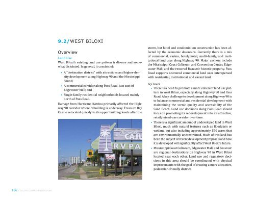
West <strong>Biloxi</strong>’s existing land use pattern is diverse and somewhat<br />
disjointed. In general, it consists <strong>of</strong>:<br />
• A “destination district” with attractions and higher-density<br />
development along Highway 90 and the Mississippi<br />
Sound;<br />
• A commercial corridor along Pass Road, just east <strong>of</strong><br />
Edgewater Mall; and<br />
• Single-family residential neighborhoods located mainly<br />
north <strong>of</strong> Pass Road.<br />
Damage from Hurricane Katrina primarily affected the Highway<br />
90 corridor where rebuilding is underway. Treasure Bay<br />
Casino relocated quickly to its upper building levels after the<br />
storm, but hotel and condominium construction has been affected<br />
by the economic downturn. Currently there is a mix<br />
<strong>of</strong> commercial, casino, hotel/motel, multi-family, and institutional<br />
land uses along Highway 90. Major anchors include<br />
the Mississippi Coast Coliseum and Convention Center, Edgewater<br />
Mall, and the restored <strong>Beauvoir</strong> historic property. Pass<br />
Road supports scattered commercial land uses interspersed<br />
with residential, institutional, and vacant land.<br />
Key Issues<br />
• There is a need to promote a more coherent land use pattern<br />
in West <strong>Biloxi</strong>, especially along Highway 90 and Pass<br />
Road. A key challenge to development along Highway 90 is<br />
to balance commercial and residential development with<br />
maintaining the scenic quality and accessibility <strong>of</strong> the<br />
Sand Beach. Land use decisions along Pass Road should<br />
focus on promoting its redevelopment into an attractive,<br />
retail/mixed-use corridor over time.<br />
• There is a significant amount <strong>of</strong> undeveloped land in West<br />
<strong>Biloxi</strong>, much with natural features such as floodplain or<br />
wetland but also including approximately 570 acres that<br />
are environmentally unconstrained. Much <strong>of</strong> this land has<br />
been the subject <strong>of</strong> recent development proposals and how<br />
it is developed will significantly affect West <strong>Biloxi</strong>’s future.<br />
• Mississippi Coast Coliseum, Edgewater Mall, and <strong>Beauvoir</strong><br />
are regional destinations on Highway 90 in West <strong>Biloxi</strong><br />
located near each other. Land use and regulatory decisions<br />
in this area should be coordinated with physical<br />
improvements with the goal <strong>of</strong> creating a more attractive,<br />
pedestrian-friendly district.
E PASS RD<br />
DEBUYS RD<br />
EULA ST<br />
COVE DR<br />
CT SWITZER SR DR<br />
EISENHOWER DR<br />
AUDUBON PL<br />
KENMORE AV<br />
OLD BAY RD<br />
MARCIA CT<br />
BALMORAL AV<br />
MARSHALL RD<br />
CARTER RD<br />
BAY VISTA DR<br />
RICH AV<br />
PASS RD<br />
figure 9.2.1/west biloxi existing land use (2008)<br />
BRIARFIELD AV<br />
CASTILLE PL PARK DR<br />
BEACH VIEW AV<br />
OAKMONT PL<br />
ATKINSON RD<br />
ALICE DR<br />
JIM MONEY RD<br />
GREATER AV<br />
IRIS ST<br />
SOUTHERN AV<br />
US Hwy 90<br />
WEST DR<br />
HILLER DR<br />
ALTHEA ST<br />
EAST DR<br />
BAKER ST<br />
Mississippi Sound<br />
<strong>Biloxi</strong> Back Bay<br />
STONE<br />
VETERANS AV<br />
GARFIELD AV<br />
MCDONNELL AV<br />
MOSS AV<br />
STATE ST<br />
TRAVIA AV<br />
RODENBERG AV<br />
SHIRLEY CT<br />
ST MARY BLVD<br />
VINE ST<br />
IBERVILLE DR<br />
ACACIA AV<br />
SYLVANIA ST<br />
MILLER ST<br />
WILKES AV<br />
Agriculture or Forestry<br />
Single-Family Residential<br />
Multi-Family or Mobile Homes<br />
Office or Service Business<br />
Commercial<br />
Casinos/Hotels/Motels<br />
Institutional or Government<br />
Industrial or Commercial Seafood<br />
Utilities and Infrastructure<br />
Parks and Recreation<br />
Preserved Open Space<br />
Undeveloped Land<br />
Vacant Buildings/Land<br />
Data Sources: <strong>City</strong> <strong>of</strong> <strong>Biloxi</strong>, MS GIS Data, MARIS,<br />
Gulf Coast Community Design Studio<br />
Proposed or Permitted Condo<br />
Projects 2005 - 2008<br />
0 1000 2000 6000 feet<br />
ch 9 / neighborhood improvement strategies / 157
158 / biloxi comprehensive plan<br />
Transportation<br />
Highway 90 and Pass Road are major east-west connections in<br />
West <strong>Biloxi</strong>, with Highway 90 being the only continuous link<br />
between West and East <strong>Biloxi</strong>. Storm damage from Hurricane<br />
Katrina rendered Highway 90 impassable for an extended period<br />
<strong>of</strong> time but the roadway has been reconstructed with improved<br />
pedestrian/bicycle connections. Popp’s Ferry Road is<br />
West <strong>Biloxi</strong>’s only north-south connector across Back Bay. An<br />
active CSX rail line cuts east-west across West <strong>Biloxi</strong> and has<br />
been proposed as a future multi-modal transportation corridor.<br />
Coast Transit Authority (CTA) provides a Route 24/Keesler<br />
Express bus route that connects residents <strong>of</strong> West <strong>Biloxi</strong><br />
to jobs at Keesler Air Force Base via Pass Road.<br />
Key Issues<br />
• Keesler Air Force Base and the Back Bay <strong>of</strong> <strong>Biloxi</strong> are<br />
physical barriers that restrict vehicular connections from<br />
West <strong>Biloxi</strong> to East and North <strong>Biloxi</strong>. Improving transportation<br />
corridors within West <strong>Biloxi</strong> and connections from<br />
West <strong>Biloxi</strong> to inland routes is crucial to timely evacuations<br />
during storm events as well as easing peak hour<br />
congestion. Priority transportation projects include:<br />
• Extension <strong>of</strong> Popp’s Ferry Road to Highway 90 timed<br />
with the expansion <strong>of</strong> the Coliseum<br />
• Widening <strong>of</strong> the Popp’s Ferry bridge<br />
• Roadway improvements along Pass Road and<br />
Highway 90<br />
• Improving multi-modal transportation options, including<br />
pedestrian, bicycle, and transit service, is a priority for<br />
West <strong>Biloxi</strong>. Long-range transit improvements proposed<br />
in CTA’s Gulf Coast Transit Development Plan include a<br />
Coliseum District Streetcar Line serving the West <strong>Biloxi</strong><br />
Convention Center District and east-west bus rapid<br />
transit or high-speed rail service along the existing CSX<br />
railroad corridor.
E PASS RD<br />
DEBUYS RD<br />
EULA ST<br />
COVE DR<br />
CT SWITZER SR DR<br />
EISENHOWER DR<br />
AUDUBON PL<br />
KENMORE AV<br />
OLD BAY RD<br />
MARCIA CT<br />
BALMORAL AV<br />
MARSHALL RD<br />
CARTER RD<br />
BRIARFIELD AV<br />
CASTILLE PL PARK DR<br />
BAY VISTA DR<br />
RICH AV<br />
PASS RD<br />
BEACH VIEW AV<br />
OAKMONT PL<br />
POPP'S FERRY RD<br />
ATKINSON RD<br />
JIM MONEY RD<br />
West <strong>Biloxi</strong><br />
GREATER AV<br />
IRIS ST<br />
SOUTHERN AV<br />
figure 9.2.2/west biloxi existing transportation network with planned/proposed improvements<br />
ALICE DR<br />
US Hwy 90<br />
HILLER DR<br />
ALTHEA ST<br />
EAST DR<br />
STONE<br />
VETERANS AV<br />
GARFIELD AV<br />
MCDONNELL AV<br />
MOSS AV<br />
STATE ST<br />
TRAVIA AV<br />
RODENBERG AV<br />
SHIRLEY CT<br />
ST MARY BLVD<br />
VINE ST<br />
IBERVILLE DR<br />
ACACIA AV<br />
Keesler Air<br />
Force Base<br />
SYLVANIA ST<br />
MILLER ST<br />
WILKES AV<br />
Existing Bus Service<br />
Proposed Bus Service<br />
Transit Center<br />
Proposed Street Car<br />
Proposed Off Road Path<br />
Proposed Bicycle Lane<br />
Proposed Shared Path<br />
<strong>Biloxi</strong> Peninsula Path<br />
Existing Cargo Rail<br />
Roadway Improvements<br />
New Connections<br />
Data Sources: <strong>City</strong> <strong>of</strong> <strong>Biloxi</strong>, MS GIS Data, MARIS<br />
0 1000 2000 6000 feet<br />
ch 9 / neighborhood improvement strategies / 159
160 / biloxi comprehensive plan<br />
Natural, Historic, and Cultural Resources<br />
The Mississippi Sound and Back Bay <strong>of</strong> <strong>Biloxi</strong> form West<br />
<strong>Biloxi</strong>’s southern and northern boundaries, providing a scenic<br />
context for development. While most <strong>of</strong> West <strong>Biloxi</strong> is located<br />
outside <strong>of</strong> designated flood hazard areas, the south side<br />
<strong>of</strong> Highway 90 and portions <strong>of</strong> the north side fall within the<br />
Velocity Zone. In addition, areas between Pass Road and the<br />
CSX rail line are located within the 100-year floodplain, as are<br />
areas along the Back Bay. Edgewater Park, Hiller Park, and<br />
President Broadwater Golf Club are the largest open space<br />
features in West <strong>Biloxi</strong> and home to many live oak trees. Other<br />
important natural resources in East <strong>Biloxi</strong> include the Sand<br />
Beach and wetlands located along the Back Bay and in lowlying<br />
areas between Pass Road and the CSX line.<br />
Historic and cultural resources in West <strong>Biloxi</strong> include Edgewater<br />
Park, the Mississippi Coast Coliseum, the National Cemetery<br />
on the VA property, and <strong>Beauvoir</strong>—an historic mansion,<br />
museum, and library dedicated to preserving the legacy <strong>of</strong><br />
Confederate president Jefferson Davis.<br />
Key Issues<br />
• West <strong>Biloxi</strong>’s natural, historic and cultural resources—including<br />
the Sand Beach, <strong>Beauvoir</strong>, the National Cemetery,<br />
and the Mississippi Coast Coliseum—are regional attractions.<br />
Preserving and promoting these resources is<br />
important to West <strong>Biloxi</strong>’s economy and identity.<br />
• While most <strong>of</strong> West <strong>Biloxi</strong> is higher than East <strong>Biloxi</strong>,<br />
vulnerability to major storms is still a major issue,<br />
particularly along Highway 90. Low-lying wetlands and<br />
other areas within the floodplain perform an important<br />
environmental service by absorbing water during storm<br />
events. In addition, the beach and dunes along the Sand<br />
Beach constitute a natural “line <strong>of</strong> defense.”
DEBUYS RD<br />
EISENHOWER DR<br />
Edgewater<br />
Mall<br />
PASS RD<br />
POPP'S FERRY RD<br />
West <strong>Biloxi</strong><br />
* * * <strong>Beauvoir</strong><br />
Edgewater Mississippi Coast<br />
Park Coliseum and Convention<br />
Center<br />
US Hwy 90<br />
Hiller<br />
*<br />
Park<br />
Broadwater<br />
Golf Course<br />
Mississippi Sound<br />
figure 9.2.3/west biloxi natural, historic, and cultural resources<br />
<strong>Biloxi</strong> Back Bay<br />
National<br />
*<br />
Cemetery (VA<br />
Property)<br />
VETERANS AV<br />
RODENBERG AV<br />
*<br />
Edgewater Park Historic<br />
Overlay District<br />
Local Historic Landmark<br />
Cultural Resources<br />
Velocity Flood Zone<br />
100-Year Flood Plain<br />
500-Year Flood Plain<br />
Wetland<br />
Data Sources: <strong>City</strong> <strong>of</strong> <strong>Biloxi</strong>, MS GIS Data, MARIS<br />
Keesler Air<br />
Force Base<br />
0 1000 2000 6000 feet<br />
ch 9 / neighborhood improvement strategies / 161
162 / biloxi comprehensive plan<br />
Community Facilities and Services<br />
The <strong>Biloxi</strong> Fire Department operates two fire districts in West<br />
<strong>Biloxi</strong> (Fire Districts 4 and 5). In addition, West <strong>Biloxi</strong> is home<br />
to the Veterans Affairs Gulf Coast Veterans Health Care System,<br />
a hospital providing medical and patient care services to<br />
over 50,000 veterans in the region.<br />
West <strong>Biloxi</strong> is fully served by an infrastructure network consisting<br />
<strong>of</strong> water, sanitary sewer, storm sewer, power and telecommunications<br />
systems. These systems, particularly sewer<br />
and water lines within the storm surge area, were damaged<br />
during Hurricane Katrina and are being reconstructed.<br />
<strong>Biloxi</strong>’s Department <strong>of</strong> Parks and Recreation oversees a number<br />
<strong>of</strong> parks in West <strong>Biloxi</strong>, the largest <strong>of</strong> which is Hiller Park,<br />
and the Donal M. Snyder Community Center on Pass Road. The<br />
Sand Beach Trail (proposed by the Comprehensive Plan to be<br />
part <strong>of</strong> a larger Peninsula Path) is a popular pedestrian and<br />
bicycle path in West <strong>Biloxi</strong>. However, West <strong>Biloxi</strong> otherwise<br />
lacks a network <strong>of</strong> paths, open space connections, or bikeways<br />
for public use. The West <strong>Biloxi</strong> Library and five elementary<br />
schools are located in West <strong>Biloxi</strong>.<br />
Key Issues<br />
• Hiller Park is <strong>Biloxi</strong>’s largest park but is relatively<br />
inaccessible as it lacks frontage on a major road. The<br />
Mississippi Renaissance Garden Foundation has plans<br />
to develop a model botanical garden and horticultural<br />
center in this park on land provided by the <strong>City</strong>.<br />
• Aside from the Sand Beach walkway, West <strong>Biloxi</strong> lacks a<br />
continuous open space network <strong>of</strong> greenways and recreational<br />
paths or routes for bicyclists and pedestrians.
DEBUYS RD<br />
EISENHOWER DR<br />
PASS RD<br />
FD DISTRICT 5<br />
POPP'S FERRY RD<br />
n<br />
figure 9.2.4/west biloxi community facilities<br />
n<br />
West <strong>Biloxi</strong><br />
n<br />
US Hwy 90<br />
Hiller Park<br />
FD DISTRICT 4<br />
VETERANS AV<br />
Veterans Affairs Gulf<br />
Coast Veterans Health<br />
Care System<br />
®v<br />
RODENBERG AV<br />
n<br />
n<br />
®v<br />
n<br />
Park or Recreation Area<br />
Public Library<br />
VA Hospital<br />
School<br />
Data Sources: <strong>City</strong> <strong>of</strong> <strong>Biloxi</strong>, MS GIS Data, MARIS, Gulf Coast Community<br />
Design Studio<br />
Keesler Air<br />
Force Base<br />
FD DISTRICT 1<br />
0 1000 2000 6000 feet<br />
ch 9 / neighborhood improvement strategies / 163
164 / biloxi comprehensive plan<br />
Housing<br />
West <strong>Biloxi</strong>’s housing stock is divided into single-family homes<br />
and condominiums/multi-family units that are largely oriented<br />
towards vacationers. Most <strong>of</strong> the single-family homes are<br />
located just east <strong>of</strong> Edgewater Mall and north <strong>of</strong> Pass Road in<br />
stable residential neighborhoods. A majority <strong>of</strong> condominium<br />
and multi-family units are located between Highway 90 and<br />
Pass Road. Many <strong>of</strong> the condominium buildings along Highway<br />
90 were severely damaged or destroyed by Katrina and<br />
numerous permits for new condominium projects have been<br />
issued since the hurricane, although the actual pace <strong>of</strong> construction<br />
has been slow.<br />
Key Issues<br />
• New condominium construction along Highway 90 will<br />
have a major impact on the visual character <strong>of</strong> one <strong>of</strong><br />
<strong>Biloxi</strong>’s prime assets.<br />
• Undeveloped and underutilized land in West <strong>Biloxi</strong><br />
provides the opportunity for new residential and mixeduse<br />
development (e.g., along Pass Road) that can serve<br />
to “knit together” the neighborhood’s fragmented land<br />
use pattern and provide new housing opportunities for<br />
<strong>Biloxi</strong> residents. New housing should be located outside<br />
<strong>of</strong> designated flood risk areas wherever possible.<br />
Economic Development<br />
The “anchors” <strong>of</strong> West <strong>Biloxi</strong>’s economy are Edgewater Mall<br />
(a regional shopping destination); the Mississippi Coast Coliseum<br />
and Convention Center; <strong>Beauvoir</strong>; the Highway 90 and<br />
Pass Road commercial corridors; and the Veterans Administration<br />
Hospital north <strong>of</strong> Pass Road. Many condominiums,<br />
hotels, motels, and other visitor-oriented businesses along<br />
Highway 90 were destroyed by Hurricane Katrina. These have<br />
been slow to rebuild, resulting in a shortfall <strong>of</strong> hotel rooms to<br />
support the Convention Center, which is undergoing a major<br />
expansion <strong>of</strong> is facilities.<br />
Key Issues<br />
• Keys to maintaining and strengthening West <strong>Biloxi</strong>’s role<br />
as an “engine” <strong>of</strong> the <strong>City</strong>’s economy include:<br />
• Promoting the sustainable and orderly redevelopment<br />
<strong>of</strong> its major corridors (Highway 90 and Pass Road);<br />
• Maintaining the viability <strong>of</strong> Edgewater Mall; and<br />
• Supporting the expansion <strong>of</strong> Mississippi Coast Coliseum<br />
and Convention Center (including development <strong>of</strong> additional<br />
hotel rooms).
West <strong>Biloxi</strong> Concept<br />
The neighborhood improvement concept for West <strong>Biloxi</strong> capitalizes<br />
on the regional assets—Edgewater Mall, Mississippi<br />
Coast Coliseum and Convention Center, <strong>Beauvoir</strong>, Highway 90,<br />
Sand Beach, and Pass Road—that define its identity and are its<br />
major contributions to <strong>Biloxi</strong>’s economy. The proximity <strong>of</strong> the<br />
mall, Convention Center, <strong>Beauvoir</strong>, Highway 90 and Sand Beach<br />
creates an opportunity to establish a new “Hospitality Business”<br />
district to replace the existing Convention Center Overlay<br />
District. Along with targeted physical (transportation and<br />
streetscape) improvements, enactment <strong>of</strong> this new district can<br />
promote a more attractive, accessible, and pedestrian-friendly<br />
place with its own unique identity to support the Convention<br />
Center expansion. Major transportation improvements (e.g.,<br />
extension <strong>of</strong> Popp’s Ferry Road to Highway 90 and Highway 90<br />
improvements) should be implemented in a manner that supports<br />
the character <strong>of</strong> the Convention Center District and provides<br />
multi-modal access (i.e., transit, walking, and bicycling in<br />
addition to vehicular travel).<br />
Edgewater Mall’s position as a regional retail destination with<br />
major commercial uses should continue through supportive<br />
zoning and land use policies. Pass Road, currently West <strong>Biloxi</strong>’s<br />
main commercial corridor, can be developed into an attractive<br />
retail/mixed-use corridor through design standards and attention<br />
to the quality <strong>of</strong> redevelopment. Appropriate uses include<br />
neighborhood-oriented retail and services, low-density <strong>of</strong>fice<br />
and pr<strong>of</strong>essional uses, multi-family, and institutional uses. Retail<br />
establishments on Pass Road can complement the regional uses<br />
in Edgewater Mall, <strong>of</strong>fering a different type <strong>of</strong> shopping environment.<br />
Access management (control <strong>of</strong> driveways and curb cuts) is<br />
a major priority for Pass Road to improve traffic flow and safety.<br />
West biloxi Vision<br />
build a stable residential community and quality regional<br />
destination district based on West <strong>Biloxi</strong>’s scenic,<br />
natural, historic, and economic assets.<br />
West <strong>Biloxi</strong> Strategies<br />
Strategy 1<br />
Organize land use and development patterns around 1) a<br />
scenic destination district along Highway 90 and the Mississippi<br />
Sound with anchors at the Mississippi Coast Coliseum,<br />
Edgewater Mall, and <strong>Beauvoir</strong>; 2) an attractive, retail/mixeduse<br />
corridor along Pass Road; and 3) single-family residential<br />
neighborhoods located mostly north <strong>of</strong> Pass Road.<br />
Priority Actions<br />
• As a priority, enact a Beach Boulevard Corridor Overlay<br />
District with design guidelines for new development to<br />
maintain scenic character and views, provide pedestrian<br />
access (sidewalks), and control vehicular access (limit<br />
curb cuts) along the corridor.<br />
• Develop a Pass Road Corridor Overlay District.<br />
Strategy 2<br />
Establish a network <strong>of</strong> pedestrian and bike paths in West<br />
<strong>Biloxi</strong>, including an improved Sand Beach Trail that allows<br />
residents and visitors to recreate safely.<br />
ch 9 / neighborhood improvement strategies / 165
E PASS RD<br />
DEBUYS RD<br />
EULA ST<br />
COVE DR<br />
CT SWITZER SR DR<br />
166 / biloxi comprehensive plan<br />
EISENHOWER DR<br />
KENMORE AV<br />
*<br />
Edgewater<br />
Mall<br />
Coliseum<br />
District<br />
Circulator<br />
AUDUBON PL<br />
OLD BAY RD<br />
MARCIA CT<br />
BALMORAL AV<br />
MARSHALL RD<br />
CARTER RD<br />
BRIARFIELD AV<br />
CASTILLE PL PARK DR<br />
BAY VISTA DR<br />
RICH AV<br />
PASS RD<br />
BEACH VIEW AV<br />
Edgewater<br />
Park<br />
figure 9.2.5/west biloxi concept map<br />
OAKMONT PL<br />
POPP'S FERRY RD<br />
* *<br />
Mississippi<br />
Coast<br />
Coliseum<br />
ATKINSON RD<br />
ALICE DR<br />
JIM MONEY RD<br />
West <strong>Biloxi</strong><br />
<strong>Beauvoir</strong><br />
GREATER AV<br />
IRIS ST<br />
WEST DR<br />
SOUTHERN AV<br />
US Hwy 90<br />
Hiller<br />
Park<br />
HILLER DR<br />
Cavalier<br />
Ball Park<br />
Multimodal Transportation Corridor<br />
*<br />
Treasure<br />
Bay<br />
Casino<br />
ALTHEA ST<br />
EAST DR<br />
STONE<br />
BAKER ST<br />
VETERANS AV<br />
VA Hospital<br />
*<br />
GARFIELD AV<br />
MCDONNELL AV<br />
MOSS AV<br />
STATE ST<br />
TRAVIA AV<br />
RODENBERG AV<br />
SHIRLEY CT<br />
<strong>Biloxi</strong> Peninsula Path<br />
PINE LAWN<br />
ST MARY BLVD<br />
VINE ST<br />
IBERVILLE DR<br />
ACACIA AV<br />
SYLVANIA ST<br />
* Major<br />
Keesler Air<br />
Force Base<br />
MILLER ST<br />
WILKES AV<br />
Major Arterials<br />
Roadway Improvements<br />
New Connections<br />
Predominantly Residential<br />
Mixed Uses<br />
Major Anchors<br />
Intersection<br />
Corridors Overlay District<br />
Planned Development<br />
District-Hospitality Business<br />
Sand Beach Improvements<br />
Multi-use Trails<br />
Velocity Zone<br />
100 Year Flood<br />
0 1000 2000 6000 feet
Priority Actions<br />
• Maintain a continuous public pathway along the Highway<br />
90 corridor (the <strong>Biloxi</strong> Peninsula Path).<br />
• Create greenway connections from the Sand Beach and<br />
the <strong>Biloxi</strong> Peninsula Path to the interior <strong>of</strong> West <strong>Biloxi</strong><br />
and the Back Bay <strong>of</strong> <strong>Biloxi</strong> as part <strong>of</strong> a citywide greenway<br />
system.<br />
• Support implementation <strong>of</strong> the recommendations <strong>of</strong> the<br />
2008 Sand Beach Master Plan by the Harrison County<br />
Sand Beach Authority, including designated public open<br />
spaces (picnic areas, pavilions, splash pool, public pier),<br />
vegetated dunes that contribute to storm protection, and<br />
sensitively sited public parking lots.<br />
Strategy 3<br />
Improve east-west and north-south roadway connections<br />
serving West <strong>Biloxi</strong>.<br />
Priority Actions<br />
Implement the following projects as priorities to improve major<br />
roadway connections to and within West <strong>Biloxi</strong>:<br />
• Popp’s Ferry Road/Popp’s Ferry Bridge improvements<br />
• Extension <strong>of</strong> Popp’s Ferry Road to Highway 90 in coordination<br />
with the Mississippi Coast Coliseum expansion<br />
• Intersection improvements/access management controls<br />
along Pass Road<br />
• Widening <strong>of</strong> Veteran’s Avenue from Highway 90 to Pass<br />
Road from a two-lane to a four-lane divided roadway<br />
• Extension <strong>of</strong> Irish Hill Drive west from Veterans Avenue<br />
to connect to Greater Avenue<br />
• Establishment <strong>of</strong> a multimodal transportation corridor<br />
along the CSX rail line (east-west corridor project) as a<br />
long-term objective<br />
Strategy 4<br />
Implement multimodal street improvements serving residents,<br />
visitors, and employees in West <strong>Biloxi</strong>.<br />
Priority Actions<br />
• Construct pedestrian amenities (sidewalks, protected<br />
crossings at key points to access the Sand Beach, <strong>of</strong>f-road<br />
pathways, etc.).<br />
• Implement bicycle improvements (designated bike lanes<br />
or shared routes along major corridors) as part <strong>of</strong> a citywide<br />
bicycle network.<br />
• Work with CTA to improve transit service in West <strong>Biloxi</strong>,<br />
including the following long-term actions proposed in<br />
the 2007 Gulf Coast Transit Development Plan:<br />
• Streetcar service along Highway 90<br />
• A “Coliseum District Circulator”<br />
• East-west corridor bus rapid transit<br />
• Intercity high-speed rail passenger service using the<br />
existing CSX right-<strong>of</strong>-way<br />
Strategy 5<br />
Support the expansion <strong>of</strong> the Mississippi Coast Coliseum as<br />
a visitor destination with high-quality supporting hospitality<br />
uses such as hotels in the surrounding area. Implement<br />
streetscape improvements to create a walkable, pedestrianfriendly<br />
district.<br />
ch 9 / neighborhood improvement strategies / 167
168 / biloxi comprehensive plan<br />
Priority Actions<br />
• Enact a “Planned Development District—Hospitality<br />
Business” with design standards and incentives that<br />
encourage quality hotel and retail development within<br />
walking distance <strong>of</strong> the Coliseum and <strong>Beauvoir</strong> (to replace<br />
the existing Convention Center Overlay District).<br />
• Work with the Convention and Visitors Bureau to implement<br />
streetscape and pedestrian improvements in coordination<br />
with Convention Center expansion.<br />
Strategy 6<br />
Support Edgewater Mall’s position as a regional retail destination<br />
through land use policies and regulations (i.e., through ongoing<br />
application <strong>of</strong> Regional Business to encourage regional<br />
retail uses in Edgewater Mall and Neighborhood / Community<br />
Business to encourage neighborhood-oriented retail and services<br />
along Pass Road).<br />
Priority Action<br />
• Manage retail uses in West <strong>Biloxi</strong> through consistent<br />
application <strong>of</strong> Regional Business zoning to Edgewater<br />
Mall and the Highway 90 corridor and Neighborhood /<br />
Community Business zoning to Pass Road.<br />
Strategy 7<br />
Develop an open space preservation and enhancement strategy<br />
for West <strong>Biloxi</strong>. Address open space or “green infrastructure”<br />
as an integral part <strong>of</strong> West <strong>Biloxi</strong>’s land use and development<br />
pattern providing benefits such as flood control, water<br />
quality treatment, recreation, and scenic quality.<br />
Priority Actions<br />
• Discourage development in the floodplain and other sensitive<br />
environmental areas, including portions <strong>of</strong> lands<br />
between the CSX rail line and Pass Road that are poorly<br />
drained and located within the 100-year floodplain.<br />
• Establish Hiller Park as a major community park and<br />
recreational anchor, including a connection to Pass Road,<br />
development <strong>of</strong> the proposed Mississippi Renaissance<br />
Garden, other community gardens, improved pedestrian<br />
access along Pass and Atkinson Roads, and new recreational<br />
marina facilities.<br />
• Improve neighborhood parks (e.g., Edgewater, Cavalier)<br />
and recreational boating facilities at Causeway Park.


