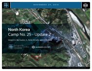
ASA_HRNK_Camp12_201608_v10_LR

Create successful ePaper yourself
Turn your PDF publications into a flip-book with our unique Google optimized e-Paper software.
H R<br />
N K<br />
CH’OMA-BONG KYO-HWA-SO NO. RESTRICTED 12, JŎNGŎ-RI AREA<br />
North Korea: Imagery Analysis of Kyo-hwa-so No. 12, Jŏngŏ-ri<br />
Satellite imagery more closely identifies<br />
the construction of the “Women’s<br />
Section” to the period between February<br />
and August 2009. This rectangular<br />
walled annex measures approximately<br />
46 meters by 128 meters (50 yards by 139<br />
yards) and encompasses approximately<br />
.6 hectares (7,000 square yards). Unlike<br />
the original prison compound, the<br />
“Women’s Section” does not have any<br />
visible garden plots.<br />
Former prisoners report that this<br />
Women’s Section has a division leader, a<br />
secretary, doctor, three female managers,<br />
and is “…divided into work units for tree<br />
and log cutting, agricultural production<br />
(beans, potatoes, and corn), livestock<br />
or animal husbandry, cooking (for the<br />
prisoners), which are the typical prison<br />
work units, plus a wig-making unit and<br />
an eyelash-making unit.” 14 These same<br />
reports contain detailed information<br />
concerning the internal layout of the<br />
women’s section and, while satellite<br />
imagery cannot determine the precision<br />
of these statements, the overall layout<br />
and dimensions provided very closely<br />
match the imagery. 15<br />
tion of the separate “Women’s Compound” during<br />
February-August 2009.<br />
14. Ibid. p. 17.<br />
15. KINU2016, pp. 81-82.<br />
In its present configuration, the expanded<br />
prison facility itself occupies a generally<br />
rectangular shaped area that measures<br />
approximately 188 meters by 128 meters<br />
(205 yards by 139 yards) and encompasses<br />
2.406 hectares (28,780 square<br />
yards). 16 It is surrounded by an approximately<br />
three-meter-high wall with two<br />
entrances (one for the main compound<br />
and one for the annex). There is no gate<br />
connecting the two compounds. Built into<br />
the wall are four elevated guard positions,<br />
one of which may have been abandoned<br />
as it no longer has a roof (Figure 15).<br />
Former detainees have reported different<br />
population figures over time for Kyohwa-so<br />
No. 12. For example, 1,300-1,500<br />
during 1998-1999, 1,700 during 2003-<br />
2006, and 5,000 (1,000 women and<br />
4,000 men) during 2008-2010. Although<br />
satellite imagery cannot confirm<br />
former detainee population estimates, the<br />
physical footprint of the prison suggests<br />
that if the more recent figures are even<br />
somewhat accurate, then the facility is<br />
overcrowded by most foreign standards.<br />
Areas 7-11, Mining Activity<br />
Satellite imagery collected from 2002<br />
through 2015 confirms former prisoner<br />
16. These measurements should be viewed as close<br />
approximations since the facility is not a rectangle<br />
with 90 o corners and they were derived from 50<br />
cm ground sample distance satellite imagery.<br />
reports about the presence of a copper<br />
mine in the valley south of Kyo-hwa-so<br />
No. 12 (Figure 16). This mining facility<br />
consists of four major components: a<br />
waste pond, mine processing buildings,<br />
mine and prisoner housing, and support<br />
buildings. 17 Former detainee Kim Won-gil<br />
identifies the mining activities to be the<br />
responsibility of prisoner Work Units 4, 5,<br />
and 6. 18<br />
At the entrance to the valley, 300 meters<br />
south of Kyo-hwa-so No. 12, is a waste<br />
pond covering 2.128 hectares (25,450<br />
square yards) for the mine processing<br />
facility. This pond is impounded by an<br />
earthen dam erected from mine waste.<br />
Raw waste is delivered to the pond via<br />
ditch and pipe. Here it settles and then<br />
is dredged out and used to reinforce the<br />
dam. Sitting on the dam is a drag-line<br />
excavator that dredges the pond and<br />
maintains the dam. Given the visible<br />
condition of the waste pond and dam<br />
and proximity to the nearby stream, it is<br />
17. At least one former detainee has reported that<br />
in addition to copper mining, Kyo-hwa-so No.<br />
12 was involved in the extraction of limestone.<br />
KINU2014, pp. 139-143. Another report states that<br />
the mine separates copper and gold out of the ore.<br />
2015 White Paper on North Korean Human Rights,<br />
(Seoul: Database Center for North Korean Human<br />
Rights, December 2015), p. 426.<br />
18. HG2, pp. 85-89. KINU2015, pp. 80-84 appears to<br />
provide a somewhat different description of the<br />
Work Units.<br />
likely that contaminants are present in<br />
the water downstream. This, in turn, raises<br />
the concern for possible health issues<br />
for persons living and working along the<br />
stream. On the south side of the waste<br />
pond is an approximately 4.3-meters-tall<br />
and 2-meters-wide structure that may be<br />
an abandoned guard tower or a smokestack<br />
from a razed structure.<br />
Approximately 570 meters south of the<br />
waste pond is a small ore processing<br />
facility consisting of a storage tank, four<br />
processing buildings, and eight support<br />
and housing structures (Figure 17). This<br />
facility was surrounded by a security<br />
fence and three guard positions from<br />
2003 to 2010 when the security fence<br />
was moved closer to the buildings.<br />
Between May and June 2015, it appears<br />
that the security fence may have been removed.<br />
Mine ore cars bring ore extracted<br />
from the nearby mine to the processing<br />
facility, where it is dumped, via a 370-meters-long<br />
electrified mine railway. Here<br />
the processing facility crushes the ore<br />
and produces copper products that are<br />
shipped out by truck (possibly to the rail<br />
station at P’ungsal-li, approximately 11 km<br />
to the north).<br />
Between July and September 2011, a<br />
road was built connecting the processing<br />
facility to a mine 1.2 kilometers to the<br />
northeast. This mine appears to have<br />
COPYRIGHT ©ALLSOURCE ANALYSIS, INC. 2016 14


![CV-MBM[186]](https://img.yumpu.com/59137292/1/190x238/cv-mbm186.jpg?quality=85)