ASA_HRNK_Camp12_201608_v10_LR

You also want an ePaper? Increase the reach of your titles
YUMPU automatically turns print PDFs into web optimized ePapers that Google loves.
H R<br />
N K<br />
CH’OMA-BONG KYO-HWA-SO NO. RESTRICTED 12, JŎNGŎ-RI AREA<br />
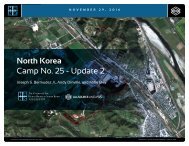
North Korea: Imagery Analysis of Kyo-hwa-so No. 12, Jŏngŏ-ri<br />
reports that the camp has added light<br />
industry and mining to its list of activities<br />
and that the original walled prison facility<br />
was expanded to its present size with the<br />
addition of an attached walled compound<br />
to handle an increased female population.<br />
Numerous small- and medium-sized<br />
cultivated fields, which were created by<br />
logging activities, are located throughout<br />
the area. Additionally, there are several<br />
small mining activities, most of which<br />
appear to have been abandoned.<br />
The camp appears to be connected to<br />
the regional electric power grid via buried<br />
high voltage power transmission cables<br />
that run from the town of Jŏn’gŏ-ri area<br />
to a substation at the camp’s mining<br />
facility. It is connected to the national<br />
rail network via the stations at Jŏn’gŏ-ri<br />
2.5 km southwest and P’ungsal-li 4.3 km<br />
north of the facility. With the exception of<br />
an unused grass airfield at Punyŏng, 21.5<br />
km south of the facility, the closest air<br />
facility is the Korean People’s Air Force<br />
Sŭngam-ni Air Base located 60 km to the<br />
south. This is a training base. Based on<br />
its mission, organization, and location, it<br />
almost certainly provides no support to<br />
Kyo-hwa-so No. 12.<br />
Imagery Analysis<br />
For analytical purposes, the camp is<br />
divided into 15 discrete locations or activities<br />
that provide insight into changes<br />
to the facility and its environs during the<br />
time period under study (Figure 3). 6<br />
Area 1, Security<br />
Since Kyo-hwa-so No. 12 is a small<br />
walled prison facility in a remote mountain<br />
valley, it does not have an extended<br />
patrolled security perimeter, as do North<br />
Korea’s kwan-li-so. 7 At least one former<br />
6. The following sources were used throughout this<br />
section: Hawk, David. The Hidden Gulag Second<br />
Edition, (Washington, D.C.: <strong>HRNK</strong>, 2003), pp. 85-89,<br />
107 and 227, (hereafter: HG2) available at http://<br />
www.hrnk.org/uploads/pdfs/ <strong>HRNK</strong>_HiddenGulag2_Web_5-18.pdf;<br />
HG4, pp. 12-27; KINU White<br />
Paper on Human Rights in North Korea 2014,<br />
(Seoul: Korea Institute for National Unification, July<br />
2014), pp. 139-143, (hereafter: KINU2014) available<br />
at www.kinu.or.kr/eng/pub/; KINU White Paper on<br />
Human Rights in North Korea 2015, (Seoul: Korea<br />
Institute for National Unification, September 2015),<br />
pp. 80-84, (hereafter: KINU2015) available at www.<br />
kinu.or.kr/eng/pub/; and Report of the Commission<br />
of Inquiry on Human Rights in the Democratic<br />
People’s Republic of Korea, A/HRC/25/CRP.1, (New<br />
York: UN Human Rights Council, 7 February 2014),<br />
pp. 65-66 and 199, available at http://www.ohchr.<br />
org/Documents/HRBodies/HRCouncil/CoIDPRK/<br />
Report/A.HRC.25.CRP.1_ENG.doc.<br />
detainee indicates that there are small<br />
remote guard positions on the ridges surrounding<br />
the valley in which Kyo-hwa-so<br />
No. 12 is located. 8 With the exception of<br />
one possible guard position that appears<br />
to have been present since 2003, none<br />
of these have been identified (Figure<br />
4). Several important activities, such as<br />
a mine processing facility and a mine<br />
portal and worker housing compound, do,<br />
however, have guard positions (Figure 5).<br />
There is a main entrance and checkpoint<br />
astride the only road leading into the<br />
valley. The walled prison facility occupies<br />
a generally rectangular-shaped area that<br />
measures approximately 188 meters by<br />
128 meters (205 yards by 139 yards) and<br />
encompasses 2.360 hectares (28,230<br />
square yards). It has approximately threemeter-high<br />
walls, four elevated guard<br />
positions, and two exterior entrances.<br />
Area 2, Main Entrance and Checkpoint<br />
The main facility entrance and checkpoint<br />
to the valley housing Kyo-hwa-so No.<br />
12 is located approximately 1.9 km to the<br />
northwest of the facility astride the only<br />
road leading to the area. In 2003, the<br />
entrance and checkpoint consisted of<br />
only a small building (Figure 6). By 2008,<br />
this had been expanded to three buildings<br />
including a checkpoint, barracks, and<br />
administration buildings. Between 2009<br />
and 2012, these buildings received new<br />
roofs (Figure 7).<br />
Area 3, Musal-li<br />
The village of Musal-li (Musan-dong) is<br />
located approximately 1.2 km southeast<br />
of the main facility entrance and<br />
checkpoint, astride a small stream that<br />
runs through it. The area consists of<br />
approximately 28 housing units and<br />
a small partially enclosed compound,<br />
accessed from a small bridge across the<br />
stream, on the north side of the stream.<br />
This compound is similar to those seen<br />
throughout North Korea that house small<br />
military, para-military, or security units,<br />
although a firm determination cannot be<br />
made at this time.<br />
There have been a small number of<br />
minor changes to the village between<br />
2003 and 2015 (Figure 8). For example,<br />
between February 2012 and February<br />
2013, three buildings were razed and the<br />
road through the village was improved.<br />
All such changes, however, are typical of<br />
what is seen in rural North Korea.<br />
7. HG2, pp. 85-89.<br />
8. HG2, pp. 85-89.<br />
COPYRIGHT ©ALLSOURCE ANALYSIS, INC. 2016 4
![CV-MBM[186]](https://img.yumpu.com/59137292/1/190x238/cv-mbm186.jpg?quality=85)