Ocean Thermal Resources and OTEC Site Selection Criteria
Ocean Thermal Resources and OTEC Site Selection Criteria
Ocean Thermal Resources and OTEC Site Selection Criteria

Create successful ePaper yourself
Turn your PDF publications into a flip-book with our unique Google optimized e-Paper software.
<strong>Ocean</strong> <strong>Thermal</strong> Resource <strong>and</strong> <strong>Site</strong> <strong>Selection</strong> <strong>Criteria</strong> (January 2011) luisvega@hawaii.edu<br />
oceanographic measurements. Monthly averages also are available. The data is provided<br />
with a resolution of one-quarter degree latitude by one-quarter degree longitude.<br />
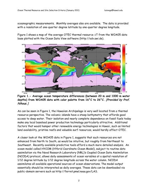
Figure 1 shows a map of the average <strong>OTEC</strong> thermal resource ∆T from the WOA05 data<br />
base plotted with the <strong>Ocean</strong> Data View software (http://odv.awi.de).<br />
Figure 1.- Average ocean temperature differences (between 20 m <strong>and</strong> 1000 m water<br />
depths) from WOA05 data with color palette from 16°C to 26°C. [Provided by Prof.<br />
Nihous. ]<br />
As can be seen in Figure 1, the Hawaiian Archipelago is very well located from a thermal<br />
resource perspective. The volcanic isl<strong>and</strong>s have a steep bathymetry that affords good<br />
access to deep water. Their isolation <strong>and</strong> nearly complete dependence on fossil fuels today<br />
make any local baseload power production technology particularly attractive. Additional<br />
factors that would hamper other renewable energy technologies in Hawaii, such as limited<br />
l<strong>and</strong> availability, pristine reefs <strong>and</strong> valuable surf resources, would hardly affect <strong>OTEC</strong>.<br />
A closer look at the WOA05 data in Figure 1, suggests that such resources are not<br />
enhanced from North to South, as would be intuitive, but roughly from Northeast to<br />
Southwest. Recently available predictive tools afford a much more detailed analysis. An<br />
ocean model called HYCOM (HYbrid Coordinate <strong>Ocean</strong> Model), subject to routine data<br />
assimilation via the Naval Research Laboratory (NRL)’s Coupled <strong>Ocean</strong> Data Assimilation<br />
(NCODA) protocol, allows daily assessments of ocean variables at a spatial resolution of<br />
1/12 degree latitude by 1/12 degree longitude across the water column. NCODA<br />
assimilates all available operational sources of ocean observations. The model output<br />
essentially should be interpreted as daily averages. These data can be downloaded via<br />
public-domain servers such as http://ferret.pmel.noaa.gov/LAS.<br />
2