Ocean Thermal Resources and OTEC Site Selection Criteria
Ocean Thermal Resources and OTEC Site Selection Criteria
Ocean Thermal Resources and OTEC Site Selection Criteria

You also want an ePaper? Increase the reach of your titles
YUMPU automatically turns print PDFs into web optimized ePapers that Google loves.
<strong>Ocean</strong> <strong>Thermal</strong> Resource <strong>and</strong> <strong>Site</strong> <strong>Selection</strong> <strong>Criteria</strong> (January 2011) luisvega@hawaii.edu<br />
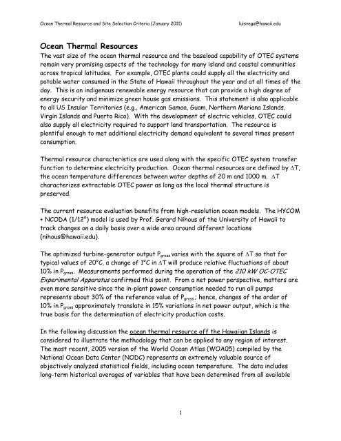
<strong>Ocean</strong> <strong>Thermal</strong> <strong>Resources</strong><br />
The vast size of the ocean thermal resource <strong>and</strong> the baseload capability of <strong>OTEC</strong> systems<br />
remain very promising aspects of the technology for many isl<strong>and</strong> <strong>and</strong> coastal communities<br />
across tropical latitudes. For example, <strong>OTEC</strong> plants could supply all the electricity <strong>and</strong><br />
potable water consumed in the State of Hawaii throughout the year <strong>and</strong> at all times of the<br />
day. This is an indigenous renewable energy resource that can provide a high degree of<br />
energy security <strong>and</strong> minimize green house gas emissions. This statement is also applicable<br />
to all US Insular Territories (e.g., American Samoa, Guam, Northern Mariana Isl<strong>and</strong>s,<br />
Virgin Isl<strong>and</strong>s <strong>and</strong> Puerto Rico). With the development of electric vehicles, <strong>OTEC</strong> could<br />
also supply all electricity required to support l<strong>and</strong> transportation. The resource is<br />
plentiful enough to met additional electricity dem<strong>and</strong> equivalent to several times present<br />
consumption.<br />
<strong>Thermal</strong> resource characteristics are used along with the specific <strong>OTEC</strong> system transfer<br />
function to determine electricity production. <strong>Ocean</strong> thermal resources are defined by ∆T,<br />
the ocean temperature differences between water depths of 20 m <strong>and</strong> 1000 m. ∆T<br />
characterizes extractable <strong>OTEC</strong> power as long as the local thermal structure is<br />
preserved.<br />
The current resource evaluation benefits from high-resolution ocean models. The HYCOM<br />
+ NCODA (1/12°) model is used by Prof. Gerard Nihous of the University of Hawaii to<br />
track changes on a daily basis over a wide area around different locations<br />
(nihous@hawaii.edu).<br />
The optimized turbine-generator output Pgross varies with the square of ∆T so that for<br />
typical values of 20°C, a change of 1°C in ∆T will produce relative fluctuations of about<br />
10% in Pgross. Measurements performed during the operation of the 210 kW OC-<strong>OTEC</strong><br />
Experimental Apparatus confirmed this point. From a net power perspective, matters are<br />
even more sensitive since the in-plant power consumption needed to run all pumps<br />
represents about 30% of the reference value of Pgross ; hence, changes of the order of<br />
10% in Pgross approximately translate in 15% variations in net power output, which is the<br />
true basis for the determination of electricity production costs.<br />
In the following discussion the ocean thermal resource off the Hawaiian Isl<strong>and</strong>s is<br />
considered to illustrate the methodology that can be applied to any region of interest.<br />
The most recent, 2005 version of the World <strong>Ocean</strong> Atlas (WOA05) compiled by the<br />
National <strong>Ocean</strong> Data Center (NODC) represents an extremely valuable source of<br />
objectively analyzed statistical fields, including ocean temperature. The data includes<br />
long-term historical averages of variables that have been determined from all available<br />
1
<strong>Ocean</strong> <strong>Thermal</strong> Resource <strong>and</strong> <strong>Site</strong> <strong>Selection</strong> <strong>Criteria</strong> (January 2011) luisvega@hawaii.edu<br />
oceanographic measurements. Monthly averages also are available. The data is provided<br />
with a resolution of one-quarter degree latitude by one-quarter degree longitude.<br />
Figure 1 shows a map of the average <strong>OTEC</strong> thermal resource ∆T from the WOA05 data<br />
base plotted with the <strong>Ocean</strong> Data View software (http://odv.awi.de).<br />
Figure 1.- Average ocean temperature differences (between 20 m <strong>and</strong> 1000 m water<br />
depths) from WOA05 data with color palette from 16°C to 26°C. [Provided by Prof.<br />
Nihous. ]<br />
As can be seen in Figure 1, the Hawaiian Archipelago is very well located from a thermal<br />
resource perspective. The volcanic isl<strong>and</strong>s have a steep bathymetry that affords good<br />
access to deep water. Their isolation <strong>and</strong> nearly complete dependence on fossil fuels today<br />
make any local baseload power production technology particularly attractive. Additional<br />
factors that would hamper other renewable energy technologies in Hawaii, such as limited<br />
l<strong>and</strong> availability, pristine reefs <strong>and</strong> valuable surf resources, would hardly affect <strong>OTEC</strong>.<br />
A closer look at the WOA05 data in Figure 1, suggests that such resources are not<br />
enhanced from North to South, as would be intuitive, but roughly from Northeast to<br />
Southwest. Recently available predictive tools afford a much more detailed analysis. An<br />
ocean model called HYCOM (HYbrid Coordinate <strong>Ocean</strong> Model), subject to routine data<br />
assimilation via the Naval Research Laboratory (NRL)’s Coupled <strong>Ocean</strong> Data Assimilation<br />
(NCODA) protocol, allows daily assessments of ocean variables at a spatial resolution of<br />
1/12 degree latitude by 1/12 degree longitude across the water column. NCODA<br />
assimilates all available operational sources of ocean observations. The model output<br />
essentially should be interpreted as daily averages. These data can be downloaded via<br />
public-domain servers such as http://ferret.pmel.noaa.gov/LAS.<br />
2
<strong>Ocean</strong> <strong>Thermal</strong> Resource <strong>and</strong> <strong>Site</strong> <strong>Selection</strong> <strong>Criteria</strong> (January 2011) luisvega@hawaii.edu<br />
Figure 2 shows the average available <strong>OTEC</strong> thermal resource ∆T over a period of three<br />
years, from July 1, 2007 through June 30, 2010. Areas that are shallower than 1000 m<br />
are displayed in white to indicate that ∆T is not defined there. Although overall<br />
geographic variations in the selected area covering 7 degrees of latitude <strong>and</strong> 9 degrees of<br />
longitude are within 2°C, a prominent wedge can be seen; its apex roughly lies at the<br />
eastern tip of the Big Isl<strong>and</strong>, <strong>and</strong> the feature is somewhat symmetric across the latitude<br />
of that point; from the apex, a line running along the northeast (windward) coasts of the<br />
isl<strong>and</strong>s defines the angular overture of the wedge. The emergence of such a feature is<br />
likely to be the result of the strong influence the isl<strong>and</strong>s exert on large-scale ocean<br />
currents. The westward flowing North Equatorial Current (NEC) forks at the Big Isl<strong>and</strong><br />
<strong>and</strong> gives rise to a branch that follows a northwesterly direction (North Hawaiian Ridge<br />
Current). West of the isl<strong>and</strong>s, the vorticity of the wind-stress curl associated with the<br />
wake of the isl<strong>and</strong>s causes a clockwise circulation centered at 19°N <strong>and</strong> a counterclockwise<br />
circulation centered at 20°30'N, with the narrow Hawaiian Lee Counter Current<br />
(HLCC) extending between them from 170°W (or from as far as the Dateline) to 158°W.<br />
The eastward flowing HLCC is responsible for the advection of warm water toward the lee<br />
of the Hawaiian archipelago.<br />
Figure 2.- Average ocean temperature differences (between 20 m <strong>and</strong> 1000 m water<br />
depths) around the main Hawaiian Isl<strong>and</strong>s from HYCOM + NCODA (1/12°) data for<br />
the period July 1, 2007 through June 30, 2010. [Provided by Prof. Nihous. ]<br />
3
<strong>Ocean</strong> <strong>Thermal</strong> Resource <strong>and</strong> <strong>Site</strong> <strong>Selection</strong> <strong>Criteria</strong> (January 2011) luisvega@hawaii.edu<br />
<strong>Site</strong> <strong>Selection</strong> <strong>Criteria</strong> for <strong>OTEC</strong> Plants<br />
As stated above, the search for renewable energy resources has resulted in <strong>OTEC</strong>’s<br />
second revival. As it is well know the concept utilizes the differences in temperature, ∆T,<br />
between the warm tropical surface waters, <strong>and</strong> the cold deep ocean waters available at<br />
depths of about 1000 m, as the source of the thermal energy required.<br />
The historical monthly averages of ∆T for February <strong>and</strong> August are depicted in Figures 3<br />
<strong>and</strong> 4 respectively. Values are color coded as indicated in the right-h<strong>and</strong>-side of the<br />
Figures. The values were obtained by Prof. Nihous from the National <strong>Ocean</strong> Data Center’s<br />
World <strong>Ocean</strong> Atlas. Deep seawater flows from the Polar Regions. These polar water,<br />
which represents up to 60% of all seawater, originates mainly from the Arctic for the<br />
Atlantic <strong>and</strong> North Pacific <strong>Ocean</strong>s, <strong>and</strong> from the Antarctic (Weddell Sea) for all other<br />
major oceans. Therefore, Tcw at a given depth, approximately below 500 m, does not vary<br />
much throughout all regions of interest for <strong>OTEC</strong>. It is also a weak function of depth,<br />
with a typical gradient of 1°C per 150 m between 500 m <strong>and</strong> 1000 m. These considerations<br />
may lead to regard Tcw as nearly constant, with a value of 4°C to 5°C at 1000 m.<br />
A desirable <strong>OTEC</strong> thermal resource of about 20°C requires typical values of Tww of the<br />
order of 25°C. Globally speaking, regions between latitudes 20°N <strong>and</strong> 20°S are adequate.<br />
Some definite exceptions exist due to strong cold currents: along the West Coast of<br />
South America <strong>and</strong> to a lesser extent for the West Coast of Southern Africa. Moreover,<br />
Tww varies throughout the year, <strong>and</strong> sometimes exhibits a significant seasonal drop due to<br />
the upwelling of deeper water induced by the action of the wind: such are the cases of<br />
the West Coast of Northern Africa in the southern hemisphere winter (Figure 4).<br />
The following summarizes the availability of the <strong>OTEC</strong> thermal resource throughout the<br />
World:<br />
• Equatorial waters, defined as lying between 10°N <strong>and</strong> 10°S are adequate except for<br />
the West Coasts of South America <strong>and</strong> Southern Africa;<br />
• Tropical waters, defined as extending from the equatorial region boundary to,<br />
respectively, 20°N <strong>and</strong> 20°S, are adequate, except for the West Coasts of South<br />
America <strong>and</strong> of Southern Africa; moreover, seasonal upwelling phenomena would<br />
require significant temperature enhancement for the West Coast of Northern<br />
Africa, the Horn of Africa, <strong>and</strong> off the Arabian Peninsula.<br />
4
<strong>Ocean</strong> <strong>Thermal</strong> Resource <strong>and</strong> <strong>Site</strong> <strong>Selection</strong> <strong>Criteria</strong> (January 2011) luisvega@hawaii.edu<br />
The accessibility of deep cold seawater represents the most important physical criterion<br />
for <strong>OTEC</strong> site selection, once the existence of an adequate thermal resource has been<br />
established. In the case of a floating plant, the issue of cold seawater accessibility is only<br />
relevant inasmuch as submarine power cables, <strong>and</strong>, maybe, a desalinated water hose, are<br />
needed to transfer the <strong>OTEC</strong> products to shore. For the grazing plantship, with energy<br />
intensive products like hydrogen or ammonia as the product, the distance is important<br />
from the perspective of the transit time for the vessels that would transport the product<br />
to shore.<br />
Many other points must be considered when evaluating potential <strong>OTEC</strong> sites, from<br />
logistics to socioeconomic <strong>and</strong> political factors. One argument in favor of <strong>OTEC</strong> lies in its<br />
renewable character: it may be seen as a means to provide remote <strong>and</strong> isolated<br />
communities with some degree of energy independence, <strong>and</strong> to offer them a potential for<br />
safe economic development. Such operational advantages, however, are often accompanied<br />
by serious logistical problems during the plant construction <strong>and</strong> installation phases: if an<br />
isl<strong>and</strong> is under development, it is likely to lack the infrastructure desirable for this type<br />
of project, including harbors, airports, good roads <strong>and</strong> communication systems. Moreover,<br />
the population base should be compatible with the <strong>OTEC</strong> plant size: adequate manpower<br />
must be supplied to operate the plant; <strong>and</strong>, the electricity <strong>and</strong> fresh water plant outputs<br />
should match local consumption in orders of magnitude.<br />
Another important point to consider is the preservation of the environment in the area of<br />
the selected site, inasmuch as preservation of the environment anywhere is bound to have<br />
positive effects elsewhere. <strong>OTEC</strong> is one of the most benign power production technology,<br />
since the h<strong>and</strong>ling of hazardous substances is limited to the working fluid (e.g.: ammonia),<br />
<strong>and</strong> no noxious by-products are generated; <strong>OTEC</strong> merely requires the pumping <strong>and</strong> return<br />
of various seawater masses, which, according to preliminary studies, can be accomplished<br />
with virtually no adverse impact. This argument should be very attractive, for pristine<br />
isl<strong>and</strong> ecosystems, as well as for already polluted <strong>and</strong> overburdened environments. For<br />
example, the amount of CO2 released from electricity-producing plants (expressed in gr<br />
of CO2 per kWh) ranges from 1000, for coal fired plants, to 700, for fuel-oil plants, while<br />
for OC-<strong>OTEC</strong> plants it is at most ∼ 1 % of the amount released by fuel oil plants. The<br />
value is much lower in the case of a CC-<strong>OTEC</strong> plant.<br />
Ninety-eight nations <strong>and</strong> territories with access to the <strong>OTEC</strong> thermal resource within<br />
their 200 nautical mile exclusive economic zone (EEZ) were identified in the 1980’s. A<br />
partial list is provided in Table 1. For the majority of these locations, the <strong>OTEC</strong> resource<br />
is applicable only to floating plants. Unfortunately, now as then, there is no <strong>OTEC</strong> plant<br />
with an operational record available. This still remains the impediment to <strong>OTEC</strong><br />
commercialization.<br />
5
<strong>Ocean</strong> <strong>Thermal</strong> Resource <strong>and</strong> <strong>Site</strong> <strong>Selection</strong> <strong>Criteria</strong> (January 2011) luisvega@hawaii.edu<br />
Figure 3.- Historical Monthly average of ∆T during February from WOA05.<br />
Figure 4.- Historical Monthly average of ∆T during August from WOA05.<br />
6
<strong>Ocean</strong> <strong>Thermal</strong> Resource <strong>and</strong> <strong>Site</strong> <strong>Selection</strong> <strong>Criteria</strong> (January 2011) luisvega@hawaii.edu<br />
GEOGRAPHICAL<br />
AREA MAINLAND ISLAND<br />
__________________________________________________________________________<br />
AMERICAS Mexico Guyana Cuba Guadeloupe<br />
Brazil Suriname Haiti Martinique<br />
Colombia French Guiana Dominican Rep. Barbados<br />
Costa Rica Nicaragua Jamaica Dominica<br />
Guatemala El Salvador Virgin Is. St. Lucia<br />
Honduras Belize Grenada St. Kitts<br />
Panama United States St. Vincent Barbuda<br />
Venezuela Gr<strong>and</strong> Cayman Montserrat<br />
Antigua The Grenadines<br />
Puerto Rico Curacao<br />
Trinidad & Tobago Aruba<br />
Bahamas<br />
__________________________________________________________________________<br />
AFRICA Nigeria Gabon Sao Tome & Principe<br />
Ghana Benin Ascension<br />
Ivory Coast Zaire Comoros<br />
Kenya Angola Aldabra<br />
Tanzania Cameroon Madagascar<br />
Congo Mozambique<br />
Guinea Eq. Guinea<br />
Sierra Leone Togo<br />
Liberia Somalia<br />
__________________________________________________________________________<br />
INDIAN/PACIFIC<br />
OCEAN India Australia Indonesia American Samoa<br />
Burma Japan Philippines Northern Marianas<br />
China Thail<strong>and</strong> Sri Lanka Guam<br />
Vietnam Hong Kong Papua New Guinea Kiribati<br />
Bangladesh Brunei Taiwan French Polynesia<br />
Malaysia Fiji New Caledonia<br />
Nauru Diego Garcia<br />
Seychelles Tuvalu<br />
Maldives Wake Is.<br />
Vanuatu Solomon Is.<br />
Samoa Mauritius<br />
Tonga Okinawa<br />
Cook Is. Hawaii<br />
Wallis & Futuna Is.<br />
Table 1.- List of Nations with Appropriate <strong>Ocean</strong> <strong>Thermal</strong> Resource within their 200<br />
nautical miles Exclusive Economic Zone.<br />
7