Welsh Country March-April 2017

Create successful ePaper yourself
Turn your PDF publications into a flip-book with our unique Google optimized e-Paper software.
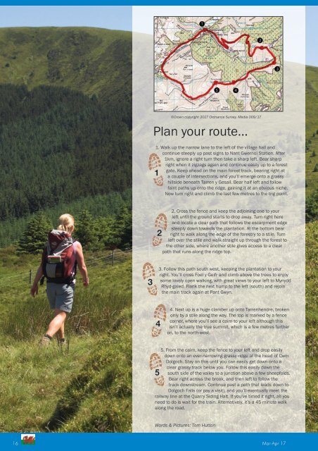
©Crown copyright <strong>2017</strong> Ordnance Survey. Media 009/17<br />
Plan your route...<br />
1. Walk up the narrow lane to the left of the village hall and<br />
continue steeply up past signs to Nant Gwernol Station. After<br />
1km, ignore a right turn then take a sharp left. Bear sharp<br />
right when it zigzags again and continue easily up to a forest<br />
gate. Keep ahead on the main forest track, bearing right at<br />
a couple of intersections, and you’ll emerge onto a grassy<br />
hillside beneath Tarren y Gesail. Bear half left and follow<br />
faint paths up onto the ridge, gaining it at an obvious niche.<br />
Now turn right and climb the last few metres to the trig point.<br />
2. Cross the fence and keep the adjoining one to your<br />
left until the ground starts to drop away. Turn right here<br />
and locate a clear path that follows the escarpment edge<br />
steeply down towards the plantation. At the bottom bear<br />
right to walk along the edge of the forestry to a stile. Turn<br />
left over the stile and walk straight up through the forest to<br />
the other side, where another stile gives access to a clear<br />
path that runs along the ridge top.<br />
3. Follow this path south west, keeping the plantation to your<br />
right. You’ll cross Foel y Geifr and climb above the trees to enjoy<br />
some lovely open walking, with great views to your left to Mynydd<br />
Rhyd-galed. Flank the next hump to the left (south) and rejoin<br />
the main track again at Pant Gwyn.<br />
4. Next up is a huge clamber up onto Tarrenhendre, broken<br />
only by a stile along the way. The top is marked by a fence<br />
corner, where you’ll see a cairn to your left although this<br />
isn’t actually the true summit, which is a few metres further<br />
on, to the north-west.<br />
5. From the cairn, keep the fence to your left and drop easily<br />
down onto an ever-narrowing grassy ridge at the head of Cwm<br />
Dolgoch. Stay on this until you can easily get down onto a<br />
clear grassy track below you. Follow this easily down the<br />
south side of the valley to a junction above a few sheepfolds.<br />
Bear right across the brook, and then left to follow the<br />
track downstream. Continue past a path that leads down to<br />
Dolgoch Falls (or pay a visit), and you’ll eventually meet the<br />
railway line at the Quarry Siding Halt. If you’ve timed it right, all you<br />
need to do is wait for the train. Alternatively, it’s a 45 minute walk<br />
along the road.<br />
Words & Pictures: Tom Hutton<br />
16 Mar-Apr17