Microsoft PowerPoint - 100 Page Rancocas Creek Water Trail Guide

You also want an ePaper? Increase the reach of your titles
YUMPU automatically turns print PDFs into web optimized ePapers that Google loves.
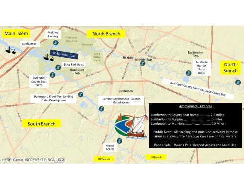
Main<br />
Stem<br />
Melpine<br />
Landing<br />
North Branch<br />
Confluence<br />
Burlington<br />
County Boat<br />
Ramp<br />
State Park Ramp<br />
Smithville<br />
Burl Co<br />
Parks<br />
Hdqrs<br />
North<br />
Branch<br />
Hainesport <strong>Creek</strong> Turn Landing<br />
Under Development<br />
South Branch<br />
Lumberton Municipal<br />
Gated Access<br />
Gated<br />
Access<br />
Launch<br />
Approximate Distances<br />
Lumberton to County Boat Ramp............. 2.5 miles<br />
Lumberton to Melpine.............................. 6 miles<br />
Lumberton to Mt. Holly.............................. 10 Miles<br />
Paddle<br />
Note: All paddling and multi-<br />
use activities in these<br />
areas as above of the <strong>Rancocas</strong> <strong>Creek</strong> are on tidal waters.<br />
Paddle<br />
Safe. Wear a PFD. Respect Access and Multi-U se.<br />
SW Branch<br />
S Branch