

InTownsville and Magnetic Island Guide September 2019 to February 2020
A free guide to the area of Townsville, Magnetic Island and surrounding areas in Tropical North Queensland, Australia
A free guide to the area of Townsville, Magnetic Island and surrounding areas in Tropical North Queensland, Australia

Create successful ePaper yourself
Turn your PDF publications into a flip-book with our unique Google optimized e-Paper software.
ENNEDY ST<br />
Queens<br />
Park<br />
Queens<br />
Gardens<br />
STANLEY ST<br />
STANTON TCE<br />
WILLS ST<br />
GREGORY ST<br />
MURRAY ST<br />
QUEEN ST<br />
HILL<br />
SIDE CR<br />
VICTORIA ST<br />
Reservoir<br />
WALKER ST<br />
JONES ST<br />
HALE ST<br />
BLACKWOOD ST<br />
WILLS ST<br />
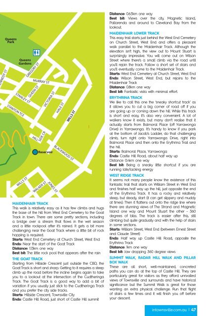
MAIDENHAIR TRACK<br />
This walk is relatively easy as it has few climbs <strong>and</strong> hugs<br />
the base of the hill from West End Cemetery <strong>to</strong> the Goat<br />
Track in <strong>to</strong>wn. There are some pretty sections, including<br />
a bridge over a stream that flows in the wet season<br />
<strong>and</strong> a little rockpool after it’s rained. It gets a bit more<br />
challenging near the Goat Track where a little bit of rock<br />
hopping is required.<br />
Starts: West End Cemetery at Church Street, West End<br />
Ends: Near the start of the Goat Track<br />
Distance: 1.13km one way<br />
Best bit: The little rock pool that appears after the rain<br />
THE GOAT TRACK<br />
Starting from Hillside Crescent just outside the CBD, the<br />
Goat Track is short <strong>and</strong> sharp. Getting <strong>to</strong> it requires a steep<br />
climb up the road before the incline begins again <strong>to</strong> take<br />
you <strong>to</strong> a lookout at the intersection of the Cudtheringa<br />
Track. The Goat Track is a good way <strong>to</strong> add a bit of<br />
variation if you usually just stick <strong>to</strong> the Cudtheringa Track<br />
<strong>and</strong> you prefer the city side tracks.<br />
Starts: Hillside Crescent, Townsville City<br />
Ends: Castle Hill Road, just short of Castle Hill summit<br />
Distance: 0.63km one way<br />
Best bit: Views over the city, <strong>Magnetic</strong> Isl<strong>and</strong>,<br />
Pallarenda <strong>and</strong> around <strong>to</strong> Clevel<strong>and</strong> Bay from the<br />
lookout.<br />
MAIDENHAIR LOWER TRACK<br />
This easy trail starts just behind the West End Cemetery<br />
on Church Street, West End <strong>and</strong> offers a pleasant<br />
walk parallel <strong>to</strong> the Maidenhair Track. Although the<br />
elevation isn’t high, the view out <strong>to</strong> Mount Stuart is<br />
surprisingly impressive. You will come out on Wilson<br />
Street where there’s a small climb via the road until<br />
you’ll rejoin the track. Follow a short set of stairs <strong>and</strong><br />
you’ll eventually come <strong>to</strong> the Maidenhair Track.<br />
Starts: West End Cemetery at Church Street, West End<br />
Ends: Wilson Street, West End, but rejoins <strong>to</strong> the<br />
Maidenhair Track<br />
Distance: 0.8km one way<br />
Best bit: Fantastic vista with minimal effort.<br />
ERYTHRINA TRACK<br />
We like <strong>to</strong> call this one the ‘sneaky shortcut track’ as<br />
it allows you <strong>to</strong> cut a big corner of road off if you<br />
are going up or coming down the hill. While this track<br />
is short <strong>and</strong> easy, it’s also very convenient. A lot of<br />
walkers know it exists, but many don’t realise that it<br />
actually starts from Balmoral Place (off Yarrawonga<br />
Drive) in Yarrawonga. It’s h<strong>and</strong>y <strong>to</strong> know if you park<br />
at the bot<strong>to</strong>m of Jacob’s Ladder, do that challenging<br />
climb, turn right on<strong>to</strong> Yarrawonga Drive, right in<strong>to</strong><br />
Balmoral Place <strong>and</strong> then on<strong>to</strong> the Erythrina Trail <strong>and</strong><br />
the hill.<br />
Starts: Balmoral Place, Yarrawonga<br />
Ends: Castle Hill Road, about half way up<br />
Distance: 0.4km one way<br />
Best bit: Being a sneaky little shortcut if you are<br />
running late/lacking energy<br />
WEST RIDGE TRACK<br />
It seems not many people know the existence of this<br />
fantastic trail that starts on William Street in West End<br />
<strong>and</strong> finishes half way up the hill, just opposite the end<br />
of the Erythrina Track. It has a rocky <strong>and</strong> relatively<br />
steep, but steady, start (it can get slippery <strong>and</strong> muddy<br />
at times). Then it flattens out on<strong>to</strong> the ridge line where<br />
there are stunning views of The Str<strong>and</strong> <strong>and</strong> <strong>Magnetic</strong><br />
Isl<strong>and</strong> one way <strong>and</strong> Mount Stuart the other - 360<br />
degrees of bliss. The track is easier after this, still<br />
climbing but quite gradually <strong>and</strong> with the help of stairs<br />
in some sections.<br />
Starts: William Street, West End (between Ernest Street<br />
<strong>and</strong> Claude Street)<br />
Ends: Half way up Castle Hill Road, opposite the<br />
Erythrina Track<br />
Distance: 1km one way<br />
Best bit: Jaw dropping 360 degree views<br />
SUMMIT WALK, RADAR HILL WALK AND PILLAR<br />
BOX WALK<br />
These are all short, well-maintained, concreted<br />
paths you can do at the <strong>to</strong>p of Castle Hill. They are<br />
particularly great for visi<strong>to</strong>rs as they afford unrivalled<br />
views of Townsville <strong>and</strong> surrounds <strong>and</strong> have his<strong>to</strong>rical<br />
significance but the Summit Walk is great for those<br />
wanting an extra physical challenge. Run that flight<br />
of stairs a few times <strong>and</strong> it will finish you off before<br />
your descent.<br />
in<strong>to</strong>wnsville.com.au | 47
