

InTownsville and Magnetic Island Guide September 2019 to February 2020
A free guide to the area of Townsville, Magnetic Island and surrounding areas in Tropical North Queensland, Australia
A free guide to the area of Townsville, Magnetic Island and surrounding areas in Tropical North Queensland, Australia

Create successful ePaper yourself
Turn your PDF publications into a flip-book with our unique Google optimized e-Paper software.
ISLAND WALKS<br />
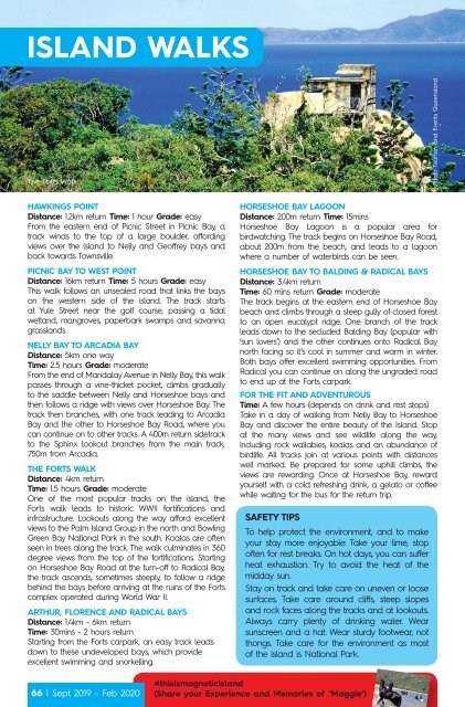
The Forts Walk<br />
Pho<strong>to</strong> Tourism <strong>and</strong> Events Queensl<strong>and</strong><br />
HAWKINGS POINT<br />
Distance: 1.2km return Time: 1 hour Grade: easy<br />
From the eastern end of Picnic Street in Picnic Bay, a<br />
track winds <strong>to</strong> the <strong>to</strong>p of a large boulder, affording<br />
views over the isl<strong>and</strong> <strong>to</strong> Nelly <strong>and</strong> Geoffrey bays <strong>and</strong><br />
back <strong>to</strong>wards Townsville.<br />
PICNIC BAY TO WEST POINT<br />
Distance: 16km return Time: 5 hours Grade: easy<br />
This walk follows an unsealed road that links the bays<br />
on the western side of the isl<strong>and</strong>. The track starts<br />
at Yule Street near the golf course, passing a tidal<br />
wetl<strong>and</strong>, mangroves, paperbark swamps <strong>and</strong> savanna<br />
grassl<strong>and</strong>s.<br />
NELLY BAY TO ARCADIA BAY<br />
Distance: 5km one way<br />
Time: 2.5 hours Grade: moderate<br />
From the end of M<strong>and</strong>alay Avenue in Nelly Bay, this walk<br />
passes through a vine-thicket pocket, climbs gradually<br />
<strong>to</strong> the saddle between Nelly <strong>and</strong> Horseshoe bays <strong>and</strong><br />
then follows a ridge with views over Horseshoe Bay. The<br />
track then branches, with one track leading <strong>to</strong> Arcadia<br />
Bay <strong>and</strong> the other <strong>to</strong> Horseshoe Bay Road, where you<br />
can continue on <strong>to</strong> other tracks. A 400m return sidetrack<br />
<strong>to</strong> the Sphinx lookout branches from the main track,<br />
750m from Arcadia.<br />
THE FORTS WALK<br />
Distance: 4km return<br />
Time: 1.5 hours Grade: moderate<br />
One of the most popular tracks on the isl<strong>and</strong>, the<br />
Forts walk leads <strong>to</strong> his<strong>to</strong>ric WWII fortifications <strong>and</strong><br />
infrastructure. Lookouts along the way afford excellent<br />
views <strong>to</strong> the Palm Isl<strong>and</strong> Group in the north <strong>and</strong> Bowling<br />
Green Bay National Park in the south. Koalas are often<br />
seen in trees along the track. The walk culminates in 360<br />
degree views from the <strong>to</strong>p of the fortifications. Starting<br />
on Horseshoe Bay Road at the turn-off <strong>to</strong> Radical Bay,<br />
the track ascends, sometimes steeply, <strong>to</strong> follow a ridge<br />
behind the bays before arriving at the ruins of the Forts<br />
complex operated during World War II.<br />
ARTHUR, FLORENCE AND RADICAL BAYS<br />
Distance: 1.4km - 6km return<br />
Time: 30mins - 2 hours return<br />
Starting from the Forts carpark, an easy track leads<br />
down <strong>to</strong> these undeveloped bays, which provide<br />
excellent swimming <strong>and</strong> snorkelling.<br />
HORSESHOE BAY LAGOON<br />
Distance: 200m return Time: 15mins<br />
Horseshoe Bay Lagoon is a popular area for<br />
birdwatching. The track begins on Horseshoe Bay Road,<br />
about 200m from the beach, <strong>and</strong> leads <strong>to</strong> a lagoon<br />
where a number of waterbirds can be seen.<br />
HORSESHOE BAY TO BALDING & RADICAL BAYS<br />
Distance: 3.4km return<br />
Time: 60 mins return Grade: moderate<br />
The track begins at the eastern end of Horseshoe Bay<br />
beach <strong>and</strong> climbs through a steep gully of closed forest<br />
<strong>to</strong> an open eucalypt ridge. One branch of the track<br />
leads down <strong>to</strong> the secluded Balding Bay (popular with<br />
‘sun lovers’) <strong>and</strong> the other continues on<strong>to</strong> Radical Bay<br />
north facing so it’s cool in summer <strong>and</strong> warm in winter.<br />
Both bays offer excellent swimming opportunities. From<br />
Radical you can continue on along the ungraded road<br />
<strong>to</strong> end up at the Forts carpark.<br />
FOR THE FIT AND ADVENTUROUS<br />
Time: A few hours (depends on drink <strong>and</strong> rest s<strong>to</strong>ps)<br />
Take in a day of walking from Nelly Bay <strong>to</strong> Horseshoe<br />
Bay <strong>and</strong> discover the entire beauty of the Isl<strong>and</strong>. S<strong>to</strong>p<br />
at the many views <strong>and</strong> see wildlife along the way,<br />
including rock wallabies, koalas <strong>and</strong> an abundance of<br />
birdlife. All tracks join at various points with distances<br />
well marked. Be prepared for some uphill climbs, the<br />
views are rewarding. Once at Horseshoe Bay, reward<br />
yourself with a cold refreshing drink, a gela<strong>to</strong> or coffee<br />
while waiting for the bus for the return trip.<br />
SAFETY TIPS<br />
To help protect the environment, <strong>and</strong> <strong>to</strong> make<br />
your stay more enjoyable: Take your time, s<strong>to</strong>p<br />
often for rest breaks. On hot days, you can suffer<br />
heat exhaustion. Try <strong>to</strong> avoid the heat of the<br />
midday sun.<br />
Stay on track <strong>and</strong> take care on uneven or loose<br />
surfaces. Take care around cliffs, steep slopes<br />
<strong>and</strong> rock faces along the tracks <strong>and</strong> at lookouts.<br />
Always carry plenty of drinking water. Wear<br />
sunscreen <strong>and</strong> a hat. Wear sturdy footwear, not<br />
thongs. Take care for the environment as most<br />
of the isl<strong>and</strong> is National Park.<br />
66 | Sept <strong>2019</strong> - Feb <strong>2020</strong><br />
#thisismagneticisl<strong>and</strong><br />
(Share your Experience <strong>and</strong> Memories of ‘Maggie’)
