Mar_Apr_PCC_2017_Web

Create successful ePaper yourself
Turn your PDF publications into a flip-book with our unique Google optimized e-Paper software.
Terry Brase<br />
Educational Consultant, Former<br />
Precision Agriculture Educator and<br />
Author<br />
Twenty years ago it was hard to convince<br />
some west coast growers that<br />
RTK was necessary. After all, that was<br />
just something that was used by those<br />
large Midwest growers that had thousand<br />
acre fields to manage. But the<br />
whole concept of RTK is high accuracy<br />
(possibly sub-inch) and precision; that<br />
applies to large and small fields alike.<br />
At West Hills College, the Farm of<br />
the Future was designed and built to<br />
serve as a practical learning farm for<br />
students but also to serve the agricultural<br />
community as a model demonstrating<br />
emerging technologies and<br />
how they could be applied to farms<br />
in the Central Valley. To do this and<br />
as part of the precision ag classes, we<br />
provide examples of RTK GPS.<br />
RTK stands for Real Time Kinematic<br />
and is a type of correction for<br />
GPS. The name comes from surveying<br />
and refers to its ability to maintain the<br />
calculation of a high accuracy position<br />
while on the move. Previously a surveyor<br />
would have to be in one position<br />
for an extended length of time to get a<br />
high accuracy position. Autonomous<br />
GPS (GPS without any corrections)<br />
at best has only 10 foot accuracy, not<br />
accurate enough to determine the<br />
location of specific trees, vines, tissue<br />
samples, irrigation controls, or pest<br />
locations. RTK provides the highest<br />
level of accuracy and repeatability for a<br />
position.<br />
There are many methods of correcting<br />
GPS; Wide Area Augmentation<br />
System (WAAS), satellites, AM beacon<br />
receivers, and others. They all work in<br />
a similar way. All correction is based<br />
on having at least two GPS units:<br />
one serving as a “base” and the other<br />
serving as a “rover”. The GPS used as<br />
a “base” station is at a fixed location<br />
in which the coordinates are known.<br />
Since the base GPS unit is on this<br />
known location, it is able to calculate<br />
distance and direction of the error<br />
included in the GPS calculated position.<br />
This difference between positions<br />
is known as an “error differential”. This<br />
Continued on Page 26<br />
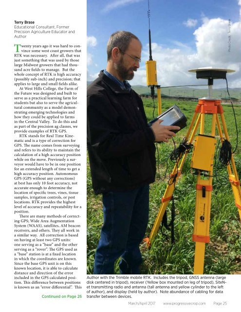
Author with the Trimble mobile RTK. Includes the tripod, GNSS antenna (large<br />
disk centered in tripod), receiver (Yellow box mounted on leg of tripod), SiteNet<br />
transmitting radio and antenna (tall antenna and yellow cylinder to the left<br />
of author), and display (held by author). Note abundance of cabling for data<br />
transfer between devices.<br />
<strong>Mar</strong>ch/<strong>Apr</strong>il <strong>2017</strong> www.progressivecrop.com Page 25<br />
Photo Credit: Terry Brase