
Create successful ePaper yourself
Turn your PDF publications into a flip-book with our unique Google optimized e-Paper software.
FIELDS IN<br />
KINGS WOOD Part 2...<br />
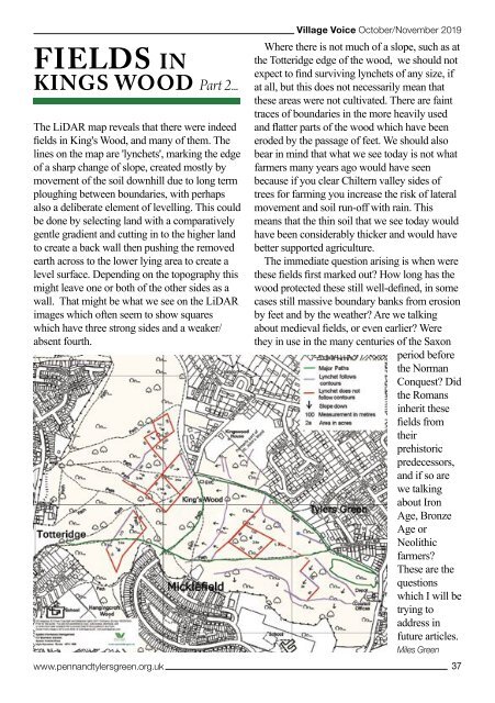
The LiDAR map reveals that there were indeed<br />
fields in King's Wood, and many of them. The<br />
lines on the map are 'lynchets', marking the edge<br />
of a sharp change of slope, created mostly by<br />
movement of the soil downhill due to long term<br />
ploughing between boundaries, with perhaps<br />
also a deliberate element of levelling. This could<br />
be done by selecting land with a comparatively<br />
gentle gradient and cutting in to the higher land<br />
to create a back wall then pushing the removed<br />
earth across to the lower lying area to create a<br />
level surface. Depending on the topography this<br />
might leave one or both of the other sides as a<br />
wall. That might be what we see on the LiDAR<br />
images which often seem to show squares<br />
which have three strong sides and a weaker/<br />
absent fourth.<br />
www.pennandtylersgreen.org.uk<br />
<strong>Village</strong> <strong>Voice</strong> <strong>Oct</strong>ober/<strong>Nov</strong>ember <strong>2019</strong><br />
Where there is not much of a slope, such as at<br />
the Totteridge edge of the wood, we should not<br />
expect to find surviving lynchets of any size, if<br />
at all, but this does not necessarily mean that<br />
these areas were not cultivated. There are faint<br />
traces of boundaries in the more heavily used<br />
and flatter parts of the wood which have been<br />
eroded by the passage of feet. We should also<br />
bear in mind that what we see today is not what<br />
farmers many years ago would have seen<br />
because if you clear Chiltern valley sides of<br />
trees for farming you increase the risk of lateral<br />
movement and soil run-off with rain. This<br />
means that the thin soil that we see today would<br />
have been considerably thicker and would have<br />
better supported agriculture.<br />
The immediate question arising is when were<br />
these fields first marked out? How long has the<br />
wood protected these still well-defined, in some<br />
cases still massive boundary banks from erosion<br />
by feet and by the weather? Are we talking<br />
about medieval fields, or even earlier? Were<br />
they in use in the many centuries of the Saxon<br />
period before<br />
the Norman<br />
Conquest? Did<br />
the Romans<br />
inherit these<br />
fields from<br />
their<br />
prehistoric<br />
predecessors,<br />
and if so are<br />
we talking<br />
about Iron<br />
Age, Bronze<br />
Age or<br />
Neolithic<br />
farmers?<br />
These are the<br />
questions<br />
which I will be<br />
trying to<br />
address in<br />
future articles.<br />
Miles Green<br />
37