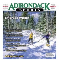
Adirondack Sports May 2020
In This Issue: BICYCLING - Find Your Own Trail Ride PADDLING - Lessons I Have Learned From the Publisher & News Briefs RUNNING - Running Reinvention HIKING & PACKPACKING - Big Bad Luck ATHLETE PROFILE - Mountain Biking with Anna Laloë CALENDAR OF EVENTS - Canceled, Postponed, Virtual & Happening Events! GREAT WALKS & DAY HIKES - Close to Home: Swift Wetland and Van Dyke Preserve
In This Issue:
BICYCLING - Find Your Own Trail Ride
PADDLING - Lessons I Have Learned
From the Publisher & News Briefs
RUNNING - Running Reinvention
HIKING & PACKPACKING - Big Bad Luck
ATHLETE PROFILE - Mountain Biking with Anna Laloë
CALENDAR OF EVENTS - Canceled, Postponed, Virtual & Happening Events!
GREAT WALKS & DAY HIKES - Close to Home: Swift Wetland and Van Dyke Preserve

Create successful ePaper yourself
Turn your PDF publications into a flip-book with our unique Google optimized e-Paper software.
18 <strong>Adirondack</strong> <strong>Sports</strong><br />
BICYCLING continued from 1<br />
Empire State Trail West, Pattersonville<br />
to Schoharie Crossing, 11.5 miles one-way<br />
– Any bike, paved, all off-road. This section<br />
of the Empire State Trail features five miles<br />
of brand-new paved trail going west from<br />
the small parking area at Pattersonville on<br />
NY Route 5S. As you go west, check out the<br />
imposing smokestacks of the Cranesville<br />
Block factory, the Erie Canal Lock 10 right<br />
next door, and watch for wildlife along the<br />
Mohawk River. Continue westward past the<br />
Amsterdam Castle on the hill and Erie Canal<br />
Lock 11 to the historic Schoharie Crossing<br />
Yankee Hill Lock. Visit the Schoharie<br />
Crossing State Historic Site nearby (518-829-<br />
7397), then turn around at the bridge over<br />
Schoharie Creek, or continue on half-a-mile<br />
more for some take out at Karen’s Produce &<br />
Ice Cream (518-829-7397).<br />
Warren County Bikeway, Glens Falls<br />
to Lake George, 10 miles one-way – Any<br />
bike, paved, mostly off-road, dogs prohibited.<br />
There’s abundant parking in Glens<br />
Falls for this trail that starts right around<br />
the corner from Grey Ghost Bicycles (518-<br />
223-0148). Head north toward Lake George<br />
through downtown Glens Falls, right past<br />
Cooper’s Cave Ale Company, where you<br />
can grab an ice cream cone or a drink. Just<br />
make sure to call first, as they are temporarily<br />
closed during the pandemic (518-<br />
792-0007). There’s a short distance (1.2<br />
miles) on Country Club Road before you<br />
enter the forest near Glen Lake, where you<br />
will finish climbing gently for the first eight<br />
miles from Glens Falls. Then descend past<br />
the foot of French Mountain and the Magic<br />
Forest Amusement Park to the trail’s end at<br />
Million Dollar Beach in Lake George with its<br />
steamboat rides, restaurants, taverns, and<br />
ice cream shops.<br />
Zim Smith Trail, Ballston Spa to<br />
Halfmoon, 9 miles one-way – Any bike,<br />
mix of gravel and paved, all off-road. This<br />
trail currently extends from Oak Street in<br />
Ballston Spa to Coon’s Crossing Road in<br />
Halfmoon – with work in progress to extend<br />
the trail into downtown Mechanicville.<br />
Mostly paved, it also has plenty of rest<br />
stops. Pause at Shenantaha Park, take a ride<br />
through the historic village of Round Lake,<br />
or grab a snack at Leah’s Cakery (518-899-<br />
5324) – right on the bike trail. For a post-ride<br />
detour, Lakeside Farms (518-399-8359), with<br />
cider donuts and much more, has recently<br />
reopened for the season.<br />
Fulton, Johnstown & Gloversville (FJ&G)<br />
Rail Trail, Johnstown to Gloversville, 8 miles<br />
one-way – Any bike, mostly paved, mostly<br />
off-road. This urban trail between the two<br />
Fulton County towns follows portions of the<br />
Cayadutta Creek, which was a central water<br />
source during the heyday of leather tanning<br />
in the area between 1880 and 1950. The trail<br />
alternates between neighborhood areas and<br />
EMPIRE STATE TRAIL: SCHOHARIE<br />
CROSSING YANKEE HILL LOCK<br />
ALONG THE MOHAWK RIVER WEST<br />
OF AMSTERDAM. PHOTOS BY<br />
DAVE KRAUS/KRAUSGRAFIK.COM<br />
WARREN COUNTY BIKEWAY.<br />
FULTON, JOHNSTOWN &<br />
GLOVERSVILLE RAIL TRAIL.<br />
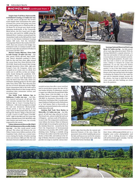
ASHOKAN RAIL TRAIL.<br />
wooded sections that offer a more rural feel,<br />
and in several places passes the sites of former<br />
leather factories. In Johnstown, stop for<br />
a ‘cuppa’ tea/coffee from Second Wind Coffee<br />
on Main Street (518-224-0386), or at the<br />
Mohawk Harvest Cooperative Market (518-<br />
706-0681) in downtown Gloversville a few<br />
blocks from Trail Station Park. Consider parking<br />
at Parkhurst Field just north of Johnstown<br />
or at Trail Station Park in Gloversville, as<br />
parking is extremely limited at the north and<br />
south ends of the trail.<br />
Ashokan Rail Trail, West Hurley to<br />
Boiceville, 11.5 miles one-way – Any bike,<br />
gravel, all off-road, dogs allowed on leash.<br />
This brand-new, almost totally flat trail west<br />
of Kingston – and just south of Woodstock –<br />
is a joy to ride. The compacted crushed stone<br />
route follows the former Ulster & Delaware<br />
railroad right of way along the north shore of<br />
the Ashokan Reservoir – owned by the New<br />
York City Department of Environmental<br />
Protection as it provides 40% of NYC’s daily<br />
drinking water. Parking is available along<br />
NY Route 28 at either end of the trail at West<br />
Hurley or Boiceville, and midway in the village<br />
of Shokan. Benches at regular intervals<br />
provide rest stops to read the various interpretive<br />
signs that describe the natural and<br />
historical features of the area. Enjoy the<br />
panoramic views of the Catskill peaks across<br />
the lake and keep an eye out for the remains<br />
of hundreds of hand-built stone walls that<br />
divided this former farmland.<br />
Saratoga National Historical Park Loop<br />
Road, 10.7 miles one lap – Any bike, paved,<br />
all on-road, dogs allowed on leash. While the<br />
Saratoga Battlefield is a popular attraction, it’s<br />
sheer size and number of trails and roads, give<br />
everyone plenty of room to maintain social distancing.<br />
During the pandemic, the park’s ninemile<br />
loop road is closed to cars until further<br />
notice, making it a bonanza for cyclists and<br />
pedestrians. As you ride, stop at the Neilson<br />
Farmstead that served as the Colonial headquarters,<br />
or one of the other historic markers<br />
across the park. Make sure to take the two short<br />
detours on the loop road that lead to the heights<br />
overlooking the Hudson River that made this<br />
spot such an important strategic resource for<br />
the colonies. Just keep in mind that the park<br />
visitor center and other buildings are closed<br />
due to the pandemic.<br />
Dave Kraus (dbkraus@earthlink.net) is a<br />
longtime area cyclist, photographer, and<br />
writer who is looking forward to riding<br />
with all his friends again someday. Visit his<br />
website at KrausGrafik.com.<br />
THE SARATOGA BATTLEFIELD’S<br />
LOOP ROAD PROVIDES ROOM<br />
TO SOCIAL DISTANCE FOR<br />
CYCLISTS AND PEDESTRIANS.