Adirondack Sports May 2020
In This Issue: BICYCLING - Find Your Own Trail Ride PADDLING - Lessons I Have Learned From the Publisher & News Briefs RUNNING - Running Reinvention HIKING & PACKPACKING - Big Bad Luck ATHLETE PROFILE - Mountain Biking with Anna Laloë CALENDAR OF EVENTS - Canceled, Postponed, Virtual & Happening Events! GREAT WALKS & DAY HIKES - Close to Home: Swift Wetland and Van Dyke Preserve
In This Issue:
BICYCLING - Find Your Own Trail Ride
PADDLING - Lessons I Have Learned
From the Publisher & News Briefs
RUNNING - Running Reinvention
HIKING & PACKPACKING - Big Bad Luck
ATHLETE PROFILE - Mountain Biking with Anna Laloë
CALENDAR OF EVENTS - Canceled, Postponed, Virtual & Happening Events!
GREAT WALKS & DAY HIKES - Close to Home: Swift Wetland and Van Dyke Preserve

Create successful ePaper yourself
Turn your PDF publications into a flip-book with our unique Google optimized e-Paper software.
HIKING & BACKPACKING<br />
Northern Frontier Camp<br />
(Private)<br />
MAY <strong>2020</strong> 9<br />
Big Bad<br />
Luck<br />
By Bill Ingersoll<br />
Often, the name of a backcountry landmark suggests<br />
an interesting tale. For instance, Calamity Pond in<br />
the High Peaks got its name when a gun accidentally<br />
discharged and killed a man. Good Luck Pond near Arietta<br />
was named when the same event occurred but no one was<br />
injured. Between those two ponds is Big Bad Luck Pond near<br />
Indian Lake. I’m sure there is a story here too, but so far, I<br />
haven’t come across it.<br />
There has been a marked hiking trail to Big Bad Luck<br />
and its neighbors for about 20 years, although ever since the<br />
opening of nearby OK Slip Falls to the public, the ponds have<br />
been getting short shrift. Since social distancing measures<br />
were first implemented in March there has been a crowding<br />
issue at the trailhead parking area, but I recently revisited the<br />
area confirmed that nearly everyone has been going to the<br />
waterfall. The branching trail network to the ponds has been<br />
cleared out this spring, but it sees far less use.<br />
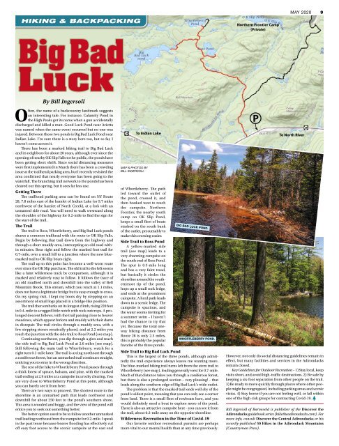
Getting There<br />
The trailhead parking area can be found on NY Route<br />
28, 7.8 miles east of the hamlet of Indian Lake (or 9.7 miles<br />
northwest of the hamlet of North Creek), at a fork with an<br />
unnamed side road. You will need to walk westward along<br />
the shoulder of the highway for 0.2-mile to find the sign for<br />
the start of the trail.<br />
The Trail<br />
The trail to Ross, Whortleberry, and Big Bad Luck ponds<br />
shares a common trailhead with the route to OK Slip Falls.<br />
Begin by following that trail down from the highway and<br />
through a short muddy area, intercepting an old road within<br />
minutes. Bear right and follow the marked foot trail for<br />
0.7-mile, over a small hill to a junction where the new bluemarked<br />
trail to OK Slip bears right.<br />
The trail up to this point has become a well-worn route<br />
ever since the OK Slip purchase. The old trail to the left seems<br />
like a faint wilderness track by comparison, although it is<br />
marked and relatively easy to follow. It follows the trace of<br />
an old roadbed north and downhill into the valley of Bell<br />
Mountain Brook. This stream, which you reach at 1.1 miles,<br />
does not have a legitimate bridge but is easy enough to cross.<br />
On my spring visit, I kept my boots dry by stepping on an<br />
assortment of small logs placed in a bridge-like position.<br />
The trail then embarks on its longest climb, rising 220 feet<br />
in 0.4-mile to a rugged little notch with rock outcrops. A prolonged<br />
descent follows, with the trail passing close to beaver<br />
meadows, which appear forlorn and muddy with their dams<br />
in disrepair. The trail circles through a muddy area, with a<br />
few stepping stones erratically placed, and at 2.2 miles you<br />
reach the junction with the side trail to Ross Pond (see map).<br />
Continuing northwest, you dip through a glen and reach<br />
the side trail to Big Bad Luck Pond at 2.6 miles (see map).<br />
Still following the main trail to Whortleberry, watch for a<br />
right turn 0.1-mile later. The trail is arcing northeast through<br />
a coniferous forest, but an unmarked trail continues straight,<br />
enticing you to stray in the wrong direction.<br />
The rest of the hike to Whortleberry Pond passes through<br />
a thick forest of spruce, balsam, and pine, with the marked<br />
trail ending at 2.9 miles at a campsite in a rocky clearing. You<br />
are very close to Whortleberry Pond at this point, although<br />
you can barely see it from here.<br />
There are two ways to proceed. The shortest route to the<br />
shoreline is an unmarked path that leads northwest and<br />
downhill for about 250 feet to the pond’s southern shore.<br />
This area is wooded and boggy, and the view of the pond will<br />
entice you to seek out something better.<br />
The better option used to be to follow another unmarked<br />
trail leading northeast from the campsite for 0.2-mile. I speak<br />
in the past tense because beaver flooding has effectively cut<br />
off easy foot access to the scenic campsite at the east end<br />
28<br />
MAP & PHOTOS BY<br />
BILL INGERSOLL<br />
To Indian Lake<br />
of Whortleberry. The path<br />
led toward the outlet of<br />
the pond, crossed it, and<br />
then hooked west to reach<br />
the campsite. Northern<br />
Frontier, the nearby youth<br />
camp on OK Slip Pond,<br />
keeps a small fleet of boats<br />
stashed on the south bank<br />
of the outlet, presumably to<br />
make this crossing easier.<br />
Side Trail to Ross Pond<br />
A yellow-marked side<br />
trail (see map) leads to a<br />
very charming campsite on<br />
the south end of Ross Pond.<br />
The spur is 0.3-mile long<br />
and has a very faint tread,<br />
but basically it circles the<br />
shoreline around the southernmost<br />
tip of the pond,<br />
hops up a small rock ledge,<br />
and ends at the prominent<br />
campsite. A herd path leads<br />
down to a scenic ledge. The<br />
campsite is spacious, and<br />
the water seems inviting for<br />
a summer swim – I haven’t<br />
had the chance to try that<br />
yet. Because the total oneway<br />
hiking distance from<br />
Route 28 is only 2.5 miles,<br />
this is probably the popular<br />
favorite of the three ponds.<br />
BIG BAD LUCK POND.<br />
WHORTLEBERRY POND.<br />
Side Trail to Big Bad Luck Pond<br />
This is the largest of the three ponds, although admittedly<br />
the trail experience always leaves me wanting more.<br />
The blue-marked hiking trail turns left from the stem trail to<br />
Whortleberry (see map), leading generally west for 0.7-mile.<br />
Much of that distance takes you through a coniferous forest,<br />
but there is also a prolonged section – very pleasing! – that<br />
leads along the southern edge of Big Bad Luck’s wide outlet.<br />
The problem is that the marked trail ends well shy of the<br />
pond’s widest point, meaning that you can only see a corner<br />
from land. There is a small fleet of rowboats here, and you<br />
would definitely need a boat to explore more of the pond.<br />
There is also an attractive campsite here – you can see it from<br />
the trail, about 0.2-mile away on the opposite shoreline.<br />
Wilderness Recreation in the Time of Covid-19<br />
Our favorite outdoor recreational pursuits are perhaps<br />
more vital to our mental health than at any time previously.<br />
P<br />
To North River<br />
However, not only do social distancing guidelines remain in<br />
effect, but many facilities and services in the <strong>Adirondack</strong>s<br />
remain closed.<br />
Key Guidelines for Outdoor Recreation – 1) Stay local, keep<br />
visits short, and avoid high-traffic destinations. 2) Be safe by<br />
keeping a six-foot separation from other people on the trail.<br />
3) Be ready to move quickly through places where other people<br />
might be congregated, including parking areas and scenic<br />
vistas. 4) Stay home if you are not feeling well, or fall within<br />
one of the high-risk groups for contracting Covid-19.<br />
Bill Ingersoll of Barneveld is publisher of the Discover the<br />
<strong>Adirondack</strong>s guidebook series (hiketheadirondacks.com). For<br />
more info, consult Discover the Central <strong>Adirondack</strong>s or his<br />
recently-published 50 Hikes in the <strong>Adirondack</strong> Mountains<br />
(Countryman Press).<br />
28