Northern Ecological Services report Appendices 1-8 - Transport ...
Northern Ecological Services report Appendices 1-8 - Transport ...
Northern Ecological Services report Appendices 1-8 - Transport ...
You also want an ePaper? Increase the reach of your titles
YUMPU automatically turns print PDFs into web optimized ePapers that Google loves.
Second Forth Crossing at Kincardine, Stage 2 <strong>Ecological</strong> Impact Assessment – Volume Three<br />
__________________________________________________________________________________<br />
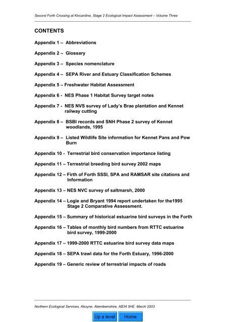
CONTENTS<br />
Appendix 1 – Abbreviations<br />
Appendix 2 – Glossary<br />
Appendix 3 – Species nomenclature<br />
Appendix 4 – SEPA River and Estuary Classification Schemes<br />
Appendix 5 – Freshwater Habitat Assessment<br />
Appendix 6 - NES Phase 1 Habitat Survey target notes<br />
Appendix 7 - NES NVS survey of Lady’s Brae plantation and Kennet<br />
railway cutting<br />
Appendix 8 – BSBI records and SNH Phase 2 survey of Kennet<br />
woodlands, 1995<br />
Appendix 9 – Listed Wildlife Site information for Kennet Pans and Pow<br />
Burn<br />
Appendix 10 - Terrestrial bird conservation importance listing<br />
Appendix 11 – Terrestrial breeding bird survey 2002 maps<br />
Appendix 12 – Firth of Forth SSSI, SPA and RAMSAR site citations and<br />
Information<br />
Appendix 13 – NES NVC survey of saltmarsh, 2000<br />
Appendix 14 – Logie and Bryant 1994 <strong>report</strong> undertaken for the1995<br />
Stage 2 Comparative Assessment.<br />
Appendix 15 – Summary of historical estuarine bird surveys in the Forth<br />
Appendix 16 – Tables of monthly bird numbers from RTTC estuarine<br />
bird survey, 1999-2000<br />
Appendix 17 – 1999-2000 RTTC estuarine bird survey data maps<br />
Appendix 18 – SEPA trawl data for the Forth Estuary, 1996-2000<br />
Appendix 19 – Generic review of terrestrial impacts of roads<br />
__________________________________________________________________________________<br />
<strong>Northern</strong> <strong>Ecological</strong> <strong>Services</strong>, Aboyne, Aberdeenshire, AB34 5HE. March 2003
Upper Forth Crossing at Kincardine, Stage 3 <strong>Ecological</strong> Impact Assessment – Volume Three<br />
_________________________________________________________________________________<br />
APPENDIX 1<br />
ABBREVIATIONS<br />
__________________________________________________________________<br />
<strong>Northern</strong> <strong>Ecological</strong> <strong>Services</strong>, Aboyne, Aberdeenshire, July 2003
Abbreviations<br />
ASPT Average Score Per Taxon<br />
AWI Ancient Woodland Inventory<br />
BAP Biodiversity Action Plan<br />
BMWP Biological Monitoring Working Party<br />
BoEE Birds of Estuaries Enquiry<br />
BSBI Botanical Society of the British Isles<br />
CARSE Central Area Recording System for the Environment (Wildlife Record Centre<br />
for Central Scotland)<br />
CEH Centre for Hydrology and Hydrology<br />
DETR department of the Environment and Regions<br />
DMRD Design Manual for Roads and Bridges<br />
ECC European Communities Council<br />
EcIA <strong>Ecological</strong> Impact Assessment<br />
EIA Environmental Impact Assessment<br />
ELR Eastern Link Road<br />
FRPB Forth River Purification Board<br />
HAP Habitat Action Plan<br />
IEEM Institute for Ecology and Environmental Management<br />
IWC International Wildlife Count<br />
LBAP Local Biodiversity Action Plan<br />
LTC Low Tide Count<br />
NATA New Approach to Assessment<br />
NCC Nature Conservancy Council<br />
NES <strong>Northern</strong> <strong>Ecological</strong> <strong>Services</strong><br />
NPPG National Planning Policy Guideline<br />
NVC National Vegetation Classification<br />
OD Ordnance datum<br />
PAN Planning Advice Note<br />
RTTTC Random Through The Tide Count<br />
RSPB Royal Society for the Protection of Birds<br />
SAP Species Action Plan<br />
SEDD Scottish Executive Development Department<br />
SEPA Scottish Environment Protection Agency<br />
SNH Scottish Natural Heritage<br />
SPA Special Protection Area<br />
SOC Scottish Ornithologist Club<br />
SSSI Site of Special Scientific Interest<br />
SS Suspended sediment<br />
STAG Scottish <strong>Transport</strong> Appraisal Guidance<br />
SWT Scottish Wildlife Trust<br />
TTTC Through the Tide Count<br />
WCA Wildlife and Countryside Act<br />
WeBS Wetland Bird Survey<br />
WFD Water Framework Directive<br />
WWT Wildfowl and Wetlands Trust
Upper Forth Crossing at Kincardine, Stage 3 <strong>Ecological</strong> Impact Assessment – Volume Three<br />
_________________________________________________________________________________<br />
APPENDIX 2<br />
GLOSSARY<br />
__________________________________________________________________<br />
<strong>Northern</strong> <strong>Ecological</strong> <strong>Services</strong>, Aboyne, Aberdeenshire, July 2003
GLOSSARY<br />
Abiotic The non-living components of the environment that directly affect plant<br />
and animal life, e.g. water, carbon dioxide, oxygen, light, climate, etc.<br />
Bioaccumulation Concentration of substances in plant and animal tissue, increasing<br />
up the food chain (also see Trophic level)<br />
Biodiversity/species<br />
diversity<br />
Biological diversity, or the richness of living organisms present in<br />
representative populations<br />
Biomass The total weight (or volume) of either all the living organisms or of<br />
one species present in a community at any one time<br />
Brackish Slightly salty water, often occurring where freshwater meets the sea<br />
and forming a discrete habitat<br />
Bryophytes Mosses and liverworts<br />
Canalised To convert a river or stream into a canal (usually mechanically)<br />
Carrying capacity The maximum number of organisms or amount of biomass that can<br />
be supported in a given area<br />
Demersal Living or occurring in deep water<br />
Dispersal The spread of seeds (plants) or animals into new areas.<br />
Drey A squirrels nest<br />
Emergent plants Plants that grow in water bodies and grow clear of the surface (i.e.<br />
do not float or remain submerged)<br />
Escarpment The long continuous steep face of a ridge or plateau<br />
Ferruginous Containing iron-rust or iron as a chemical constituent<br />
Floodplain The flat area bordering a river composed of sediment deposited<br />
during flooding<br />
Flyway Corridor along which migratory birds pass<br />
Foraging area Area over which n animal regularly searches for food<br />
Functional<br />
equivalency<br />
Working in a similar way (often referring to a restored habitat<br />
performing similarly to a natural habitat)<br />
Geomorphology The branch of geology that is concerned with the structure, origin<br />
and development of topographical features of the earth’s crust<br />
Habitat Term most accurately meaning the place in which a species lives, but<br />
also used to describe plant communities or agglomerations of plant<br />
communities, as used, for example in the Phase 1 Habitat Survey<br />
Habituate Become accustomed to<br />
Hibernacula Roost in which bats hibernate over-winter<br />
Holt An otter lair<br />
Improved<br />
grassland/pasture<br />
Grassland that has been subject to a level of fertilisation and, or<br />
weed control (but not reseeded) to the extent that most of the<br />
original species have disappeared, leaving a low number of<br />
dominant vigorous species, with a resultant low species richness.<br />
(Reseeded leys are classed as arable –see Leys).<br />
Semi-improved – grassland that has been subject to some<br />
fertilisation and, or weed control, but which still retains some species<br />
characteristic of the unimproved state<br />
Unimproved – grassland that has not been subject to fertilisation and,<br />
or weed control and which is usually species-rich<br />
Infauna The fauna living within the substrate in saltmarsh and mudflat<br />
habitat, usually comprising mostly invertebrate species.
Key species Species whose national (or inter-national) rarity and/or dependence<br />
on rare or threatened habitat makes them important in the context of<br />
the site<br />
Leys Arable land temporarily under grass (also see Improved<br />
grassland/pasture)<br />
Managed retreat The planned creation of intertidal habitat on land formerly reclaimed<br />
from the sea by the breaching or removal of the seawall to allow tidal<br />
inundation. Undertaken to counter loss of intertidal habitat and as a<br />
soft engineering technique of coastal defence to alleviate flood risk<br />
and counter the effect of rising sea levels.<br />
Metapopulations Populations that comprise several sub-populations of a species<br />
inhabiting patches of habitat, but with some immigration and<br />
emigration between patches to maintain an interconnected population<br />
Natural setback sites Sites that have developed intertidal habitat after natural breaching of<br />
the seawall<br />
Nekton Fish and large, mobile invertebrates<br />
Notable species<br />
(invertebrates)<br />
Notable species<br />
(flora)<br />
Scarce invertebrate species - occurring in 16-100 km squares in<br />
Britain<br />
Scarce plant species – occurring in 16-100 km squares in Britain<br />
Planned retreat See Managed retreat<br />
Organic carbon flux Interchange of carbon between plant and animal tissues and the<br />
atmosphere<br />
Otter couch An otter resting place<br />
Pelagic Living or occurring in the upper waters of the open sea<br />
Pioneer species<br />
/habitats<br />
/communites<br />
The first species/habitat/community to colonise bare rock and/or soil<br />
(usually algae or lichens) (also see Succession)<br />
Population viability Capable of normal growth and development and thus of sustaining<br />
the population<br />
Quadrat Species lists and estimates of the ground covered by a plant species<br />
in a defined sample area (e.g. 2m x 2m)<br />
Rank vegetation Vegetation showing vigorous and profuse growth (often unmanaged)<br />
Receptor habitats Those habitats or species subject to the impacts of a proposal<br />
Saltmarsh Inter-tidal sand-, silt- or mud-based habitats colonised by halophytic<br />
(salt tolerant) plant species.<br />
Sample data Data which have been collected from some members of a statistical<br />
population and which are usually assumed to be representative of<br />
the whole population<br />
Scrub Habitat consisting of deciduous scrub species, i.e. gorse, broom,<br />
some willow species, brambles, etc. and/or naturally regenerating<br />
saplings of tree species<br />
Semi-natural<br />
vegetation<br />
Vegetation which has been modified by humans but is still of<br />
significant nature conservation interest because it is composed of<br />
native plant species, is similar in structure to natural types and<br />
supports native animal communities<br />
Set-aside Agricultural land temporarily taken out of production<br />
Setback Breaching of the sea wall to allow tidal inundation of land formerly<br />
reclaimed from the sea with the development of new intertidal habitat.<br />
Natural setback involves natural or accidental breaching of the sea
wall.<br />
Site integrity The integrity of a site is the coherence of its ecological structure and<br />
function, across its whole area, that enables it to sustain the habitat,<br />
complex of habitats and/or levels of populations for which it was<br />
classified<br />
Spatial scales Data recorded at different areas/levels and/or applied to different<br />
areas/levels, e.g. national, regional or local<br />
Species abundance Species abundance can be recorded using the DAFOR scale<br />
Dominant, Abundant, Frequent, Occasional, Rare. Locally can be<br />
used in conjunction with dominant, abundant and frequent, thus: LD,<br />
LA, LF.<br />
Species<br />
diversity/biodiversity<br />
Biological diversity, or the richness of living organisms present in<br />
representative populations<br />
Species richness The total number of (often plant) species present in a community or<br />
habitat<br />
Spraint Otters dung<br />
Succession A series of changes in the composition of the plant or animal life of<br />
an area beginning with the colonisation of bare rock or soil by plants<br />
such as algae and lichens (see Pioneer species/ habitats/<br />
communites) and ending with a stable climax community, which is<br />
in equilibrium with the environment. Such a primary succession<br />
can take a number of years to complete. A secondary succession<br />
can occur where the original vegetation community has been<br />
destroyed, e.g. by burning, and can be completed in a shorter time.<br />
Synergy The working together of two or more impacts (positive and/or<br />
negative) to produce an effect greater than the sum of their individual<br />
effects<br />
Threshold The minimum intensity or value of a signal, etc., that will produce a<br />
response or specified effect<br />
Threshold number The minimum number of a species present in a plant or animal<br />
population at which the population is sustainable<br />
Tidal prism The volume of water exchanged on each tidal cycle within an<br />
estuary.<br />
Trophic level Different levels in the food chain. Green plants (primary producers)<br />
are the first level, followed by herbivores and then carnivores –<br />
together forming a food web<br />
Vigour The capacity for survival or strong healthy growth in plants or<br />
animals<br />
Walkover survey A rapid survey carried out while walking through a site
Upper Forth Crossing at Kincardine, Stage 3 <strong>Ecological</strong> Impact Assessment – Volume Three<br />
_________________________________________________________________________________<br />
APPENDIX 3<br />
SPECIES NOMENCLATURE<br />
__________________________________________________________________<br />
<strong>Northern</strong> <strong>Ecological</strong> <strong>Services</strong>, Aboyne, Aberdeenshire, July 2003
SPECIES NOMENCLATURE<br />
Plants<br />
Scientific names are taken from Stace C (1997) New Flora of the British Isles, Second Ed.<br />
Cambridge University Press<br />
Common Name Scientific name<br />
alder Alnus glutinosa<br />
angelica Angelica sylvestris<br />
arrowgrass, sea Triglochin maritimum<br />
arum lily Arum maculatum<br />
ash Fraxinus excelsior<br />
aster, rayless sea Aster tripolium var. discoideus<br />
avens, wood Geum urbanum<br />
beech Fagus sylvatica<br />
bent, creeping Agrostis stolonifera<br />
bindweed, hedge Calystegia sepium<br />
birch Betula sp.<br />
bird's-foot trefoil Lotus corniculatus<br />
bittercress, wavy Cardamine flexuosa<br />
bittersweet Solanum dulcamara<br />
blackthorn Prunus spinosa<br />
bluebell Hyacinthoides non-scripta<br />
bracken Pteridium aquilinum<br />
bramble Rubus fruiticosus<br />
brome, slender false Brachypodium sylvaticum<br />
brooklime Veronica beccabunga<br />
broom Cytisus scoparius<br />
buckler-fern, broad Dryopteris dilatata<br />
buckler-fern, narrow Dryopteris carthusiana<br />
bulrush (reedmace) Typha latifolia<br />
bur-reed, branched Sparganium erectum<br />
bur-reed, unbranched Sparganium emersum<br />
buttercup, celery-leaved Ranunculus sceleratus<br />
buttercup, creeping Ranunculus repens<br />
campion, red x white cross Silene dioica x latifolia<br />
campion, red Silene dioica<br />
canary-grass, reed Phalaris arundinacea<br />
celandine, lesser Ranunculus ficaria<br />
cherry Prunus sp.<br />
chestnut, sweet Castanea sativa<br />
cleavers Galium aparine<br />
clover, white Trifolium repens<br />
clover, zig-zag Trifolium medium<br />
club-rush, sea Bolboschoenus maritimus<br />
cocksfoot Dactylis glomerata<br />
comfrey Symphytum officinale<br />
comfrey, tuberous Symphytum tuberosum<br />
corydalis, climbing Ceratocapnos claviculata<br />
couch, common Elymus repens<br />
dead-nettle, white Lamium album<br />
dock Rumex sp.<br />
dock, broad-leaved Rumex obtusifolius<br />
dock, wood Rumex sanguineus<br />
dog-rose Rosa canina<br />
dog’s mercury Mercuralis perennis<br />
dog-violet Viola riviniana
duckweed Lemna sp.<br />
elder Sambucus nigra<br />
elm Ulmus sp.<br />
elm, wych Ulmus glabra<br />
enchanter's-nightshade Circaea lutetiana<br />
Enteromorpha (green algae)<br />
fat-hen Chenopodium album<br />
fern, lady Athyrium filix-femina<br />
fern, male Dryopteris felix-mas<br />
fern, scaly male Dryopteris affinis<br />
fescue, red Festuca rubra<br />
fescue, rush-leaved Festuca arenaria<br />
fescue, tall Festuca arundinacea<br />
figwort, common Scrophularia nodosa<br />
foxglove Digitalis purpurea<br />
fox-sedge, false Carex otrubae<br />
foxtail, marsh Alopecurus geniculatus<br />
foxtail, meadow Alopecurus pratensis<br />
glasswort, common Salicornia europaea<br />
glasswort, long-spiked Salicornia dolichostachya<br />
gorse Ulex europaeus<br />
grass, timothy Phleum pratense<br />
ground-elder Aegopodium podograria<br />
hair-grass, tufted Deschampsia cespitosa<br />
hawkbit, autumn Leontodon autumnalis<br />
hawthorn Crataegus monogyna<br />
hedge-parsley, upright Torilis japonica<br />
herb-robert Geranium robertianum<br />
hogweed Heracleum sphondylium<br />
honeysuckle Lonicera periclymenum<br />
horehound, black Ballota nigra<br />
hornbeam Carpinus betulus<br />
horse-chestnut Aesculus hippocastanum<br />
horsetail Equisetum sp.<br />
horsetail, field Equisetum arvense<br />
ivy Hedera helix<br />
knapweed, black Centaurea nigra<br />
knapweed, greater Centaurea scabiosa<br />
knotgrass Polygonum aviculare<br />
lady's mantle Alchemilla vulgaris<br />
larch Larix decidua<br />
lesser celandine Ranunculus ficaria<br />
lime Tilia x europaea<br />
lords-and-ladies Arum maculatum<br />
maple, field Acer campestre<br />
marsh-marigold Caltha palustris<br />
mayweed, sea Tripleuropspermum maritimum<br />
meadow-grass, annual Poa annua<br />
meadow-grass, broad-leaved Poa chaixii<br />
meadow-grass, wood Poa nemoralis<br />
meadowsweet Filipendula ulmaria<br />
mercury, dog's Mercurialis perennis<br />
milkwort, sea Glaux maritima<br />
mouse-ear, common Cerastium fontanum<br />
mugwort Artemisia vulgaris<br />
musk-mallow Malva moschata<br />
mustard, garlic Alliaria petiolata<br />
nettle, common Urtica dioica<br />
oak Quercus sp.<br />
oat-grass, false Arrhenatherum elatius
orache, spear-leaved Atriplex prostrata<br />
parsley, cow Anthriscus sylvestris<br />
pearlwort, sea Sagina maritima<br />
pignut Conopodium majus<br />
pimpernel, yellow Lysimachia nemorum<br />
pine, Scots Pinus sylvestris<br />
plantain, ribwort Plantago lanceolata<br />
plantain, sea Plantago maritima<br />
poa, wood Poa nemoralis<br />
pondweed, broad-leaved Potamogeton natans<br />
pondweed, Canadian Elodea canadensis<br />
poplar Populus sp<br />
primrose Primula vulgaris<br />
ragwort Senecio jacobaea<br />
raspberry Rubus idaeus<br />
redshank Persicaria maculosa<br />
reed, common Phragmites australis<br />
reedmace Typha latifolia<br />
rhododendron Rhododendron ponticum<br />
Rhytidiadelphus squarrosus (lawn moss)<br />
rose Rosa sp.<br />
rosebay willowherb Chamerion angustifolium<br />
rowan Sorbus aucuparia<br />
rush, hard Juncus inflexus<br />
rush, saltmarsh Juncus gerardii<br />
rush, soft Juncus effusus<br />
saltmarsh grass Puccinellia sp.<br />
saltmarsh grass, common Puccinellia maritima<br />
salt-marsh grass, reflexed Puccinellia distans<br />
sandwort, sea Honckenya peploides<br />
sandwort, three-veined Moehringia trinervia<br />
scurvygrass, common Cochlearia officinalis<br />
sea-spurrey, lesser Spergularia marina<br />
sedge, pendulous Carex pendula<br />
selfheal Prunella vulgaris<br />
soapwort Saponaria officinalis<br />
Solomon's seal Polygonatum multiflorum<br />
sowthistle, perennial Sonchus arvensis<br />
spruce Picea sp.<br />
St John's wort, perforated Hypericum perforatum<br />
stitchwort, lesser Stellaria graminea<br />
strawberry, wild Fragaria vesca<br />
sweet-grass, floating Glyceria fluitans<br />
sweet-grass, reed Glyceria maxima<br />
sycamore Acer pseudoplatanus<br />
thistle, creeping Cirsium arvense<br />
thrift Armeria maritima<br />
toadflax, common Linaria vulgaris<br />
twayblade, common Listera ovata<br />
valerian, common Valeriana officinalis<br />
violet, common dog Viola riviniana<br />
watercress Rorippa nasturtium-aquaticum<br />
water-crowfoot, stream Ranunculus penicillatus subsp. pseudofluitans<br />
water-plantain Alisma plantago-aquatica<br />
water-starwort, common Callitriche stagnalis<br />
willow, crack Salix fragilis<br />
willow, goat Salix caprea<br />
willow, grey Salix cinerea<br />
willow, white Salix alba<br />
willowherb, American Epilobium ciliatum
willowherb, great Epilobium hirsutum<br />
woundwort, hedge Stachys sylvatica<br />
Yorkshire-fog Holcus lanatus<br />
Fauna<br />
Mammals<br />
Common Name Scientific name<br />
badger Meles meles<br />
bat, Daubenton’s Myotis daubentonii<br />
bat, pipistrelle Pipistrelle pygmeaus<br />
Pipistrelle pipistrellus<br />
Dolphin, Atlantic white-sided Lagenorhynchus acutus<br />
dolphin, bottlenose Turciops truncatus<br />
porpoise, harbour Phocoena phocoena<br />
otter Lutra lutra<br />
seal, common Phoca vitulina<br />
seal, grey Halichoerus grypus<br />
water vole Arvicola terrestris<br />
whale, minke Balaenoptera acutorostrata<br />
Birds<br />
Common Name Scientific name<br />
barn owl Tyto alba<br />
blackbird Turdus merula<br />
blackcap Sylvia atricapilla<br />
buzzard Buteo buteo<br />
chaffinch Fringilla coelebs<br />
cuckoo Cuculus canorus<br />
dunnock Prunella modularis<br />
fieldfare Turdus pilaris<br />
goldfinch Carduelis carduelis<br />
greenfinch Carduelis chloris<br />
heron, grey Ardea cinerea<br />
linnet Carduelis cannabina<br />
mallard Anas platyrhynchos<br />
partridge, grey Perdix perdix<br />
pied wagtail Motacilla cinerea<br />
pigeon, wood Columba palumbus<br />
redwing Turdus iliacus<br />
reed bunting Emberiza cirlus<br />
robin Erithacus rubecula<br />
short-eared owl Asio flammeus<br />
skylark Alauda arvensis<br />
song thrush Turdus philomelos<br />
starling Sturnus vulgaris<br />
swallow Hirundo rustica<br />
tit, blue Parus caeruleus<br />
tit, great Parus major<br />
twite Carduelis flavirostris<br />
warbler, sedge Acrocephalus schoenobaenus
warbler, willow Phylloscopus trochilus<br />
wheatear Oenanthe oenanthe<br />
whitethroat Sylvia communis<br />
wren Troglodytes troglodytes<br />
yellowhammer Emberiza citrinella<br />
Amphibians<br />
Common Name Scientific name<br />
frog, common Rana temporaria<br />
newt, palmate Triturus helveticus<br />
toad, common Bufo bufo<br />
Fish and estuarine invertebrates<br />
cod Gadus morhua<br />
crab, shore Carcinus maenas<br />
eel Anguilla anguilla<br />
flounder Pleuronectus flesus<br />
goby, sand or common Pomatoschistus microps<br />
herring Clupea harengus<br />
lamprey, river Lampetra fluviatilis<br />
pipefish Sygnathus acus<br />
plaice Pleuronectus platessa<br />
trout Salmo trutta<br />
salmon Salmo salar<br />
shrimp, brown Crangon crangon<br />
smelt or sparling Osmerus eperlanus<br />
sprat Sprattus sprattus<br />
stickle-back, three spined Gasterosteus aculeatus<br />
whiting Merlangius merlangus
Upper Forth Crossing at Kincardine, Stage 3 <strong>Ecological</strong> Impact Assessment – Volume Three<br />
_________________________________________________________________________________<br />
APPENDIX 4<br />
SEPA RIVER AND ESTUARY CLASSIFICATION SCHEMES<br />
__________________________________________________________________<br />
<strong>Northern</strong> <strong>Ecological</strong> <strong>Services</strong>, Aboyne, Aberdeenshire, July 2003
Upper Forth Crossing at Kincardine, Stage 3 <strong>Ecological</strong> Impact Assessment – Volume Three<br />
_________________________________________________________________________________<br />
APPENDIX 5<br />
FRESHWATER HABITAT ASSESSMENT<br />
__________________________________________________________________<br />
<strong>Northern</strong> <strong>Ecological</strong> <strong>Services</strong>, Aboyne, Aberdeenshire, July 2003
Scottish Executive Development Department<br />
Upper Forth Crossing At Kincardine<br />
Freshwater Habitat Assessment<br />
1.1 Freshwater Habitat<br />
A preliminary assessment of water quality and conservation value of potentially affected watercourses<br />
was undertaken by conducting a survey of two watercourses (Canal Burn and the outflow from<br />
Donalds Dam), which were sampled to the north of Kennet Pans on the north bank of Forth Estuary. In<br />
addition, data was available from a survey of a freshwater site (<strong>Northern</strong> Drain sometimes known as<br />
Powfoulis Burn) on the south bank, near Skinflats (Babtie 2003).<br />
1.1.1 Methods<br />
Baseline<br />
Three burns/drains were sampled using the same method, two on the north shore of the Forth estuary<br />
were sampled on 16 April 2003 and an additional site was sampled as part of another study (Babtie<br />
2003) on the 19 November 2002. Sites were sampled for aquatic invertebrates and a general habitat<br />
assessment based on River Habitat Survey techniques was undertaken (EA 2003). The survey<br />
method involved a walk along the burn and surrounding areas to assess the variation in nature of the<br />
burn and the adjacent land use and the selection of sites to show any variation in water quality/<br />
aquatic invertebrate populations.<br />
Macroinvertebrate sampling was undertaken by kick sampling for at least 10 metres with a 250µm<br />
mesh Freshwater Biological Association (FBA) net followed by visual observation to find any further<br />
specimens. Samples were emptied into a white tray and ‘live picked’ for 30 minutes to obtain a<br />
representative sample of macroinvertebrates from the sample. Care was taken to search for small<br />
and/or cryptic species and specimens were preserved in 70% ethanol and retained for identification.<br />
Aquatic invertebrates collected were identified to species level where possible using a low powered<br />
microscope and appropriate taxonomic keys.<br />
Simple water quality measurements were taken in situ and River Habitat Assessment sheets were<br />
used to record physical conditions at the site.<br />
<strong>Ecological</strong> Quality Assessment<br />
A simple scheme for the preliminary ecological assessment of watercourses based on the aquatic<br />
invertebrate assemblage was used. The scheme is based on the relative pollution tolerance of<br />
invertebrate species and scores various invertebrate families based on pollution tolerance. Adding<br />
these scores gives an index of the ecological quality of a watercourse, known as the Biological<br />
Monitoring Working Party (BMWP) score, and dividing this score by the number of species sampled<br />
gives the Average Species Pollution Tolerance (ASPT) score This index, along with a measure of<br />
species richness, some simple in situ water quality measurements, and combined with habitat<br />
descriptions give an assessment of a burn’s ecological status. This status can then be used to<br />
determine the sensitivity of the habitat.
Scottish Executive Development Department<br />
Upper Forth Crossing At Kincardine<br />
Freshwater Habitat Assessment<br />
1.1.2 Site Descriptions<br />
Three waterways were identified as potentially affected by the new bridge crossing, Powfoulis Burn<br />
(<strong>Northern</strong> Drain) (Site 1) on the southern side of the Forth Estuary and Canal Burn and Donalds Dam<br />
Outflow (sites 2 and 3) located close to each other on the northern shore. All three streams were<br />
located within flat improved pasture, rough grassland and arable fields. Site 1 was a straightened<br />
channel that was embanked on both sides, Site 2 was a steep sided meandering burn running through<br />
arable land downstream of the Killbagie Paper Mill and Site 3 was a straightened stream downstream<br />
from a culverted section. Detailed site descriptions are given in Table 1.
Scottish Executive Development Department<br />
Upper Forth Crossing At Kincardine<br />
Freshwater Habitat Assessment<br />
Table 1: Site Descriptions for the three Freshwater Sites<br />
Site<br />
Location<br />
Site 1<br />
<strong>Northern</strong><br />
Burn/<br />
Powfoulis<br />
Burn<br />
NS<br />
2922 6849<br />
Site 2<br />
Canal Burn<br />
NS<br />
2921 6888<br />
Site 3<br />
Donalds<br />
Dam<br />
Outflow<br />
(Culverted<br />
Burn)<br />
NS<br />
2925 6896<br />
Main Channel Description Bank Side Description<br />
Straightened, with a water width of 1.5m and depth of 30cm. Water was<br />
clear, with unbroken, uniform flow (glide) along reach and was under<br />
tidal influence. The substrate was composed of unconsolidated silt and<br />
mud with abundant mollusc shells and leaf packs, which produced a<br />
large plume when disturbed. There was no channel vegetation although<br />
there were infrequent areas of course woody debris and tree roots at the<br />
water’s edge.<br />
Meandering channel with a water width of 1.25m and depth of 20cm.<br />
Water was very turbid and reddish in colour, with unbroken, uniform flow<br />
(glide) along reach. The substrate was composed of clay and silt, which<br />
produced a large reddish plume when disturbed. There was no instream<br />
vegetation although there were regular areas of course woody debris,<br />
leafy debris, filamentous algae and fringing reed-banks.<br />
Narrow modified channel downstream from two culverted sections with a<br />
water width of 1.2 and depth of 15cm. Water was clear with a variety of<br />
flow types including rippled and smooth flow with some marginal areas<br />
of dead water along reach. The substrate was mainly composed of<br />
gravel and pebbles with some cobbles and exposed boulders with a<br />
covering of silt over all surfaces, which produced a large plume when<br />
disturbed. There were limited areas of channel vegetation dominated by<br />
watercress and some woody debris and exposed and underwater tree<br />
roots.<br />
The burn was embanked and steeply sloping to the main<br />
channel. Banktop height was ~ 5m and the bankfull height<br />
was 3m (i.e. channel embanked by 2m). There were areas<br />
of bare earth (sticky clay) and uniform vegetation on the<br />
bank face and simple tall herb vegetation on the bank top<br />
with occasional clumps of trees on the left bank and semicontinuous<br />
trees set back from the right bank.<br />
The burn had steeply sloping banks to the main channel<br />
with some unstable eroding areas. Banktop/bankfull height<br />
was ~2.5m. There were areas of bare earth and uniform<br />
vegetation on the bank face and isolated/scattered trees<br />
along the bank.<br />
The dam outflow was steeply sloping to the main channel.<br />
Banktop/bankfull height was 1.2m and 3.5 m wide. The bank<br />
was covered with uniform vegetation rank with occasional<br />
trees along the bank. There was evidence of recent<br />
management in the form of weed cutting and bank mowing<br />
with the survey reach.
Scottish Executive Development Department<br />
Upper Forth Crossing At Kincardine<br />
Freshwater Habitat Assessment<br />
1.1.3 Water Quality and Macroinvertebrates<br />
Water quality parameters were within acceptable ranges for supporting in-stream biota (Table 2).<br />
Water temperature was typical for the time of year, being lower at site one (~6 0 C) which was sampled<br />
in November than the other two sites (~12 0 C), which were sampled in April. Electrical conductivity<br />
was slightly high at Site 2 but well below that of seawater. Since ‘spot measures’ cannot be strictly<br />
applied to the SEPA River Classification the following assessments for dissolved oxygen and pH are<br />
indicative only. Dissolved oxygen levels measured as %saturated were: Site 1 – ‘good’, Site 2 – ‘poor’<br />
and Site 3 – ‘excellent’. All three sites had pH values close to neutral, within the ‘excellent’ category.<br />
Table 2: Water quality measurements taken in situ for three sample sites<br />
Site Date Temperature<br />
(°C)<br />
Electrical<br />
Conductivity<br />
(µS/cm)<br />
Dissolved Oxygen<br />
(mg/l) (%saturated)<br />
Site 1 19-11-03 6.6 502 8.86 (74%) 7.4<br />
Site 2 16-4-03 11.1 824 5.81 (53%) 6.8<br />
Site 3 16-4-03 13.2 675 10.2 (96%) 6.9<br />
On the southern side of the estuary the macroinvertebrate assemblage for Site 1 had low species<br />
diversity and low abundance (Table 3). Site 1 had a total abundance of 19 with 8 species. The faunal<br />
community was composed of mainly pollution tolerant species as measured by BMWP and the ASPT<br />
score placed the site around the boundary between the poor and fair SEPA classifications 1 .<br />
Site 2 had a low to moderately diverse fauna with 67 individuals from 12 species which were mostly<br />
from taxa that are found in slow flowing silty waterways and some also associated with ferric<br />
discharges. The ASPT score for this site (3.91) was the lowest ASPT score of all three sites<br />
suggesting that these species are more pollution tolerant than the other two sites. This places it within<br />
the poor category in the SEPA classification scheme.<br />
Site 3 (where one unidentified fish fry was observed) had the greatest species diversity and<br />
abundance (20 and 109 respectively) of the three sites and had the highest BMWP score of 94<br />
indicating that it included a number of pollution sensitive species. The ASPT score placed Site 3 in<br />
the good category in the SEPA classification scheme.<br />
All three sites did not include any rare species and Site 1 on the southern side of the estuary and site<br />
2 on the northern side were assessed as of poor condition while the outflow from Donalds dam (Site 3)<br />
on the northern site was assessed as good quality.<br />
1<br />
Caution must be taken when using these classifications as they recommend more than one sampling occasion to<br />
determine the biological health of a waterway<br />
pH
Scottish Executive Development Department<br />
Upper Forth Crossing At Kincardine<br />
Freshwater Habitat Assessment<br />
Table 3: Macroinvertebrates collected from three sites and BMWP scores<br />
Site 2 Site 3<br />
Macroinvertebrate Site 1 canal culvert<br />
OLIGOCHAETE<br />
CRUSTACEA<br />
1 6<br />
Gammarus pulex L. (shrimp) 12 5 3<br />
Mysis relicta (Loven) (opossum shrimp) 1<br />
Asellus aquaticus L. Juveniles (Hog louse) 1 24 13<br />
HYDRACARINA spp (Water mite)<br />
INSECTA<br />
Plecoptera (Stoneflies)<br />
1 1<br />
Nemoura spp (Nemouridae) 6 27<br />
Leutra inermis (Leuctridae)<br />
Ephemeroptera (Mayflies)<br />
2<br />
Baetis rhodani<br />
Megaloptera (Alderflies)<br />
7<br />
Sialis fuliginosa<br />
Trichoptera (Caddisflies)<br />
1 7<br />
Hydropsyche unident (Hydropsychidae) 1<br />
Limnephilis extricatus 1<br />
Halesus radiatus 10<br />
Polycentropodidae 1<br />
Limnephilus marmoratus<br />
Diptera (Flies)<br />
2<br />
Dicranota bimaculata (Tipulidae) 2<br />
Limoniinae unident (Tipulidae) 1 2<br />
Ceratopogonidae 1<br />
Simulium unident (Simulidae) 10<br />
Tanypodinae spp (Chironomidae) 1 6 5<br />
Orthocladinae spp (Chrionomidae)<br />
Hemiptera (True Bugs)<br />
17 3<br />
Velia caprai (Velidae) 3 1<br />
Gerris sp (Gerridae)<br />
MOLLUSCA<br />
Gastropoda<br />
2<br />
Sphaeridae (pea mussel) 1<br />
Lymnaea glabra (Muller) 1<br />
Lymnaea truncatula (Muller) 1<br />
Assiminea grayana (Fleming) 1<br />
Hydrobia ulvae 4<br />
Number of Species 8 12 20<br />
Number of Individuals 19 67 109<br />
BMWP Score 80 47 94<br />
ASPT Score 4.21 3.91 5.22<br />
1.2 References<br />
Babtie (2003) Feasibility and Implications of Managed realignment at Skinflats – Phase 2. Report to the<br />
Skinflats Steering Group.
Scottish Executive Development Department<br />
Upper Forth Crossing At Kincardine<br />
Freshwater Habitat Assessment<br />
Environment Agency (2003) River Habitat Survey Methodology
Upper Forth Crossing at Kincardine, Stage 3 <strong>Ecological</strong> Impact Assessment – Volume Three<br />
_________________________________________________________________________________<br />
APPENDIX 6<br />
NES PHASE 1 HABITAT SURVEY TARGET NOTES<br />
__________________________________________________________________<br />
<strong>Northern</strong> <strong>Ecological</strong> <strong>Services</strong>, Aboyne, Aberdeenshire, July 2003
Phase 1 Habitat Survey Target Notes<br />
South bank<br />
1. (NS902 857) Ditch mostly filled with rough grass, no bankside scrub, one small willow.<br />
Hawthorn hedge with long grass beneath along field/motorway edge.<br />
2. (NS904 857) Small plantation on motorway embankment of middle-aged to mature willow,<br />
plus oak and broom, with long grass and bramble understorey. Well-developed hawthorn<br />
hedge adjacent to the reed-filled ditch along bottom of embankment.<br />
3. (NS909 858) Drain containing common reed, meadowsweet and reed sweet-grass.<br />
Recently dredged sections contain open water. A fish population, probably sticklebacks, was<br />
recorded as present in the amphibian survey of 2000.<br />
4. (NS911 859) Species-poor grassland along drain with tall fescue, couch and false oatgrass.<br />
5. (NS911 861) Layby and adjacent small field of semi-improved neutral grassland with<br />
cocksfoot, Yorkshire fog, common foxtail, timothy-grass, common bent, creeping buttercup,<br />
selfheal, white clover and ribwort plantain. Field and layby fringed by tall hedges and mature<br />
trees.<br />
6. (NS914 859/NS915 863) Drains dominated by common reed. Recently dredged sections<br />
contain open water.<br />
7. (NS920 867) Saltmarsh lobe with full ecological gradient from low marsh through to high<br />
marsh. The majority of the lobe comprises common saltmarsh-grass dominated low marsh<br />
and fescue and sea rush dominated mid marsh (NVC SM13 and SM16 communities<br />
respectively), separated by the Mean High Water Spring mark (MHWS). The seaward side of<br />
the low marsh supports a wide band dominated by sea aster (NVC community SM11).<br />
Downstream of the widest part of the lobe, the area of low marsh contracts to a narrow band<br />
where the lobe narrows landward. Pioneer marsh is generally absent apart from very narrow<br />
bands of glasswort on the mud parallel to the marsh edge downstream of the lobe (NVC<br />
community SM8). High marsh is limited to a narrow zone at the extreme landward edge of the<br />
marsh, being naturally truncated by the Carse Cliff. Poaching arising from past cattle grazing<br />
on the widest part of the lobe has resulted in a hummocky microtopography, which results in a<br />
mosaic of low and mid marsh vegetation in the hollows and hummocks respectively. Well<br />
developed creek system on widest part of lobe. A full description is given in the <strong>report</strong> of NVC<br />
survey (separate document), which is summarised in section 4.3.3.<br />
8. (NS918 869) Mature trees and hedge-line.<br />
8a. (NS920 870) Mature scrub on either side of the old ferry approach road and on adjacent<br />
embankment down to saltmarsh.<br />
9. (NS922 870) Area under the bridge supporting scattered glasswort and much bare mud. It<br />
is not possible to accurately apportion how much the lack of vegetation is due to shading and<br />
how much to disturbance from trampling during bridge maintenance operations. Debris from<br />
the carriageway has been dumped onto the marsh below during maintenance operations.<br />
10. (NS920 870) The saltmarsh immediately upstream of the bridge has been seriously<br />
damaged by the hardcore ramp providing access to the bridge for maintenance. The<br />
remaining marsh shows the same botanical character and demarcation of low and mid marsh<br />
either side of the MHWS mark as downstream of the bridge, but with proportionally much less<br />
mid marsh due to losses to land claim. A full description is given in the <strong>report</strong> of NVC survey.<br />
11. (NS920 872/NS919 873/NS919 871) Saltmarsh comprising predominantly common<br />
saltmarsh-grass dominated low marsh (SM13) with a well-developed creek system. The mid<br />
marsh community (SM16) is restricted to the base of the seawall and to the breached small<br />
1
field at 11a. Narrow bands of sea aster (SM11) occur in places along the seaward edge of the<br />
marsh and along the creek banks.<br />
12. (NS917 871/NS917 872) Old meander loop. Tussocky red fescue and creeping bent<br />
dominate the channel throughout except the wetter eastern bend. The vegetation has<br />
affinities to the NVC inundation community SM23. Other species include common mouse-ear,<br />
autumn hawkbit, Yorkshire fog, white clover, ragwort, plus saline elements that indicate<br />
periodic inundation, including sea milkwort, common scurvy-grass, lesser sea spurrey and<br />
spear-leaved orache. In the eastern bend, sea club-rush swamp dominates the central<br />
channel, with a tussocky fringing vegetation, with affinities to mid marsh vegetation,<br />
comprising soft rush, hard rush, saltmarsh rush, sea arrowgrass and false fox-sedge.<br />
13. (NS917 874) Inundation pools to the eastern edge of the improved pasture field,<br />
associated with a breach in the low sea wall. Species comprise creeping bent and red fescue<br />
grading to common saltmarsh grass and mud.<br />
14. (NS915 873) Pow Burn east of the road-bridge with very deep sides, much exposed mud<br />
fringed on the upper edges by broad fringes of saline-influenced vegetation. The latter<br />
supports NVC SM16 type community with dominant common saltmarsh grass and red fescue,<br />
plus locally common sea milkwort and sea arrowgrass. To the bank crest, creeping bent<br />
increases with common scurvy-grass, grading to grazed improved neutral pasture. A small<br />
stand of common reed occurs on the north side where steepness has prohibited grazing.<br />
15. (NS915 871) Saltmarsh vegetation well established on the Pow Burn sides south of the<br />
road bridge. The upper slopes support a red fescue-dominated community, with affinities to<br />
NVC SM16, with frequent common scurvy-grass, plus sea arrowgrass, sea milkwort and sea<br />
aster. On the lower slopes a low marsh type community occurs locally with saltmarsh grass<br />
and scattered emergent sea aster.<br />
16. (NS 916 869) Stand of common reed extending up embankment crest. The east and<br />
south side of the embankment supports coarse grassland dominated by couch and false oatgrass,<br />
with cleavers, cocksfoot, thistle, zig-zag clover, upright hedge parsley, lesser<br />
stitchwort, wood avens, hedge bindweed, tall fescue, common valerian, meadowsweet and<br />
black knapweed, plus elder, hawthorn and bramble scrub.<br />
17. (NS916 869) Inner bend of Pow Burn with a broad strip of semi-improved neutral<br />
grassland, dominated by couch with tall fescue, recently planted with oak, alder and willow.<br />
By the river is a strip of tussocky red fescue, with some couch, and various saline-influenced<br />
associates e.g. lesser sea spurrey, sea milkwort, common scurvy-grass, creeping bent and<br />
local saltmarsh rush pools. Some marshy areas with sea arrowgrass and false fox-sedge. The<br />
burnside is fringed with a band of sea club-rush, with a local stand of common reed.<br />
18. (NS914 868) Limit of recording of saline-influenced species – sea aster growing on burn<br />
sides with reed canary grass and creeping bent.<br />
19. (NS910 869) Line of mature trees recorded in 1993 and 1995 surveys, now removed.<br />
20. (NS911 866/NS913 868) Semi-improved rough grassland in bends of Pow Burn, recorded<br />
in 1993 and 1995 surveys, now removed.<br />
21. (NS911 864) Lower Pow Burn, no tidal influences apparent. Marginal, emergent and<br />
aquatic species include commonly-occurring reed canary grass, branched bur-reed,<br />
unbranched bur-reed and broad-leaved pondweed, and frequently occurring marsh marigold<br />
and reed sweet-grass.<br />
22. (NS905 863) 5m wide verge of unimproved neutral grassland with reed sweet-grass,<br />
meadow foxtail, nettles, and cow parsley, with occasional rose and hawthorn and a tall,<br />
mature ash close to the boundary of the nearby garden.<br />
2
23. (NS906 865) Sinuous, deep, slow flowing burn. Fairly open at the Route A crossing point,<br />
apart from some young, coppiced crack willow and a young coppiced ash on the west bank.<br />
East bank has open slopes with bare ground and scattered creeping thistle, creeping bent,<br />
Yorkshire fog and redshank, with patchy reed canary-grass on the lower slopes. The east<br />
bank retains some bare ground for some distance up and down stream, interspersed with<br />
tussocks of soft rush and patches of creeping buttercup. The west bank is dominated by a<br />
closed community of tall herbs, including tuberous comfrey and meadowsweet. Further<br />
downstream are scattered hawthorn and willow, and a line of trees immediately north of<br />
Dunfelay.<br />
24. (NS906 866) Mature white willow line the west bank at this point. Marginal vegetation<br />
comprises reed canary grass and reedmace. Tall ruderal fringing vegetation of thistle. The<br />
east bank has greater vegetation cover than at 23. The top of the bank forms a low bund with<br />
nettles at the top grading down to tall herbs and grasses, including figwort, white dead nettle,<br />
creeping thistle and reed canary-grass, to a reed canary-grass dominated fringe on the lower<br />
bank. The west bank is dominated by nettle between the willows. Garlic mustard is abundant<br />
on the arable field margin adjacent to the bund on the east bank.<br />
25. (NS905 867) Species-poor semi-improved grassland with scattered scrub to south and<br />
recently planted oak, rowan and alder to north. Hare flushed from tall grass during 1995<br />
survey.<br />
26. (NS906 867) Former species-rich ditch recorded in 1993 and 1995 surveys, now<br />
culverted.<br />
27. (NS907 867) A 10m wide shelter belt of mature sycamore with some birch and ash. The<br />
understorey comprises planted and naturally regenerating sycamore, hawthorn, larch, oak,<br />
maple, Scots pine, elder, wych elm, cherry and beech. Cleavers is dominant in the ground<br />
flora, with nettle, cocksfoot and mosses. Apart from some cut stumps, there is no evident<br />
management and very few tree seedlings. There are some fallen boughs and some ground<br />
disturbance.<br />
28. (NS908 868) This is a former loop of the Pow Burn, 1.5-2m wide, which is lined with<br />
mature sycamore trees and associated grassland strips. Under the trees the ground flora is<br />
dominated by cocksfoot, with nettle and cleavers. The habitat supports a wide variety of ditch<br />
species, including creeping bent, pondweed, marsh marigold, reed canary grass, duckweed<br />
and water plantain. There was an algal scum on the day of survey (2000).<br />
At the western end the ditch contains abundant brooklime, locally abundant creeping<br />
buttercup, frequent great willowherb, locally frequent reed canary-grass, occasional angelica<br />
and lady fern, and very scattered branched bur-reed and water plantain. The north bank is<br />
steep and grassy, under mature sycamore, with some elm and lime. The south bank supports<br />
a 3-4m wide false oat-grassland with cocksfoot, nettles, and Yorkshire Fog, with occasional<br />
reed canary-grass. Short-eared owl was disturbed feeding in tall grass during the 1995<br />
survey.<br />
29. (NS907 872/NS907 874) Track with narrow rough grassy margins across arable fields.<br />
Bird habitat.<br />
30. (NS906 879) Area of long term set-aside, low lying and wet. Short, open vegetation<br />
developing into coastal inundation grassland community, dominated by marsh foxtail, with<br />
abundant creeping bent, frequent annual meadow grass, and rare Yorkshire Fog. There is<br />
around 10% bare ground in the main part of the field, with some cereal crop litter remaining.<br />
Rich bird fauna.<br />
31. (NS906 880) Seawall and ditch. Shallow, less than 1m wide ditch running along landward<br />
base of wall dominated by creeping bent, with false-oat grass on the steep sides. Landward<br />
side of seawall supporting a tall false oat-grassland with abundant meadowsweet in places<br />
and scattered scrub including hawthorn, dog rose and bramble. Seaward side supports red<br />
fescue dominated grassland grading to saltmarsh communities.<br />
3
32. (NS906 880) Saltmarsh dominated by common saltmarsh grass low marsh (NVC SM13),<br />
fringed on the seaward edge by a very narrow band of sea aster low marsh (SM11). A wide<br />
ditch or pan runs parallel to the sea wall near the back of the marsh, from which runs a<br />
gradation of marsh to the sea wall through narrow bands of SM11, SM13 and red fescue and<br />
saltmarsh rush dominated mid marsh (SM16). A high marsh type community (SM28), with<br />
couch, spear-leaved orache, perennial sow-thistle and red fescue, occurs along the lower<br />
slope of the seawall. Creek development is poor, probably due to the eroded nature of the<br />
marsh in this area.<br />
North Bank<br />
33. (NS920 887) The former power station grounds comprise much open bare ground where<br />
buildings and installations were recently demolished. Those areas that have been open<br />
ground for some time, such as former railway sidings or open areas between buildings,<br />
support a developing short ruderal community and scattered scrub. Species-poor rough<br />
grassland is developing on the areas of former amenity grassland and former recreation<br />
ground. Areas of scrub and small plantation blocks are located around the west, north and<br />
eastern peripheries of the site.<br />
The area was surveyed in 1981 and 1996 by the BSBI recorder for Fife and Kinross, see<br />
Appendix Seven, who <strong>report</strong>ed the presence of a number of interesting species, including<br />
several escapes and casuals, as a result of the disturbed, transient habitat. No uncommon or<br />
rare species in Fife and Kinross were recorded.<br />
The western end of the site, where Route D crosses, is described in greatest detail. The<br />
majority of the western third of the site comprises former coal storage yards, which now<br />
support a developing short ruderal community, and an area of sown grassland. Along the<br />
western edge is a conifer plantation bounded on the south eastern side by a ditch with tall<br />
herb margins, and on the west and north side by rough grassland, bramble thickets, goat<br />
willow and gorse scrub. A line of broad-leaved trees, including horse chestnut and sweet<br />
chestnut, are found between the plantation and the western perimeter fence in the northwest<br />
corner.<br />
34. (NS921 888) A recently dredged, deep, canalised watercourse comprising the lower<br />
reaches of the Donald's Dam outflow. Fringed by common reed, with occasionally occurring<br />
common scurvy-grass and a row of grey willow along the top of the bank. Vegetation is<br />
absent from the channel. Shallow flowing water, polluted orange/brown.<br />
35. (NS920 890) Deep, steep-sided, reed-lined section of Canal Burn below minor road<br />
bridge. Partially dredged recently. Undredged section still lined with common reed, with false<br />
oat-grass and great hairy willowherb. Brackish species, such as common scurvy-grass and<br />
orache, were found to approximately 25m upstream of the Donald's Dam outflow confluence<br />
in 1993 survey. Vegetation is absent from the channel. Shallow flowing water, polluted<br />
orange/brown.<br />
36. (NS923 894) Canal Burn upstream of minor road bridge. Lined by common reed, except<br />
occasional short section that has been recently dredged. Great willowherb occurs frequently,<br />
otherwise few other species. Mature white willow are scattered along the banks.<br />
37. (NS922 889) Donald's Dam outflow upstream of the minor road bridge. Canalised and<br />
recently disturbed by the creation of improved pasture to south, and improvement of track<br />
running along its course on northern bank. At time of most recent survey (2002), banks were<br />
of rank ruderal vegetation with bare areas, replacing previously-noted relatively species-rich<br />
tall, ruderal grassland which contained remnant wetland and woodland ground flora. Very<br />
scattered ash and alder on bank top. Channel of mainly bare mud, small clumps of marsh<br />
marigold and water starwort have colonised. Shallow, flowing water, polluted orange/brown.<br />
38. (NS926 889) Access was not gained to Old Tulliallan Castle grounds for any of the<br />
surveys, and the grounds were therefore mapped from the perimeter. The woodland is<br />
classified as semi-natural woodland, although the older conifer trees will have been originally<br />
4
planted amongst semi-natural broad-leaved woodland. The wood is structurally very diverse<br />
with areas of closed canopy on the southern and north western margins, and more open,<br />
heathy areas in the middle of the grounds where tree groups, scrub and bracken occur.<br />
Species comprise birch, oak, ash, Scots pine and spruce, with some areas dominated by<br />
sycamore and with alder and willow in damper areas in the north. The semi-natural woodland<br />
on the sides of the adjacent railway cutting comprises sycamore, oak, ash and scrub, with a<br />
ground flora including wood avens, dog’s mercury and ferns. The track bed still supports<br />
some grassland, but is becoming increasingly shaded.<br />
Tree age in the main part of the wood is very varied. There are some large, dead standing<br />
trees and moribund, over-mature ash, providing a good volume and variety of deadwood<br />
habitats. Rhododendron dominates the understorey in the southern end where it has not been<br />
cleared, while elder is dominant elsewhere. A blackthorn thicket occurs on the northern<br />
margin. Ground cover comprises bracken or dense bramble underscrub, plus bluebells and<br />
ferns. Some replanting in canopy gaps has been undertaken, which included, as far as could<br />
be discerned, pine. The site was surveyed by the BSBI recorder for Fife and Kinross in 1980<br />
(see Appendix Seven), who recorded old hornbeam, sweet chestnut, beech, lime, oak and<br />
elm trees, plus abundant bluebell and lesser celandine. Climbing corydalis, which is rare in<br />
Fife was recorded, as was broad-leaved meadow-grass, a naturalised species that is scarce<br />
in Fife. On a more recent visit by the recorder (1996) when access was not gained to the site,<br />
it was thought that bracken cover was increasing. The lower reaches of Donald's Dam outflow<br />
runs along the outside northern perimeter of the wood. This had been recently dredged at<br />
time of survey in 2000.<br />
The fields to the west and north were in set-aside at time of survey in 2000. That to the north<br />
is damp and contains a number of temporary pools. Knotgrass and fat-hen frequently occur.<br />
39. (NS928 891) The woodland at Old Tulliallan extends northwards along the base and<br />
embankment of railway line, opening out into a wider area below the embankment and<br />
narrowing again to the north, along the base of the railway. The narrow southern section of<br />
woodland comprises a dense area of dead elms, elder and bramble, while the wood to the<br />
north comprises even-aged, secondary, disturbed birch woodland with elder and occasional<br />
oak and sycamore. Understorey species include elder, hawthorn, rose and occasional goat<br />
willow. The ground flora is relatively poor and there are few saplings or seedlings of tree<br />
species. Wood avens is dominant, with abundant red campion, and frequent lesser celandine.<br />
A large nettle-filled clearing occurs in the widest section, and a sheltered glade with relatively<br />
species-rich neutral grassland, surrounded by scrub, occurs in the narrow northern section. In<br />
the tall ruderal area rosebay willowherb is dominant, with raspberry, thistle, field horsetail and<br />
Yorkshire fog. The habitat is continuous with the dense scrub on the railway to the north and<br />
the scrub woodland on the railway to the south. There is a track through the middle of the<br />
woodland to an old building.<br />
40. (NS929 896) The old railway line at this point is embanked and supports unimproved<br />
neutral grassland and scrub, which grades into dense scrub to the south and into scrub<br />
woodland to the north, where it enters a cutting south of the Kilbaggie Mill access road. In this<br />
latter section ash and oak dominate the scrub woodland, with neutral grassland and bramble<br />
on the track bed. Solomon’s seal was recorded from this cutting during survey in 2000. A tree<br />
and scrub-lined lane runs from the A977, under the railway, to the mill. The track verges<br />
comprise rough grassland and tall ruderals, with scrub and trees.<br />
41. (NS929 898) An area of relatively diverse vegetation between the lorry park and railway,<br />
including trees, scrub, extensive bramble patches, tall herbs and grasses. A sheltered grassy<br />
glade occurs in the site, with tussocky rabbit-grazed, relatively species-rich grassland,<br />
dominated by Yorkshire fog, with Rhytidiadelphus squarrosus, with patches of creeping<br />
thistle, rosebay willowherb, lady’s mantle and wild strawberry. This grades to peripheral<br />
bramble underscrub and woodland, which includes ash, elm, elder and hawthorn.<br />
42. (NS931 900) A complex system of leats at the point where Canal Burn (contained in a<br />
canalised leat) crosses under the A977 and enters the mill. To the east of the main road, the<br />
burn contains Canadian pondweed, floating sweet-grass and bent grasses. To the west of the<br />
5
oad, the leat enters an area of scrub woodland before dividing to flow south west, along the<br />
perimeter of the mill in a tree-lined channel, and west to be piped through the mill complex.<br />
The short section between the main road and railway contains common water starwort,<br />
brooklime, Enteromorpha species, floating sweet-grass, duckweed, the water crowfoot<br />
Ranunculus. penicillatus subsp. pseudofluitans (stream water crowfoot), and occasionallyoccurring<br />
Canadian pondweed. The water appears clear and the leat has a clean gravel<br />
bottom. Minnows were observed, reflecting the high water quality.<br />
43. (NS930 905) Old railway at Kennet - in a deep, narrow, cutting with matrix of middle-aged<br />
woodland forming an almost complete canopy over the track and more open areas of scrub.<br />
Tree and scrub species include sycamore, oak, cherry, wych elm, birch, hawthorn and dog<br />
rose. The more open scrub areas comprise abundant hawthorn, with bramble underscrub, tall<br />
ferns and relatively species-rich grassland with bird’s-foot trefoil and dog violet. The woodland<br />
fits well into the NVC W8e category, ash-field maple-dog’s mercury woodland, herb robert<br />
sub-community. Felling has taken place at the top end of the track at the road bridge towards<br />
the garage. Evidence of shooting. A Phase 2 and NVC survey of the site was undertaken by<br />
NES in 2000 (Appendix Six).<br />
44. (NS932 905) Road verge and power line wayleave. A narrow area defined between the<br />
A997 and a parallel ditch, with a two metre wide mown verge of species-poor neutral<br />
grassland along the verge. This gives way to unmanaged ruderal vegetation dominated by<br />
rosebay willowherb, with frequent bramble, nettle, ground elder, cow parsley, Yorkshire fog,<br />
tufted hair-grass and common bent. Scattered within this is frequent broom and occasional<br />
goat willow, oak, wych elm, hawthorn and gorse. The ditch is straight and recently dredged<br />
with just the occasional clump of brooklime .Water starwort and floating sweet-grass are<br />
colonising bare mud. At the southern end of the site is a triangular area of rank neutral<br />
grassland dominated by common bent, Yorkshire fog and tufted hair-grass, with frequent cow<br />
parsley, nettle and occasional black knapweed.<br />
45. (NS918 888) Kennet Pans – comprises a small area of saltmarsh and reed swamp, with a<br />
large area of fronting mudflat, backed by a seawall with rough grassland. The saltmarsh<br />
appears to comprise mainly low marsh dominated by common saltmarsh grass, with scattered<br />
glasswort along the mud on the seaward margin, grading into red fescue and saltmarsh rush<br />
marsh nearer the seawall. The site was surveyed in 1986 by the NCC (see Appendix Eight).<br />
At the west end of the site is a mound of rough grassland with scrub and introduced shrubs<br />
and flowers. Soapwort and black horehound were recorded here in the 1986 survey, but are<br />
probably introductions. To the north of the site is a field of improved pasture, backed by the<br />
former seawall. Remnant saltmarsh vegetation occurs in the wetter areas of the field and<br />
common reed grows along the northern base of the bank.<br />
46. (NS914 893/NS917 892/NS918 895/NS922 896/NS924 898/NS923 898/ NS917<br />
899/NS919 901/NS920 901/NS924 900) A series of species-poor ditches all regularly<br />
dredged with vertical banks, wet or intermittently wet ditches containing common reed for<br />
most of their lengths. These ditches are all mostly very narrow with arable and leys to the<br />
edges, without buffer zones. The water at time of most recent survey (April 2002) was very<br />
shallow, the ditches only being periodically wet.<br />
47. (NS920 897) Scrubby field corner, probably remnant of former wet woodland. In the<br />
northern half mature ash trees dominate and there is an understorey of mainly elder and<br />
hawthorn. This understorey spreads out into the southern half as scrub. The ground layer is<br />
dominated by ground elder, rosebay willowherb, thistle, cocksfoot, nettle and wood avens.<br />
Occasionally occurring species include common reed, meadowsweet, bluebell, wild<br />
strawberry and lesser celandine. There is no management and no obvious regeneration of<br />
ash. The corner has suffered much damage, including dumping, burning, ground disturbance<br />
and muck dumping. Part of the corner may be old spoil heaps.<br />
48. (NS911 889) Orchard complex. The western side of the complex comprises a former<br />
orchard, now abandoned and unmanaged and filled with dense scrub dominated by fruit<br />
trees, with elder, wych elm, rose and hawthorn. The ground flora is dominated by nettle, with<br />
dock, wood avens and mosses, with occasionally occurring angelica, red campion and broad<br />
6
uckler fern. The area is succeeding to broad-leaved woodland. The trees are dead at the<br />
edge of the Forth and coastal grassland dominates the ground flora. There is a lot of washedup<br />
rubbish.<br />
The northern strip of land is an abandoned field of rough grassland dominated by docks and<br />
surrounded by poplars and with an overgrown hedge of blackthorn.<br />
The main, walled orchard, in the south east corner, nearest the Garden Centre, is currently<br />
managed as a commercial orchard and is dominated by fruit trees. The understorey is made<br />
up of fruit tree saplings and hawthorn saplings. The ground flora is dominated by Yorkshire<br />
fog, with hogweed, thistle, cocksfoot and ground elder, and occasionally-occurring lady’s<br />
mantle, cow parsley, soft rush, angelica and meadowsweet.<br />
49. (NS908 890) The top of the seawall supports a species-poor false oat-grassland with<br />
occasional common reed.<br />
50. (NS915 892) Small farm pond measuring approximately 15m x 15m, with a maximum<br />
depth of 50cm. Partially in-filled with rubble and largely devoid of aquatic and emergent<br />
vegetation due to horse grazing and shading by surrounding trees.<br />
51. (NS913 898) Small area of tall herbs and hawthorn scrub.<br />
52. (NS917 898) Two mature crack willow trees.<br />
53. (NS919 899)Overgrown ditch with small alder tree and elder bush in line of route. A low<br />
gappy hawthorn hedge with abundant reed sweet-grass runs along the southern side until the<br />
ditch turns south. The northern side supports brambles, tall herbs and rough grassland, with<br />
occasional rose, a tall hawthorn at the boundary with the farm track and an alder and elder in<br />
the direct line of the road. Other wetland species in the fringing vegetation include abundant<br />
angelica and meadowsweet.<br />
54. (NS923 903) Line of coppiced ornamental cherry, with occasional hawthorn, sycamore,<br />
ash, elder and blackthorn. At the base of the hedge is a woodland groundflora of bluebell,<br />
lesser celandine, ivy, dog’s mercury, meadowsweet, honeysuckle, male fern and red<br />
campion. A ditch lined with common reed runs along the south-west facing side of the<br />
hedgerow.<br />
55. (NS925 901) Former house site on the south-eastern edge of Lady’s Brae plantation<br />
comprising a small sheltered area of tall ruderals comprising raspberry, bramble, ground elder<br />
and nettle giving way to shorter, patchily rabbit-grazed grassland with abundant creeping<br />
buttercup in an open central area. Scrub occurs along the eastern boundary. Further east the<br />
area opens out into a small field comprising weedy, species-poor, rabbit-grazed neutral<br />
grassland on the slopes of the brae, with common bent, Yorkshire Fog, dock and thistle.<br />
56. (NS924 902) Lady’s Brae Plantation. A mixed plantation with relatively even-aged vertical<br />
and horizontal structure. Part of the Kennet woodlands complex that extends along the<br />
escarpment to the west and north west. Phase 2 survey undertaken in 1995 for SNH<br />
(Appendix Seven) of the whole complex and further Phase 2 undertaken in 2000 by NES of<br />
the eastern half of the plantation (Appendix Six). The following is a description of the eastern<br />
half of the plantation:<br />
Predominantly beech with sycamore, plus a sparse understorey of elder. Regeneration of<br />
beech and sycamore is good, with plenty of seedlings and small saplings. The ground flora is<br />
relatively poor with much bare ground. Foxglove, three-veined sandwort and ferns are locally<br />
abundant, with occasionally occurring bluebell and ivy, plus dog’s mercury, wood avens,<br />
nettle, enchanter’s nightshade and male fern. In the vicinity of Route A and D, lesser<br />
celandine and bluebell are locally dominant. A track leading up the slope from the southern<br />
boundary forms a damp, shaded ride on the lower part, with hedge woundwort, wavy<br />
bittercress, hard and soft rushes, broad buckler fern, wood and broad-leaved docks, arum lily<br />
and pendulous sedge. The northern boundary appears to be an old woodland bank, with<br />
7
sycamore, ash, larch and dead and regenerating elm, elder and ferns, with a damp ground<br />
flora along much of the adjacent track. A small strip of Scots pine occurs nearly half way<br />
along the whole plantation, running downslope from the northern edge.<br />
The middle ‘lobe’ at the south eastern end of the species-rich hedge at TN54, is quite scrubby<br />
and marshy with soft rush, angelica, bittersweet, creeping buttercup and a small stand of<br />
three-veined sandwort, plus common reed in a drain.<br />
NVC analysis (see Phase 2 <strong>report</strong>) on the ground flora in the main part of the wood shows<br />
affinities to W8e, ash-field maple-dog’s mercury woodland, being similar to the nearby<br />
woodland in Kennet Railway Cutting (However, inclusion of the planted beech trees skew the<br />
output to W12, beech-dog’s mercury woodland).<br />
57. (NS927 902) The north eastern corner of Lady’s Brae plantation comprises a very small<br />
semi-natural area with frequent beech, plus ash and horse chestnut, with hawthorn, elder and<br />
regenerating elm in the understorey. The ground flora is rather disturbed being dominated by<br />
nettle, with abundant lesser celandine and freqeuent ivy, plus wood poa, herb robert,<br />
cleavers, slender false brome and creeping buttercup. Recent felling of mature trees at time<br />
of 2000 survey, creating glade areas. Very disturbed area as it is close to the paper mill and<br />
houses.<br />
58. (NS926 909) Kennet Woodlands – Eastern half comprises a thin strip of thinned beech<br />
plantation over a bare ground flora, disturbed with rubble in the west end. Western half<br />
comprises a predominately pine plantation with occasional beech, sycamore and elder, with<br />
ground flora predominately of buckler ferns.<br />
8
Upper Forth Crossing at Kincardine, Stage 3 <strong>Ecological</strong> Impact Assessment – Volume Three<br />
_________________________________________________________________________________<br />
APPENDIX 7<br />
NES NVC SURVEY OF LADY’S BRAE PLANTATION AND<br />
KENNET RAILWAY CUTTING<br />
__________________________________________________________________<br />
<strong>Northern</strong> <strong>Ecological</strong> <strong>Services</strong>, Aboyne, Aberdeenshire, July 2003
Upper Forth Crossing at Kincardine, Stage 3 <strong>Ecological</strong> Impact Assessment – Volume Three<br />
_________________________________________________________________________________<br />
APPENDIX 8<br />
BSBI RECORDS AND SNH PHASE 2 SURVEY OF KENNET<br />
WOODLANDS, 1995<br />
__________________________________________________________________<br />
<strong>Northern</strong> <strong>Ecological</strong> <strong>Services</strong>, Aboyne, Aberdeenshire, July 2003


