Ribbon of Wilderness by Peter Wright sampler
If you’ve bagged the Munros, done the Caledonian Challenge and walked the West Highland Way, this is your next conquest. The Watershed of Scotland is a line that separates east from west; that divides those river basin areas which drain towards the North Sea from those which flow west into the Atlantic Ocean on the other. It’s a line that meanders from Peel Fell on the English border all the way to the top at Duncansby Head, near John O’ Groats – over 745 miles, through almost every kind of terrain. The Watershed follows the high ground, and offers wide vistas down major river valleys, towards towns and communities, into the heartlands of Scotland. Walk the Watershed in eight weeks Tackle short sections over a weekend 7 route maps Over 30 colour photographs Ribbon of Wildness provides a vivid introduction to this geographic and landscape feature, which has hitherto been largely unknown. The rock, bog, forest, moor and mountain are all testament to the Watershed’s richly varied natural state. The evolving kaleidoscope of changing vistas, wide panoramas, ever-present wildlife, and the vagaries of the weather, are delightfully described on this great journey of discovery.
If you’ve bagged the Munros, done the Caledonian Challenge and walked the West Highland Way, this is your next conquest.
The Watershed of Scotland is a line that separates east from west; that divides those river basin areas which drain towards the North Sea from those which flow west into the Atlantic Ocean on the other. It’s a line that meanders from Peel Fell on the English border all the way to the top at Duncansby Head, near John O’ Groats – over 745 miles, through almost every kind of terrain. The Watershed follows the high ground, and offers wide vistas down major river valleys, towards towns and communities, into the heartlands of Scotland.
Walk the Watershed in eight weeks
Tackle short sections over a weekend
7 route maps
Over 30 colour photographs
Ribbon of Wildness provides a vivid introduction to this geographic and landscape feature, which has hitherto been largely unknown. The rock, bog, forest, moor and mountain are all testament to the Watershed’s richly varied natural state. The evolving kaleidoscope of changing vistas, wide panoramas, ever-present wildlife, and the vagaries of the weather, are delightfully described on this great journey of discovery.

You also want an ePaper? Increase the reach of your titles
YUMPU automatically turns print PDFs into web optimized ePapers that Google loves.
<strong>Ribbon</strong>s <strong>of</strong> Wildness_2016_Layout 1 24/05/2016 19:26 Page 31<br />
introduction<br />
appreciation and protection well into the future. It establishes the<br />
importance <strong>of</strong> the concept <strong>of</strong> wildness and its immense value to<br />
those who live, work and play in Scotland. A number <strong>of</strong> sub se -<br />
quent and indeed continuing initiatives serve to ensure that this is<br />
an evolving and progressive process notably through the activities<br />
<strong>of</strong> the Scottish Wild Land Group.<br />
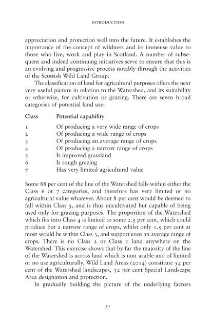
The classification <strong>of</strong> land for agricultural purposes <strong>of</strong>fers the next<br />
very useful picture in relation to the Watershed, and its suitability<br />
or otherwise, for cultivation or grazing. There are seven broad<br />
categories <strong>of</strong> potential land use:<br />
Class Potential capability<br />
1 Of producing a very wide range <strong>of</strong> crops<br />
2 Of producing a wide range <strong>of</strong> crops<br />
3 Of producing an average range <strong>of</strong> crops<br />
4 Of producing a narrow range <strong>of</strong> crops<br />
5 Is improved grassland<br />
6 Is rough grazing<br />
7 Has very limited agricultural value<br />
Some 88 per cent <strong>of</strong> the line <strong>of</strong> the Watershed falls within either the<br />
Class 6 or 7 categories, and therefore has very limited or no<br />
agricultural value whatever. About 8 per cent would be deemed to<br />
fall within Class 5, and is thus uncultivated but capable <strong>of</strong> being<br />
used only for grazing purposes. The proportion <strong>of</strong> the Watershed<br />
which fits into Class 4 is limited to some 2.5 per cent, which could<br />
produce but a narrow range <strong>of</strong> crops, whilst only 1.5 per cent at<br />
most would be within Class 3, and support even an average range <strong>of</strong><br />
crops. There is no Class 2 or Class 1 land anywhere on the<br />
Watershed. This exercise shows that <strong>by</strong> far the majority <strong>of</strong> the line<br />
<strong>of</strong> the Watershed is across land which is non-arable and <strong>of</strong> limited<br />
or no use agriculturally. Wild Land Areas (2014) constitute 54 per<br />
cent <strong>of</strong> the Watershed landscapes, 32 per cent Special Landscape<br />
Area designation and protection.<br />
In gradually building the picture <strong>of</strong> the underlying factors<br />
31