Ribbon of Wilderness by Peter Wright sampler
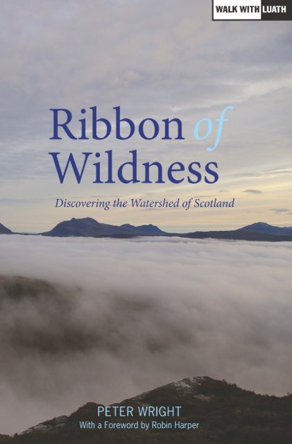
If you’ve bagged the Munros, done the Caledonian Challenge and walked the West Highland Way, this is your next conquest. The Watershed of Scotland is a line that separates east from west; that divides those river basin areas which drain towards the North Sea from those which flow west into the Atlantic Ocean on the other. It’s a line that meanders from Peel Fell on the English border all the way to the top at Duncansby Head, near John O’ Groats – over 745 miles, through almost every kind of terrain. The Watershed follows the high ground, and offers wide vistas down major river valleys, towards towns and communities, into the heartlands of Scotland. Walk the Watershed in eight weeks Tackle short sections over a weekend 7 route maps Over 30 colour photographs Ribbon of Wildness provides a vivid introduction to this geographic and landscape feature, which has hitherto been largely unknown. The rock, bog, forest, moor and mountain are all testament to the Watershed’s richly varied natural state. The evolving kaleidoscope of changing vistas, wide panoramas, ever-present wildlife, and the vagaries of the weather, are delightfully described on this great journey of discovery.
If you’ve bagged the Munros, done the Caledonian Challenge and walked the West Highland Way, this is your next conquest.
The Watershed of Scotland is a line that separates east from west; that divides those river basin areas which drain towards the North Sea from those which flow west into the Atlantic Ocean on the other. It’s a line that meanders from Peel Fell on the English border all the way to the top at Duncansby Head, near John O’ Groats – over 745 miles, through almost every kind of terrain. The Watershed follows the high ground, and offers wide vistas down major river valleys, towards towns and communities, into the heartlands of Scotland.
Walk the Watershed in eight weeks
Tackle short sections over a weekend
7 route maps
Over 30 colour photographs
Ribbon of Wildness provides a vivid introduction to this geographic and landscape feature, which has hitherto been largely unknown. The rock, bog, forest, moor and mountain are all testament to the Watershed’s richly varied natural state. The evolving kaleidoscope of changing vistas, wide panoramas, ever-present wildlife, and the vagaries of the weather, are delightfully described on this great journey of discovery.

Create successful ePaper yourself
Turn your PDF publications into a flip-book with our unique Google optimized e-Paper software.
<strong>Ribbon</strong>s <strong>of</strong> Wildness_2016_Layout 1 24/05/2016 19:26 Page 1<br />
peter wright walked the Watershed <strong>of</strong> Scotland in 2005. It took him<br />
64 days to cover the whole 1,200km, 745 miles, and he was struck <strong>by</strong><br />
how much <strong>of</strong> the route went through wild land. He started to write<br />
this book as a journal <strong>of</strong> his journey, but soon began to research and<br />
find wider evidence for his observations <strong>of</strong> the wildness. He has long<br />
been interested in Scotland’s natural environment and history, having<br />
volunteered with both the John Muir Trust, and the National Trust for<br />
Scotland. He worked for some 20 years developing the Duke <strong>of</strong><br />
Edinburgh Award in the Edinburgh area, for which he received the mbe.<br />
The National Trust for Scotland presented him with the George<br />
Waterston Memorial Award for outstanding voluntary commitment.<br />
<strong>Peter</strong> was instrumental in establ ishing The Green Team, and is now its<br />
honorary Patron.<br />
<strong>Ribbon</strong> <strong>of</strong> Wildness gives a vivid introduction to this hitherto largely<br />
unknown geographic feature.<br />
the geographer, Royal Scottish Geographical Society<br />
[<strong>Ribbon</strong> <strong>of</strong> Wildness] is something truly special and an immense<br />
celebration <strong>of</strong> the best <strong>of</strong> Scottish landscape.<br />
rory syme, John Muir Trust Journal<br />
<strong>Ribbon</strong> <strong>of</strong> Wildness will inspire others to view more than a few <strong>of</strong> the<br />
wondrous landscapes <strong>of</strong> Scotland whilst basking in their wildness.<br />
scottish wildlife magazine, Scottish Wildlife Trust<br />
A remarkable and incredible journey which others will most surely want<br />
to tackle.<br />
the hour, stv<br />
Absorbing account <strong>of</strong> a strenuous and meandering walk from Peel Fell on<br />
the Border to Duncans<strong>by</strong> Head, Caithness – all without crossing a stream.<br />
scotland in trust magazine, National Trust For Scotland<br />
John Muir would have been proud <strong>of</strong> this tremendous wild journey.<br />
Scotland’s watershed is a remarkable feature <strong>of</strong> our country, and unites<br />
wild places; both familiar and remote. This unique <strong>Ribbon</strong> <strong>of</strong> Wildness<br />
leads us on an insightful exploration <strong>of</strong> our precious wilder land and<br />
its people.<br />
j hutchison, Chairman, The John Muir Trust
<strong>Ribbon</strong>s <strong>of</strong> Wildness_2016_Layout 1 24/05/2016 19:26 Page 2<br />
By the same author:<br />
Walking with Wildness: Experiencing the Watershed <strong>of</strong> Scotland<br />
(Luath Press, 2012)<br />
Nature’s Peace: A Celebration <strong>of</strong> Scotland’s Watershed<br />
(Luath Press, 2013)
<strong>Ribbon</strong>s <strong>of</strong> Wildness_2016_Layout 1 24/05/2016 19:26 Page 3<br />
<strong>Ribbon</strong> <strong>of</strong> Wildness<br />
Discovering the Watershed<br />
<strong>of</strong> Scotland<br />
PETER WRIGHT<br />
Luath Press Limited<br />
EDINBURGH<br />
www.luath.co.uk
<strong>Ribbon</strong>s <strong>of</strong> Wildness_2016_Layout 1 24/05/2016 19:26 Page 4<br />
This book is dedicated to the memory <strong>of</strong> John Muir and<br />
the inspirational legacy he has left for us to enjoy.<br />
First published 2010<br />
Reprinted with minor changes 2011<br />
Reprinted 2012<br />
Reprinted 2013<br />
Reprinted 2014<br />
Reprinted 2015<br />
New edition 2016<br />
isbn: 978-1-910745-01-4<br />
The paper used in this book is recyclable. It is made<br />
from low chlorine pulps produced in a low energy,<br />
low emissions manner from renewable forests.<br />
Printed and bound <strong>by</strong><br />
Bell & Bain Ltd., Glasgow<br />
Maps <strong>by</strong> Jim Lewis<br />
Typeset in 10.5 point Sabon <strong>by</strong> 3btype.com<br />
The author’s right to be identified as author <strong>of</strong> this book under the<br />
Copyright, Designs and Patents Act 1988 has been asserted.<br />
© <strong>Peter</strong> <strong>Wright</strong> 2010, 2016
<strong>Ribbon</strong>s <strong>of</strong> Wildness_2016_Layout 1 24/05/2016 19:26 Page 5<br />
Contents<br />
Map 6<br />
Preface 7<br />
Foreword Robin Harper 9<br />
Acknowledgements 11<br />
chapter one Introduction 13<br />
chapter two The Reiver March 47<br />
chapter three The Laich March 84<br />
chapter four The Heartland March 125<br />
chapter five The Moine March 160<br />
chapter six The Northland March 208<br />
chapter seven Conclusion 238<br />
appendices<br />
one Munros and Corbetts on the Watershed 251<br />
two<br />
Key Areas with Conservation and<br />
Biodiversity Objectives 255<br />
three<br />
Agencies and Organisations with an<br />
Active Conservation or Biodiversity Role 259<br />
four<br />
Land Classification and Capability for<br />
Agriculture on the Watershed 264<br />
Bibliography 265<br />
Index 267<br />
5
<strong>Ribbon</strong>s <strong>of</strong> Wildness_2016_Layout 1 24/05/2016 19:26 Page 6<br />
ribbon <strong>of</strong> wildness<br />
Map <strong>of</strong> Scotland showing the Watershed, North Sea and Atlantic Ocean<br />
6
<strong>Ribbon</strong>s <strong>of</strong> Wildness_2016_Layout 1 24/05/2016 19:26 Page 7<br />
Preface<br />
<strong>Ribbon</strong> <strong>of</strong> Wildness has been well received across a broad spectrum<br />
<strong>of</strong> interests throughout Scotland and well beyond. Ever continuing<br />
sales, widespread invitations for the author to give talks and take<br />
part in events, positive reviews and comments, provide growing<br />
evidence that it has already inspired some pretty ambitious plans –<br />
and so much more; all testament to its’ popular appeal. This is all<br />
the more pleasing, given that it had not really been in my mind to<br />
write a book about it when I undertook that epic watershed walk<br />
in 2005. But the notion <strong>of</strong> a ribbon <strong>of</strong> wildness somehow emerged<br />
as I contemplated all <strong>of</strong> the landscapes I was experiencing, and as<br />
I followed a line created simply <strong>by</strong> the hand <strong>of</strong> Nature, it became<br />
evident that there really was something to write about. If the<br />
Watershed was, as I suggest, ‘the sleeping giant <strong>of</strong> the Scottish<br />
landscape’, it has most assuredly begun to be roused – or opened<br />
one eye, at least – the awakening will most assuredly continue. In<br />
time it will roar that the Watershed is one <strong>of</strong> Scotland’s greatest<br />
environmental assets.<br />
What pleases me most is <strong>of</strong> course the evidence that the<br />
Watershed is beginning to be appreciated and understood, valued,<br />
and is providing inspiration, simply for what it is – largely<br />
continuous wildness. That prevailing characteristic and quality on<br />
such an immense scale is special; unique even. <strong>Ribbon</strong> <strong>of</strong> Wildness<br />
– Discovering the Watershed <strong>of</strong> Scotland has added a truly new<br />
dimension to our understanding and potential enjoyment <strong>of</strong><br />
Scotland’s countryside – <strong>by</strong> way <strong>of</strong> this distinctive ribbon <strong>of</strong> hill,<br />
mountain, moor, bog and forest. I have no doubt that this, the sixth<br />
print-run, which contains a few necessary updates, corrections, and<br />
perhaps the occasional improvement to the text, will be widely<br />
sought and give added energy to the plans that are taking shape in<br />
many quarters.<br />
7
<strong>Ribbon</strong>s <strong>of</strong> Wildness_2016_Layout 1 24/05/2016 19:26 Page 8<br />
ribbon <strong>of</strong> wildness<br />
In the few years since I walked and then wrote about the<br />
Watershed, there has been one major and all too rapidly growing<br />
imposition on our landscapes. As I talk to people the length <strong>of</strong> the<br />
land, it is clear that there is genuine alarm at the seemingly inexo -<br />
rable spread <strong>of</strong> wind farms – especially in the more prominent<br />
locations <strong>of</strong> ridge and skyline. If I was somewhat ambivalent about<br />
the issue in the first printing <strong>of</strong> <strong>Ribbon</strong> <strong>of</strong> Wildness, I take a new<br />
stance in this one. Wind farms are a blot on the wildness <strong>of</strong> the<br />
Watershed, and should therefore be strenuously opposed on and<br />
around it. To those community groups that have the task <strong>of</strong><br />
presenting a compelling case to conserve their bit <strong>of</strong> wildness,<br />
I gladly add my voice. I very much hope that this book and all that<br />
it represents will add strength to these campaigns.<br />
The creation <strong>of</strong> designated Wild Land Areas <strong>by</strong> the Scottish<br />
Government in 2014 will hopefully do much to conserve a large<br />
part <strong>of</strong> the Watershed landscape, in that 54 per cent <strong>of</strong> the route<br />
runs right through such areas. In addition to this, some 32 per cent<br />
is within the currently growing Special Landscape Area designation.<br />
These, and a notable number <strong>of</strong> other designations, add weight to<br />
the cause for some presumption in favour <strong>of</strong> further protecting this<br />
great environmental asset.<br />
<strong>Peter</strong> <strong>Wright</strong>, 2016<br />
8
<strong>Ribbon</strong>s <strong>of</strong> Wildness_2016_Layout 1 24/05/2016 19:26 Page 9<br />
Foreword<br />
it is with the greatest <strong>of</strong> pleasure that I sat down to write a few<br />
words <strong>by</strong> way <strong>of</strong> introduction to this highly original work. <strong>Peter</strong><br />
has dedicated most <strong>of</strong> his working life to encouraging young people<br />
to get into the outdoors, not least through his huge contribution to<br />
the development <strong>of</strong> the Duke <strong>of</strong> Edinburgh’s Award in Scotland, his<br />
creation <strong>of</strong> The Green Team, and his part in the development <strong>of</strong> the<br />
John Muir Award. Ever since Rev A.E. Robertson climbed all <strong>of</strong> the<br />
238 then known mountains in Scotland over 3,000 feet, we have<br />
been more than mildly obsessed with seeing the hills as simply a<br />
challenge in themselves – an environment to be conquered.<br />
<strong>Peter</strong>’s approach is more leisurely and thoughtful, and provides<br />
a very distinctive view <strong>of</strong> a Scotland whose history, politics,<br />
geography and landscapes have been subtly shaped on either side<br />
<strong>of</strong> the windy ridges which sweep northwards all the way from the<br />
Lowlands to Caithness.<br />
To the west, the Gaels, Norsemen and the Earls <strong>of</strong> Orkney, to<br />
the east the Picts and the Britons, and to the south the Romans,<br />
Angles and Saxons; these ridges kept cultures apart and slowed the<br />
rate <strong>of</strong> assimilation in such a way that the spirit, the cultural song<br />
<strong>of</strong> these diverse interests, survives in so many ways that add to the<br />
present richness and value <strong>of</strong> our heritage.<br />
You can stride with <strong>Peter</strong> on this journey, on your own ribbon<br />
<strong>of</strong> wildness and appreciate the full richness <strong>of</strong> the landscapes that<br />
fall away on either side <strong>of</strong> it. You can experience the beauty and the<br />
contrasts between the wetter west with its lochs, woods and rocky<br />
shorelines, and the s<strong>of</strong>ter straths <strong>of</strong> the east, and reflect on how<br />
these landscapes shaped our history, psyche, and our cultures<br />
down the centuries. You will be moved; it will undoubtedly raise<br />
your spirits.<br />
9
<strong>Ribbon</strong>s <strong>of</strong> Wildness_2016_Layout 1 24/05/2016 19:26 Page 10<br />
ribbon <strong>of</strong> wildness<br />
Thank you <strong>Peter</strong> for a gentle view, your perception <strong>of</strong> our<br />
landscapes shaped <strong>by</strong> a journey, a thoughtful stroll rather than just<br />
a physical challenge; an engagement with what lies beside and<br />
behind us, as well as that which lies ahead, a truly original and<br />
three-dimensional view.<br />
Robin Harper msp, 2010<br />
8
<strong>Ribbon</strong>s <strong>of</strong> Wildness_2016_Layout 1 24/05/2016 19:26 Page 11<br />
Acknowledgements<br />
the genesis <strong>of</strong> <strong>Ribbon</strong> <strong>of</strong> Wildness lay in a long and largely solo<br />
walk, but many people – both friends and strangers – helped along<br />
the way and the whole experience was undoubtedly enriched <strong>by</strong><br />
their generous interest and support. The process <strong>of</strong> research for the<br />
book was similarly helped in no small measure <strong>by</strong> advice that was<br />
freely given, and the enthusiasm <strong>of</strong> the many people that I consulted.<br />
The list <strong>of</strong> all those who have helped would be a lengthy one, and<br />
might well run the risk <strong>of</strong> appearing as a litany <strong>of</strong> names and<br />
interests. And there would be the danger <strong>of</strong> causing <strong>of</strong>fence <strong>by</strong><br />
inadvertently omitting some who had in good faith been unstinting<br />
with their contribution. So the prudent, but no less sincere course,<br />
is to record an all-embracing ‘thank-you’, with my genuine gratitude<br />
to each and every one who played a part in shaping what appears<br />
here in this book; your help is warmly appreciated.<br />
I make one exception, though. My family has been very<br />
understanding, and shown a lot <strong>of</strong> patience, as I have become<br />
somewhat engrossed in this great interest. So I want them to know<br />
that their support is not received lightly; I am immensely grateful.<br />
11
<strong>Ribbon</strong>s <strong>of</strong> Wildness_2016_Layout 1 24/05/2016 19:26 Page 12<br />
ribbon <strong>of</strong> wildness<br />
12
<strong>Ribbon</strong>s <strong>of</strong> Wildness_2016_Layout 1 24/05/2016 19:26 Page 13<br />
chapter one<br />
Introduction<br />
the great environmentalist John Muir (1838–1914), in<br />
summing up his introduction to nature wrote, ‘When I was a boy<br />
in Scotland, I was fond <strong>of</strong> everything that was wild, and all my life<br />
I’ve been growing fonder and fonder <strong>of</strong> wild places and wild<br />
creatures’. This pithy observation will have struck a clear chord<br />
with countless people in Scotland and beyond, as it echoes down<br />
the years to the present day. For many <strong>of</strong> us it is the wild places,<br />
and their spirit <strong>of</strong> wildness, which give the defining inspirational<br />
experiences; we are at one with the immense quality and diversity<br />
<strong>of</strong> our surrounding landscapes. With Muir, we grow ever fonder <strong>of</strong><br />
Nature and her wildness.<br />
And there is delight for us in the detail as well as the grandeur<br />
– moments <strong>of</strong> pleasure to be had in coming upon a single wild<br />
flower, or the enchanting sound <strong>of</strong> the skylark on the moor, every<br />
bit as much as the bigger landscape and wide mountain vistas. We<br />
are in its thrall.<br />
Perhaps it was simply the desire to tackle a really challenging<br />
journey that prompted my interest in this venture, for having done<br />
a number <strong>of</strong> coast-to-coasts, and other such walks, I developed an<br />
appetite for more. Some <strong>of</strong> the books about long walks that I had<br />
read had prompted me to think <strong>of</strong> something ambitious <strong>of</strong> my own,<br />
and a wider passion for Scottish landscape, combined to pose a quest<br />
for the largely unknown. It was somewhere amongst this jumble <strong>of</strong><br />
tantalising imaginings, that I conceived that Scotland must have a<br />
watershed. One <strong>of</strong> the few subjects that I had any great interest in<br />
at school was geography, and that interest had lingered down the<br />
years, so the idea <strong>of</strong> a watershed (which I will expand on shortly),<br />
seemed appealing. Thus, I got the necessary research underway, and<br />
started planning for what would be a logistical challenge in itself.<br />
13
<strong>Ribbon</strong>s <strong>of</strong> Wildness_2016_Layout 1 24/05/2016 19:26 Page 14<br />
ribbon <strong>of</strong> wildness<br />
So, what started as a mental exercise, turned into a physical epic,<br />
and has become my great passion – for reasons that will most surely<br />
become evident. Writing a book about it, or more precisely, about<br />
what I discovered over 64 days <strong>of</strong> walking and my subsequent<br />
research, has all taken me down a track that I never envisaged. I<br />
had thought that simply walking it would be enough, but<br />
something even bigger, every bit as compelling and immensely<br />
enriching has grown from my challenge.<br />
It is my great privilege to share some <strong>of</strong> this experience with<br />
those who care to read <strong>Ribbon</strong> <strong>of</strong> Wildness, and to discover why I<br />
have chosen this title. They may well see Scotland, her landscapes,<br />
our interaction with them, in an entirely new light. They may just<br />
see the possibility <strong>of</strong> a new challenge, and all the delights that this<br />
could bring.<br />
To start with, we must look briefly at some <strong>of</strong> the forces and<br />
timescales that created the Scotland we know and value today.<br />
Here we find that this landform evolved like a vast three dimen -<br />
sional jigsaw puzzle, with a number <strong>of</strong> the pieces coming together<br />
having variously drifted half way across the face <strong>of</strong> the planet.<br />
Scotland is the sum <strong>of</strong> its parts, and took a great many millions <strong>of</strong><br />
years to develop. The oldest rocks here are amongst some <strong>of</strong> the<br />
most ancient on earth, at over 4,000 million years. They, along<br />
with their younger neighbours, were at times submerged under the<br />
oceans, or drifted as the sands <strong>of</strong> the hot deserts, or lay as the floor<br />
<strong>of</strong> vast swamps. They were then either thrust upwards <strong>by</strong> forces<br />
that are almost beyond comprehension, or were subjected to great<br />
heat or severe cold. They were compressed <strong>by</strong> the immense weight<br />
<strong>of</strong> overlying layers <strong>of</strong> rock, or the ice cap that lay on top, and was<br />
a mile or more deep. In places volcanic action further mixed the<br />
chronology <strong>of</strong> the different strata that make up the layers. Younger<br />
rock poured out on top <strong>of</strong> much older, with almost cataclysmic<br />
compression. The force <strong>of</strong> colliding tectonic plates caused further<br />
distortion and twisting, and in time great cracks appeared and<br />
sliced across the crust. The land on either side <strong>of</strong> these fault lines<br />
experienced further change, with the two sides moving sideways<br />
14
<strong>Ribbon</strong>s <strong>of</strong> Wildness_2016_Layout 1 24/05/2016 19:26 Page 15<br />
introduction<br />
and very slowly in opposite directions. In some locations the immense<br />
pressures involved in this distortion <strong>of</strong> the earth’s crust caused one<br />
side <strong>of</strong> the fault to over-ride the other, forcing the lower level down<br />
into the earth’s mantle, and thus creating a geological conundrum.<br />
Fire, water, movement, time, fracture and eruption are just some <strong>of</strong><br />
the direct causes <strong>of</strong> what lies beneath, but are fundamental to the<br />
landscape <strong>of</strong> Scotland we see today.<br />
That is not all, for a number <strong>of</strong> Ice-Ages, the most recent ending<br />
only 11,000 years ago, left their mark. Having ground down and<br />
removed the surface rocks, they eroded ever deeper into the crust.<br />
Thousands <strong>of</strong> metres <strong>of</strong> rock were removed in the process and then<br />
as the ice finally melted sea levels rose; as with a great sigh <strong>of</strong> relief<br />
parts <strong>of</strong> the land rose too, when the great weight <strong>of</strong> the ice, which<br />
had borne down upon it, finally disappeared. Two thirds <strong>of</strong> what<br />
became Scotland almost separated from the rest and would have<br />
Stone saga<br />
15
<strong>Ribbon</strong>s <strong>of</strong> Wildness_2016_Layout 1 24/05/2016 19:26 Page 16<br />
ribbon <strong>of</strong> wildness<br />
become another island, but the tide turned, and the shape <strong>of</strong> the<br />
land that we know and love was established.<br />
Gradually the land was colonised <strong>by</strong> plants, birds and animals<br />
which migrated northwards across the land bridge that then linked us<br />
to mainland Europe. Gradually too our landscape took on a fertile<br />
living mantle, and the round <strong>of</strong> the seasons established a perceptible<br />
pattern from year to year. But climate change – yes, there is nothing<br />
new about that – heralded colder and wetter conditions, which had<br />
a lasting impact. We can still see evidence <strong>of</strong> this today, in the large<br />
areas <strong>of</strong> peat that started to form during this period. And finally,<br />
the actions <strong>of</strong> man over the last ten or more millennia, have left<br />
their mark as we have used and abused the resources <strong>of</strong> nature at<br />
our disposal. So what we have today in our landscapes is the<br />
product <strong>of</strong> a multi-dimensional geological process, with the impact<br />
<strong>of</strong> climate changes and the lasting affects <strong>of</strong> our own efforts. James<br />
Hutton (1726–97), the founding father <strong>of</strong> much <strong>of</strong> our geological<br />
understanding, in describing geological processes saw ‘… no sign <strong>of</strong><br />
a beginning, and no sign <strong>of</strong> an end.’ A contemporary <strong>of</strong> his wrote<br />
‘… we grew giddy as we gazed into the a<strong>by</strong>ss <strong>of</strong> time.’ This helps<br />
to put our own relative insignificance on the face <strong>of</strong> the earth into<br />
some perspective, but as we shall see our actions have probably<br />
had a greater effect than our brief tenure might otherwise justify.<br />
How do we make sense <strong>of</strong> this rich tapestry – our landscape?<br />
Well, the best way to start is simple and practical, with a visit to<br />
the higher ground; for it is from some elevated vantage point that<br />
the patterns and variety <strong>of</strong> the countryside becomes clear. From the<br />
higher ground we can see the valleys, lochs, hills, moors, fields, dis -<br />
tant coast and islands unfold into wide panoramas which expand<br />
outwards to the horizon. The Watershed is on the higher ground,<br />
it is the continuous spine <strong>of</strong> Scotland, and it is from this elevation<br />
that our great country can be viewed and appreciated, in a novel<br />
and immensely revealing way. This book invites you to make a<br />
journey <strong>of</strong> discovery <strong>of</strong> much that this geographic feature has to<br />
<strong>of</strong>fer. It has been obscure until recently, but certainly now merits<br />
wider appreciation; it is a sleeping giant that begs to be woken <strong>by</strong><br />
16
<strong>Ribbon</strong>s <strong>of</strong> Wildness_2016_Layout 1 24/05/2016 19:26 Page 17<br />
introduction<br />
popular interest and involvement. And the word giant is apt, for<br />
the Watershed is on a grand scale at some 1,200 kilometres from<br />
end to end, and an average elevation <strong>of</strong> around 450 metres above<br />
sea level. It is consistently on the higher ground.<br />
It will be argued that it is a unique linear geographic feature,<br />
that its distinctive quality is that it is relatively wild, or wilder<br />
throughout – that there can be no other single entity in the physical<br />
geography <strong>of</strong> Scotland that largely maintains this character on<br />
such an epic scale. The Watershed truly is an artery <strong>of</strong> nature,<br />
which flows all the way from Peel Fell on the border with England,<br />
to distant Duncans<strong>by</strong> Head, overlooking the waters <strong>of</strong> the<br />
Pentland Firth, with the Orkney Islands beyond.<br />
The description <strong>of</strong> what the Watershed is that establishes its<br />
linear location is not complicated: any map <strong>of</strong> Scotland shows that<br />
its landform faces in two distinct directions: east towards the North<br />
Sea on the one hand, and west to the Atlantic Ocean on the other.<br />
Now imagine that you are a raindrop about to descend on<br />
Scotland: whether you end up in that Ocean or that Sea will clearly<br />
be determined <strong>by</strong> where you land, and the Watershed is the<br />
defining line. And although it is a rather rambling line, it is none<br />
the less definitive. If, as that raindrop, you land to the east <strong>of</strong> the<br />
line, then <strong>by</strong> bog, burn and river, you are bound for the North Sea,<br />
and should you land on the other side <strong>of</strong> that line, then you are<br />
westward, and Atlantic bound.<br />
This simple definition does require further examination; some<br />
explanation is called for.<br />
As recently as 6,000 years ago, before sea levels rose to their<br />
current levels, what we now call mainland Britain was physically<br />
part <strong>of</strong> Europe, with a large area <strong>of</strong> land called Doggerland filling<br />
the English Channel and the southern part <strong>of</strong> the North Sea. At the<br />
northern end <strong>of</strong> the uk, what later became the Orkney Islands<br />
formed a peninsula at the upper extremity <strong>of</strong> this very different<br />
looking landmass. But then, as now, there was a distinct body <strong>of</strong><br />
water to the east, which was to become recognised as the North<br />
Sea, and all <strong>of</strong> the water to the west <strong>of</strong> this was the Atlantic Ocean,<br />
17
<strong>Ribbon</strong>s <strong>of</strong> Wildness_2016_Layout 1 24/05/2016 19:26 Page 18<br />
ribbon <strong>of</strong> wildness<br />
or connected directly to it. Thus what we now call Scotland has,<br />
since at least the end <strong>of</strong> the last Ice-Age, had a clear east-west<br />
divide, and that line <strong>of</strong> demarcation has since extended northwards<br />
through Orkney and beyond, to the Shetland Islands. This has been<br />
critical in helping to determine the northern terminus <strong>of</strong> the Water -<br />
shed on the mainland <strong>of</strong> Scotland.<br />
Each major part <strong>of</strong> the Watershed has a distinctive geological<br />
and physical character, and the main fault-lines form the points <strong>of</strong><br />
transition from one to the other. It is largely from this that each<br />
section derives its’ particular landscape type and special qualities.<br />
There have been a small number <strong>of</strong> people who have walked<br />
versions <strong>of</strong> the Watershed, most notably Dave Hewitt. His excellent<br />
book on his trek entitled Walking the Watershed, set the northern<br />
end at Cape Wrath – the top left hand corner. Whilst his account<br />
<strong>of</strong> his journey makes an excellent read, and has a compelling<br />
narrative about what can only be described as a very demanding<br />
continuous walk, I differ on the significance <strong>of</strong> where the<br />
Watershed ends in the north. He was, I believe, enticed <strong>by</strong> the<br />
promise <strong>of</strong> including Foinaven in his journey, and hence heading<br />
towards the wilds <strong>of</strong> Cape Wrath. However, I would argue that<br />
there is only one geographically correct Watershed, and the North<br />
Sea-Atlantic Ocean divide is the simple key to it, ie, which body <strong>of</strong><br />
water it is destined for. This very clearly brings both <strong>of</strong> the island<br />
groups <strong>of</strong> Orkney and Shetland into the picture. The body <strong>of</strong> water<br />
<strong>of</strong>f the short north coast <strong>of</strong> Scotland is most certainly part <strong>of</strong> the<br />
Atlantic Ocean. Were you to stand on the western shores <strong>of</strong> either<br />
Orkney or Shetland, and remark to yourself and your companions<br />
‘next stop America’, your gaze would be across the Atlantic swell.<br />
Finally, the rocks from which both Caithness and Orkney are<br />
formed show geological continuity; these areas are part <strong>of</strong> the same<br />
structure. From all <strong>of</strong> this, it can be seen that the northern terminus<br />
<strong>of</strong> the geographic Watershed on the mainland is, as now<br />
acknowledged <strong>by</strong> the Royal Scottish Geographical Society, firmly<br />
anchored to Duncans<strong>by</strong> Head.<br />
More recently, three highly motivated individuals have further<br />
18
<strong>Ribbon</strong>s <strong>of</strong> Wildness_2016_Layout 1 24/05/2016 19:26 Page 19<br />
introduction<br />
added significantly to the full Watershed canon: Malcolm Wylie, and<br />
Chris Townsend with their respective walking ventures, and the<br />
inspirational Watershed Runners, Colin Meek, Elspeth Luke and<br />
Stuart Macfarlane.<br />
So, whilst the definition <strong>of</strong> the watershed is fairly simple, and<br />
plotting it on a map is relatively straightforward, it begs the question<br />
as to what and where are the existing geographical or cartographic<br />
references to it? The answer would appear to be that there were<br />
none; there were no contemporary maps showing the geographic<br />
Watershed in its entirety – I could find nothing definitive. Having<br />
been unable to unearth any precise references to it, I decided to do<br />
something about this gap in our available material, and this book<br />
is the result.<br />
Having defined what I meant <strong>by</strong> ‘the watershed’, and clarified<br />
its geographic credentials, I started with arguably the two most sig -<br />
nificant geographic organisations: The Royal Geographic Society<br />
and The Royal Scottish Geographical Society, and I drew a blank<br />
with both. Neither organisation could provide any reference to what<br />
I was looking for. I then wrote to a number <strong>of</strong> seemingly appropriate<br />
academics on the subject, and again drew similar blanks. I dug deep<br />
into the very comprehensive and contemporary publication Scotland<br />
– Encyclopaedia <strong>of</strong> Places and Landscapes (2005), but still the<br />
Watershed remained elusive. I visited the National Library <strong>of</strong> Scotland<br />
Map Library at Causewayside; still nothing! A good friend who is<br />
both a geographer and climber pointed me in the direction <strong>of</strong><br />
Francis Groome’s Ordnance Gazetteer <strong>of</strong> Scotland (1884), and this<br />
set the quest rolling. Here I did find an unequivocal definition <strong>of</strong> the<br />
northern end – Duncans<strong>by</strong> Head. The Bartholomew Survey Atlas<br />
<strong>of</strong> Scotland <strong>of</strong> 1912, further confirmed this.<br />
This quest had intrigued me, not least because in this day and<br />
age, when it would seem as if everything has already been weighed,<br />
measured and counted, it was strange to find something as seemingly<br />
simple as the Watershed unaccounted for. And this became even<br />
more tantalising as the watersheds <strong>of</strong> other countries and continents<br />
are both defined and well known. In the Americas, the watersheds<br />
19
<strong>Ribbon</strong>s <strong>of</strong> Wildness_2016_Layout 1 24/05/2016 19:26 Page 20<br />
ribbon <strong>of</strong> wildness<br />
<strong>of</strong> both North and South are almost celebrated, and closer to home<br />
Nicholas Crane’s wonderful book Clear Waters Rising, which is<br />
about his 10,000 kilometre journey along the watershed <strong>of</strong> main -<br />
land Europe, from Cape Finisterre to Istanbul, is popularly acclaimed.<br />
These watersheds are very much on their respective maps.<br />
It is perhaps useful at this stage to consider at what point in the<br />
development <strong>of</strong> the mapping <strong>of</strong> Scotland that the Watershed could<br />
have been plotted with any accuracy. When was it that maps had<br />
reached a sufficient degree <strong>of</strong> sophistication, with enough key<br />
information, to allow for a reasonably placed line to be drawn?<br />
In the second century ad, Ptolemy produced a map <strong>of</strong> the<br />
British Isles for the benefit <strong>of</strong> the Roman administration, and given<br />
that much <strong>of</strong> Scotland was beyond the accepted limit <strong>of</strong> both the<br />
Roman Empire and its occupation or incursion, the map was<br />
somewhat vague as to what lay beyond their frontiers. Scotland is<br />
depicted as being orientated west to east, thus lying at right angles<br />
to England. The original <strong>of</strong> this map has been lost, but a 12th or<br />
13th century copy survives. From this and other related references,<br />
a version was printed in the late 15th century. There are a number<br />
<strong>of</strong> recognisable features on this map including some <strong>of</strong> the major<br />
firths and rivers, but the layout and information is wholly<br />
insufficient to draw any watershed. Similarly, the Gough map <strong>of</strong><br />
about 1360, whilst pointing Scotland correctly on its north-south<br />
axis, and showing some features that we would recognise, <strong>of</strong>fers a<br />
confusing correlation <strong>of</strong> other features; it lacks a convincing<br />
overall shape. By 1546, Lilly had drawn a map which was getting<br />
much closer to the Scotland we know, but certain key features were<br />
either missing or still misplaced.<br />
Just 20 years later, in about 1566, two maps appeared which<br />
did <strong>of</strong>fer a much clearer picture in terms <strong>of</strong> shape, key features and<br />
their correlation to each other. An anonymous Italian map almost<br />
provides the necessary detail and in the right place, but it put the<br />
Great Glen crossing at the wrong end <strong>of</strong> Loch Lochy, and so fails<br />
the test. Lawrence Newell’s map, on the other hand, <strong>of</strong>fers a con -<br />
vincing route around and between all <strong>of</strong> the key features for plot ting<br />
20
<strong>Ribbon</strong>s <strong>of</strong> Wildness_2016_Layout 1 24/05/2016 19:26 Page 21<br />
introduction<br />
the Watershed. Critically, it locates the Orkney Islands in exactly<br />
the right place <strong>of</strong>f the far north east coast. Thus, 1566 or there -<br />
abouts is the essential date for determining the point at which map<br />
making, and the surveying techniques to go along with it, had<br />
advanced sufficiently to show most <strong>of</strong> the major rivers flowing in<br />
the correct direction, and their correlation one with the other. In<br />
theory therefore, the Watershed could have been plotted almost<br />
450 years ago.<br />
While there are a number <strong>of</strong> other maps from this period which<br />
would also serve to show that mapmaking had become much more<br />
sophisticated, it took another 100 years for an atlas to appear, which<br />
would be the defining publication. Joan Blaeu’s Atlas <strong>of</strong> 1665 pro -<br />
vides a series <strong>of</strong> maps which not only show clearly the upper reaches<br />
and pr<strong>of</strong>iles <strong>of</strong> all <strong>of</strong> the river catchments, but also some very useful<br />
information about the general locus <strong>of</strong> the Watershed. The maps<br />
would appear to have been surveyed and hence drawn from the<br />
perspective <strong>of</strong> the lower ground; the more populated areas <strong>of</strong> the<br />
river valleys. From there, they project an image <strong>of</strong> the headwater<br />
areas as sparsely populated, with very few settlements. These areas<br />
are shown in a vague manner, with the county or geographic area<br />
boundaries sweeping through a seemingly unknown terrain; through<br />
landscapes with apparently few defining features – areas <strong>of</strong> little<br />
significance. Perhaps this says more about how these areas fitted<br />
into the warp and weft <strong>of</strong> community life than anything else. At<br />
that time there were very few roads, and wherever possible, water<br />
and sea travel was still very much the norm. The higher, remoter<br />
areas were undoubtedly less well known, and indeed <strong>of</strong> lesser<br />
importance. Their relative emptiness was real; they <strong>of</strong>fered few<br />
resources that could be exploited, they were more exposed and<br />
much less fertile.<br />
The first six-inch to the mile Ordnance Survey maps do show<br />
a watershed in a number <strong>of</strong> places, notably in the far north. These<br />
are drawn in a series <strong>of</strong> generally straight lines linking specific<br />
identifiable points, and therefore have what may be described as a<br />
rather mechanistic approach to something which in reality should<br />
21
<strong>Ribbon</strong>s <strong>of</strong> Wildness_2016_Layout 1 24/05/2016 19:26 Page 22<br />
ribbon <strong>of</strong> wildness<br />
be shown as an organic flowing line; for the Watershed is just that.<br />
Those areas in which a watershed is shown are far from<br />
comprehensive, and a number <strong>of</strong> lesser watersheds between river<br />
valleys are shown. So it is fair to conclude that the intention was<br />
not to delineate and show the Watershed as a whole, but rather to<br />
include a watershed when this seemed appropriate.<br />
Part <strong>of</strong> the image <strong>of</strong> the border between Scotland and England<br />
is its troubled but colourful history. It is an area filled with the<br />
romance <strong>of</strong> stories <strong>of</strong> war and pillage, <strong>of</strong> great families constantly<br />
struggling to assert their power and control. For not only was<br />
much <strong>of</strong> this strife about the meeting <strong>of</strong> two nations frequently in<br />
dispute, but local feuds played a major part too. It is this legacy, in<br />
the form <strong>of</strong> the Border Ballads and tales that have been handed<br />
down as a celebration <strong>of</strong> great deeds, loves lost and won, truth,<br />
loyalty and despair.<br />
Indeed, the line <strong>of</strong> the border itself took a long time to become<br />
recognised and accepted, especially at the eastern end around<br />
Berwick-upon-Tweed. But the border line as we know it today was<br />
established in 1249 with the Laws <strong>of</strong> the Marches and further<br />
ratified in 1328 at the end <strong>of</strong> the 30-year Wars <strong>of</strong> Independence –<br />
with some subsequent minor adjustments, and not a little continuing<br />
political assertion, even to the present day. The word March is given<br />
to mean a boundary or frontier; and we will hear a lot more <strong>of</strong> this.<br />
In the context <strong>of</strong> the border it is used to describe three divisions or<br />
sections, along with the hinterland on either side <strong>of</strong> this border.<br />
Each <strong>of</strong> the three Marches had its own wardens, legal and<br />
organisational arrangements; each had its own distinctive<br />
mechanisms for resolving, or attempting to resolve peaceably,<br />
disputes and <strong>of</strong>fensive deeds. The three Marches were the Eastern,<br />
Middle and Western.<br />
What is it then that determines the start or southern end <strong>of</strong> the<br />
Watershed <strong>of</strong> Scotland?<br />
Firstly, a look at the English side to discover what forms the<br />
northern end <strong>of</strong> the watershed <strong>of</strong> England. The eastern side is<br />
straightforward, with the basin <strong>of</strong> the River Tyne which drains into<br />
22
<strong>Ribbon</strong>s <strong>of</strong> Wildness_2016_Layout 1 24/05/2016 19:26 Page 23<br />
introduction<br />
the North Sea below Newcastle-upon-Tyne and which comes west -<br />
wards as far as Haltwhistle on Hadrian’s Wall. But the west is less<br />
clear, as on the Western March, the border follows the Kershope<br />
Burn and the River Esk, and then jumps west to pick up the River<br />
Sark just north <strong>of</strong> Carlisle. Much <strong>of</strong> the Esk above Canonbie is in<br />
Scotland forming Eskdale, which <strong>of</strong> course rises on Eskdalemuir.<br />
South <strong>of</strong> Kershope Forest, three rivers form the northern trib -<br />
utaries <strong>of</strong> the River Eden catchment which flows through Carlisle,<br />
and thence into the Solway Firth. The Rivers Lyne, King Water and<br />
Irthing respectively form the upper reaches <strong>of</strong> the western side <strong>of</strong><br />
the watershed <strong>of</strong> England. Put simply, the River Eden and its catch -<br />
ment flow into the Solway Firth in the west, and the River Tyne and<br />
its catchment drains east into the North Sea. From this, the critical<br />
point is to discover where the divide appears on the border itself.<br />
The Middle March <strong>of</strong> the border extends some 50km south west<br />
from the Cheviot to the Kershope Burn, 5km south <strong>of</strong> Newcastleton.<br />
On the English side, the Watershed comes from the south west to<br />
Peel Fell from the Larriston Fells via Deadwater. And from Peel<br />
Fell it then runs north to Hartshorn Pike, with the Scaup Burn<br />
draining to the Kielder on the one hand, and the Peel Burn draining<br />
to the Liddel Water in Liddesdale on the other. The border is<br />
therefore not quite on a watershed line between the Kielder and the<br />
Tweed catchments in this area. But further to the north east, they<br />
merge again at Carter Bar.<br />
The summit <strong>of</strong> Peel Fell is some 50 metres or so on the English<br />
side <strong>of</strong> the border and at 602 metres is the highest point in this<br />
area. Given the drainage patterns around it, it is the logical, if not<br />
the exact, starting point for the Watershed <strong>of</strong> Scotland. The word<br />
peel has a number <strong>of</strong> recognised meanings, and in this context is<br />
seen to refer to a significant boundary – which the border most<br />
certainly is. Thus the meaning <strong>of</strong> Peel Fell can be interpreted as the<br />
boundary mountain.<br />
Throughout the last 1,000 years <strong>of</strong> history, much <strong>of</strong> the Water -<br />
shed <strong>of</strong> Scotland has been a boundary in one form or another. But<br />
it is as if it had been drawn on a map with invisible ink and needs<br />
23
<strong>Ribbon</strong>s <strong>of</strong> Wildness_2016_Layout 1 24/05/2016 19:26 Page 24<br />
ribbon <strong>of</strong> wildness<br />
some magic formula to be brushed on to make the line appear<br />
fully, for there are many different layers <strong>of</strong> traditional boundaries<br />
waiting to be revealed. In addition to this great east – west<br />
demarcation, it has been throughout history, and indeed continues<br />
to be, a variety <strong>of</strong> different boundaries or marches. A journey back<br />
through the pages <strong>of</strong> history begins to reveal its significance. Some<br />
220km <strong>of</strong> the Watershed currently forms the boundary between<br />
different Local Authority areas, and thus almost one fifth <strong>of</strong> its<br />
length has a contemporary legal status, with these boundaries<br />
having been established as recently as 1996. Prior to 1975, when<br />
the old County structure disappeared, as much as 35 per cent <strong>of</strong><br />
the Watershed was drawn as County boundary. And, since the<br />
origin <strong>of</strong> many <strong>of</strong> the counties were the earlier sherriffdoms, we see<br />
these boundaries stretch well back into medieval times.<br />
A study <strong>of</strong> Andy Wightman’s Who Owns Scotland shows that<br />
as much as 70 per cent <strong>of</strong> the Watershed still forms a boundary<br />
between different estates or other land holdings. There is a fence,<br />
or the remains <strong>of</strong> a fence-line, along almost three quarters <strong>of</strong> its<br />
length, and a drystane dyke on a number <strong>of</strong> short stretches. As a<br />
boundary, it will appear on countless title deeds as a March to<br />
many a farm, forest or shooting estate. The shepherds, foresters<br />
and keepers will know it well, but it is very much at the hinterland<br />
<strong>of</strong> the holdings that they patrol, and therefore the least utilised part<br />
<strong>of</strong> them. It is at the extremity – the wildest part.<br />
Until comparatively recent times, the Parish played a major<br />
part in people’s lives – including matters <strong>of</strong> church, education,<br />
some significant aspects <strong>of</strong> administration, and social organisation<br />
in societies and other local associations. Although there were<br />
changes over the years with a slow process <strong>of</strong> Parish divisions or<br />
amalgamations, and transfer from one pres<strong>by</strong>tery to another, the<br />
picture remained largely stable for hundreds <strong>of</strong> years. And this<br />
Parish structure, which was at the heart <strong>of</strong> local life, dated back to<br />
Mediaeval times. It was, however, a casualty <strong>of</strong> the Local Govern -<br />
ment re-organisation <strong>of</strong> the mid-70s, and the Parish boundaries<br />
were removed from the popular Ordnance Survey map series at<br />
24
<strong>Ribbon</strong>s <strong>of</strong> Wildness_2016_Layout 1 24/05/2016 19:26 Page 25<br />
introduction<br />
about the same time. The sense <strong>of</strong> local identity which this Parish<br />
structure had maintained was replaced <strong>by</strong> the new concept <strong>of</strong><br />
community, and the establishment <strong>of</strong> Community Councils. With<br />
as much as 80 per cent <strong>of</strong> the Watershed having formerly been<br />
Parish boundary, its significance to people living on either side <strong>of</strong><br />
it today continues. It now marks out the upper extent <strong>of</strong> their<br />
Community Council or school catchment area, and the area <strong>of</strong><br />
benefit for other local associations. In some places, the advent <strong>of</strong><br />
greater mobility, which the car has brought, will have had an<br />
impact on how local is indeed local, especially in the realms <strong>of</strong><br />
economic activity, but the concept <strong>of</strong> local prevails none the less.<br />
The significance <strong>of</strong> the Parish boundary was further reinforced<br />
in historical times when witches, villains and, tragically, suicides<br />
could not be buried in consecrated ground. In such cases, a kind <strong>of</strong><br />
no-mans-land on the Parish boundary was <strong>of</strong>ten chosen. How<br />
many such unmarked graves are there on the Watershed itself? No<br />
one will ever know.<br />
So, as the magic formula is painted onto the map, and the layers<br />
<strong>of</strong> demarcation, organisation and sense <strong>of</strong> place for local people do<br />
indeed begin to emerge, it is clear that all but a small proportion<br />
<strong>of</strong> the Watershed has significance as a boundary <strong>of</strong> one sort or<br />
another. And these boundaries continue to influence people’s<br />
current thinking, identity and activity, to the present day.<br />
When I finally set out to take a pencil and plot the Watershed<br />
on a map, the concept was relatively simple, for many <strong>of</strong> the factors<br />
I have described were fairly clear. The only real prerequisite was an<br />
ability to read and interpret a map, so the starting point was a<br />
paper exercise – no boots or walking poles required. The major<br />
river valleys and their tributaries were clearly marked, but there<br />
were a few areas which needed some more careful consideration,<br />
and these included:<br />
Coulter to Biggar Common<br />
Black Law wind farm to Kirk o’ Shotts transmitter<br />
Cumbernauld<br />
Carron Reservoir in the Campsie Fells<br />
25
<strong>Ribbon</strong>s <strong>of</strong> Wildness_2016_Layout 1 24/05/2016 19:26 Page 26<br />
ribbon <strong>of</strong> wildness<br />
The Great Glen crossing<br />
West end <strong>of</strong> Loch Quoich<br />
Rhidorroch in Wester Ross<br />
As these sections were finally clarified thanks to some very helpful<br />
advice from Dr Walter M Stephen, a clear line was completed on my<br />
large bundle <strong>of</strong> 24 different 1:25,000 os sheets. It was a great<br />
revelation.<br />
The Watershed has been described as lying on the higher<br />
ground, and with an average elevation <strong>of</strong> some 450m above sea<br />
level, it is indeed <strong>of</strong>ten in the clouds. The lowest point is at Laggan<br />
in the Great Glen: a mere 35m, whilst the highest point is Sgurr<br />
nan Ceathreamhnan in Kintail at 1,151m. It starts at 602m on Peel<br />
Fell, finishes at 60m above the waters <strong>of</strong> the Pentland Firth, and<br />
takes in a commendable 45 Munros (mountains over 3,000ft) along<br />
the way.<br />
It is the elevation <strong>of</strong> the Watershed that is one <strong>of</strong> its supreme<br />
qualities and makes it special. It <strong>of</strong>fers wide views to the traveller,<br />
with great panoramas across vast swathes <strong>of</strong> mainland Scotland<br />
and beyond. A journey on the Watershed presents an unfolding<br />
and evolving kaleidoscope <strong>of</strong> landscape and Nature; Scotland the<br />
Best, viewed consistently from an elevated position. And it is this<br />
which gives it a unique distinction – as a single geographic feature<br />
running the length <strong>of</strong> the land, which lays the headwaters <strong>of</strong> most<br />
<strong>of</strong> the major river catchments and systems at its feet. It is a linear<br />
vantage feature from which the eye is led outwards and down the<br />
river valleys and lochs towards the coast, thus providing a tangible<br />
geographic and visual link to many <strong>of</strong> our urban settlements and<br />
wider landscapes.<br />
The elevation <strong>of</strong> the Watershed has had another significant effect,<br />
one that generally maintains its relative wildness throughout. As<br />
our distant ancestors gradually settled and made use <strong>of</strong> the avail -<br />
able resources around them, they chose first the coasts, islands and<br />
the lower reaches <strong>of</strong> the river plains. The process <strong>of</strong> settlement then<br />
continued further upstream, and out into the wider countryside,<br />
which saw their impact on the landscape grow and expand. Forest<br />
26
<strong>Ribbon</strong>s <strong>of</strong> Wildness_2016_Layout 1 24/05/2016 19:26 Page 27<br />
introduction<br />
clearings and the emergence <strong>of</strong> basic farming, building, burial and<br />
celebration all show now as markings or shadows in the earth.<br />
And this process continued with the Roman invasion in some areas,<br />
and the seemingly empty period that followed their departure. The<br />
Church made its mark with the growth <strong>of</strong> monastic settlement and<br />
economic exploitation over wide areas, and these were in turn<br />
carved-up during the Reformation to herald the new regime. Great<br />
estates, industrialisation and an increasing urban population with<br />
its needs, all contributed to an ever-changing landscape. A myriad<br />
<strong>of</strong> other land-altering influences have all come and gone and left<br />
their mark. But throughout much <strong>of</strong> history, the higher ground had<br />
little to <strong>of</strong>fer or exploit; it was the least affected <strong>by</strong> man’s efforts.<br />
Sheep and deer grazing may have had some impact on these elevated<br />
areas, but the general impression is <strong>of</strong> wilder and untamed terrain.<br />
What then <strong>of</strong> the social and economic place <strong>of</strong> the Watershed<br />
today? In addition to its varied and only slightly diminished role as<br />
Local Government or estate boundary, the Watershed has been and<br />
continues to be a boundary in other ways. Because <strong>of</strong> the local<br />
identity which still prevails around villages and towns, the<br />
community and social organisation which this brings tends to turn<br />
its back on the higher ground; local people’s orientation is towards<br />
their own side <strong>of</strong> the Watershed, facing downstream. Without being<br />
necessarily conscious <strong>of</strong> its particular status, people’s communities<br />
<strong>of</strong> interest are demarcated in part <strong>by</strong> the Watershed.<br />
Communication plays a significant part in this, for even in this age<br />
<strong>of</strong> motor transport, there are nonetheless fewer roads and railways<br />
crossing the Water shed than there would be elsewhere further down<br />
in the river valleys. And there are no such lines <strong>of</strong> communication<br />
running along the Watershed – it is our empty quarter. If its place<br />
as a boundary <strong>of</strong> one sort or another can simply be seen as one <strong>of</strong><br />
the major causes, then the effect is its wildness.<br />
In the past, self-sufficiency in each community for its needs,<br />
including food, materials, manufacture and commerce, would have<br />
served to limit the need to transport across the Watershed; other<br />
more accessible sources and resources would have been used when<br />
27
<strong>Ribbon</strong>s <strong>of</strong> Wildness_2016_Layout 1 24/05/2016 19:26 Page 28<br />
ribbon <strong>of</strong> wildness<br />
the need arose. This is not to say that people did not cross the<br />
Watershed, as there is indeed plenty <strong>of</strong> evidence where path and<br />
track crossed, but there is no doubt that it was an inhibiting factor.<br />
Whilst the decline in local production for local use has been largely<br />
replaced <strong>by</strong> national and international markets, there remains the<br />
vestige <strong>of</strong> local influence in some <strong>of</strong> the services and the more<br />
recent drive to create local markets.<br />
That the route <strong>of</strong> the Watershed is distinctively wilder in char -<br />
acter throughout its long meander as the backbone <strong>of</strong> Scotland is<br />
hardly surprising. As a boundary, it is at the outer limit <strong>of</strong> commu -<br />
nity, Local Authority and estate, beyond the pace <strong>of</strong> everyday life<br />
and use. Its elevation puts much <strong>of</strong> it beyond, indeed well beyond,<br />
the commercial tree line. The terrain it crosses is therefore amongst<br />
the least cultivated and wildest land, but herein lies the paradox.<br />
The temptation to regard hill, mountain and moor, especially<br />
the more scenic areas, as entirely natural and unaffected <strong>by</strong> the actions<br />
<strong>of</strong> man, is a mistake. Whilst the tourist literature and romantic<br />
song may wax lyrical about the ‘bonnie purple heather’, or even<br />
make bolder statements about ‘last great wildernesses’, they would<br />
be misguided. There are very few places anywhere in Scotland that<br />
have either not been affected <strong>by</strong> human action in the past, or have<br />
retained a truly natural state. For much <strong>of</strong> Scotland was originally<br />
covered in trees, and what was subsequently called the Forest <strong>of</strong><br />
Caledon, with some form <strong>of</strong> woodland cover extending well into<br />
the mountainous areas, with the more elevated areas as patchy scrub,<br />
and only the higher summits clear <strong>of</strong> it. The start <strong>of</strong> felling to make<br />
way for early forms <strong>of</strong> farming and construction dated back to the<br />
times when we made that transition from hunter-gatherers to farmers;<br />
to the point at which we became more settled. The loss or removal<br />
<strong>of</strong> trees and the erosion <strong>of</strong> forest cover is one <strong>of</strong> the significant<br />
factors in altering the nature and appearance <strong>of</strong> the landscape and<br />
its biodiversity.<br />
Climate change some 5,000 years ago wrought further change,<br />
as cooler and wetter conditions prevailed. This period heralded the<br />
start <strong>of</strong> the formation <strong>of</strong> peat and peat-bog on a major scale in<br />
28
<strong>Ribbon</strong>s <strong>of</strong> Wildness_2016_Layout 1 24/05/2016 19:26 Page 29<br />
introduction<br />
most areas; many areas <strong>of</strong> the ancient forest succumbed to this<br />
hostile habitat, and the great tree stumps which we <strong>of</strong>ten see today,<br />
either sticking forlornly out <strong>of</strong> the side <strong>of</strong> a peat hag or standing<br />
skeletal in the heather, are <strong>of</strong>ten the legacy <strong>of</strong> that climate change.<br />
The impact <strong>of</strong> this, and the evidence it has left, can be seen in many<br />
locations on the Watershed and in the surrounding landscapes.<br />
Fast forward a few millennia then, and into the agricultural<br />
and industrial revolutions <strong>of</strong> the 18th and 19th centuries, and huge<br />
swathes <strong>of</strong> fertile land were given over to productive use. Whilst<br />
the higher more remote areas largely escaped these dramatic forms<br />
<strong>of</strong> change, they did nonetheless experience slower, but <strong>of</strong>ten equally<br />
pr<strong>of</strong>ound, alteration. Over several hundred years, sheep grazing,<br />
and an increasing deer population, and a number <strong>of</strong> natural<br />
processes have gradually eroded tree cover, including those areas<br />
which are so keenly regarded as being in their natural state. Over -<br />
grazing <strong>by</strong> both species set in a cycle <strong>of</strong> decline; young tree shoots<br />
were eaten, the woodland became singularly mature, old trees fell,<br />
and there was nothing to replace them. The inevitable outcome <strong>of</strong><br />
this process which may have taken many hundreds <strong>of</strong> years to<br />
evolve is an arboreal desert. This in turn altered the entire ecosystem,<br />
and changed everything which grew in it or sought to live on it.<br />
There are differing theories about the overall extent <strong>of</strong> wood -<br />
land loss, at what rate, and in which periods in history; and other<br />
factors have played a part too. Great loss there has been, and this<br />
has undoubtedly changed both the character and appearance <strong>of</strong> much<br />
<strong>of</strong> our landscape. It has affected the true extent <strong>of</strong> its wildness.<br />
The definition <strong>of</strong> the term ‘wild land’ and the concept <strong>of</strong> wild -<br />
ness have been given greater clarity in the Scottish Natural Heritage<br />
(snh) policy statement on Wildness in Scotland’s Country side.<br />
This <strong>of</strong>fers the useful distinction between wildness as the quality<br />
enjoyed and wild-land or places where wildness is best expressed.<br />
It expands on the importance <strong>of</strong> land use planning as the key to<br />
protecting wild land, giving Local Authorities the lead in ensuring<br />
that this is carried out effectively in their respective areas. It goes on<br />
to propose the six key attributes in the identification <strong>of</strong> wild land:<br />
29
<strong>Ribbon</strong>s <strong>of</strong> Wildness_2016_Layout 1 24/05/2016 19:26 Page 30<br />
ribbon <strong>of</strong> wildness<br />
• Its perceived naturalness.<br />
• Lack <strong>of</strong> constructions or other artefacts.<br />
• Little evidence <strong>of</strong> contemporary land uses.<br />
• Rugged or otherwise challenging terrain.<br />
• Remoteness and inaccessibility.<br />
• The extent <strong>of</strong> the area.<br />
To this should be added, the creation <strong>of</strong> the defined Wild Land<br />
Areas in 2014. Having walked the whole Watershed, my direct<br />
experience is <strong>of</strong> frequent evidence <strong>of</strong> all six <strong>of</strong> these attributes, in<br />
varying degrees and combinations, and <strong>of</strong> the very largely contin -<br />
uous wildness as the quality enjoyed.<br />
Clearly not all areas which might be accredited as being wild<br />
land would fully match all <strong>of</strong> these criteria, but this does <strong>of</strong>fer an<br />
important yardstick in helping to pin down the principal charac -<br />
teristics. The report does acknowledge too that some wild land<br />
could be ‘quite close to settlements’ – the assumption that it is to<br />
be found in only the remoter uninhabited areas is misleading. This<br />
raises the issue <strong>of</strong> fences and dykes (or their remains which may be <strong>of</strong><br />
Victorian vintage), ancient cairns, bothies, tracks, trig points, masts,<br />
pylons, and hydro-electric installations; many <strong>of</strong> these are to be<br />
found in the major wild areas. But the list <strong>of</strong> attributes <strong>of</strong> wild land<br />
provides a valuable mechanism for objectively identifying these areas.<br />
The John Muir Trust (jmt) seeks to achieve its mission ‘to<br />
conserve and protect wild areas <strong>of</strong> the uk in their natural<br />
condition, so as to leave them unimpaired for future enjoyment<br />
and study’, through its care for wild land, wildlife, education and<br />
adventure. It has done much to establish that whilst people and<br />
wild land are inseparable, their awareness and actions are critical.<br />
A further major milestone in promoting the care <strong>of</strong> the natural<br />
world and wild places in Scotland was reached in July 2005 when<br />
the concordat between snh and the jmt was signed. This was<br />
informed <strong>by</strong> the earlier snh policy on Wildness in the Scottish<br />
Countryside on the one hand, and the jmt’s Wild Land Policy <strong>of</strong><br />
2004 on the other. It is a seminal agreement between the two key<br />
players in this field; one which will serve the interests <strong>of</strong> wild land<br />
30
<strong>Ribbon</strong>s <strong>of</strong> Wildness_2016_Layout 1 24/05/2016 19:26 Page 31<br />
introduction<br />
appreciation and protection well into the future. It establishes the<br />
importance <strong>of</strong> the concept <strong>of</strong> wildness and its immense value to<br />
those who live, work and play in Scotland. A number <strong>of</strong> sub se -<br />
quent and indeed continuing initiatives serve to ensure that this is<br />
an evolving and progressive process notably through the activities<br />
<strong>of</strong> the Scottish Wild Land Group.<br />
The classification <strong>of</strong> land for agricultural purposes <strong>of</strong>fers the next<br />
very useful picture in relation to the Watershed, and its suitability<br />
or otherwise, for cultivation or grazing. There are seven broad<br />
categories <strong>of</strong> potential land use:<br />
Class Potential capability<br />
1 Of producing a very wide range <strong>of</strong> crops<br />
2 Of producing a wide range <strong>of</strong> crops<br />
3 Of producing an average range <strong>of</strong> crops<br />
4 Of producing a narrow range <strong>of</strong> crops<br />
5 Is improved grassland<br />
6 Is rough grazing<br />
7 Has very limited agricultural value<br />
Some 88 per cent <strong>of</strong> the line <strong>of</strong> the Watershed falls within either the<br />
Class 6 or 7 categories, and therefore has very limited or no<br />
agricultural value whatever. About 8 per cent would be deemed to<br />
fall within Class 5, and is thus uncultivated but capable <strong>of</strong> being<br />
used only for grazing purposes. The proportion <strong>of</strong> the Watershed<br />
which fits into Class 4 is limited to some 2.5 per cent, which could<br />
produce but a narrow range <strong>of</strong> crops, whilst only 1.5 per cent at<br />
most would be within Class 3, and support even an average range <strong>of</strong><br />
crops. There is no Class 2 or Class 1 land anywhere on the<br />
Watershed. This exercise shows that <strong>by</strong> far the majority <strong>of</strong> the line<br />
<strong>of</strong> the Watershed is across land which is non-arable and <strong>of</strong> limited<br />
or no use agriculturally. Wild Land Areas (2014) constitute 54 per<br />
cent <strong>of</strong> the Watershed landscapes, 32 per cent Special Landscape<br />
Area designation and protection.<br />
In gradually building the picture <strong>of</strong> the underlying factors<br />
31
<strong>Ribbon</strong>s <strong>of</strong> Wildness_2016_Layout 1 24/05/2016 19:26 Page 32<br />
ribbon <strong>of</strong> wildness<br />
which either serve to contribute to, or indeed define, the wilder<br />
characteristic <strong>of</strong> the Watershed, so the argument for its distinctive<br />
contribution to the geography <strong>of</strong> Scotland is expanded too. And<br />
the notion <strong>of</strong> a <strong>Ribbon</strong> <strong>of</strong> Wildness moves on from being a rather<br />
subjective observation to a case that bears much wider scrutiny.<br />
Although it is the hills and mountains that form the milestones<br />
along the Watershed, because they are the higher ground and<br />
establish the divide, it is the major rivers and their catchments that<br />
truly place the Watershed in its wider Scottish context. They describe<br />
the direction which water will take to Ocean or Sea; they are part<br />
<strong>of</strong> the bigger picture and provide the route for that watery journey.<br />
The author Neil Gunn, evocatively describes the life <strong>of</strong> a river:<br />
Going from the mouth to the source, may well seem to be<br />
reversing the natural order, to be going from the death <strong>of</strong><br />
the sea, where individuality is lost, back to the source <strong>of</strong> the<br />
stream, where individuality is born.<br />
The major rivers and their tributaries to the east <strong>of</strong> the Watershed<br />
include the Tweed, Forth, Tay, Spey, Ness, Affric, Oykel and Shin;<br />
these are all bound for the North Sea, and their combined catch -<br />
ment areas constitute a sizeable proportion <strong>of</strong> central and eastern<br />
Scotland. The major river systems on the Atlantic side include the<br />
Liddel, Esk and M<strong>of</strong>fat, which flow into the Solway Firth in the<br />
south. These are followed <strong>by</strong> the Clyde, Orchy, and Etive, and then<br />
the various shorter waters which drain into Loch Linnhe, including<br />
the Coe, Leven, Spean, Lochy and Dessary. The next rivers all typify<br />
the character <strong>of</strong> this part <strong>of</strong> the northwest Highlands, where the<br />
Watershed is well towards the western sea-board. Indeed there are<br />
short stretches in which the line <strong>of</strong> the Watershed swings even fur -<br />
ther west than some <strong>of</strong> these sea lochs’ eastward penetration. For<br />
example, Sgurr na Ciche and the remote section within the Rough<br />
Bounds, lies some 20km west <strong>of</strong> Loch Eil at Banavie, and is almost<br />
5km west <strong>of</strong> Kinloch Hourn to the north. Much <strong>of</strong> the line <strong>of</strong> the<br />
Watershed in the northwest runs parallel or close to the line <strong>of</strong> the<br />
Moine Thrust, a geological feature created when two tectonic plates<br />
collided, with the one over-riding the other – thus pushing up a long<br />
32
<strong>Ribbon</strong>s <strong>of</strong> Wildness_2016_Layout 1 24/05/2016 19:26 Page 33<br />
introduction<br />
ragged mountain formation. Moving further northwards, these short<br />
swift rivers include the Shiel, Ling, Carron, Ewe, Broom, Canaird,<br />
and Laxford, whilst the slower eastern run towards Duncans<strong>by</strong> Head<br />
includes the Strathmore, Naver, Halladale and Thurso.<br />
From this it can be seen that the place <strong>of</strong> the Watershed and its<br />
related river systems within the wider Scottish landscape is vast.<br />
Only the relatively small area to the east in Aberdeenshire and Angus,<br />
bounded <strong>by</strong> a line from near Arbroath to Carn na Fhidhleir in the<br />
southern Cairngorms, and then running north to meet the Moray<br />
coast near Portsoy, is not an integrated part <strong>of</strong> this picture. The<br />
Watershed has a defining place in the geography <strong>of</strong> all but a small<br />
proportion <strong>of</strong> the entire Scottish mainland.<br />
Land designation for wildlife, conservation, scientific or scenic<br />
purposes has seen some 25 per cent <strong>of</strong> Scotland given some form<br />
<strong>of</strong> protection in recent years. This serves to demonstrate the high<br />
quality <strong>of</strong> landscape and wildlife which we enjoy on our own door -<br />
step, and as will be seen, adds weight to the argument concerning<br />
the wilder character <strong>of</strong> the Watershed. The key forms <strong>of</strong> designation<br />
which have a direct bearing on the line <strong>of</strong> the Watershed are:<br />
Designation Abbrev Summary<br />
Sites <strong>of</strong> Special sssi Areas protected for their geological,<br />
Scientific Interest botanical or zoological importance –<br />
covering 11 per cent <strong>of</strong> Scotland.<br />
National Nature nnr Now over 70 <strong>of</strong> these areas in<br />
Reserve<br />
Scotland, in additional to smaller<br />
Local Nature Reserves.<br />
Special Areas <strong>of</strong> sac Areas cover a range <strong>of</strong> valuable non-<br />
Conservation<br />
bird habitats.<br />
Special Protection spa The conservation <strong>of</strong> wild birds is the<br />
Areas<br />
main purpose in this form <strong>of</strong> protection,<br />
with over sites 70 throughout<br />
Scotland.<br />
33
<strong>Ribbon</strong>s <strong>of</strong> Wildness_2016_Layout 1 24/05/2016 19:26 Page 34<br />
ribbon <strong>of</strong> wildness<br />
Designation Abbrev Summary<br />
National Scenic nsa An immense total, <strong>of</strong> over one million<br />
Areas<br />
hectares <strong>of</strong> Scotland are thus<br />
protected, for their visual and<br />
aesthetic qualities.<br />
Wild Land Area wla Wild land areas are the most<br />
extensive areas <strong>of</strong> high wildness. They<br />
are identified as nationally important<br />
in Scottish Planning Policy, but are<br />
not a statutory designation.<br />
Special Landscape sla A Local Government designation<br />
Area<br />
within the legislative framework.<br />
Scottish Natural Heritage is the Government agency which has<br />
general oversight <strong>of</strong> the designation processes, and <strong>of</strong> monitoring<br />
and review. The Local Authorities have a number <strong>of</strong> responsibilities<br />
in relation to these sites too, including the production <strong>of</strong> Structure<br />
Plans and the preparation <strong>of</strong> Biodiversity Action Plans. All these<br />
plans and designations serve to place the Watershed into the wider<br />
context <strong>of</strong> the surrounding areas and landscape. For the one-fifth <strong>of</strong><br />
its length that forms the boundary between different Local Authority<br />
areas, there is the need for collaboration and consultation. The<br />
relatively recent creation <strong>of</strong> the two National Parks for the<br />
Cairngorms and the Loch Lomond and Trossachs areas adds a<br />
further valuable dimension to how we care for the areas which<br />
have come under greatest pressure from the <strong>of</strong>ten conflicting<br />
interests <strong>of</strong> conservation, tourism, and the economic wellbeing <strong>of</strong><br />
the communities within their bounds. The Watershed <strong>of</strong> Scotland<br />
forms a unique link <strong>by</strong> wildness between these two National Parks.<br />
There are current recommendations for additional National Parks<br />
in ‘Unfinished Business’, and if implemented, a further 93km <strong>of</strong> the<br />
Watershed would be included.<br />
The total proportion <strong>of</strong> the Watershed that is currently designated<br />
in one way or another is 670km, or circa 54 per cent. One <strong>of</strong> the<br />
34
<strong>Ribbon</strong>s <strong>of</strong> Wildness_2016_Layout 1 24/05/2016 19:26 Page 35<br />
introduction<br />
questions which this book poses is the extent to which further pro -<br />
tection can, or should, be obtained for a greater proportion <strong>of</strong> the<br />
Watershed, given its largely wilder character and unique contribu -<br />
tion to the Scottish landscape.<br />
The case builds.<br />
A remarkable statistic about the Watershed is the small number<br />
<strong>of</strong> houses or other buildings that are located on, or immediately<br />
beside it; other than Cumbernauld’s presence, it has a particularly<br />
uninhabited air. A few stretches in the central belt are over fields,<br />
but these are represented <strong>by</strong> the less intense form <strong>of</strong> agriculture –<br />
Classes 3 and 4. About three quarters <strong>of</strong> it is or has been a fence<br />
line, and the extent to which this is aesthetically intrusive is open<br />
to debate. In places, it undoubtedly is, but in others it has served<br />
to keep activity at bay, and in fact helps to protect some habitats.<br />
The following list <strong>of</strong> manmade structures on the Watershed, or<br />
which cross it, may at first seem to adversely affect its otherwise<br />
peaceful character, but when put into the context <strong>of</strong> a line which is<br />
some 1,200 kilometres in length, it is not overbearing:<br />
Lighthouse 1 Ruined castle 1 Quarries 2<br />
Former open cast 2 Airfield 1 Houses * 21<br />
New Town 1 Reservoir 1 Masts 40<br />
Wind farms (at 2009) 2 Hydro dams 1 Ancient cairns 20<br />
‘A’ roads 24 ‘B’ roads 39 ‘U’ roads 8<br />
Dual Carriageway 0 Motorway 2 Railways 10<br />
Canals 2 Marked tracks 26 Marked footpaths 63<br />
* excluding Cumbernauld<br />
In many locations, however, habitation has receded from the<br />
Watershed, and reinforced its emptiness. The identifiable ruins or<br />
sites <strong>of</strong> around 180 houses on or adjacent to it provide the evidence<br />
for this.<br />
35
<strong>Ribbon</strong>s <strong>of</strong> Wildness_2016_Layout 1 24/05/2016 19:26 Page 36<br />
ribbon <strong>of</strong> wildness<br />
In addition to the different forms <strong>of</strong> land designation for<br />
conservation or agricultural purposes, the Watershed can be seen<br />
in its wider context, as relating to a variety <strong>of</strong> other forms <strong>of</strong> land<br />
use. There are a number <strong>of</strong> areas <strong>of</strong> commercial forest, especially<br />
in the south <strong>of</strong> Scotland. The Watershed itself has been spared<br />
from planting in this otherwise dense dark-green cloak. It remains<br />
as an unplanted strip <strong>of</strong> land, <strong>of</strong> varying width, on either side <strong>of</strong> a<br />
fence line or the remains <strong>of</strong> one; it has survived as such largely <strong>by</strong><br />
virtue <strong>of</strong> its place as a land ownership boundary. Though some<br />
private commercial forestry is now (2011) destroying this with its<br />
careless second generation planting.<br />
A number <strong>of</strong> large areas are managed to provide a clean water<br />
supply for urban areas, and in this context, land use is strictly con -<br />
trolled, and in some locations sheep farming is now being reduced<br />
or removed altogether, to be replaced <strong>by</strong> extensive native forest.<br />
The vast water catchment areas which have been given over to hydroelectric<br />
power generation, whether for national grid or aluminium<br />
smelting, have been substantially altered in the process. New reser -<br />
voirs have been created where none existed before, or natural lochs<br />
have been submerged under much larger sheets <strong>of</strong> water; these have<br />
wrought changing landscapes, some <strong>of</strong> which can be seen close to<br />
the Watershed. Whilst in a number <strong>of</strong> locations water is conveyed<br />
across the Watershed in tunnels and artificial channels to boost the<br />
supply to some distant turbine on the other side; the water pochle!<br />
Three National Trust for Scotland (nts) properties, a Royal<br />
Society for the Protection <strong>of</strong> Birds (rspb) reserve, and one Geopark<br />
all add to the variety <strong>of</strong> important landscapes and habitats that the<br />
Watershed traverses. In the M<strong>of</strong>fat Hills, the Borders Forest Trust<br />
has a considerable block <strong>of</strong> land where re-forestation is being pur -<br />
sued with enlightened vigour. The John Muir Trust is a key partner<br />
in the care and sensitive development <strong>of</strong> a number <strong>of</strong> sites. An<br />
impressive roll-call <strong>of</strong> all <strong>of</strong> the national environmental agencies<br />
completes the immense but hitherto disconnected conservation and<br />
increasing biodiversity <strong>of</strong> the Watershed – they share an expansive<br />
community <strong>of</strong> interest in this.<br />
36
<strong>Ribbon</strong>s <strong>of</strong> Wildness_2016_Layout 1 24/05/2016 19:26 Page 37<br />
introduction<br />
The hill and mountain names and their meanings give an<br />
evocative impression <strong>of</strong> how our ancestors viewed the world about<br />
them, and in particular how important these landmarks were to<br />
their lives and lore. Many <strong>of</strong> the names show close affinity with<br />
Nature, and in addition to simple colour, texture and shape, helped<br />
to establish popular description <strong>of</strong> these defining landmarks. These<br />
descriptions in turn became names which were used in charters and<br />
deeds as fixed points <strong>of</strong> reference. And with the evolution <strong>of</strong> maps,<br />
culminating in the establishment <strong>of</strong> the Ordnance Survey, these<br />
names then became <strong>of</strong>ficial. The general prominence <strong>of</strong> the Water -<br />
shed on the higher ground, and its place as a form <strong>of</strong> boundary or<br />
barrier, gave many <strong>of</strong> these hills and mountains an added signifi -<br />
cance. It is clear that our ancestors made remarkable sense <strong>of</strong> what<br />
lay around them, without the assistance <strong>of</strong> all that we can take for<br />
granted today, especially in the disciplines <strong>of</strong> land survey and carto -<br />
graphy. It is evident that in some places prominent hills had two<br />
different names conferred on them <strong>by</strong> the communities on either<br />
side – they each saw the same eminence from their own perspec -<br />
tives, and claimed it as their own. Some hill names changed over<br />
time, with the relatively more recent Ordnance Survey designations<br />
becoming the permanent labels.<br />
Rivers and burns were <strong>of</strong> particular importance, as they provided<br />
the best locations for early settlement: water supply was ready to<br />
hand, and cultivation areas near<strong>by</strong>. This held true even at the more<br />
marginal headwaters in the hills, where we <strong>of</strong>ten find the upper -<br />
most settlement is called Waterhead, or more specifically with name<br />
that refers to the river itself, such as Kelvin Head, Core Head, or Avon<br />
Head. In a number <strong>of</strong> locations the water or a geographic feature gave<br />
its name to the hill on the horizon – the hill on the Watershed, for<br />
example, Donald’s Cleuch Head, and Cauldcleuch Head.<br />
The names that the hills and mountains acquired over time give<br />
an affecting picture <strong>of</strong> our ancestors’ honest yet colourful approach<br />
to their surroundings. They didn’t have time for leisure activity as<br />
we know it, but they clearly appreciated what they saw as the dis -<br />
tinctive shapes and character <strong>of</strong> these high places. Some hills were<br />
37
<strong>Ribbon</strong>s <strong>of</strong> Wildness_2016_Layout 1 24/05/2016 19:26 Page 38<br />
ribbon <strong>of</strong> wildness<br />
associated with mythical tales and were thus established within the<br />
local lore and legends, whilst others were vested with religious<br />
significance, and had a cairn or other marker built on the summit<br />
to commemorate some long forgotten ceremony in community life.<br />
Whilst a perceived similarity to some part <strong>of</strong> the human body, both<br />
female and male, was not lost on the ancients either. A sample <strong>of</strong><br />
these tops and their meanings gives a lively impression <strong>of</strong> what our<br />
forebears saw in the landscape around them:<br />
Carlin Tooth<br />
Tomtain<br />
Stronend<br />
Beinn Chabhair<br />
Ben Lui<br />
Meall a Bhuird<br />
Sgurr Mhurlagain<br />
Sgurr na Ciche<br />
Beinn Tharsuin<br />
Sgurr nan Chaorachann<br />
Ben Hee<br />
Ben Griam Beg<br />
witch’s or old woman’s tooth<br />
hill <strong>of</strong> fire<br />
end <strong>of</strong> the nose<br />
mountain <strong>of</strong> the antler or hawk<br />
mountain <strong>of</strong> the calf<br />
hill <strong>of</strong> the roaring<br />
hill <strong>of</strong> the wool basket<br />
hill <strong>of</strong> the pap, or breast<br />
transverse hill<br />
peak <strong>of</strong> the field <strong>of</strong> the berries<br />
fairy hill<br />
small dark hill<br />
The ancient village <strong>of</strong> Cumbernauld grew up on the eastern side <strong>of</strong><br />
the Watershed and, had it not been for the establishment in the 1960s<br />
<strong>of</strong> the New Town <strong>of</strong> that name, there would have been no urban<br />
settlement whatever on our <strong>Ribbon</strong> <strong>of</strong> Wildness. There it is, ever<br />
controversial, and people either love Cumbernauld or condemn it,<br />
probably in equal measure. One <strong>of</strong> the greatest redeeming features<br />
in the design and landscaping <strong>of</strong> Cumbernauld though was the deci -<br />
sion to plant large numbers <strong>of</strong> trees, and to conserve some ancient<br />
native woodland on either side <strong>of</strong> the town. Viewed from a number<br />
<strong>of</strong> the near<strong>by</strong> vantage points, it is the greenery which effectively s<strong>of</strong>t -<br />
ens the image, and almost achieves natural continuity. Other perspec -<br />
tives are less forgiving, and it has taken careful route planning to plot<br />
the course <strong>of</strong> the Watershed through this otherwise harder landscape.<br />
38
<strong>Ribbon</strong>s <strong>of</strong> Wildness_2016_Layout 1 24/05/2016 19:26 Page 39<br />
introduction<br />
Journeys with a purpose have long been part <strong>of</strong> particular<br />
religions and cultures, with pilgrimage being the most popular<br />
amongst them; the basic idea being that some form <strong>of</strong> sustained<br />
hardship and effort will bring the individual closer to God. Such a<br />
journey will give the pilgrim time to reflect on his or her life, and<br />
resolve to be a better person in the future; having done some form<br />
<strong>of</strong> penance on the move, a higher form <strong>of</strong> grace will be achieved.<br />
But there are a number <strong>of</strong> more eco-inspired journeys and individuals<br />
that perhaps put a journey on the Watershed into a more relevant<br />
context today. John Muir embarked on a series <strong>of</strong> wilderness<br />
journeys in which he set <strong>of</strong>f with only the wild surroundings to<br />
guide him. A Thousand Mile Walk to the Gulf, and Travels in<br />
Alaska are the more notable <strong>of</strong> these, and he gives both a<br />
perceptive and inspirational account <strong>of</strong> these epic ventures that<br />
would be hard for most <strong>of</strong> us to emulate today. A number <strong>of</strong> artists<br />
have used journeys with nature to inspire their work, and created<br />
‘natural art’ as markers along the way. Richard Long and Andy<br />
Goldsworthy are perhaps amongst the better known <strong>of</strong> these, and<br />
the inspiration that they drew from the experience <strong>of</strong> a journey<br />
with nature has given both pleasure and delight to many.<br />
The scope for popular involvement has been greatly enhanced<br />
with the development <strong>of</strong> long distance routes throughout the uk and<br />
beyond, and for the thousands <strong>of</strong> people who tackle the likes <strong>of</strong> the<br />
West Highland Way each year, it is perhaps the single opportunity<br />
in which at least an element <strong>of</strong> self-reliance and significant effort<br />
in a semi-natural environment will be undertaken, so it becomes a<br />
memorable experience. The round <strong>of</strong> the Munros has taken <strong>of</strong>f as<br />
the great popular challenge, and the overall number <strong>of</strong> completions<br />
grows inexorably each year. Whilst it could be perceived that<br />
getting to the top <strong>of</strong> the hill and then back down again is <strong>of</strong>ten the<br />
sum total <strong>of</strong> the experience with Nature for some, there is perhaps<br />
no knowing what the individual gets from their surroundings with<br />
each outing. Many books have been written, and documentaries<br />
produced, about demanding journeys in summer or winter conditions,<br />
continuous and unsupported, solo or accompanied, and <strong>by</strong> people<br />
39
<strong>Ribbon</strong>s <strong>of</strong> Wildness_2016_Layout 1 24/05/2016 19:26 Page 40<br />
ribbon <strong>of</strong> wildness<br />
<strong>of</strong> all ages and abilities. Each one has been a journey with a purpose,<br />
and the opportunity for a wider public to read about it and capture<br />
even a modicum <strong>of</strong> the challenge and excitement knows no bounds.<br />
In recognising all <strong>of</strong> these possibilities and their immense<br />
potential for personal fulfilment, the author has launched the <strong>Ribbon</strong><br />
<strong>of</strong> Wildness Route – following the Watershed, in early 2016. It is<br />
described as having been ‘created <strong>by</strong> Nature alone, and as old as the<br />
hills themselves’. This book is effectively The Guide to the <strong>Ribbon</strong><br />
<strong>of</strong> Wildness Route.<br />
The new access rights to the countryside are to everyone’s<br />
advantage and have done the improbable, which was to get some<br />
measure <strong>of</strong> consensus on entitlement and good practice. The Water -<br />
shed has therefore become the next popular big walk with wildness;<br />
a unique experience with Nature, which is within the capability <strong>of</strong><br />
all who are reasonably fit and experienced. Although my initial<br />
thoughts had been that it would never catch on, and there may be<br />
a number <strong>of</strong> impracticalities, I can now see the possibilities, and<br />
will introduce these in due course. A note <strong>of</strong> caution here though:<br />
because there are a number <strong>of</strong> locations on the Watershed that are<br />
most definitely not for the novice or inexperienced, and there are<br />
a large number <strong>of</strong> fences and major bogs to be negotiated along the<br />
way! The apparent emptiness is deceptive: in reality, many people’s<br />
livelihood depends on some activity or job taking place on or about<br />
the Watershed. So a significant level <strong>of</strong> sensitivity to their needs and<br />
rights is imperative.<br />
The traditions <strong>of</strong> journeys with Nature, and the creative<br />
inspiration that this can bring, should not be underestimated.<br />
For those who in principle stick rigidly to imperial measures,<br />
<strong>Ribbon</strong> <strong>of</strong> Wildness will, in part at least, be a betrayal, because I use<br />
the metric system. The insidious process <strong>of</strong> metrication started some<br />
time back, and was imposed upon our maps well over 30 years ago,<br />
so that now all our measurements on the hill start as metres and<br />
kilometres whether we like it or not. I have, however, opted to stick<br />
with that, simply in order to maintain consistency, and to ensure that<br />
the reader will be able to match this text with their own maps.<br />
40
<strong>Ribbon</strong>s <strong>of</strong> Wildness_2016_Layout 1 24/05/2016 19:26 Page 41<br />
introduction<br />
The significant length <strong>of</strong> the Watershed and the variety <strong>of</strong><br />
terrain it passes through are just two <strong>of</strong> the factors that give this<br />
geographic feature such appeal. But they also present a challenge –<br />
how best to break it down into more manageable stretches? I have<br />
identified it in five sections which, though very different in length,<br />
have each got their particular character. They are in part determined<br />
<strong>by</strong> the geological structure <strong>of</strong> Scotland, and use some geological<br />
features as their parameters.<br />
I have chosen to approach this description <strong>of</strong> the Watershed <strong>of</strong><br />
Scotland from south to north, in part because that is the direction<br />
in which I walked and explored it, but also because its northern<br />
terminus at Duncans<strong>by</strong> Head points tantalisingly towards South<br />
Ronaldsay in the Orkney Islands, via the Pentland Skerries – now<br />
described and illustrated in detail in Nature’s Peace – a Celebration<br />
<strong>of</strong> Scotland’s Watershed, published in 2013 <strong>by</strong> Luath Press. I have<br />
described in some detail the ways and extent to which the<br />
Watershed is a boundary, and therefore adopt the most fitting<br />
word for a boundary in Scottish lore and language – a March. Each<br />
<strong>of</strong> the five Marches <strong>of</strong> the Watershed has its own distinctive terrain<br />
and place in the geography <strong>of</strong> Scotland.<br />
The Reiver March<br />
The Border Reivers were primarily <strong>of</strong> the great landholding families<br />
that occupied that area, and much <strong>of</strong> their lawless reiving or cattle<br />
rustling epitomised the times that they lived in. The Armstrongs<br />
and Scotts, Livingstones and Elliots, and many others, whose deeds<br />
<strong>of</strong> theft, pillage, murder and retribution have been handed down to<br />
us in publications like Wilson’s Tales <strong>of</strong> the Borders, in the writings<br />
<strong>of</strong> Sir Walter Scott and, most beautifully, in the Border Ballads.<br />
Starting at Peel Fell on the border with England, this first 133km<br />
<strong>of</strong> the Watershed runs at an average elevation <strong>of</strong> some 550m above<br />
sea level. It sweeps through the higher ground in both Wauchope<br />
and Craik forests, on what are aptly described as ‘the rolling border<br />
hills’. It then follows in a great S-shaped gesture round the head -<br />
41
<strong>Ribbon</strong>s <strong>of</strong> Wildness_2016_Layout 1 24/05/2016 19:26 Page 42<br />
ribbon <strong>of</strong> wildness<br />
waters <strong>of</strong> the Ettrick and then the M<strong>of</strong>fat Waters, and onto one <strong>of</strong><br />
the higher tops in the area, Hart Fell. From there it runs across the<br />
head <strong>of</strong> the Devil’s Beeftub and onto Clyde Law where the start <strong>of</strong><br />
both the Tweed and Clyde Rivers are but a few kilometres apart.<br />
Thus far its journey has been largely westward, but here it swings<br />
sharply north along more <strong>of</strong> these ‘rolling hills’, <strong>by</strong> Gathersnow<br />
Hill and Culter Fell, and finishes at the dramatic Southern Upland<br />
Fault. On Gawky Hill the land falls away steeply to the northwest;<br />
it is almost like standing on a high shoreline looking across<br />
a broad expanse <strong>of</strong> rippling loch, in hues <strong>of</strong> brown and green.<br />
The Laich March<br />
Laich or low is a very Scottish word which aptly describes much <strong>of</strong><br />
this, the second section, running for some 175km from the Southern<br />
Upland Fault line on Gawky Hill to the Highland Boundary Fault<br />
line on Guilan, to the east <strong>of</strong> Loch Lomond. The average elevation<br />
<strong>of</strong> the Laich March is 280m, which is about half that <strong>of</strong> the Reiver<br />
March. As the line meanders across this lower area, <strong>of</strong>ten referred<br />
to as the Central Belt, it appears to make a dash from hilltop to<br />
outcrop, almost avoiding the flatter and more fertile land on either<br />
side. It also seems to weave round and past nearly all <strong>of</strong> the settle -<br />
ments that are seemingly in the way. But <strong>of</strong> course the reality is the<br />
other way round, as the settlements generally developed <strong>of</strong>f the<br />
highest ground. There is only the one exception to this: Cumbernauld.<br />
From the evocatively named Gawky Hill, the line crosses to Shaw<br />
Hill, skirts Coulter, and rises to Biggar Common, Black Mount, and<br />
then touches the south Pentlands at Craigengar. Leven Seat and<br />
Black Law are followed <strong>by</strong> Kirk o’ Shotts transmitter and the m8<br />
crossing, with Black Loch and Limerigg moors coming before the<br />
urban expanse <strong>of</strong> Cumbernauld with all its trees. The Campsie Fells<br />
present another S shaped sweep as the Carron and Endrick Waters<br />
appear to push the Watershed west, east, and then back to the west<br />
again, where, at Stronend, which stands out like the bow <strong>of</strong> a great<br />
ship, it drops steeply to Balglair Muir. A final sweep past Balfron<br />
42
<strong>Ribbon</strong>s <strong>of</strong> Wildness_2016_Layout 1 24/05/2016 19:26 Page 43<br />
introduction<br />
to Moor Park then brings it to a steep ascent <strong>of</strong> the fault line and<br />
onto Guilan.<br />
The Heartland March<br />
In the third March, the Watershed ventures into what is <strong>of</strong>ten<br />
regarded as the ‘heartland <strong>of</strong> Scotland’, with a great sweep<br />
eastwards into Badenoch. At an average elevation <strong>of</strong> 610m, it is<br />
the highest <strong>of</strong> the Marches, and at 240km, it is the second longest.<br />
It starts <strong>by</strong> heading north over Ben Lomond to Beinn a Chroin,<br />
past Crianlarich and on to Ben Lui. Dropping down past the old<br />
mines to pass Tyndrum and almost as far as Loch Lyon before<br />
ascending to Beinn Achaladair, it crosses the railway at the head <strong>of</strong><br />
the Water <strong>of</strong> Tulla. A majestic circumnavigation <strong>of</strong> Rannoch Moor<br />
follows with the heights above it at Black Mount, before crossing<br />
to A Chruach. Swinging back across the railway at the snow tunnel<br />
between Rannoch and Corrour stations it progresses northeast via<br />
Ben Alder to Feagour near the head <strong>of</strong> Loch Laggan. Running west -<br />
wards again, it crosses Carn Liath, and is briefly overshadowed <strong>by</strong><br />
Creag Meagaidh before slipping between the sources <strong>of</strong> the River<br />
Spey on the one hand and the Roy on the other. And the final<br />
stretch looks down benignly on the Corrieyairack Pass before<br />
dropping steeply through the forest into the Great Glen at Laggan.<br />
The Moine March<br />
For mountaineers and those who love remoteness, this March has<br />
everything to <strong>of</strong>fer. The 330km stretch reaches an average elevation<br />
<strong>of</strong> 595m, and much <strong>of</strong> it runs in close parallel to the line <strong>of</strong> the Moine<br />
Thrust. This is a geological feature, a fault line running close to<br />
much <strong>of</strong> the north-west coast, which has had a major impact upon<br />
the landscape <strong>of</strong> that part <strong>of</strong> Scotland.<br />
The steep climb out <strong>of</strong> the great trench that the Great Glen Fault<br />
created is rewarded with fine views up Loch Ness, and down<br />
towards Ben Nevis. From Ben Tee the Watershed then makes a<br />
43
<strong>Ribbon</strong>s <strong>of</strong> Wildness_2016_Layout 1 24/05/2016 19:26 Page 44<br />
ribbon <strong>of</strong> wildness<br />
swoop westwards past Loch Arkaig and Glen Dessary into the area<br />
known as the Rough Bounds. On Sgurr na Ciche it turns<br />
northwards over a roll-call <strong>of</strong> the great peaks, including those on<br />
south Glenshiel ridge – Beinn Fhada, Stuc Mor, Sgurr Chaorachain<br />
and Moruisg, before dropping down close to Achnasheen. A<br />
circuitous route takes it to the Fannichs – <strong>by</strong> the loch first, and<br />
then to the fine group <strong>of</strong> mountains which are presided over <strong>by</strong><br />
Sgurr Mor. Across the Dirrie More at Loch Droma, and north via<br />
Beinn Dearg, it leads on to Seana Bhraigh and into a vast emptiness<br />
<strong>of</strong> Rhidorroch Forest and the Cromalt Hills to the head <strong>of</strong> Strath<br />
Oykel. The magnificent wildness <strong>of</strong> Inchnadamph Forest takes in<br />
Breabag, Conival and Beinn Leoid, with the steep drop through<br />
rough woodland to the pass between lochs More and Merkland.<br />
And, with a final flourish, it takes in a great horseshoe over Carn<br />
Dearg and onto Ben Hee.<br />
The Northland March<br />
The Vikings came this way and left their mark in the place names,<br />
the Clearances came too and left the glens largely empty <strong>of</strong> people,<br />
and the wealthy from elsewhere sought a tax-break in the alien<br />
forests they planted. Neil Gunn celebrated the landscape in his<br />
writing though, and told us <strong>of</strong> the wide skies and light which this<br />
northland boasts. Whilst not the shortest <strong>of</strong> the Marches, at 180km,<br />
its average elevation <strong>of</strong> just 240m brings it down gently to the final<br />
headland, with its vistas across the Pentland Firth.<br />
The descent from Ben Hee onto the moors at the start <strong>of</strong> the<br />
Flow Country is steep and ragged; a last rocky encounter. There are<br />
fewer landmark hills here, though the scattered peaks make a bold<br />
statement in an otherwise flatter landscape. Some large peat bogs<br />
dotted with lochans take the Watershed on a southward line past<br />
Loch Fiag to Crask and its lonely but hospitable inn. Eastwards from<br />
there, it trails through Ben Armine Forest, which like so many such<br />
forests is more for deer than trees, and round above Loch Choire,<br />
to Truderscraig, with its many archaeological sites. Ben Griam Beg<br />
44
<strong>Ribbon</strong>s <strong>of</strong> Wildness_2016_Layout 1 24/05/2016 19:26 Page 45<br />
introduction<br />
looks down over a large area <strong>of</strong> the Flow Country which the rspb has<br />
taken into its enlightened custody. The Knockfinn Heights follow,<br />
and then almost 30km <strong>of</strong> blanket bog with Ben Alisky barely rising<br />
above the heather before the a9 is reached just north <strong>of</strong> Latheron.<br />
A meander across the flat lands <strong>of</strong> Caithness <strong>by</strong> Spittal, Bower and<br />
Slickly follows, and the end is almost in sight, with the last 5km<br />
along the cliff tops leading to Duncans<strong>by</strong> Head itself.<br />
<strong>Ribbon</strong> <strong>of</strong> Wildness is <strong>of</strong>fered as an introductory guide to the<br />
Watershed <strong>of</strong> Scotland, and also to the <strong>Ribbon</strong> <strong>of</strong> Wildness Route,<br />
with the identification <strong>of</strong> its place in the landscape and in history,<br />
and its unbridled value to us today. It teases out some <strong>of</strong> its<br />
characteristics, both simple and subtle, and maps out the many ways<br />
in which its wilder nature contributes so much to the wider Scottish<br />
landscape and, potentially, our understanding <strong>of</strong> it. This book poses<br />
many questions too, some <strong>of</strong> which are addressed within these pages,<br />
and some will come out <strong>of</strong> the response to <strong>Ribbon</strong> <strong>of</strong> Wildness,<br />
whilst others will find resolution at a highly personal level for each<br />
reader who treads lightly. The potential spiritual dimension to every<br />
encounter with wildness is both individual and unmistakeable.<br />
There is much in the way <strong>of</strong> both interest and incident to pull<br />
together and record for the first time; this book is a celebration <strong>of</strong><br />
that diversity. In adding the whole <strong>of</strong> this major geographic feature<br />
and its highly distinctive character to the Gazetteer <strong>of</strong> Scotland, it<br />
will set out a process for popular involvement in building up a<br />
comprehensive body <strong>of</strong> knowledge about its largely continuous<br />
wildness; and the unique contribution it should make to the lives<br />
<strong>of</strong> the people <strong>of</strong> Scotland and our visitors.<br />
The following chapters invite you to make a journey for your -<br />
self, one which will certainly be novel, hopefully will be filled with<br />
interest and enjoyment, and resonate with the sights and sounds <strong>of</strong><br />
all that is best in our remoter countryside.<br />
One frustration is that distances to be walked along the<br />
Watershed, and indeed the exact length <strong>of</strong> it, are hard to calculate<br />
with precision. The line is <strong>of</strong> course organic, as it flows with the<br />
45
<strong>Ribbon</strong>s <strong>of</strong> Wildness_2016_Layout 1 24/05/2016 19:26 Page 46<br />
ribbon <strong>of</strong> wildness<br />
natural shapes <strong>of</strong> hill and hollow. There are many places too, in<br />
which the water is unable to make up its mind which way to drain,<br />
so bog-land, some <strong>of</strong> it very wet indeed, is the result – making it<br />
necessary to detour away from the line, before returning to it once<br />
more. The serious wetlands <strong>of</strong> flow, occasional almost unclimbable<br />
crags, and the particular challenges <strong>of</strong> recent tree felling, all add to<br />
the need for sensible compromise. Hence, even a gps-recorded<br />
distance may prove to be out <strong>by</strong> some margin, when the Route is<br />
followed <strong>by</strong> someone else at another time. We are to some extent at<br />
its mercy, but it is no less rewarding for all that.The image <strong>of</strong> a man<br />
in his late 50s, with a well packed rucsac on his back, map in hand,<br />
and a great deal <strong>of</strong> enthusiasm in his heart, is an appealing one.<br />
And so I made my way across a border moor on a January<br />
morning, having been seen safely on my way <strong>by</strong> Charles and Sue,<br />
and Dawn and Gavin respectively. Just before the summit which is<br />
the start, I was enthralled <strong>by</strong> the appearance <strong>of</strong> a broken spectre<br />
round my own shadow, cast on the moor in front <strong>of</strong> me. A delight -<br />
fully positive portent <strong>of</strong> many good things to come.<br />
46
<strong>Ribbon</strong>s <strong>of</strong> Wildness_2016_Layout 1 24/05/2016 19:26 Page 47<br />
the reiver march<br />
47
<strong>Ribbon</strong>s <strong>of</strong> Wildness_2016_Layout 1 24/05/2016 19:26 Page 280<br />
Luath Press Limited<br />
committed to publishing well written books worth reading<br />
luath press takes its name from Robert Burns, whose little collie Luath (Gael.,<br />
swift or nimble) tripped up Jean Armour at a wedding and gave him the chance to<br />
speak to the woman who was to be his wife and the abiding love <strong>of</strong> his<br />
life. Burns called one <strong>of</strong> ‘The Twa Dogs’ Luath after Cuchullin’s<br />
hunting dog in Ossian’s Fingal. Luath Press was established<br />
in 1981 in the heart <strong>of</strong> Burns country, and now resides<br />
a few steps up the road from Burns’ first lodgings on<br />
Edinburgh’s Royal Mile.<br />
Luath <strong>of</strong>fers you distinctive writing with a hint <strong>of</strong><br />
unexpected pleasures.<br />
Most bookshops in the uk, the us, Canada, Australia,<br />
New Zealand and parts <strong>of</strong> Europe either carry our books<br />
in stock or can order them for you. To order direct from<br />
us, please send a £sterling cheque, postal order, international<br />
money order or your credit card details (number, address <strong>of</strong><br />
cardholder and expiry date) to us at the address below. Please add<br />
post and packing as follows: uk – £1.00 per delivery address;<br />
overseas surface mail – £2.50 per delivery address; overseas<br />
airmail – £3.50 for the first book to each delivery address, plus £1.00 for each<br />
additional book <strong>by</strong> airmail to the same address. If your order is a gift, we will happily<br />
enclose your card or message at no extra charge.<br />
Luath Press Limited<br />
543/2 Castlehill<br />
The Royal Mile<br />
Edinburgh EH1 2ND<br />
Scotland<br />
Telephone: 0131 225 4326 (24 hours)<br />
email: sales@luath.co.uk<br />
Website: www.luath.co.uk<br />
ILLUSTRATION: IAN KELLAS