Ribbon of Wilderness by Peter Wright sampler
If you’ve bagged the Munros, done the Caledonian Challenge and walked the West Highland Way, this is your next conquest. The Watershed of Scotland is a line that separates east from west; that divides those river basin areas which drain towards the North Sea from those which flow west into the Atlantic Ocean on the other. It’s a line that meanders from Peel Fell on the English border all the way to the top at Duncansby Head, near John O’ Groats – over 745 miles, through almost every kind of terrain. The Watershed follows the high ground, and offers wide vistas down major river valleys, towards towns and communities, into the heartlands of Scotland. Walk the Watershed in eight weeks Tackle short sections over a weekend 7 route maps Over 30 colour photographs Ribbon of Wildness provides a vivid introduction to this geographic and landscape feature, which has hitherto been largely unknown. The rock, bog, forest, moor and mountain are all testament to the Watershed’s richly varied natural state. The evolving kaleidoscope of changing vistas, wide panoramas, ever-present wildlife, and the vagaries of the weather, are delightfully described on this great journey of discovery.
If you’ve bagged the Munros, done the Caledonian Challenge and walked the West Highland Way, this is your next conquest.
The Watershed of Scotland is a line that separates east from west; that divides those river basin areas which drain towards the North Sea from those which flow west into the Atlantic Ocean on the other. It’s a line that meanders from Peel Fell on the English border all the way to the top at Duncansby Head, near John O’ Groats – over 745 miles, through almost every kind of terrain. The Watershed follows the high ground, and offers wide vistas down major river valleys, towards towns and communities, into the heartlands of Scotland.
Walk the Watershed in eight weeks
Tackle short sections over a weekend
7 route maps
Over 30 colour photographs
Ribbon of Wildness provides a vivid introduction to this geographic and landscape feature, which has hitherto been largely unknown. The rock, bog, forest, moor and mountain are all testament to the Watershed’s richly varied natural state. The evolving kaleidoscope of changing vistas, wide panoramas, ever-present wildlife, and the vagaries of the weather, are delightfully described on this great journey of discovery.

Create successful ePaper yourself
Turn your PDF publications into a flip-book with our unique Google optimized e-Paper software.
<strong>Ribbon</strong>s <strong>of</strong> Wildness_2016_Layout 1 24/05/2016 19:26 Page 35<br />
introduction<br />
questions which this book poses is the extent to which further pro -<br />
tection can, or should, be obtained for a greater proportion <strong>of</strong> the<br />
Watershed, given its largely wilder character and unique contribu -<br />
tion to the Scottish landscape.<br />
The case builds.<br />
A remarkable statistic about the Watershed is the small number<br />
<strong>of</strong> houses or other buildings that are located on, or immediately<br />
beside it; other than Cumbernauld’s presence, it has a particularly<br />
uninhabited air. A few stretches in the central belt are over fields,<br />
but these are represented <strong>by</strong> the less intense form <strong>of</strong> agriculture –<br />
Classes 3 and 4. About three quarters <strong>of</strong> it is or has been a fence<br />
line, and the extent to which this is aesthetically intrusive is open<br />
to debate. In places, it undoubtedly is, but in others it has served<br />
to keep activity at bay, and in fact helps to protect some habitats.<br />
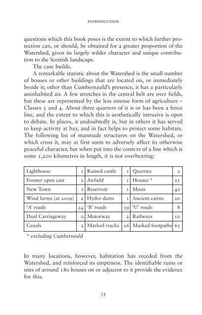
The following list <strong>of</strong> manmade structures on the Watershed, or<br />
which cross it, may at first seem to adversely affect its otherwise<br />
peaceful character, but when put into the context <strong>of</strong> a line which is<br />
some 1,200 kilometres in length, it is not overbearing:<br />
Lighthouse 1 Ruined castle 1 Quarries 2<br />
Former open cast 2 Airfield 1 Houses * 21<br />
New Town 1 Reservoir 1 Masts 40<br />
Wind farms (at 2009) 2 Hydro dams 1 Ancient cairns 20<br />
‘A’ roads 24 ‘B’ roads 39 ‘U’ roads 8<br />
Dual Carriageway 0 Motorway 2 Railways 10<br />
Canals 2 Marked tracks 26 Marked footpaths 63<br />
* excluding Cumbernauld<br />
In many locations, however, habitation has receded from the<br />
Watershed, and reinforced its emptiness. The identifiable ruins or<br />
sites <strong>of</strong> around 180 houses on or adjacent to it provide the evidence<br />
for this.<br />
35