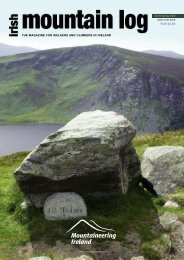
Walk Northern Ireland - Mountaineering Ireland
Walk Northern Ireland - Mountaineering Ireland
Walk Northern Ireland - Mountaineering Ireland

You also want an ePaper? Increase the reach of your titles
YUMPU automatically turns print PDFs into web optimized ePapers that Google loves.
mining. After passing through the<br />
old quarry, the route comes to<br />
Cranny Falls Nature Reserve which<br />
includes a hazel wood.<br />
Conditions become damper as<br />
you get closer to the waterfall,<br />
creating ideal conditions for<br />
dragonflies, irises and ferns. At the<br />
head of the dark ravine you are<br />
rewarded for your effort by the falls<br />
themselves, which cascade<br />
spectacularly over the dark rock<br />
above.<br />
Cranny Falls F2<br />
Starting Point: The Harbour in Carnlough<br />
village<br />
Distance: 4.8km<br />
Maps & Books: ‘Larne Country <strong>Walk</strong>’<br />
pack of 10 walks. OSNI sheet: 9<br />
Facilities: Parking: 2 car parks in<br />
Carnlough: Havelock Place and Croft<br />
Road. Toilets: Havelock Place Car Park<br />
Cladagh Glen Most visitors<br />
to <strong>Northern</strong><br />
<strong>Ireland</strong> feel<br />
their trip is<br />
not complete<br />
without a<br />
visit to the<br />
Marble Arch<br />
Caves in<br />
County<br />
Fermanagh.<br />
Yet many<br />
miss out of<br />
one of the<br />
best parts of<br />
the<br />
experience. The connoisseur’s way<br />
to visit these spectacular caves is to<br />
start at the bottom of Cladagh<br />
Glen and walk up the Cladagh<br />
River to Marble Arch Visitor<br />
Centre at the top. You can then<br />
take a tour of the caves before<br />
returning back down the glen; a<br />
perfect way to experience the<br />
ecology of this karst landscape from<br />
both above and below the ground.<br />
Cladagh Glen is a National<br />
Nature Reserve that protects a<br />
long-established ash woodland and<br />
its natural inhabitants, which<br />
include feral goats, red squirrels<br />
and pine martens. About 500m<br />
along the path you’ll see a waterfall<br />
The<br />
connoisseur’s<br />
way to visit<br />
these<br />
spectacular<br />
showcaves is<br />
to start at the<br />
bottom of<br />
Cladagh Glen<br />
and walk up<br />
the Cladagh<br />
River<br />
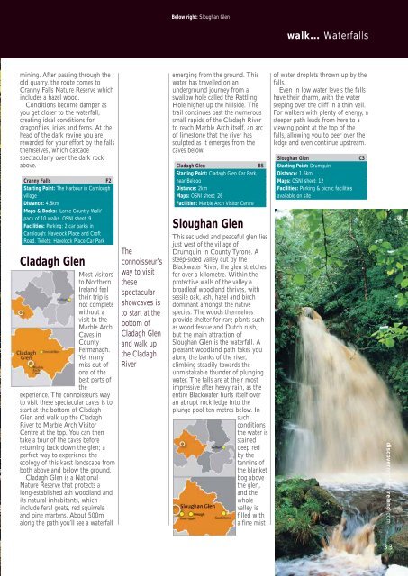
Below right: Sloughan Glen<br />
emerging from the ground. This<br />
water has travelled on an<br />
underground journey from a<br />
swallow hole called the Rattling<br />
Hole higher up the hillside. The<br />
trail continues past the numerous<br />
small rapids of the Cladagh River<br />
to reach Marble Arch itself, an arc<br />
of limestone that the river has<br />
sculpted as it emerges from the<br />
caves below.<br />
Cladagh Glen B5<br />
Starting Point: Cladagh Glen Car Park,<br />
near Belcoo<br />
Distance: 2km<br />
Maps: OSNI sheet: 26<br />
Facilities: Marble Arch Visitor Centre<br />
Sloughan Glen<br />
This secluded and peaceful glen lies<br />
just west of the village of<br />
Drumquin in County Tyrone. A<br />
steep-sided valley cut by the<br />
Blackwater River, the glen stretches<br />
for over a kilometre. Within the<br />
protective walls of the valley a<br />
broadleaf woodland thrives, with<br />
sessile oak, ash, hazel and birch<br />
dominant amongst the native<br />
species. The woods themselves<br />
provide shelter for rare plants such<br />
as wood fescue and Dutch rush,<br />
but the main attraction of<br />
Sloughan Glen is the waterfall. A<br />
pleasant woodland path takes you<br />
along the banks of the river,<br />
climbing steadily towards the<br />
unmistakable thunder of plunging<br />
water. The falls are at their most<br />
impressive after heavy rain, as the<br />
entire Blackwater hurls itself over<br />
an abrupt rock ledge into the<br />
plunge pool ten metres below. In<br />
such<br />
conditions<br />
the water is<br />
stained<br />
deep red<br />
by the<br />
tannins of<br />
the blanket<br />
bog above<br />
the glen,<br />
and the<br />
whole<br />
valley is<br />
filled with<br />
a fine mist<br />
walk… Waterfalls<br />
of water droplets thrown up by the<br />
falls.<br />
Even in low water levels the falls<br />
have their charm, with the water<br />
seeping over the cliff in a thin veil.<br />
For walkers with plenty of energy, a<br />
steeper path leads from here to a<br />
viewing point at the top of the<br />
falls, allowing you to peer over the<br />
ledge and even continue upstream.<br />
Sloughan Glen C3<br />
Starting Point: Drumquin<br />
Distance: 1.6km<br />
Maps: OSNI sheet: 12<br />
Facilities: Parking & picnic facilities<br />
available on site<br />
discovernorthernireland.com<br />
33