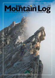
Walk Northern Ireland - Mountaineering Ireland
Walk Northern Ireland - Mountaineering Ireland
Walk Northern Ireland - Mountaineering Ireland

Create successful ePaper yourself
Turn your PDF publications into a flip-book with our unique Google optimized e-Paper software.
Above left: Moneypenny’s Lock, Portadown<br />
Above right: Mouth of Newry Canal, looking toward<br />
Warrenpoint and the Mournes<br />
canal in the British Isles.<br />
The canal was officially opened<br />
in 1742, and it thrived for over 150<br />
years. Wooden horse-drawn barges<br />
made up the bulk of the traffic.<br />
Alongside the barges were dredgers<br />
engaged in both the commercial<br />
extraction of sand from Lough<br />
Neagh, and helping to keep the<br />
waterway free of silt.<br />
Almost every town and village<br />
along the route was shaped by the<br />
canal trade. Portadown, the start of<br />
the trail thrived during the canal<br />
era, and linen mills, a brewery and<br />
distillery sprang up thanks to the<br />
volume of passing coal, timber and<br />
grain.<br />
A short distance outside<br />
Portadown the path brings you to<br />
the Point of Whitecoat, where the<br />
Rivers Bann and Cusher merge.<br />
Cross the canal here and continue<br />
along the gravel towpath to<br />
Monneypenny Lock. The adjacent<br />
lock-keeper’s house dates from the<br />
early 1800s and now contains a<br />
small museum.<br />
The placid waters of the canal<br />
offer a perfect habitat for waterloving<br />
fauna and flora. Since the<br />
closure of the navigation channel in<br />
1947, the waterway has been<br />
preserved as a haven for wildlife.<br />
Floating plants include water lilies,<br />
Canadian pondweed and<br />
walk… Newry Canal<br />
amphibious bistort. You’ll also see<br />
yellow flag iris and purple<br />
loosestrife in the early summer.<br />
Water birds are regular companions<br />
too, with ducks, swans and herons<br />
all feeding off the plethora of small<br />
insects and fish that abound in the<br />
area.<br />
John Wesley, founder of<br />
Methodism, stayed at the<br />
Terryhoogan Lock House in the<br />
mid eighteenth century and was so<br />
impressed he remained a vocal<br />
advocate of the canal. In the<br />
village of Scarva, you might be<br />
tempted to take a break in the<br />
visitor centre café. Scarva owes its<br />
very existence to the canal. A<br />
Bridge was constructed here in<br />
1744, and the settlement soon<br />
sprang up. Acton Lake, also known<br />
as Lough Shark was enlarged<br />
during the construction period, and<br />
a sluice was added to ensure<br />
consistent water levels in the canal.<br />
This marks the halfway point of<br />
the walk.<br />
Poyntzpass boomed at the time<br />
of the canal, but was not as hard<br />
hit by the canal’s subsequent<br />
closure. The development of the<br />
railway which saw the demise of<br />
the canal was ironically built<br />
adjacent to the course of the old<br />
canal. Today the train station lies<br />
just a short distance from an old<br />
canal lock, which still stands some<br />
250 years after it was constructed.<br />
As you get closer to Newry the<br />
landscape changes as you draw near<br />
to the Mournes. Beside the trail<br />
you’ll notice Canal Wood, part of<br />
the Millennium Woodland Scheme,<br />
which aims to restore <strong>Ireland</strong>’s<br />
native forests. Just a few more locks<br />
now separate you from Newry and<br />
the Canal Quay Bridge, at the<br />
official end of the route.<br />
The Newry Canal E4–E5<br />
Starting Point: Portadown<br />
Distance: 32km<br />
Maps & Books: ‘Newry Canal Way:<br />
An illustrated guide to walking the Newry<br />
Canal Way’<br />
OSNI sheet: 20/29<br />
www.waymarkedways.com<br />
Facilities: Toilets: Public houses en route<br />
discovernorthernireland.com<br />
45