Walk Northern Ireland - Mountaineering Ireland
Walk Northern Ireland - Mountaineering Ireland
Walk Northern Ireland - Mountaineering Ireland

You also want an ePaper? Increase the reach of your titles
YUMPU automatically turns print PDFs into web optimized ePapers that Google loves.
eing rather boggy underfoot. If<br />
possible, try to wait for dry<br />
conditions before attempting the<br />
walk.<br />
Most people allow two days for<br />
the route, though it’s not unknown<br />
for very fit walkers to complete the<br />
distance in a single outing. This is<br />
not recommended however unless<br />
you’re very sure of your stamina<br />
levels. If you split the walk in two<br />
you’ll probably want to stop for the<br />
night in one of the more remote<br />
valleys mid-way along the path.<br />
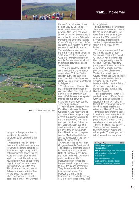
The picturesque harbour town of<br />
Ballycastle provides a fitting start<br />
for the route. The castle from<br />
which the town got its name lies<br />
beside the church on the Diamond,<br />
Above: The Antrim Coast and Glens<br />
the town’s central square. It was<br />
built in 1612 by Sir Randal<br />
MacDonnell, a member of the<br />
powerful MacDonell clan which<br />
arrived by sea from Scotland in the<br />
early sixteenth century. Ballycastle<br />
marks the spot where the Atlantic<br />
Ocean officially meets the Irish Sea<br />
and is the place to catch the ferry if<br />
you want to visit Rathlin Island.<br />
The gap between island and<br />
mainland became world famous in<br />
1898 when the Italian inventor<br />
Guiglielmo Marconi successfully<br />
sent the first ever commercial radio<br />
transmission between Ballycastle<br />
and Rathlin.<br />
The Moyle Way leaves Ballycastle<br />
along the route of the old narrow<br />
gauge railway. This line finally<br />
closed in 1950. The path then<br />
diverts into Ballycastle Forest and<br />
climbs along a series of forest tracks<br />
to Ballyveely.<br />
The steep cone of Knocklayd is<br />
the second highest mountain in<br />
Antrim at 514m. This peak enjoyed<br />
a brief moment of fame in 1788<br />
when a Dublin newspaper reported<br />
that the top had blown off,<br />
discharging molten rock over the<br />
surrounding landscape.<br />
The route continues south from<br />
Knocklayd and enters the Breen<br />
Oakwood Nature Reserve and up<br />
the slopes of Bohilbreaga. A steep<br />
descent then brings you down to<br />
the Glenshesk River, and a very<br />
pretty section of trail follows the<br />
river upstream. Look out for a<br />
small waterfall and pool, and an<br />
old gravestone on the opposite<br />
bank. This stone marks the place<br />
where a MacQuillan chief died<br />
after being defeated at the bloody<br />
Battle of Orra in 1559.<br />
After a brief trip up Altahillion<br />
Gorge you leave the forest behind.<br />
The slopes of Slieveanorra can now<br />
be seen rising ahead, where the<br />
Battle of Orra took place during<br />
the sixteenth century. During this<br />
particular skirmish, the<br />
MacDonnell clan covered the<br />
boggy mountain slope with rushes<br />
to make the ground appear solid.<br />
They then goaded their enemies<br />
into crossing the area. The<br />
MacQuillans and O’Neills<br />
floundered into the chest-deep bog,<br />
only to be slaughtered as they tried<br />
walk… Moyle Way<br />
to struggle free.<br />
Fortunately today a gravel track<br />
allows modern walkers to traverse<br />
the bog without difficulty. Fine<br />
views reward your effort as you<br />
arrive at the 508m summit of<br />
Slieveanorra. The outline of<br />
Scotland’s highlands and island<br />
should also be visible on the<br />
horizon.<br />
The route descends south from<br />
the summit, passing through<br />
Slieveanorra Forest at the base of<br />
Glendun. A wooden footbridge<br />
then brings you safely across the<br />
Glendun River. You must now<br />
gather yourself for the final climb<br />
of the route. A rough, moorland<br />
path climbs over the shoulder of<br />
Trostan, the highest peak in<br />
County Antrim at 550m. The cairn<br />
at the summit was built by the<br />
victorious members of the<br />
MacDonnell clan after the Battle of<br />
Orra. It was intended as a<br />
memorial to their leader, Sorely<br />
Boy MacDonnell.<br />
The descent from Trostan takes<br />
you back into a coniferous forest,<br />
where you pick up the line of the<br />
Essathohan Burn. A final stroll<br />
through the trees brings you to the<br />
end of the route opposite the<br />
entrance to Glenariff Forest Park.<br />
If you still have energy to spare,<br />
it’s well worth continuing into this<br />
forest park. The Glenariff River<br />
passes through the trees, creating<br />
countless spectacular waterfalls.<br />
If not, then relax, you deserve it.<br />
You have just spent two days<br />
traversing Antrim’s highest and<br />
wildest peaks. The least you can do<br />
is treat yourself to a cup of tea!<br />
The Moyle Way E2–F2<br />
Starting Point: Ballycastle<br />
Distance: 32km<br />
Maps & Books: ‘Moyle Way: An illustrated<br />
guide to walking the Moyle Way’<br />
OSNI sheet 5/9<br />
www.waymarkedways.com<br />
Facilities: Parking available. Toilets:<br />
Available at Ballycastle and Glenariff<br />
discovernorthernireland.com<br />
41