Basem Ahmed Zoheir_Barramiya, OGR_2011.pdf
Basem Ahmed Zoheir_Barramiya, OGR_2011.pdf
Basem Ahmed Zoheir_Barramiya, OGR_2011.pdf

Create successful ePaper yourself
Turn your PDF publications into a flip-book with our unique Google optimized e-Paper software.
102 B. <strong>Zoheir</strong>, B. Lehmann / Ore Geology Reviews 39 (2011) 101–115<br />
Basyuni, 1968 and references therein). The worked orebodies were<br />
mainly sulfide-bearing quartz and quartz–carbonate lodes associated<br />
with listvenite exposures, showing signs of structural control expressed<br />
in preferable orientation and consistent meso- and microfabrics.<br />
In the present study, field work, mineralogical investigations, fluid<br />
inclusions and stable isotope studies are aimed at better understand of<br />
the genesis of the <strong>Barramiya</strong> gold deposit in relation to listvenite. We<br />
also focus on the structural control of the mineralization and<br />
conditions of gold deposition.<br />
2. Geologic and structural settings<br />
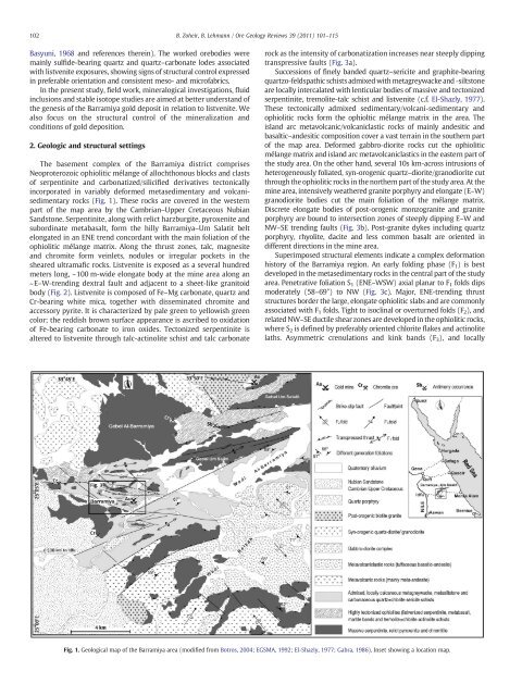
The basement complex of the <strong>Barramiya</strong> district comprises<br />
Neoproterozoic ophiolitic mélange of allochthonous blocks and clasts<br />
of serpentinite and carbonatized/silicified derivatives tectonically<br />
incorporated in variably deformed metasedimentary and volcanisedimentary<br />
rocks (Fig. 1). These rocks are covered in the western<br />
part of the map area by the Cambrian–Upper Cretaceous Nubian<br />
Sandstone. Serpentinite, along with relict harzburgite, pyroxenite and<br />
subordinate metabasalt, form the hilly <strong>Barramiya</strong>–Um Salatit belt<br />
elongated in an ENE trend concordant with the main foliation of the<br />
ophiolitic mélange matrix. Along the thrust zones, talc, magnesite<br />
and chromite form veinlets, nodules or irregular pockets in the<br />
sheared ultramafic rocks. Listvenite is exposed as a several hundred<br />
meters long, ~100 m-wide elongate body at the mine area along an<br />
~E–W-trending dextral fault and adjacent to a sheet-like granitoid<br />
body (Fig. 2). Listvenite is composed of Fe–Mg carbonate, quartz and<br />
Cr-bearing white mica, together with disseminated chromite and<br />
accessory pyrite. It is characterized by pale green to yellowish green<br />
color; the reddish brown surface appearance is ascribed to oxidation<br />
of Fe-bearing carbonate to iron oxides. Tectonized serpentinite is<br />
altered to listvenite through talc-actinolite schist and talc carbonate<br />
rock as the intensity of carbonatization increases near steeply dipping<br />
transpressive faults (Fig. 3a).<br />
Successions of finely banded quartz–sericite and graphite-bearing<br />
quartzo-feldspathic schists admixed with metagreywacke and -siltstone<br />
are locally intercalated with lenticular bodies of massive and tectonized<br />
serpentinite, tremolite-talc schist and listvenite (c.f. El-Shazly, 1977).<br />
These tectonically admixed sedimentary/volcani-sedimentary and<br />
ophiolitic rocks form the ophioltic mélange matrix in the area. The<br />
island arc metavolcanic/volcaniclastic rocks of mainly andesitic and<br />
basaltic–andesitic composition cover a vast terrain in the southern part<br />
of the map area. Deformed gabbro-diorite rocks cut the ophiolitic<br />
mélange matrix and island arc metavolcaniclastics in the eastern part of<br />
the study area. On the other hand, several 10s km-across intrusions of<br />
heterogeneously foliated, syn-orogenic quartz–diorite/granodiorite cut<br />
through the ophiolitic rocks in the northern part of the study area. At the<br />
mine area, intensively weathered granite porphyry and elongate (E–W)<br />
granodiorite bodies cut the main foliation of the mélange matrix.<br />
Discrete elongate bodies of post-orogenic monzogranite and granite<br />
porphyry are bound to intersection zones of steeply dipping E–W and<br />
NW–SE trending faults (Fig. 3b). Post-granite dykes including quartz<br />
porphyry, rhyolite, dacite and less common basalt are oriented in<br />
different directions in the mine area.<br />
Superimposed structural elements indicate a complex deformation<br />
history of the <strong>Barramiya</strong> region. An early folding phase (F1) isbest<br />
developed in the metasedimentary rocks in the central part of the study<br />
area. Penetrative foliation S1 (ENE–WSW) axial planar to F1 folds dips<br />
moderately (58–69°) to NW (Fig. 3c). Major, ENE-trending thrust<br />
structures border the large, elongate ophiolitic slabs and are commonly<br />
associated with F 1 folds. Tight to isoclinal or overturned folds (F 2), and<br />
related NW–SE ductile shear zones are developed in the ophiolitic rocks,<br />
where S 2 is defined by preferably oriented chlorite flakes and actinolite<br />
laths. Asymmetric crenulations and kink bands (F3), and locally<br />
Fig. 1. Geological map of the <strong>Barramiya</strong> area (modified from Botros, 2004; EGSMA, 1992; El-Shazly, 1977; Gabra, 1986). Inset showing a location map.