Cultus Lake Traffic and Transportation Study - Fraser Valley ...
Cultus Lake Traffic and Transportation Study - Fraser Valley ...
Cultus Lake Traffic and Transportation Study - Fraser Valley ...

You also want an ePaper? Increase the reach of your titles
YUMPU automatically turns print PDFs into web optimized ePapers that Google loves.
A Report To:<br />
For:<br />
<strong>Cultus</strong> <strong>Lake</strong><br />
<strong>Traffic</strong> <strong>and</strong> <strong>Transportation</strong> <strong>Study</strong><br />
Prepared By:<br />
JULY 2012<br />
SW1193SWA
TABLE OF CONTENTS<br />
CULTUS LAKE TRAFFIC AND TRANSPORTATION STUDY<br />
1.0 INTRODUCTION .............................................................................................. 1<br />
2.0 BACKGROUND................................................................................................ 4<br />
3.0 EXISTING CONDITIONS ................................................................................. 5<br />
3.1 Existing Demographic <strong>and</strong> Development Data ........................................ 5<br />
3.2 Existing Roadway Geometry <strong>and</strong> Operational Conditions ...................... 8<br />
3.3 Existing <strong>Traffic</strong> Data ............................................................................... 10<br />
3.4 Existing Safety Data .............................................................................. 20<br />
4.0 FORECAST CONDITIONS ............................................................................ 26<br />
4.1 Demographic <strong>and</strong> Development Forecasts ........................................... 26<br />
4.2 Forecast <strong>Traffic</strong> Generation ................................................................... 27<br />
4.3 Forecast Roadway Operations .............................................................. 30<br />
5.0 STAKEHOLDER CONSULTATION ............................................................... 31<br />
6.0 PROBLEM DEFINITION ................................................................................ 34<br />
7.0 OPTION GENERATION AND ANALYSIS ..................................................... 36<br />
8.0 EVALUATION CRITERIA .............................................................................. 51<br />
9.0 OPTION EVALUATION .................................................................................. 54<br />
10.0 PREFERRED MITIGATION STRATEGY AND SENSITIVITY REVIEW ....... 75<br />
10.1 Preferred Mitigation Strategy ............................................................... 75<br />
10.2 Sensitivity Review ................................................................................ 76<br />
11.0 FINDINGS AND RECOMMENDATIONS ....................................................... 81<br />
SW1193SWA – July 2012 i
1.0 INTRODUCTION<br />
CULTUS LAKE TRAFFIC AND TRANSPORTATION STUDY<br />
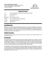
The <strong>Fraser</strong> <strong>Valley</strong> Regional District (FVRD)’s <strong>Cultus</strong> <strong>Lake</strong> area features an isolated<br />
natural setting making it a popular destination particularly during summer weekends. It<br />
is also home to local year round residents <strong>and</strong> businesses who require safe <strong>and</strong><br />
secure daily transportation. The sole continuous connection to <strong>and</strong> from the area<br />
(which includes <strong>Cultus</strong> <strong>Lake</strong>, Lindell Beach, <strong>and</strong> Columbia <strong>Valley</strong>) is via the two-lane,<br />
undivided Columbia <strong>Valley</strong> Highway.<br />
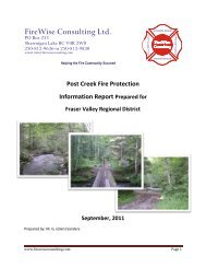
Figure 1 shows the Columbia <strong>Valley</strong> Highway <strong>and</strong> <strong>Cultus</strong> <strong>Lake</strong> area in its area<br />
context.<br />
The area known as Electoral Area “E” has grown substantially since the 1970s (more<br />
than doubling in size) <strong>and</strong> in the past three censuses, growth has stabilized at 6%<br />
over the last ten years, although there remain numerous parcels which could be<br />
developed as residential or resort-oriented housing. In light of the built form <strong>and</strong> travel<br />
characteristics of the community <strong>and</strong> the expected continuation of growth, a number<br />
of issues have come to light regarding the transportation system serving <strong>Cultus</strong> <strong>Lake</strong>.<br />
These key issues may be described as follows:<br />
� Road capacity - is it sufficient to h<strong>and</strong>le existing peak <strong>and</strong> off-peak dem<strong>and</strong>?<br />
� Road safety – are there issues related to the roadway geometry or vehicle<br />
operation along Columbia <strong>Valley</strong> Highway?<br />
� Emergency access – does congestion constrain emergency response <strong>and</strong><br />
would a secondary access alleviate delays?<br />
� Forecast development – how will future growth in the area increase traffic<br />
volumes <strong>and</strong> exacerbate the issues noted above?<br />
In order to address these issues, the FVRD retained Delcan to complete a traffic <strong>and</strong><br />
transportation study focusing on Columbia <strong>Valley</strong> Road. The study is divided into the<br />
following sub sections, with the first six sections presenting the problem definition<br />
report:<br />
� Section 2.0 provides a study background;<br />
� Section 3.0 documents existing traffic <strong>and</strong> safety conditions based on<br />
available data <strong>and</strong> observations;<br />
� Section 4.0 discusses forecast future development <strong>and</strong> the associated<br />
potential traffic impacts;<br />
� Section 5.0 provides a summary of discussions with stakeholders in the area;<br />
<strong>and</strong><br />
� Section 6.0 defines the problematic issues that will require mitigation.<br />
SW1193SWA – July 2012 1
CULTUS LAKE TRAFFIC AND TRANSPORTATION STUDY<br />
The remaining sections identify <strong>and</strong> evaluate possible options resulting in a<br />
recommended mitigation strategy:<br />
� Section 7.0 generates options to address the issues;<br />
� Section 8.0 applies evaluation criteria to select a preferred option;<br />
� Section 9.0 evaluates the options <strong>and</strong> identifies a preferred solution;<br />
� Section 10.0 describes the preferred mitigation strategy including a phasing<br />
plan;<br />
� Section 11.0 summarizes study findings <strong>and</strong> recommendations.<br />
SW1193SWA – July 2012 2
Q:\SW\1193 - FVRD <strong>Cultus</strong> <strong>Lake</strong> <strong>Study</strong>\SWA\Dwgs\Corel<br />
Columbia <strong>Valley</strong><br />
Highway 1<br />
Columbia <strong>Valley</strong> Highway<br />
Vedder Mountain<br />
<strong>Cultus</strong> <strong>Lake</strong> South /<br />
Lindell Beach<br />
Vedder Mountain Road<br />
<strong>Cultus</strong> <strong>Lake</strong><br />
<strong>Cultus</strong> <strong>Lake</strong><br />
Canada / USA Border<br />
Vedder Road<br />
<strong>Cultus</strong> <strong>Lake</strong><br />
Provincial Park<br />
(BC Parks)<br />
Yale Road<br />
Chilliwack<br />
Soowahlie IR<br />
East <strong>Cultus</strong> <strong>Lake</strong> /<br />
Sleepy Hollow<br />
Figure 1: Area Context
2.0 BACKGROUND<br />
CULTUS LAKE TRAFFIC AND TRANSPORTATION STUDY<br />
The <strong>Cultus</strong> <strong>Lake</strong> area is an exceedingly popular destination for outdoor recreation.<br />
Access to water, cottages <strong>and</strong> camping / hiking activities generate high volumes of<br />
traffic particularly on warm summer weekends <strong>and</strong> long weekends. Along the<br />
Columbia <strong>Valley</strong> Highway (the lone two-lane connection with Greater Vancouver <strong>and</strong><br />
the <strong>Fraser</strong> <strong>Valley</strong>), there is a Provincial Park, waterslides, golf courses, watercraft<br />
rentals, a marina, restaurants, stables, stores <strong>and</strong> gas stations.<br />
During peak times, lengthy queues can be observed along Columbia <strong>Valley</strong> Highway,<br />
<strong>and</strong> in recent years, the City of Chilliwack has provided temporary flagging services to<br />
assist with traffic flow at the Columbia <strong>Valley</strong> Road / Vedder Mountain Road<br />
signalized intersection.<br />
Mountainous terrain to the east <strong>and</strong> west <strong>and</strong> the US Border to the south limit options<br />
for alternate routes. In the event of a major traffic collision, natural disaster, or other<br />
disruption, the area would potentially be cut off. <strong>Traffic</strong> congestion can also impact<br />
emergency response times, <strong>and</strong> access especially during peak summer season<br />
period.<br />
The FVRD is currently undertaking an Official Community Plan (OCP) Update for<br />
Electoral Area “E”, which includes the <strong>Cultus</strong> <strong>Lake</strong> area. As part of the OCP update, a<br />
focused local area policy is being developed for the <strong>Cultus</strong> <strong>Lake</strong> South (Lindell Beach<br />
area). The subject traffic <strong>and</strong> transportation study findings will be an important input to<br />
this planning document.<br />
The subject study area is on Columbia <strong>Valley</strong> Road between Chittenden Road <strong>and</strong><br />
Frosst Creek Bridge, an approximately 12 km section.<br />
SW1193SWA – July 2012 4
3.0 EXISTING CONDITIONS<br />
CULTUS LAKE TRAFFIC AND TRANSPORTATION STUDY<br />
Existing conditions may be described in terms of existing demographics <strong>and</strong><br />
established development, as well as the operational <strong>and</strong> geometric conditions along<br />
the study area roadway.<br />
3.1 Existing Demographic <strong>and</strong> Development Data<br />
Development data was obtained from the FVRD for the study area <strong>and</strong> other<br />
upstream / downstream locations which may contribute to traffic on Columbia <strong>Valley</strong><br />
Road.<br />
These areas may be broken down as follows:<br />
SOOWAHLIE INDIAN RESERVE AND CITY OF CHILLIWACK<br />
This area includes 67 dwelling units on the Soowahlie IR, 78 residential lots within the<br />
City of Chilliwack jurisdiction <strong>and</strong> an aggregate pit operated by Kirkness Pacific.<br />
CULTUS LAKE PARKS BOARD AREA<br />
This area includes 478 residential lots, 1 church, the main beach picnic area, <strong>and</strong> 348<br />
campsites at Sunnyside Boulevard (operated by the Parks Board). Community<br />
buildings are also present in this area including the <strong>Cultus</strong> <strong>Lake</strong> Community School<br />
(accessed via Sunnyside Boulevard), the <strong>Cultus</strong> <strong>Lake</strong> Fire Department <strong>and</strong> an<br />
equipment shed.<br />
<strong>Cultus</strong> <strong>Lake</strong>’s commercial <strong>and</strong> entertainment centre is also located in this area.<br />
Commercial services include an Esso gas station, an 18 hole golf club, an 18 hole<br />
adventure golf course, two amusement parks (Funl<strong>and</strong> <strong>and</strong> <strong>Cultus</strong> <strong>Lake</strong><br />
Amusements), the recently exp<strong>and</strong>ed <strong>Cultus</strong> <strong>Lake</strong> waterslide park, <strong>and</strong> an 11,761 ft 2<br />
shopping plaza containing a variety of restaurants <strong>and</strong> services.<br />
EAST CULTUS LAKE AND SLEEPY HOLLOW AREA<br />
This area includes 172 mobile home units, 97 single family dwelling units, a<br />
neighbourhood store <strong>and</strong> pub, as well as the former <strong>Lake</strong>side Marina.<br />
SW1193SWA – July 2012 5
BC PARKS AREA<br />
CULTUS LAKE TRAFFIC AND TRANSPORTATION STUDY<br />
The total <strong>Cultus</strong> <strong>Lake</strong> Provincial Park area is 2,561 hectares (6,328 acres) <strong>and</strong><br />
includes hiking trails, beach access <strong>and</strong> picnic / camping areas. There are<br />
330 campsites with capacities as follows:<br />
� Westside – 30 sites<br />
� Entrance Bay – 52 sites<br />
� Delta Grove – 57 sites<br />
� Clear Creek – 85 sites<br />
� Honeymoon Bay – 2 sites for up to 45 people<br />
� Maple Bay – 104 sites<br />
COLUMBIA VALLEY AREA<br />
This area borders the United States <strong>and</strong> includes 11 properties owned by the<br />
Department of National Defense, 135 residences, <strong>and</strong> 41 farming or vacant lots.<br />
CULTUS LAKE SOUTH<br />
This area includes Lindell Beach <strong>and</strong> numerous recreational <strong>and</strong> camping sites. A<br />
total of 169 dwelling units are in the area, along with 350 recreational homes, <strong>and</strong> 440<br />
recreational vehicle / campsites.<br />
Table 1 summarizes the existing development data. The Institute of <strong>Transportation</strong><br />
Engineers (ITE) l<strong>and</strong> use classification code is provided for the most analogous<br />
available l<strong>and</strong> use.<br />
As shown, there is a significant amount of traffic generation potential within the <strong>Cultus</strong><br />
<strong>Lake</strong> area. There is a high ratio of recreational type development to local community<br />
development which results in a very high peak traffic generation to baseline traffic<br />
generation ratio.<br />
SW1193SWA – July 2012 6
Table 1: Existing Development Data<br />
CULTUS LAKE TRAFFIC AND TRANSPORTATION STUDY<br />
ID Area L<strong>and</strong> Use Existing Development<br />
Independent Variable Units<br />
Soowahlie IR & City of Chilliwack<br />
0 Soowahlie IR 67 dwellings, 187 population 67 single family dwelling units (ITE l<strong>and</strong> use 210)<br />
1City of Chilliwack L<strong>and</strong>s 78 residential lots, 1 vacant lot 78 single family dwelling units<br />
2Kirkness Pacific Aggregate pit<br />
<strong>Cultus</strong> <strong>Lake</strong> Parks Board Area<br />
1Private Homes 80 residential lots 80 single family dwelling units<br />
2Residential Neighbourhood<br />
3Main Beach Picnic Area<br />
398 residential lots<br />
1 church<br />
398 single family dwelling units<br />
4Commercial / Activity Area <strong>Cultus</strong> <strong>Lake</strong> Parks Board Office n/a<br />
<strong>Cultus</strong> <strong>Lake</strong> Esso 5,344.70 ft2 convenience market with gas pumps (ITE l<strong>and</strong> use 853)<br />
Giggle Ridge Adventure Golf 18 holes golf course (ITE l<strong>and</strong> use 430)<br />
<strong>Cultus</strong> <strong>Lake</strong> Golf Club 18 holes golf course (ITE l<strong>and</strong> use 430)<br />
<strong>Cultus</strong> <strong>Lake</strong> Amusements 0.3735 acre amusement park (ITE l<strong>and</strong> use 480)<br />
Manos Steakhouse<br />
J Beethoven's Pizza<br />
Café Vanilla<br />
Quirky Bird Café<br />
The New Orient Restaurant<br />
Sora Sushi & Teriyaki<br />
<strong>Cultus</strong> <strong>Lake</strong> Suprette Grocery Store<br />
The New York Corned Beef Connection<br />
5,594.50 ft2 quality restaurant (ITE l<strong>and</strong> use 931)<br />
<strong>Cultus</strong> <strong>Lake</strong> Post Office 11,761 ft2 shopping centre (ITE l<strong>and</strong> use 820)<br />
Funl<strong>and</strong> 0.9689 acre amusement park (ITE l<strong>and</strong> use 480)<br />
5<strong>Cultus</strong> <strong>Lake</strong> Water Park 14.21 acres<br />
6Community Buildings <strong>Cultus</strong> <strong>Lake</strong> Community School<br />
<strong>Cultus</strong> <strong>Lake</strong> Fire Department<br />
Equipment Shed<br />
7 Sunnyside Campground<br />
East <strong>Cultus</strong> <strong>Lake</strong> & Sleepy Hollow Area<br />
348 Sites operated by Parks Board 348 campsites (ITE l<strong>and</strong> use 416)<br />
1Mobile Home Parks 117 lots <strong>Cultus</strong> <strong>Lake</strong> Village 117 dwelling units (ITE l<strong>and</strong> use 240)<br />
30 lots Liumchen Village 30 dwelling units<br />
25 lots <strong>Cultus</strong> <strong>Lake</strong> Estates 25 dwelling units<br />
2Residential Neighbourhood<br />
3 Vacant lot<br />
18 residential lots<br />
6 vacant lots<br />
18 single family dwelling units<br />
4Residential Neighbourhood 79 residential lots<br />
3 vacant lots<br />
1 water distribution system<br />
1 neighbourhood store<br />
1 old service station<br />
1 neighbourhood pub<br />
79 single family dwelling units<br />
5Marina / Vacant lot<br />
BC Parks Area<br />
<strong>Lake</strong>side Marina<br />
0Total Park Area 2,561 ha = 6,328 acres 6328 acres (ITE L<strong>and</strong> Use 413)<br />
1Westside group campsite<br />
2Entrance Bay Picnic Area<br />
30 spaces 30 campsites<br />
Entrance Bay Campground<br />
3Spring Bay Picnic Area<br />
52 sites 52 campsites<br />
4Delta Grove Campground 57 sites 57 campsites<br />
5Clear Creek Campground 85 sites 85 campsites<br />
6Honeymoon Bay Group Sites<br />
7Maple Bay Picnic Area<br />
2 sites x 45 people 2 campsites<br />
Maple Bay Campground<br />
Columbia <strong>Valley</strong> Area<br />
104 sites 104 campsites<br />
DND 11 properties<br />
Privately Owned (Majority ALR)<br />
<strong>Cultus</strong> <strong>Lake</strong> South<br />
135 residential lots<br />
41 farming/vacant lots<br />
135 single family dwelling units<br />
1 Lindell Beach 140 single family lots 140 single family dwelling units<br />
2Spring Creek 20 single family lots 20 single family dwelling units<br />
3Aquadel 1 lot used as golf course<br />
4 Lindell Beach Holiday Resort 136 recreational sites 136 recreational homes (ITE L<strong>and</strong> Use 260)<br />
5The Cottages 214 holiday homes 214 recreational homes<br />
6Creekside 1 agricultural lot<br />
7Thous<strong>and</strong> Trails 164 RV/campsites 164 campsites<br />
8Leisure <strong>Valley</strong> 49 RV sites 49 campsites<br />
9Timmerman 1 lot<br />
10 Rural Properties 6 agricultural lots 6 single family dwelling units<br />
11 Hillside Properties 2 lots 2 single family dwelling units<br />
12 Cottages Phase 2 1 lot 1 single family dwelling units<br />
13 <strong>Cultus</strong> <strong>Lake</strong> Holiday Park 227 RV sites 227 campsites<br />
SW1193SWA – July 2012 7
CULTUS LAKE TRAFFIC AND TRANSPORTATION STUDY<br />
3.2 Existing Roadway Geometry <strong>and</strong> Operational Conditions<br />
Columbia <strong>Valley</strong> Highway is a two-lane undivided rural highway. The posted speed<br />
ranges from 30 km/h to 50 km/h <strong>and</strong> numerous advisory speed tabs are posted on<br />
horizontal curves.<br />
The corridor may be divided into four key segments:<br />
1 – FROM VEDDER MOUNTAIN ROAD TO LAKESHORE DRIVE<br />
This section is posted at 50 km/h <strong>and</strong> features relatively limited access points as it<br />
passes alongside the Soowahlie Indian Reserve. An approximate 1.0 m shoulder is<br />
available along most of the section. The intersection at Chittenden Road has been<br />
upgraded to serve development with a southbound to eastbound left-turn bay.<br />
2 – FROM LAKESHORE DRIVE TO EDMESTON ROAD<br />
This section features numerous access points to/from the primary <strong>Cultus</strong> <strong>Lake</strong> Park<br />
Board recreational activity areas. Included in the commercial services are a shopping /<br />
retail plaza, a waterpark, a mini-golf <strong>and</strong> formal golf course, <strong>and</strong> a service station.<br />
At the intersection of Sunnyside Road <strong>and</strong> Columbia <strong>Valley</strong> Highway, a modern single<br />
lane roundabout has been constructed to align with the main access of the exp<strong>and</strong>ed<br />
<strong>Cultus</strong> <strong>Lake</strong> Waterpark, a major peak season traffic generator.<br />
Due to peak season pedestrian volumes, a marked crosswalk is in place south of the<br />
Sunnyside Road intersection. There are no formal pedestrian facilities, however, <strong>and</strong><br />
pedestrians <strong>and</strong> cyclists share the available shoulder (generally less than 1.0 m).<br />
3 – FROM EDMESTON ROAD TO LINDELL AVENUE<br />
This section falls within the <strong>Cultus</strong> <strong>Lake</strong> Provincial Park <strong>and</strong> includes accesses to /<br />
from campground areas. There is no or limited shoulder provided <strong>and</strong> 30 km/h speed<br />
zone is in place near the main park entrance area.<br />
4 – FROM LINDELL AVENUE TO FROSST CREEK<br />
This section retains a 50 km/h speed limit with limited to no shoulders provided.<br />
Access to Lindell Beach <strong>and</strong> numerous recreational properties are provided in this<br />
section.<br />
Figure 2 shows each of the road segments in their area context.<br />
SW1193SWA – July 2012 8
Q:\SW\1193 - FVRD <strong>Cultus</strong> <strong>Lake</strong> <strong>Study</strong>\SWA\Dwgs\Corel<br />
Vedder Mountain<br />
Frosst Creek<br />
4<br />
Lindell Avenue<br />
Vedder Mountain Road<br />
<strong>Lake</strong>shore Drive<br />
<strong>Cultus</strong> <strong>Lake</strong><br />
3<br />
1<br />
Figure 2: Roadway Segmentation<br />
2<br />
Edmeston Road
3.3 Existing <strong>Traffic</strong> Data<br />
CULTUS LAKE TRAFFIC AND TRANSPORTATION STUDY<br />
<strong>Traffic</strong> data was obtained from several sources. Firstly, the City of Chilliwack<br />
undertakes an annual traffic count program which typically includes the Vedder<br />
Mountain Road / Columbia <strong>Valley</strong> Highway intersection. These are one day counts.<br />
Directional tube count data is also available for Columbia <strong>Valley</strong> Highway south of<br />
Vedder Mountain Road.<br />
A second source of data is Ministry of <strong>Transportation</strong> turning movement counts at the<br />
Sunnyside Road / Columbia <strong>Valley</strong> Highway intersection.<br />
Both the above intersections can be considered to be the primary volume controls for<br />
traffic to / from <strong>Cultus</strong> <strong>Lake</strong>.<br />
Figure 3 shows the existing raw peak hour volumes recorded at critical intersections.<br />
Note that the count for the Vedder Mountain Road / Columbia <strong>Valley</strong> Highway<br />
intersection was conducted in May 2011 which would be reflective of off-peak spring<br />
conditions, whereas the count at Sunnyside Boulevard / Columbia <strong>Valley</strong> Highway<br />
was taken in late July during the peak summer season (although not necessarily a<br />
peak day within the summer season, such as on a long weekend).<br />
Historic traffic counts have been collected by the City of Chilliwack on Columbia<br />
<strong>Valley</strong> Highway south of Vedder Mountain road. Although the specific dates of the<br />
counts were not available, it is understood they are typically collected in the spring<br />
along with the bulk of the City’s traffic count program.<br />
Figure 4 shows the trend in daily traffic data over the last eleven years. This<br />
translates to an average annual growth rate of over 5%, however, the 2010 count<br />
appears somewhat anomalous. If the 2010 data were removed, the annual growth<br />
trend would still average 3.7%.<br />
SW1193SWA – July 2012 10
Q:\SW\1193 - FVRD <strong>Cultus</strong> <strong>Lake</strong> <strong>Study</strong>\SWA\Dwgs\Corel<br />
0<br />
530<br />
150<br />
Vedder Mountain Road<br />
Thursday May 5, 2011<br />
0<br />
0<br />
0<br />
Vedder Mountain Road<br />
115<br />
0<br />
51<br />
0<br />
482<br />
53<br />
Sunnyside Boulevard<br />
Saturday July 2010, 2010<br />
NOTE:<br />
Peak Season - June to August<br />
Off Peak Season - September to April<br />
192<br />
72<br />
154<br />
26<br />
157<br />
222<br />
Thursday April 28, 2011<br />
Daily Two-Way <strong>Traffic</strong>:<br />
6390 veh/day<br />
<strong>Cultus</strong> <strong>Lake</strong><br />
Columbia <strong>Valley</strong> Highway<br />
Figure 3: Existing <strong>Traffic</strong> Counts
CULTUS LAKE TRAFFIC AND TRANSPORTATION STUDY<br />
Figure 4: Historic Daily <strong>Traffic</strong> Growth to/from <strong>Cultus</strong> <strong>Lake</strong><br />
3.3.1 TRAFFIC PEAKING AND SEASONALITY<br />
It is noted that the two-way volume difference on Columbia <strong>Valley</strong> Highway between<br />
the May count <strong>and</strong> the July count is over 800 vph. While this difference may be<br />
partially explained by the additional access points between Vedder Mountain Road<br />
<strong>and</strong> Sunnyside Boulevard, it also illustrates the difference between day-to-day offpeak<br />
spring <strong>and</strong> winter volumes versus peak summer season volumes.<br />
The local parks board collects traffic estimates to assess use of the <strong>Cultus</strong> <strong>Lake</strong> area<br />
facilities throughout the year. Although these are rough estimates, when collected in a<br />
consistent fashion, they help to illustrate annual seasonality.<br />
Figure 5 summarizes the monthly actual <strong>and</strong> average monthly estimates of visitors.<br />
Of note is that during the months of June, July <strong>and</strong> August, average visitor volumes<br />
are a factor of 1.7 to 2.1 greater than the average for the full year combined. The<br />
months of April <strong>and</strong> May are also somewhat reasonably representative months for<br />
“average” conditions throughout the year.<br />
SW1193SWA – July 2012 12
Figure 5: FVRD Parks Board Visitor Estimates<br />
CULTUS LAKE TRAFFIC AND TRANSPORTATION STUDY<br />
In reviewing the above statistics, <strong>and</strong> considering the difference between the May <strong>and</strong><br />
August traffic counts collected at Vedder Mountain Road <strong>and</strong> Sunnyside Boulevard,<br />
respectively, the August counts along Columbia <strong>Valley</strong> Highway are approximately 2.7<br />
times higher. When consideration is made for the numerous traffic sources/sinks<br />
between the two surveyed intersections, a peak summer season to average season<br />
(spring) activity factor of 2 seems reasonable.<br />
3.3.2 TRAFFIC GENERATION<br />
Peak hour traffic generated by the l<strong>and</strong> uses in the <strong>Cultus</strong> <strong>Lake</strong> area may be<br />
estimated through a variety of means. Current traffic counts are available at the<br />
Columbia <strong>Valley</strong> Highway intersection with Vedder Mountain Road as well as at<br />
Sunnyside Boulevard. Both of these sources provide an empirically observed basis for<br />
external trips generated by existing l<strong>and</strong> uses in the off-peak (spring) <strong>and</strong> peak<br />
(summer) seasons. Another source of traffic generation numbers are the rates<br />
published by the Institute of <strong>Transportation</strong> Engineers. For numerous distinct l<strong>and</strong><br />
uses, an independent variable can be used to determine a range of peak hour vehicle<br />
trip rates, as well as an overall average. It is noted that these rates are derived from<br />
observations around North America <strong>and</strong> may require adjustment for local conditions.<br />
SW1193SWA – July 2012 13
CULTUS LAKE TRAFFIC AND TRANSPORTATION STUDY<br />
For each of the local l<strong>and</strong> uses, a representative independent variable was selected<br />
based on available data. An ITE l<strong>and</strong> use category was assigned to the l<strong>and</strong> use<br />
based on its most representative trip generation characteristics.<br />
By applying the analogous l<strong>and</strong> use trip rate an average peak hour vehicle trip<br />
generation was derived for a peak Saturday. Table 2 summarizes the potential peak<br />
hour traffic generation for all of the l<strong>and</strong> uses combined.<br />
SW1193SWA – July 2012 14
CULTUS LAKE TRAFFIC AND TRANSPORTATION STUDY<br />
Table 2: Potential Saturday Peak Hour <strong>Traffic</strong> (veh/hr) – Columbia <strong>Valley</strong> <strong>and</strong> <strong>Cultus</strong> <strong>Lake</strong><br />
ID Area L<strong>and</strong> Use Existing Development Existing Estimated <strong>Traffic</strong> Generation<br />
Independent Variable Units In Out<br />
Soowahlie IR & City of Chilliwack<br />
0 Soowahlie IR 67 dwellings, 187 population 67 single family dwelling units (ITE l<strong>and</strong> use 210) 34 29<br />
1City of Chilliwack L<strong>and</strong>s 78 residential lots, 1 vacant lot 78 single family dwelling units 40 34<br />
2Kirkness Pacific Aggregate pit<br />
<strong>Cultus</strong> <strong>Lake</strong> Parks Board Area<br />
1Private Homes 80 residential lots 80 single family dwelling units 41 35<br />
2 Residential Neighbourhood<br />
3Main Beach Picnic Area<br />
398 residential lots<br />
1 church<br />
398 single family dwelling units 202 172<br />
4 Non Pass‐By Trips, General Uplift 200 200<br />
4 Commercial / Activity Area <strong>Cultus</strong> <strong>Lake</strong> Parks Board Office n/a<br />
<strong>Cultus</strong> <strong>Lake</strong> Esso 5,344.70 ft2 convenience market with gas pumps (ITE l<strong>and</strong> use 853) 167<br />
Giggle Ridge Adventure Golf 18 holes golf course (ITE l<strong>and</strong> use 430) 40 42<br />
<strong>Cultus</strong> <strong>Lake</strong> Golf Club 18 holes golf course (ITE l<strong>and</strong> use 430) 40 42<br />
<strong>Cultus</strong> <strong>Lake</strong> Amusements 0.3735 acre amusement park (ITE l<strong>and</strong> use 480) 4<br />
Manos Steakhouse<br />
J Beethoven's Pizza<br />
Café Vanilla<br />
Quirky Bird Café<br />
The New Orient Restaurant<br />
Sora Sushi & Teriyaki<br />
<strong>Cultus</strong> <strong>Lake</strong> Suprette Grocery Store<br />
The New York Corned Beef Connection<br />
5,594.50 ft2 quality restaurant (ITE l<strong>and</strong> use 931) 36<br />
<strong>Cultus</strong> <strong>Lake</strong> Post Office 11,761 ft2 shopping centre (ITE l<strong>and</strong> use 820) 30<br />
Funl<strong>and</strong> 0.9689 acre amusement park (ITE l<strong>and</strong> use 480) 11<br />
5<strong>Cultus</strong> <strong>Lake</strong> Water Park 14.21 acres 298 233<br />
6 Community Buildings <strong>Cultus</strong> <strong>Lake</strong> Community School<br />
<strong>Cultus</strong> <strong>Lake</strong> Fire Department<br />
Equipment Shed<br />
7 Sunnyside Campground<br />
East <strong>Cultus</strong> <strong>Lake</strong> & Sleepy Hollow Area<br />
348 Sites operated by Parks Board 348 campsites (ITE l<strong>and</strong> use 416) 89 40<br />
1 Mobile Home Parks 117 lots <strong>Cultus</strong> <strong>Lake</strong> Village 117 dwelling units (ITE l<strong>and</strong> use 240) 33 30<br />
30 lots Liumchen Village 30 dwelling units 9 8<br />
25 lots <strong>Cultus</strong> <strong>Lake</strong> Estates 25 dwelling units 7 6<br />
2 Residential Neighbourhood<br />
3 Vacant lot<br />
18 residential lots<br />
6 vacant lots<br />
18 single family dwelling units 9 8<br />
4 Residential Neighbourhood 79 residential lots<br />
3 vacant lots<br />
1 water distribution system<br />
1 neighbourhood store<br />
1 old service station<br />
1 neighbourhood pub<br />
79 single family dwelling units 40 34<br />
5Marina / Vacant lot<br />
BC Parks Area<br />
<strong>Lake</strong>side Marina<br />
0Total Park Area 2,561 ha = 6,328 acres 6328 acres (ITE L<strong>and</strong> Use 413) 63 63<br />
1Westside group campsite<br />
2 Entrance Bay Picnic Area<br />
30 spaces 30 campsites 8 3<br />
Entrance Bay Campground<br />
3Spring Bay Picnic Area<br />
52 sites 52 campsites 13 6<br />
4Delta Grove Campground 57 sites 57 campsites 15 7<br />
5Clear Creek Campground 85 sites 85 campsites 22 10<br />
6 Honeymoon Bay Group Sites<br />
7Maple Bay Picnic Area<br />
2 sites x 45 people 2 campsites 1 0<br />
Maple Bay Campground<br />
Columbia <strong>Valley</strong> Area<br />
104 sites 104 campsites 27 12<br />
DND 11 properties<br />
Privately Owned (Majority ALR)<br />
<strong>Cultus</strong> <strong>Lake</strong> South<br />
135 residential lots<br />
41 farming/vacant lots<br />
135 single family dwelling units 69 58<br />
1 Lindell Beach 140 single family lots 140 single family dwelling units 71 61<br />
2Spring Creek 20 single family lots 20 single family dwelling units 10 9<br />
3 Aquadel 1 lot used as golf course<br />
4 Lindell Beach Holiday Resort 136 recreational sites 136 recreational homes (ITE L<strong>and</strong> Use 260) 24 25<br />
5The Cottages 214 holiday homes 214 recreational homes 37 40<br />
6 Creekside 1 agricultural lot<br />
7 Thous<strong>and</strong> Trails 164 RV/campsites 164 campsites 42 19<br />
8Leisure <strong>Valley</strong> 49 RV sites 49 campsites 13 6<br />
9 Timmerman 1 lot<br />
10 Rural Properties 6 agricultural lots 6 single family dwelling units 3 3<br />
11 Hillside Properties 2 lots 2 single family dwelling units 1 1<br />
12 Cottages Phase 2 1 lot 1 single family dwelling units 1 0<br />
13 <strong>Cultus</strong> <strong>Lake</strong> Holiday Park 227 RV sites 227 campsites 58 26<br />
1805 1491<br />
Discount for shared trips (20%) 1444 1193<br />
SW1193SWA – July 2012 15<br />
167<br />
3<br />
25<br />
28<br />
8
CULTUS LAKE TRAFFIC AND TRANSPORTATION STUDY<br />
To better illustrate the relative contributions of each major development area within<br />
<strong>Cultus</strong> <strong>Lake</strong> / Columbia <strong>Valley</strong>, Figure 6 presents a pie chart representation. It is<br />
important to note that this is based on the assumption of all l<strong>and</strong> uses peaking<br />
simultaneously when in fact there may be a spreading of different peak hours for<br />
different l<strong>and</strong> use types.<br />
Figure 6: Potential Peak <strong>Traffic</strong> Contribution<br />
It is important to note that there are several l<strong>and</strong> uses which would not necessarily<br />
generate external vehicle trips (i.e. to/from Vedder Mountain Road <strong>and</strong> the rest of the<br />
region) <strong>and</strong> they would instead rely on trips already passing by on Columbia <strong>Valley</strong><br />
Highway enroute between another primary origin or destination. Examples include gas<br />
stations <strong>and</strong> several of the commercial restaurant areas (e.g. patrons to the water<br />
park may stop in for gas or a meal while in the area). In addition, to avoid double<br />
counting, it is important to consider the shared trips within the <strong>Cultus</strong> <strong>Lake</strong> area. Thus<br />
a trip originating at a Lindell Beach residential dwelling unit <strong>and</strong> a trip destined for a<br />
<strong>Cultus</strong> <strong>Lake</strong> Cafe may actually be the same trip <strong>and</strong> therefore may be discounted. A<br />
20% discount has been assumed during peak times when all l<strong>and</strong> uses are active.<br />
SW1193SWA – July 2012 16
Scenario<br />
CULTUS LAKE TRAFFIC AND TRANSPORTATION STUDY<br />
On the other h<strong>and</strong>, there may be factors which “uplift” general traffic flows into <strong>and</strong> out<br />
of the area on a weekend with favorable weather. These trips may not be tied to a<br />
specific l<strong>and</strong> use, but instead to the general recreational amenities in the area. Visitors<br />
<strong>and</strong> leisure travelers could be included in this uplift, estimated at up to 20% of the<br />
peak baseline traffic volumes (assume 200 vph, both directions).<br />
Table 3 compares the estimated off-peak (Spring), peak season (Summer) <strong>and</strong> peak<br />
day within the year (likely a long weekend) traffic volumes.<br />
Table 3: Estimated <strong>Traffic</strong> Generation Comparison<br />
Inbound<br />
(to <strong>Cultus</strong> <strong>Lake</strong>)<br />
Peak Hour (veh/hr)<br />
Outbound<br />
(from <strong>Cultus</strong> <strong>Lake</strong>)<br />
Two-Way Total<br />
Off-Peak Season (Spring) 300 180 480<br />
Peak Season (Summer) 680 600 1280<br />
Peak Day (Long Weekend) 1400 1200 2600<br />
3.3.3 TRAFFIC DISTRIBUTION<br />
SW1193SWA – July 2012 17<br />
Notes<br />
Surveyed on a weekday afternoon<br />
in May<br />
Surveyed on a weekend afternoon<br />
in July<br />
Estimated based on ITE trip<br />
generation rates<br />
The distribution of traffic is a key consideration in determining the capacity available at<br />
the Vedder Mountain Road / Columbia <strong>Valley</strong> Highway intersection, which in turn<br />
governs how much traffic can be generated in <strong>and</strong> out of the <strong>Cultus</strong> <strong>Lake</strong> area. In<br />
general, right-turns <strong>and</strong> through movements are easier to accommodate than leftturns<br />
at signalized intersections.<br />
Based on analysis of the May 2011 traffic count at Vedder Mountain Road <strong>and</strong><br />
Columbia <strong>Valley</strong> Highway, the general split of traffic was approximately as follows for<br />
both peak hours:<br />
� 20% to / from the west;<br />
� 80% to / from the east.<br />
This distribution reflects the greater proportion of the population in Chilliwack<br />
accessible via Vedder Mountain Road east. As the count is taken during the off-peak<br />
season, it may also be more reflective of localized trips made throughout the year as<br />
opposed to the inter-regional trips drawn to the area in peak season. Note that traffic<br />
accessing <strong>Cultus</strong> <strong>Lake</strong> from Highway 1 west of Chilliwack is currently diverted to the<br />
No. 3 Road / Interprovincial Highway exit, meaning unfamiliar motorists from outside
CULTUS LAKE TRAFFIC AND TRANSPORTATION STUDY<br />
of Chilliwack will enter Columbia <strong>Valley</strong> Highway from the west leg of Vedder<br />
Mountain Road.<br />
A regional travel dem<strong>and</strong> model (EMME/2) is available for the City of Chilliwack. This<br />
model is currently being updated <strong>and</strong> re-calibrated to reflect growth between 2007 <strong>and</strong><br />
2012. The model includes numerous traffic zones which represent a defined cluster of<br />
development, grouped according to l<strong>and</strong> use characteristics (e.g. residential versus<br />
industrial, high density versus low density). The <strong>Cultus</strong> <strong>Lake</strong> Area is defined as a<br />
single zone connected to the greater Chilliwack area via a single connection to<br />
Vedder Mountain Road at Columbia <strong>Valley</strong> Highway. Once the model has been<br />
demonstrated as capable of accurately simulating background traffic volume based on<br />
the input l<strong>and</strong> use <strong>and</strong> transportation network characteristics, forecasts will be<br />
generated for the 10 year, 20 year <strong>and</strong> 40 year growth horizons. As the subject study<br />
will provide the most in depth analysis of potential l<strong>and</strong> use development <strong>and</strong> traffic<br />
distribution in the <strong>Cultus</strong> <strong>Lake</strong> area, results will be applied to the ongoing update of<br />
the model. Findings from future year model runs will be primarily applicable to<br />
modifications <strong>and</strong> upgrades required at the Vedder Mountain Road / Columbia <strong>Valley</strong><br />
Highway intersection.<br />
3.3.4 ESTIMATED CAPACITY<br />
The capacity of Columbia <strong>Valley</strong> Highway is a key concern as growth continues in the<br />
<strong>Cultus</strong> <strong>Lake</strong> area. Capacity of a roadway facility may be expressed in two ways; the<br />
capacity of the link <strong>and</strong> the capacity of intersections which control the flow of traffic<br />
to/from the link. Link capacity is typically higher than intersection capacity, however,<br />
there may be cases where a multi-lane signalized intersection can process more<br />
volume than the downstream link can h<strong>and</strong>le. When volume exceeds capacity, delays<br />
increase significantly <strong>and</strong> queues will grow until volume drops below capacity.<br />
In the case of a two-lane undivided highway, the Highway Capacity Manual indicates<br />
a capacity of 3,200 vehicles per hour two-way may be expected under ideal<br />
conditions. This capacity would not necessarily account for the negative effect of<br />
grades on heavy or trailered vehicles, friction from driveways <strong>and</strong> access points <strong>and</strong><br />
most importantly the capacity at signalized intersections <strong>and</strong> roundabouts.<br />
In the case of a single lane roundabout such as a Sunnyside Boulevard <strong>and</strong> Columbia<br />
<strong>Valley</strong> Highway, US Federal Highway Administration Data suggests a maximum<br />
circulating volume of 1,100 to 1,200 vehicles per hour (entry flow plus conflicting flow).<br />
Thus a directional capacity of 1,100 vehicles per hour may be applicable for the<br />
Sunnyside Boulevard section of Columbia <strong>Valley</strong> Highway. At signalized intersections,<br />
each lane of traffic can process up to 1,800 vehicles per hour of green time. Assuming<br />
SW1193SWA – July 2012 18
CULTUS LAKE TRAFFIC AND TRANSPORTATION STUDY<br />
roughly 60% of the signal cycle can be allocated to the critical movement, a lane<br />
capacity of 1,100 vehicles per hour may be assumed for the approach to Vedder<br />
Mountain Road.<br />
Using the most recent available turning movement counts, as well as estimates of<br />
peak <strong>and</strong> off-peak traffic volumes using the data studied in Section 3.3.2, detailed<br />
intersection capacity analysis was undertaken for the controlling Sunnyside Boulevard<br />
<strong>and</strong> Vedder Mountain Road intersections. <strong>Traffic</strong> volume for a peak long weekend day<br />
was derived by balancing the estimated peak total traffic generation in Table 3 with<br />
the counts available at the Vedder Mountain Road <strong>and</strong> Sunnyside Boulevard<br />
intersections.<br />
The Synchro <strong>and</strong> SIDRA capacity analysis programs were utilized for the signalized<br />
<strong>and</strong> roundabout-controlled intersections, respectively. Table 4 summarizes existing<br />
operations in terms of average delay per vehicle, volume to capacity ratio, <strong>and</strong> Level<br />
of Service. The Level of Service (LoS) concept is based on average vehicle delay <strong>and</strong><br />
relates this delay to a quality ranking as experienced by a motorist. LoS is expressed<br />
in terms of a letter ranking from A (very good conditions, low delay) to F (very poor<br />
conditions, high delay). In most urban areas, an LoS of D or better with a maximum<br />
volume to capacity ratio of 0.90 is desirable. It is acknowledged that special events,<br />
volume surges <strong>and</strong> practical constraints may limit the achievable LoS on a consistent<br />
basis, however, it represents a target most agencies strive to achieve during normal<br />
operations.<br />
SW1193SWA – July 2012 19
Intersection<br />
Vedder Mountain Road /<br />
Columbia <strong>Valley</strong><br />
Highway*<br />
Sunnyside Road /<br />
Columbia <strong>Valley</strong> Highway<br />
Delay<br />
(sec/veh)<br />
Table 4: Existing Conditions Capacity Analysis<br />
CULTUS LAKE TRAFFIC AND TRANSPORTATION STUDY<br />
Off-Peak (Spring) Peak Season (Summer) Peak Day (Long Weekend)<br />
LoS<br />
Maximum<br />
Volume to<br />
Capacity<br />
Ratio (v/c)<br />
Delay<br />
(sec/veh)<br />
SW1193SWA – July 2012 20<br />
LoS<br />
Maximum<br />
Volume to<br />
Capacity<br />
Ratio (v/c)<br />
Delay<br />
(sec/veh)<br />
LoS<br />
Maximum<br />
Volume to<br />
Capacity<br />
Ratio (v/c)<br />
6.1 A 0.48 16.9 B 0.91 159.3 F 1.61<br />
5.5 A 0.20 9.4 A 0.56 91.2 F 1.12<br />
*Assumes optimized signal timing parameters as produced by Synchro<br />
As shown, capacity issues are acute during the summer season on weekends of peak<br />
dem<strong>and</strong>. This is likely associated with good weather <strong>and</strong> a long holiday weekend.<br />
During the remainder of the year, although volumes increase from spring to summer,<br />
congestion <strong>and</strong> delays may be considered quite manageable.<br />
3.4 Existing Safety Data<br />
Collision claims data for the past 15 years was obtained from ICBC. A total of<br />
154 claims were reported on Columbia <strong>Valley</strong> Highway between Vedder Mountain<br />
Road <strong>and</strong> Frosst Creek Bridge. Of note, 69 of the claims (45% of the total) were<br />
related to the Vedder Mountain Road / Columbia <strong>Valley</strong> Highway signalized<br />
intersection.<br />
Data was charted to help ascertain key patterns in the claims.<br />
Figure 7 summarizes the total collisions by severity. As shown, one fatality was<br />
recorded in 1999 at Leavens Road.
CULTUS LAKE TRAFFIC AND TRANSPORTATION STUDY<br />
Figure 7: Collisions by Severity (1997-2011)<br />
Figure 8 summarizes the collision trend by year. Although not necessarily tracking the<br />
volume trends presented previously, the claims trend suggests a general increase<br />
over time, with some regression to the mean of 10 claims per year noticeable in 2004<br />
<strong>and</strong> 2010.<br />
Figure 8: Collisions by Year (1997 – 2011)<br />
SW1193SWA – July 2012 21
CULTUS LAKE TRAFFIC AND TRANSPORTATION STUDY<br />
Figure 9 summarizes collisions by month. As expected, collisions increase in the<br />
higher traffic volume summer months of June, July, <strong>and</strong> August.<br />
Figure 9: Collisions by Month (1997 – 2011)<br />
Figure 10 summarizes collisions by day of the week. Slight increases are observed<br />
on Fridays.<br />
Figure 10: Collision by Day of Week (2007 – 2011)<br />
SW1193SWA – July 2012 22
CULTUS LAKE TRAFFIC AND TRANSPORTATION STUDY<br />
Figure 11 summarizes the collisions by time of day. As shown, collisions are most<br />
prominent during the afternoon peak period between 3:00 PM <strong>and</strong> 6:00 PM.<br />
Figure 11: Collisions by Time of Day (1997 – 2011)<br />
Figure 12 summarizes the collision types as obtained from the claim records. Rear<br />
end collisions are the prominent type, followed by off-road <strong>and</strong> intersection 90 degree.<br />
Figure 12: Collisions By Type (1997 -2011)<br />
SW1193SWA – July 2012 23
CULTUS LAKE TRAFFIC AND TRANSPORTATION STUDY<br />
Of the 154 total claims, 69 were reported to police. Of the 69 reported to police,<br />
approximately 13 were flagged as involving alcohol (19%), 24 involved speed (35%),<br />
<strong>and</strong> 24 involved a young driver (35%). Several incidents combined two or more of<br />
these factors.<br />
A plot of collision claims locations is provided in Figure 13. While data is clustered<br />
around intersections, it should be noted that this is common as claimants <strong>and</strong> police<br />
officers may “tag” an incident with the nearest identifiable l<strong>and</strong>mark.<br />
Figure 13: Collision Claims Locations (Approximate) 1997 - 2011<br />
SW1193SWA – July 2012 24
CULTUS LAKE TRAFFIC AND TRANSPORTATION STUDY<br />
With regards to how the collision experience compares with other similar facilities<br />
throughout BC, the corridor was assessed against historic collision data. The corridor<br />
from Vedder Mountain Road to Frosst Creek is approximately 12 km in length.<br />
For comparable rates, the Ministry of <strong>Transportation</strong>’s Average Provincial Collision<br />
Rates by Highway Service Class were reviewed. Note that these reference rates are<br />
based on the Ministry’s Collision Database which is derived from police reports as<br />
opposed to ICBC claims. Thus in order to compare observed collision rates to the<br />
reference rates, only those claims in the ICBC database which were reported to police<br />
were utilized.<br />
Between 2003 <strong>and</strong> 2007 (the most recent five year dataset), the Ministry rate for<br />
Urban Arterial Undivided roadways with up to 3 lanes is 0.86 collisions per million<br />
vehicle kilometers. Over the last five years there have been 33 collisions reported to<br />
police along Columbia <strong>Valley</strong> Highway for an average of 6.6 per year. The average<br />
daily traffic volume over the last five years excluding the anomalous 2010 count was<br />
6848 vehicles. This equates to a rate of 0.22 collisions per million vehicle kilometers<br />
travelled (Collisions x 10 6 / Length x Average Annual Daily <strong>Traffic</strong> x Time Period x<br />
365). This rate is considerably lower than similar facilities around the province even<br />
though it includes collisions related to the Vedder Mountain Road / <strong>Cultus</strong> <strong>Lake</strong> Road<br />
signalized intersection. If the Vedder Mountain Road / <strong>Cultus</strong> <strong>Lake</strong> Road-related<br />
collisions were removed from the total along the segment, the collision rate would<br />
drop to 0.11 collisions per million vehicle kilometers travelled.<br />
As a comparison, the rate for a Rural Arterial Undivided roadway was assessed. This<br />
reference rate was 0.67 collisions per million vehicle kilometers travelled which is<br />
more than three times as much as the observed rate along Columbia <strong>Valley</strong> Highway.<br />
It is also noted that historic collision experience would not reflect the recent installation<br />
of a modern roundabout at the Sunnyside Boulevard intersection in 2011. This<br />
intersection recorded the second highest frequency of collisions after the Vedder<br />
Mountain Road signalized intersection.<br />
SW1193SWA – July 2012 25
4.0 FORECAST CONDITIONS<br />
CULTUS LAKE TRAFFIC AND TRANSPORTATION STUDY<br />
Forecast traffic conditions are dependent on two key variables. Firstly, the amount of<br />
development activity which will increase the baseline amount of traffic on Columbia<br />
<strong>Valley</strong> Road even in off-peak seasons of the year <strong>and</strong> secondly, the amount of uplift<br />
that could occur on summer weekends as a result of regional growth <strong>and</strong> dem<strong>and</strong> for<br />
use of the area’s recreational amenities.<br />
4.1 Demographic <strong>and</strong> Development Forecasts<br />
Development potential forecasts were obtained from the FVRD based on available<br />
zoning <strong>and</strong> current applications that are under consideration. Table 5 summarizes the<br />
potential developments <strong>and</strong> l<strong>and</strong> use types.<br />
East <strong>Cultus</strong> <strong>Lake</strong> & Sleepy Hollow<br />
Table 5: Development Potential Estimates<br />
Area L<strong>and</strong> Use Variable<br />
Current Development Applications 20 condominium units<br />
<strong>Cultus</strong> <strong>Lake</strong> South<br />
Current Development Applications 290 recreational homes on three sites<br />
Future Potential Development<br />
99 recreational homes, 418 recreational vehicle /<br />
campsites<br />
With regards to general uplift due to area recreational access, the overall FVRD’s<br />
population forecasts were reviewed. The FVRD’s Regional Growth Strategy indicates<br />
that up to 450,000 people could be living in the region by 2030, an increase of<br />
192,969 or 75% over 2006’s total of 257,031. The average growth rate would be<br />
approximately 2.4% per annum. As <strong>Cultus</strong> <strong>Lake</strong> is one of the primary recreational<br />
destinations in the region, it is possible that dem<strong>and</strong> for use of the park’s recreational<br />
amenities could increase in proportion to the general population. Furthermore,<br />
according to the Regional Outdoor Recreational <strong>Study</strong> for Metro Vancouver <strong>and</strong><br />
<strong>Fraser</strong> <strong>Valley</strong> Regional District 5% of Metro Vancouver residents make use of FVRD<br />
parks. Thus growth in nearby Metro Vancouver communities such as Surrey, Langley<br />
<strong>and</strong> Maple Ridge may contribute to the growth in peak season trips to the <strong>Cultus</strong> <strong>Lake</strong><br />
area.<br />
SW1193SWA – July 2012 26
4.2 Forecast <strong>Traffic</strong> Generation<br />
CULTUS LAKE TRAFFIC AND TRANSPORTATION STUDY<br />
For the three scenarios previously analyzed (Off-Peak Season, Peak Season, Peak<br />
Day), traffic was forecasted to the year 2030 as follows:<br />
� For Off-Peak Conditions (Spring) - only the traffic associated with specific<br />
developments was added to the existing total as this would be reflective of<br />
year-round total trips.<br />
� For Peak Season Conditions (Summer) - background summer volumes were<br />
factored up by 2.4% per annum to the year 2030 (18 years) before<br />
superimposing traffic associated with specific developments.<br />
� For Peak Day Conditions (Long Weekend) - background (estimated) peak day<br />
volumes were factored up by 2.4% per annum to the year 2030 (18 years)<br />
before superimposing traffic associated with specific new developments.<br />
Forecast traffic volumes from specific developments are summarized in Table 6, while<br />
Figure 14 shows the total forecast traffic volumes for each scenario taking into<br />
account background growth from uplift.<br />
SW1193SWA – July 2012 27
CULTUS LAKE TRAFFIC AND TRANSPORTATION STUDY<br />
Table 6: Saturday <strong>Traffic</strong> Generation for Specific Potential Developments<br />
Area Potential L<strong>and</strong> Use Inbound Trips (veh/hr)<br />
East <strong>Cultus</strong> <strong>Lake</strong> & Sleepy Hollow<br />
Outbound Trips<br />
(veh/hr)<br />
Current Development Applications 20 condominium units 5 4<br />
<strong>Cultus</strong> <strong>Lake</strong> South<br />
Current Development Applications 290 recreational homes on three sites 50 54<br />
Future Potential Development<br />
99 recreational homes 17 19<br />
418 recreational vehicle / campsites 106 48<br />
Totals (Summer) 179 125<br />
Totals (Off Peak = Summer minus RV / campsites) 73 77<br />
As shown, a two-way total of up to 304 vehicles per hour could be generated by<br />
potential developments during a summer day when most units are occupied. During<br />
the remainder of the year, traffic generation would likely be less as the recreational<br />
vehicle / campsites would not be active. 150 vehicles per hour would be a more likely<br />
traffic generation through the September to May season.<br />
As a validation of the trip generation rates used in Table 6, <strong>Cultus</strong> <strong>Lake</strong> area currently<br />
has approximately 1,200 dwelling units <strong>and</strong> 350 recreational homes for a total of<br />
1,550 units with potential year round occupancy. During the off-peak season,<br />
Columbia <strong>Valley</strong> Highway carried a two-way peak hour traffic volume of 480 vph. The<br />
resultant trip generation rate of 0.31 vph per dwelling unit is close to the ITE rate for<br />
recreational homes <strong>and</strong> much lower than the ITE rate for single family homes.<br />
This expected percentage increase in off-peak season volumes is expected to be in<br />
the order of 31% (150 vph / 480 vph) which is consistent with the percentage increase<br />
in dwelling units of 26% (409 units / 1,550 units).<br />
SW1193SWA – July 2012 28
Q:\SW\1193 - FVRD <strong>Cultus</strong> <strong>Lake</strong> <strong>Study</strong>\SWA\Dwgs\Corel<br />
Vedder Mountain Road<br />
Off-Peak Conditions (September to April)<br />
Vedder Mountain Road<br />
294<br />
264<br />
Summer Conditions (June to August)<br />
Vedder Mountain Road<br />
847<br />
192<br />
240<br />
955<br />
Peak Summer Day Conditions (Long Weekend)<br />
294<br />
86<br />
294<br />
484<br />
216<br />
41<br />
1584<br />
377<br />
240<br />
281<br />
240<br />
1836<br />
Columbia <strong>Valley</strong> Highway<br />
Columbia <strong>Valley</strong> Highway<br />
Columbia <strong>Valley</strong> Highway<br />
370<br />
1220<br />
2320<br />
310<br />
980<br />
2080<br />
259<br />
810<br />
150<br />
1960 290<br />
114<br />
0<br />
119<br />
115<br />
0<br />
51<br />
Figure 12: Forecast <strong>Traffic</strong> Volumes (2030)<br />
290 260<br />
0<br />
294<br />
73<br />
1040 290<br />
259<br />
1911<br />
150<br />
0<br />
0<br />
0<br />
240<br />
900<br />
114<br />
0<br />
119<br />
35<br />
0<br />
15<br />
115<br />
0<br />
51<br />
1825<br />
0<br />
222<br />
16<br />
39<br />
810<br />
53<br />
39<br />
1732<br />
53
Intersection<br />
Vedder Mountain Road /<br />
Columbia <strong>Valley</strong> Highway<br />
Sunnyside Road /<br />
Columbia <strong>Valley</strong> Highway<br />
4.3 Forecast Roadway Operations<br />
CULTUS LAKE TRAFFIC AND TRANSPORTATION STUDY<br />
Using the forecast volumes derived in Section 4.2, an updated capacity analysis was<br />
undertaken for the controlling intersections along Columbia <strong>Valley</strong> Highway. Table 7<br />
summarizes the results.<br />
Delay<br />
(sec/veh)<br />
Table 7: Forecast Conditions Capacity Analysis<br />
Off-Peak (Spring) Peak Season (Summer) Peak Day (Long Weekend)<br />
LoS<br />
Maximum<br />
Volume to<br />
Capacity<br />
Ratio (v/c)<br />
Delay<br />
(sec/veh)<br />
SW1193SWA – July 2012 30<br />
LoS<br />
Maximum<br />
Volume to<br />
Capacity<br />
Ratio (v/c)<br />
Delay<br />
(sec/veh)<br />
LoS<br />
Maximum<br />
Volume to<br />
Capacity<br />
Ratio (v/c)<br />
8.1 A 0.67 160.7 F 1.63 793.9 F 4.37<br />
5.3 A 0.25 24.4 C 0.98 586.7 F 1.78<br />
*Assumes optimized signal timing parameters as produced by Synchro<br />
In the reviewing the above, there are several considerations that may impact the<br />
capacity <strong>and</strong> operation of the intersection at Vedder Mountain Road. The City of<br />
Chilliwack is undertaking a design exercise to confirm upgrades at the intersection as<br />
well as along Vedder Mountain Road across to Chilliwack <strong>Lake</strong> Road. These<br />
upgrades could improve capacity during both peak <strong>and</strong> off-peak times, thereby<br />
reducing the duration <strong>and</strong> intensity of congestion, particularly on long weekends. For<br />
instance, if a westbound to southbound left-turn were provided as part of these<br />
upgrades along with a protected/permissive left-turn phase the intersection operation<br />
could improve to LoS D with maximum volume to capacity ratio of 1.00 during the<br />
peak summer season. Alternative improvements could include a single lane<br />
roundabout.<br />
For all other times of the year, analysis suggests that the current configurations are<br />
adequate to accommodate day-to-day off peak traffic. Off peak conditions represent<br />
approximately three quarters of the year.
5.0 STAKEHOLDER CONSULTATION<br />
CULTUS LAKE TRAFFIC AND TRANSPORTATION STUDY<br />
In order to gain further insight into key traffic, safety, <strong>and</strong> access issues affecting<br />
Columbia <strong>Valley</strong>, consultation with selected stakeholders was undertaken. A general<br />
summary of the discussions is as follows:<br />
MINISTRY OF FORESTS, LANDS AND NATURAL RESOURCES<br />
Contact: Jim Neuman, Engineering Officer<br />
As part of the Ministry m<strong>and</strong>ate, Forest Service Roads (FSRs) are generally open to<br />
the public with advisories based on the difficulty of terrain encountered. Tenured<br />
roads are visible through the Ministry’s mapping website. In addition, information on<br />
the design st<strong>and</strong>ards <strong>and</strong> classification is available through the Engineering Branch.<br />
Classification can range from basic one lane roads requiring high clearance 4WD<br />
vehicles to graveled two lane roads traversable by st<strong>and</strong>ard passenger vehicles.<br />
With regards to feasible alternative routes for Columbia <strong>Valley</strong> Highway traffic in the<br />
event of an emergency, there are numerous recreational trails atop Vedder Mountain<br />
to the west accessible via Parmenter Road. In theory, a connection could be made to<br />
the Abbotsford road network on the west side of the mountain, however, there are<br />
private lots adjacent to the foot of the mountain which would restrict access. To the<br />
east, one potential route could include a combination of Sleepy Hollow Road, Vance<br />
Road, Liumchen Creek FSR, Vedder Logging Company Road, <strong>and</strong> finally to<br />
Chilliwack <strong>Lake</strong> Road. This could also serve as an alternate route for Chilliwack <strong>Lake</strong><br />
Road in the event of an emergency closure on that facility.<br />
FRASER VALLEY REGIONAL DISTRICT, FIRE SERVICES AND PROGRAMS MANAGER<br />
Contact: Chris Wilson<br />
There are two fire departments in the <strong>Cultus</strong> <strong>Lake</strong> area – the Columbia <strong>Valley</strong><br />
Volunteer Fire Department <strong>and</strong> the <strong>Cultus</strong> <strong>Lake</strong> Volunteer Fire Department. During<br />
motor vehicle incidents or emergencies, the Ambulance Service also assists.<br />
Depending on the location of the incident, Columbia <strong>Valley</strong> can respond from their<br />
location on Kosikar Road south of Lindell Beach, however, the <strong>Cultus</strong> <strong>Lake</strong> Provincial<br />
Park is not technically covered by either department.<br />
Common issues include rapid response to <strong>and</strong> clearance of incidents as a result of<br />
congestion. At times two lanes will need to be closed resulting in lengthy delays until<br />
police or other resources arrive to assist with traffic control. Of note is the concern<br />
around having to stop traffic in relatively risky locations where collisions have occurred<br />
(e.g. sharp curves with limited visibility). Transporting patients requiring medivac<br />
necessitates transfer to flatter terrain within <strong>Cultus</strong> <strong>Lake</strong> proper.<br />
Common response areas include collisions at the Entrance Bay area near Edmeston.<br />
SW1193SWA – July 2012 31
CULTUS LAKE TRAFFIC AND TRANSPORTATION STUDY<br />
Statistics for the Columbia <strong>Valley</strong> Fire Department from 2005 to 2011 indicate a peak<br />
in calls in 2010 followed by a reduction in 2011, which is consistent with the peaking<br />
trend noted for daily traffic volumes.<br />
FRASER VALLEY REGIONAL DISTRICT, EMERGENCY PROGRAM MANAGER<br />
Contact: Lynn Orstad<br />
A staggered evacuation plan would be implemented in the event of a major disaster or<br />
emergency situation affecting the Columbia <strong>Valley</strong> <strong>and</strong> <strong>Cultus</strong> <strong>Lake</strong>.<br />
In general, there are some concerns with having only one major access point (there is<br />
an alternative through First Nations l<strong>and</strong> via Sleepy Hollow but access may not be<br />
reliable). Although other BC communities do indeed deal with the risk of disasters<br />
cutting off access, the distinction with the <strong>Cultus</strong> <strong>Lake</strong> area is the significant increase<br />
in peak population on a sunny weekend.<br />
CHILLIWACK RCMP, CULTUS LAKE AREA<br />
Contact: Corporal Finnan<br />
The RCMP has conducted pro-active enforcement on long weekends for the past<br />
several years. This generally consists of a roadblock for vehicles entering the area<br />
<strong>and</strong> checks for license/registration, vehicle safety violations <strong>and</strong> liquor violations.<br />
In general requests for traffic enforcement are secondary to concerns related to<br />
general law enforcement <strong>and</strong> public safety on peak weekends. The roadblock helps to<br />
filter out potential trouble related to drinking before patrons enter the area.<br />
Peak seasonal issues are dependent on two issues – the quality <strong>and</strong> duration of good<br />
weather, as well as, the condition of the economy (a poorer economy tends to<br />
encourage more local vacations). It was noted that while Alouette <strong>Lake</strong> (Golden Ears<br />
Park) tends to cater to the Tri Cities / Pitt Meadows / Maple Ridge area, <strong>Cultus</strong> <strong>Lake</strong><br />
tends to cater to Surrey / Langley as well as the <strong>Fraser</strong> <strong>Valley</strong>.<br />
There are concerns about the new roundabout operation on peak summer days when<br />
the water park is busy. Pedestrian crossing also interfere with traffic flow which tends<br />
to peak on the last day of a sunny long weekend (the August long weekend was noted<br />
as particularly busy).<br />
In the past, a resident’s only permit system was attempted (residents would be<br />
provided a windshield sticker or card to display to bypass checkpoints which<br />
intercepted/turned around non-locals when the area reached practical capacity.<br />
However, residents objected to being stuck in the same congestion as the checkpoint<br />
queue.<br />
SW1193SWA – July 2012 32
CULTUS LAKE TRAFFIC AND TRANSPORTATION STUDY<br />
An alternate route into <strong>and</strong> out of the area would be of huge benefit not only for<br />
emergency response but for traffic management purposes. There would also be some<br />
benefit to providing a formalized enforcement pullout area, possibly near Parmenter<br />
Road.<br />
With regards to parking enforcement, it was suggested that the authority to ticket <strong>and</strong><br />
tow vehicles was not present <strong>and</strong> that this should be clarified. For private resort roads,<br />
it is the responsibility of the owners to request tow removals if vehicles are blocking<br />
access.<br />
CULTUS LAKE VOLUNTEER FIRE DEPARTMENT<br />
Contact: Warren Mazuren<br />
Generally, emergency response procedures are the same throughout the response<br />
area. Safety is a concern during peak tourist season, as not only can congestion<br />
impact access to incidents, it also delays members in their personal vehicles traveling<br />
to the fire hall.<br />
A secondary access would alleviate some congestion, ideally for people coming<br />
to/from Abbotsford <strong>and</strong> areas to the west. The only alternative routes are through the<br />
Soowahlie IR <strong>and</strong> up Vance Road through the old base to the Tamihi Bridge. The<br />
latter route would require significant upgrades to make it safe for public year round<br />
use.<br />
Blind corners along sections of the highway can create collision hotspots <strong>and</strong> make it<br />
difficult to safely control an incident scene.<br />
SW1193SWA – July 2012 33
6.0 PROBLEM DEFINITION<br />
CULTUS LAKE TRAFFIC AND TRANSPORTATION STUDY<br />
In light of the traffic capacity analysis, the safety review <strong>and</strong> the discussions with local<br />
stakeholders, key issues affecting Columbia <strong>Valley</strong> Highway may be defined as<br />
follows:<br />
� Columbia <strong>Valley</strong> Highway at Vedder Mountain Road is the only fully<br />
accessible, year round access to/from <strong>Cultus</strong> <strong>Lake</strong> <strong>and</strong> the Columbia <strong>Valley</strong>.<br />
There are approximately 1,200 homes in the area, along with 350 recreational<br />
homes <strong>and</strong> numerous campsites. When coupled with the publicly accessible<br />
parks <strong>and</strong> recreational amenities, the seasonal population surges<br />
significantly.<br />
� Although day-to-day traffic data is not available, yearly intersection counts at<br />
the Columbia <strong>Valley</strong> / Vedder Mountain intersection have shown a consistent<br />
growth trend, averaging between 3.7% to 5% per annum over the last eleven<br />
years.<br />
� Estimates for <strong>Cultus</strong> <strong>Lake</strong> parks board usage indicate that average visitor<br />
numbers in June, July <strong>and</strong> August are approximately twice as high as the<br />
average for the remaining months of the year. When summer <strong>and</strong> spring<br />
traffic counts are compared, the doubling of activity appears to be a<br />
reasonable estimate of seasonal peaking.<br />
� Assuming all l<strong>and</strong> uses peak concurrently <strong>and</strong> that the Institute of<br />
<strong>Transportation</strong> Engineers l<strong>and</strong> use codes are representative, the potential<br />
peak traffic generation for all of the development in the <strong>Cultus</strong> <strong>Lake</strong> <strong>and</strong><br />
Columbia <strong>Valley</strong> area would be in the order 2,600 vehicles per hour, two-way.<br />
This includes some inferred “uplift” of visitor traffic not linked to any particular<br />
destination during a peak long weekend with excellent weather, but also<br />
discounts for shared trips within <strong>Cultus</strong> <strong>Lake</strong> <strong>and</strong> Columbia <strong>Valley</strong>.<br />
� Spring (off-peak season) traffic distribution at the Columbia <strong>Valley</strong> Highway /<br />
Vedder Mountain Road intersection is approximately 80%/20% to/from the<br />
east/west, respectively suggesting most trips are linked with Chilliwack’s<br />
Vedder Road. This distribution may change to be more westerly oriented<br />
during long weekends.<br />
� Columbia <strong>Valley</strong> Highway’s two lane rural cross section is estimated to have a<br />
directional capacity of 1,100 vehicles per hour, controlled primarily by the<br />
signal <strong>and</strong> roundabout controlled junctions at Vedder Mountain Road <strong>and</strong><br />
Sunnyside Boulevard.<br />
� Examining operations at controlling intersections during the off-peak (spring),<br />
peak season (summer) <strong>and</strong> peak day (summer long weekend), it was<br />
SW1193SWA – July 2012 34
CULTUS LAKE TRAFFIC AND TRANSPORTATION STUDY<br />
confirmed that capacity is only likely exceeded during a peak day <strong>and</strong> at all<br />
other times there is sufficient capacity to accommodate off-peak <strong>and</strong> summer<br />
traffic flows.<br />
� Collision data for Columbia <strong>Valley</strong> Highway indicated 45% of claims were<br />
related to the Vedder Mountain Road / Columbia <strong>Valley</strong> Highway signalized<br />
intersection. There has been a general increase in collisions over the past<br />
14 years; however, when compared with other Ministry of <strong>Transportation</strong><br />
roadways carrying similar volumes, the general rate of collisions is less than<br />
the provincial averages.<br />
� Several potential development sites could add up to 304 new vehicles per<br />
hour (two-way combined) to the Columbia <strong>Valley</strong> Highway, mostly during the<br />
summer season. In addition, the general <strong>Fraser</strong> <strong>Valley</strong> Region could grow by<br />
as much as 2.4% per annum through to the year 2030<br />
� Analysis of forecast 2030 conditions combining site specific traffic <strong>and</strong> general<br />
uplift growth confirmed that summer season conditions would reach capacity<br />
<strong>and</strong> would continue to greatly exceed capacity on a peak summer day.<br />
However, the off-peak (September through April) conditions which represent<br />
three quarters of the year would continue to operate acceptably.<br />
� Discussions with area stakeholders have confirmed that a key concern is the<br />
availability of an alternative route to/from Columbia <strong>Valley</strong> that can be<br />
accessed by the public in the event of an emergency. Although other BC<br />
communities face similar isolation risks, the seasonal fluctuations to <strong>and</strong> from<br />
<strong>Cultus</strong> <strong>Lake</strong> <strong>and</strong> Columbia <strong>Valley</strong> make for a higher risk during peak summer<br />
days.<br />
Principal Objectives for Future Mitigation Measures<br />
In light of the problem definition statements above <strong>and</strong> considering the range of<br />
potential development scenarios (in the event of an observed high or low pace of<br />
development) it is considered important to frame several principal objectives to shape<br />
the development of options both in the ensuing sections of the report, as well as by<br />
future decision makers. These principal objectives may be described as follows:<br />
Objective 1: Enhance emergency management capabilities to/from <strong>Cultus</strong> <strong>Lake</strong>.<br />
Objective 2: Manage <strong>and</strong> reduce traffic congestion at peak times of the year.<br />
Objective 3: Promote alternative modes of transportation to/from <strong>and</strong> within the area<br />
Objective 4: Maintain a high level of road safety along Columbia <strong>Valley</strong> Highway.<br />
SW1193SWA – July 2012 35
CULTUS LAKE TRAFFIC AND TRANSPORTATION STUDY<br />
7.0 OPTION GENERATION AND ANALYSIS<br />
In response to the problem definition statements <strong>and</strong> principal objectives for future<br />
mitigation measures, along with discussion with the project team, a number of options<br />
were developed. These options range from short term, low cost, operational<br />
improvements, to longer term, higher cost capital projects.<br />
The options are described as follows <strong>and</strong> are not listed in any particular priority or<br />
ranking:<br />
OPTION 1: UPGRADED OVERLAND FSR ROUTE (EAST)<br />
This option would provide for an upgraded, year-round connection to Chilliwack <strong>Lake</strong><br />
Road by way of the existing Liumchen Creek Forest Service Road. The existing road<br />
is approximately 12 km long <strong>and</strong> is assumed to be one lane wide. A gate prevents<br />
access through the Department of National Defence property east of Vance Road.<br />
This was closed due to illegal dumping concerns several years ago. The road features<br />
tight radius curves <strong>and</strong> steep grades which present challenges to upgrading. Based<br />
on current grading construction costs from the Ministry, a new 2-lane Low Volume<br />
Road would cost in the order of $500,000 to $800,000 per km in “easy” conditions <strong>and</strong><br />
in the order of $1 M to $2 M in “difficult” conditions. If it assumed that the upgrades<br />
required to permit year round use for st<strong>and</strong>ard passenger vehicles consisted primarily<br />
of pullout construction, localized widening, <strong>and</strong> some vertical/horizontal curve<br />
smoothing <strong>and</strong> grading, these could cost a fraction of the new build costs as phased<br />
improvements, perhaps in the order of $75,000 to $100,000 per km or a total of<br />
$900,000 to $1,200,000.<br />
By connecting to Chilliwack <strong>Lake</strong> Road at the Vedder River, this option would also<br />
provide access flexibility for residents of Chilliwack <strong>Lake</strong> Road (a similarly isolated<br />
community) in the event of an emergency road closure.<br />
SW1193SWA – July 2012 36
P R O M O N T O R Y<br />
VEDDER ROAD<br />
CHILLIWACK LAKE ROAD<br />
CHILLIWACK LAKE ROAD<br />
LIUMCHEN CREEK FOREST SERVICE ROAD<br />
SLEEPY HOLLOW ROAD<br />
VALLEY HIGHWAY<br />
COLUMBIA<br />
<strong>Cultus</strong> <strong>Lake</strong><br />
0 1:50000<br />
2000m
CULTUS LAKE TRAFFIC AND TRANSPORTATION STUDY<br />
OPTION 2: MEMORANDUM OF UNDERSTANDING TO UTILIZE SLEEPY HOLLOW<br />
CONNECTOR<br />
This option would provide for year round usage of the Sleepy Hollow Connector<br />
through the Soowahlie IR. The road is currently graveled but traversable by two <strong>and</strong><br />
four wheel drive vehicles. The Memor<strong>and</strong>um of Underst<strong>and</strong>ing (MoU) would help to<br />
clarify the right of public traffic to make use of the Connector as an alternative for<br />
travel between <strong>Cultus</strong> <strong>Lake</strong> <strong>and</strong> Vedder Mountain Road. In general, because of the<br />
more circuitous routing, use of the Connector would primarily occur during periods of<br />
intense peak weekend congestion or major incidents requiring closure of Columbia<br />
<strong>Valley</strong> Highway. In exchange for use of the road, the MoU could outline funding<br />
sources for ongoing maintenance requirements.<br />
OPTION 3: NEW OVERLAND FSR ROUTE (WEST)<br />
This option would provide for an upgraded, year-round connection to Abbotsford’s<br />
Wells Line Road by way of a switchbacked connection over Vedder Mountain. In<br />
reviewing the Vedder Mountain Trails <strong>and</strong> possible access points, one route would<br />
connect via an existing hydro clearing off of Iverson Road. To meet maximum grade<br />
requirements, the road would require extensive use of switchbacks <strong>and</strong> would require<br />
a new road to be built for approximately 5 km (even though the direct route is 2.5 km,<br />
switchbacks would add significant length). At $800,000 per km the road could cost<br />
approximately $4 M. Property acquisition <strong>and</strong> extensive clearing <strong>and</strong> grading would<br />
also be required.<br />
SW1193SWA – July 2012 38
NO 5 ROAD / ATKINSON<br />
ROAD<br />
CAMPBELL ROAD<br />
WELLS LINE ROAD<br />
VYE ROAD<br />
MARION ROAD<br />
DIXON ROAD<br />
A B B O T S F O R D<br />
POWERHOUSE<br />
ROAD<br />
OLD YALE ROAD<br />
INTER PROVINCIAL HIGHWAY<br />
U S A<br />
BOUNDARY ROAD<br />
Vedder Mountain<br />
IVERSON ROAD<br />
COLUMBIA VALLEY ROAD
CULTUS LAKE TRAFFIC AND TRANSPORTATION STUDY<br />
OPTION 4: NEW SHOULDERS THROUGH SECTION 3 (EDMESTON TO LINDELL)<br />
This option would provide for 1.5 m shoulders on both sides of Columbia <strong>Valley</strong><br />
Highway through the 5 km section of <strong>Cultus</strong> <strong>Lake</strong> Provincial Park. Shoulder widening<br />
would improve sightlines, accommodate walkers <strong>and</strong> cyclists, <strong>and</strong> provide for<br />
additional road width to minimize the risk of collisions. It could also increase speeds<br />
<strong>and</strong> encourage on-road parking at peak times. At $1 M per kilometer, the total cost<br />
could be $5 M.<br />
There are pinch points where provision of the widened shoulders may be cost<br />
prohibitive (bridge crossings over creeks, major rock cuts), however, as part of a<br />
phased approach, the most critical sections may be upgraded funding permitted.<br />
SW1193SWA – July 2012 40
0 1:40000 1600m<br />
0 1:200<br />
8m<br />
1.5 m<br />
COLUMBIA<br />
VALLEY HIGHWAY<br />
<strong>Cultus</strong> <strong>Lake</strong><br />
A<br />
A<br />
3.6 m 3.6 m 1.5 m<br />
A-A TYPICAL SECTION<br />
SLEEPY HOLLOW ROAD<br />
CHILLIWACK LAKE ROAD
CULTUS LAKE TRAFFIC AND TRANSPORTATION STUDY<br />
OPTION 5: NEW MULTI-USE PATHWAY THROUGH SECTION 3 (EDMESTON TO<br />
LINDELL)<br />
This option would provide for a 3.6 m pathway on the east side of Columbia <strong>Valley</strong><br />
Highway through the 5 km section of <strong>Cultus</strong> <strong>Lake</strong> Provincial Park. Because of the<br />
extensive earthworks, retaining walls <strong>and</strong> vegetation removal likely required,<br />
construction costs could be high adjacent to the existing roadway, however, one<br />
opportunity would be to utilize the parallel hydro corridor <strong>and</strong> a Ministry Road<br />
dedication near Edmeston Road. At over $1 M per kilometer (for the additional<br />
separation <strong>and</strong> pavement width relative to the widened shoulder option), the total cost<br />
could be over $5 M.<br />
There are pinch points where provision of the new Multi-Use Path may be cost<br />
prohibitive (bridge crossings over creeks, major rock cuts), however, as part of a<br />
phased approach, the most critical sections may be upgraded funding permitted.<br />
SW1193SWA – July 2012 42
0 1:40000 1600m<br />
0 1:200<br />
8m<br />
0.5 m<br />
3.6 m 3.6 m<br />
COLUMBIA<br />
VALLEY HIGHWAY<br />
<strong>Cultus</strong> <strong>Lake</strong><br />
A<br />
0.5 m<br />
VARIES<br />
A-A TYPICAL SECTION<br />
A<br />
3.6 m<br />
SLEEPY HOLLOW ROAD<br />
CHILLIWACK LAKE ROAD
CULTUS LAKE TRAFFIC AND TRANSPORTATION STUDY<br />
OPTION 6: NEW ENFORCEMENT CHECKPOINT / VEHICLE INTERCEPTION AREA<br />
This option would provide for a paved enforcement pullout area at the entrance to the<br />
primary <strong>Cultus</strong> <strong>Lake</strong> activity areas. By providing a safe area for vehicles to be<br />
detained / inspected, this will facilitate peak weekend safety campaigns. In the event<br />
of a major downstream emergency involving a road closure, it can also be used as a<br />
turnaround point. C<strong>and</strong>idate locations could include the west of side of Columbia<br />
<strong>Valley</strong> Highway at Chittenden Road, tying in with the recently upgraded intersection.<br />
SW1193SWA – July 2012 44
COLUMBIA VALLEY HIGHWAY<br />
0 1:2000<br />
80m<br />
COLUMBIA VALLEY HIGHWAY<br />
CHITTENDEN ROAD<br />
CHITTENDEN ROAD
CULTUS LAKE TRAFFIC AND TRANSPORTATION STUDY<br />
OPTION 7: INTELLIGENT TRANSPORTATION SYSTEMS APPLICATIONS<br />
This option would provide for a package of measures deploying Intelligent<br />
<strong>Transportation</strong> Systems (ITS). ITS in the <strong>Cultus</strong> <strong>Lake</strong> / Columbia <strong>Valley</strong> context could<br />
be used to collect <strong>and</strong> analyze data, provide traveler information, <strong>and</strong> optimize the<br />
signal timings at the Columbia <strong>Valley</strong> Highway / Vedder Mountain Road intersection.<br />
Installation of traffic detection loops could allow for gathering of traffic data by<br />
classification (heavy truck or trailer versus passenger vehicles), speed, <strong>and</strong> daily,<br />
hourly <strong>and</strong> monthly flows. Information could be used to assist in planning initiatives,<br />
traffic management implementation, <strong>and</strong> infrastructure renewal. In the event that a<br />
traffic signal remains as the control type at the Columbia <strong>Valley</strong> Highway / Vedder<br />
Mountain Road intersection, ITS <strong>and</strong> the detector loops could be used to adjust signal<br />
timing plans to be more compatible with traffic flows. Estimated cost would be in the<br />
order of $545,000, including two permanent Variable Message Signs at $100,000 to<br />
$200,000 each, 4 detector <strong>and</strong> camera stations at $10,000 each, $100,000 for<br />
systems integration (with DriveBC or other regional traffic information centres) <strong>and</strong><br />
$5,000 for communications.<br />
OPTION 8: PEAK WEEKEND TRAFFIC AND TRAVEL DEMAND MANAGEMENT<br />
STRATEGIES<br />
This option would provide for a formalized traffic management plan for the Columbia<br />
<strong>Valley</strong> Highway during peak long weekends. While there are several strategies that<br />
are implemented as <strong>and</strong> when required such as <strong>Traffic</strong> Control Personnel <strong>and</strong> RCMP<br />
enforcement, a comprehensive plan could assist in agency coordination, public<br />
messaging <strong>and</strong> traffic control strategies. With larger traffic generators such as the<br />
<strong>Cultus</strong> <strong>Lake</strong> Provincial Park, there is an opportunity to restrict in/out vehicle privileges<br />
during the heaviest traffic hours or staggering load outs to spread the peak load on a<br />
long weekend. Although previously attempted without success, an important<br />
component of this option would be to implement some form of local access only once<br />
visitor volumes exceeded a certain threshold. As previously implemented, local traffic<br />
had a tendency to become stuck within the same queuing <strong>and</strong> delay as general traffic.<br />
Part of an enhanced strategy would be to cone out or develop a bypass lane for locals<br />
(identified with a visible tag) <strong>and</strong> provide Changeable Message Signage upstream of<br />
the checkpoint to minimize non-local traffic queues. This option would therefore work<br />
best with Option 6 or 7.<br />
SW1193SWA – July 2012 46
CMS<br />
NO. 3 ROAD<br />
HIGHWAY 1<br />
YARROW CENTRAL ROAD<br />
Vedder Mountain<br />
VEDDER MOUNTAIN ROAD<br />
<strong>Cultus</strong> <strong>Lake</strong><br />
<strong>Cultus</strong><br />
<strong>Lake</strong><br />
HIGHWAY<br />
COLUMBIA VALLEY<br />
CMS<br />
VEDDER ROAD<br />
Chilliwack
OPTION 9: SELECTED GEOMETRIC IMPROVEMENTS<br />
CULTUS LAKE TRAFFIC AND TRANSPORTATION STUDY<br />
This option would provide for geometric <strong>and</strong> signage improvements at selected<br />
locations where collision reports appear to be clustered.<br />
At Lindell Avenue / Columbia <strong>Valley</strong> Highway, 5 collisions were reported to ICBC <strong>and</strong><br />
two involved a southbound to westbound right-turn from Columbia <strong>Valley</strong> Highway<br />
colliding with a vehicle at the Lindell Avenue eastbound stop bar. Based on a review<br />
of the intersection <strong>and</strong> its nearby campground access points (immediately to the west<br />
of Columbia <strong>Valley</strong> Road there are several closely spaced accesses to the Maple Bay<br />
Campground), southbound right-turn vehicles may not be decelerating sufficiently<br />
before turning right <strong>and</strong> possibly encountering a queue at these locations. A right-turn<br />
deceleration lane may assist in slowing vehicles <strong>and</strong> providing for some queue<br />
storage where necessary at peak times.<br />
Along Columbia <strong>Valley</strong> Highway between Leavens Road <strong>and</strong> Sleepy Hollow Road,<br />
there were several rear end collisions reported, some related to turning vehicles.<br />
There are two access points with Leavens Road within a short distance <strong>and</strong> these<br />
could be consolidated along with the provision of left-turning bays <strong>and</strong> improved rightturning<br />
radii.<br />
As a final long term improvement, the area around the former marina (near Edmeston<br />
Road) features several sharp horizontal curves. A roadway dedication has been made<br />
by the Ministry of <strong>Transportation</strong> in a corridor immediately east of the existing<br />
roadway. This would allow for a smoothing of the curve through this section <strong>and</strong> could<br />
be coupled with wider shoulders <strong>and</strong> better sightlines. There is a potential impact to<br />
nearby accesses <strong>and</strong> properties, however, <strong>and</strong> this would place the improvements<br />
into a much longer term horizon.<br />
SW1193SWA – July 2012 48
COLUMBIA VALLEY HIGHWAY<br />
0 1:2000<br />
80m<br />
COLUMBIA VALLEY HIGHWAY<br />
LINDELL AVENUE<br />
LINDELL AVENUE
SWELTZER CREEK CRESCENT<br />
COLUMBIA VALLEY HIGHWAY LEAVENS ROAD<br />
0 1:2000<br />
80m<br />
SWELTZER CREEK CRESCENT<br />
COLUMBIA VALLEY HIGHWAY LEAVENS ROAD
8.0 EVALUATION CRITERIA<br />
CULTUS LAKE TRAFFIC AND TRANSPORTATION STUDY<br />
A set of high level evaluation criteria was developed based on the identified problems<br />
to be addressed <strong>and</strong> comparative analysis prepared for previous planning studies.<br />
The criteria are a combination of quantitative <strong>and</strong> mostly qualitative factors to assist in<br />
selecting a preferred alternative.<br />
A. TRAFFIC LEVEL OF SERVICE AND MOBILITY IMPACT<br />
Using the forecast traffic conditions <strong>and</strong> proposed geometric <strong>and</strong> operational<br />
modifications, an assessment of each option’s impact on level of service <strong>and</strong> mobility<br />
will be conducted at a high level. This assessment will take into consideration impacts<br />
to movement capacity, control delays, <strong>and</strong> conflicts affecting the quality of service.<br />
Evaluation Output: Minor / Moderate / Strong Positive or Negative Impact on<br />
Mobility <strong>and</strong> LoS<br />
B. ABILITY TO ACCOMMODATE FLUCTUATING DEMANDS<br />
Each option should be capable of accommodating both baseline flows, but also peak<br />
weekend dem<strong>and</strong>s with a little incremental cost <strong>and</strong> impact as possible. As an<br />
alternative means of measuring flexibility, the option could allow for reduced dem<strong>and</strong><br />
to fit within a given capacity.<br />
Evaluation Output: Low / Moderate / High Flexibility to Accommodate Peak<br />
Dem<strong>and</strong><br />
C. EFFECT ON COLLISION FREQUENCY/SEVERITY<br />
The option’s effect on collision frequency <strong>and</strong> collision severity will be assessed<br />
considering industry st<strong>and</strong>ard collision modification factors, reflective of geometric<br />
<strong>and</strong>/or operational changes.<br />
Evaluation Output: Minor / Moderate / Significant Increase or Decrease in<br />
Collision Frequency / Severity<br />
D. EFFECT ON EMERGENCY MANAGEMENT<br />
The option’s ability to assist with or mitigate the negative effects of a major emergency<br />
evacuation or road link shutdown is assessed qualitatively.<br />
Evaluation Output: Low / Moderate / Strong Positive or Negative Effect on<br />
Emergency Management<br />
SW1193SWA – July 2012 51
E. EFFECT ON NON-MOTORIZED TRAVEL MODES<br />
CULTUS LAKE TRAFFIC AND TRANSPORTATION STUDY<br />
The effect on pedestrian <strong>and</strong> cyclist safety will be qualitatively evaluated based on<br />
changes in geometry, traffic speed, adequacy of facilities, <strong>and</strong> ease of roadway<br />
crossing.<br />
Evaluation Output: Low / Moderate / Significant Positive or Negative Effect on<br />
Non-Motorized Travel Modes<br />
F. ACCOMMODATION OF TRAILERED / RECREATIONAL VEHICLES<br />
Due to volume of larger vehicle combinations including recreational vehicles <strong>and</strong><br />
vehicles towing trailers, options must be able to accommodate their turning paths <strong>and</strong><br />
operational constraints. The effect will be qualitatively evaluated based on changes in<br />
geometry, traffic speed, adequacy of facilities, <strong>and</strong> ease of access.<br />
Evaluation Output: Low / Moderate / Significant Positive or Negative Effect on<br />
Trailered / Recreational Vehicles<br />
G. EFFECT ON LOCAL RESIDENT ACCESSIBILITY<br />
This criterion determines the effects of each option on local accessibility in terms of<br />
the ability to safely access or cross the highway.<br />
Evaluation Output: Low / Moderate / Significant Positive or Negative Effect on<br />
Residential Accessibility<br />
H. EFFECT ON COMMERCIAL ACCESSIBILITY<br />
Numerous businesses rely on pass-by traffic <strong>and</strong> easy accessibility to/from Columbia<br />
<strong>Valley</strong> Highway. This criterion will assess the relative accessibility impacts of each<br />
option.<br />
Evaluation Output: Low / Moderate / Significant Positive or Negative Effect on<br />
Commercial Accessibility<br />
I. COMPATIBILITY WITH LOCAL CONTEXT AND SURROUNDING LAND USE<br />
Each option may contribute or detract from the existing rural recreational context<br />
which relies on scenic views <strong>and</strong> a general sense of isolation as a key factor in<br />
attracting residents <strong>and</strong> visitors.<br />
Evaluation Output: Minor/Moderate/Significant Compatibility/Incompatibility with<br />
Existing Local Context <strong>and</strong> L<strong>and</strong> Use<br />
SW1193SWA – July 2012 52
J. IMPLEMENTATION SCHEDULE<br />
CULTUS LAKE TRAFFIC AND TRANSPORTATION STUDY<br />
Each option varies in terms of its ease of implementation. Where operational changes<br />
or changes within the existing right-of-way are proposed, the option can be<br />
implemented fairly readily. Options requiring property impacts, major access changes<br />
or complex detailed design <strong>and</strong> additional funding will take many years to implement.<br />
The evaluation will determine whether each option would fall within a short (0 to 5<br />
years), medium (5 to 10 years) or long term (beyond 10 years) implementation<br />
timeframe.<br />
Evaluation Output: Short / Medium / Long Term Implementation Timeframe<br />
K. RIGHT-OF-WAY AND ENVIRONMENTAL IMPACTS<br />
The ability to fit all vehicular <strong>and</strong> pedestrian / cycling requirements of each option into<br />
the existing right-of-way is an important consideration as exceeding the right-of-way<br />
will require costly <strong>and</strong> time consuming property acquisition. Any environmentally<br />
sensitive impacts will also be noted <strong>and</strong> ranked in terms of the severity of impact.<br />
The evaluation will determine whether each option would have low, medium or high<br />
right-of-way / environmental requirements.<br />
Evaluation Output: Low / Medium / High Right-of-Way <strong>and</strong> Environmental<br />
Requirements<br />
L. OPERATIONS AND MAINTENANCE<br />
This criterion will consider special operating or maintenance requirements of each<br />
option. These could include the annual costs of staffing, temporary equipment setup<br />
pavement sweeping <strong>and</strong> snow clearing among other items.<br />
The evaluation will determine whether each option would have low, medium or high<br />
operational <strong>and</strong> maintenance requirements.<br />
Evaluation Output: Low / Medium / High O&M Requirements<br />
M. COST<br />
The relative implementation cost of each option will be assessed at a high level using<br />
a conceptual single line sketch <strong>and</strong> typical unit costs. The cost is dependent on the<br />
extent of physical modifications, the complexity of the modifications, <strong>and</strong> right-of-way<br />
requirements.<br />
The evaluation will determine whether each option would have low, medium or high<br />
construction costs.<br />
Evaluation Output: Low / Medium / High Construction Cost<br />
SW1193SWA – July 2012 53
9.0 OPTION EVALUATION<br />
CULTUS LAKE TRAFFIC AND TRANSPORTATION STUDY<br />
This section provides the results of the comparative analysis. At the end of the<br />
section, Table 8 provides an overall summary of each option based on the criteria<br />
developed.<br />
A. TRAFFIC LEVEL OF SERVICE AND MOBILITY IMPACT<br />
Option 1: Upgraded Overl<strong>and</strong> Forest Service Road (east)<br />
Due to the indirect routing of the Liumchen Forest Service Road as compared with<br />
Columbia <strong>Valley</strong> Highway, even if the road were upgraded to facilitate two-wheel drive<br />
vehicles at a reasonable operating speed, it is expected that only a small proportion of<br />
familiar local area drivers would choose to utilize it, even at peak summer traffic times<br />
with high congestion. This option would therefore be neutral with respect to traffic<br />
level of service <strong>and</strong> mobility (neither having a negative impact, nor providing any<br />
substantial benefit).<br />
Option 2: Memor<strong>and</strong>um of Underst<strong>and</strong>ing to Utilize Sleepy Hollow Connector<br />
This option would provide for a relatively direct alternative connection between the<br />
<strong>Cultus</strong> <strong>Lake</strong> central activity areas <strong>and</strong> Vedder Mountain Road. Without active<br />
promotion of the use of the route, however, its use will primarily be by familiar local<br />
area drivers during periods of peak summer congestion. This option would therefore<br />
have a minor positive impact on traffic level of service <strong>and</strong> mobility.<br />
Option 3: New Overl<strong>and</strong> Forest Service Road (west)<br />
Due to the location of the proposed Forest Service Road to avoid the existing Vedder<br />
Mountain trail system, as the road would be well south of the core <strong>Cultus</strong> <strong>Lake</strong> activity<br />
area, it is expected that only a small proportion of familiar local area drivers would<br />
choose to utilize it, even at peak summer traffic times with high congestion. This<br />
option would therefore be neutral with respect to traffic level of service <strong>and</strong> mobility<br />
(neither having a negative impact, nor providing any substantial benefit).<br />
Option 4: New Shoulders<br />
This option would allow for additional paved road width in <strong>Cultus</strong> <strong>Lake</strong> Provincial Park<br />
that would reduce traffic friction due to pedestrians <strong>and</strong> cyclists, as well as vehicles<br />
turning to/from local access points. A minor positive impact on level of service <strong>and</strong><br />
mobility would likely result at peak traffic times.<br />
SW1193SWA – July 2012 54
Option 5: New Multi-Use Pathway<br />
CULTUS LAKE TRAFFIC AND TRANSPORTATION STUDY<br />
This option would allow for pedestrians <strong>and</strong> cyclists to be shifted off of the roadway<br />
through <strong>Cultus</strong> <strong>Lake</strong> Provincial Park thereby slightly reducing friction with traffic. A<br />
minor positive impact on level of service <strong>and</strong> mobility would likely result at peak<br />
traffic times.<br />
Option 6: New Enforcement Checkpoint<br />
This option would result in a slight traffic volume reduction at peak times due to the<br />
deterrent effect <strong>and</strong> the interception of drivers/vehicles in violation of traffic rules <strong>and</strong><br />
regulations. However, the checkpoint itself may create congestion on the entrance to<br />
the area <strong>and</strong> would therefore likely have an overall neutral effect on traffic level of<br />
service <strong>and</strong> mobility at peak times.<br />
Option 7: ITS Applications<br />
This option would allow for constant monitoring of traffic volumes so as to plan<br />
supplemental traffic management resources accordingly. The traffic signal could be<br />
adjusted to allow for optimized signal timing plans <strong>and</strong> the Changeable Message<br />
Signs <strong>and</strong> traffic camera could assist travelers in choosing when to arrive / leave the<br />
area. Overall, the ITS option could have a moderate positive impact on traffic level<br />
of service <strong>and</strong> mobility at peak times.<br />
Option 8: Peak Weekend <strong>Traffic</strong> <strong>and</strong> Travel Dem<strong>and</strong> Management<br />
This option would enhance existing traffic management procedures by clarifying the<br />
scope of activities, confirming personnel <strong>and</strong> resourcing requirements <strong>and</strong> providing<br />
an enhanced Public Information Plan tied to specific travel dem<strong>and</strong> management<br />
measures. By reducing peak travel dem<strong>and</strong>, <strong>and</strong> optimizing existing peak system<br />
capacity, this option could have a moderate positive impact on traffic level of service<br />
<strong>and</strong> mobility at peak times.<br />
Option 9: Selected Geometric Improvements<br />
The improvements considered at Leavens Road <strong>and</strong> Lindell Avenue will improve<br />
capacity <strong>and</strong> reduce delays <strong>and</strong> friction caused by slowing / turning vehicles. A<br />
moderate positive impact on traffic level of service <strong>and</strong> mobility would be provided<br />
at peak times <strong>and</strong> throughout the year.<br />
SW1193SWA – July 2012 55
CULTUS LAKE TRAFFIC AND TRANSPORTATION STUDY<br />
B. ABILITY TO ACCOMMODATE FLUCTUATING DEMANDS<br />
Option 1: Upgraded Overl<strong>and</strong> Forest Service Road (east)<br />
This option would be somewhat limited in its ability to accommodate additional traffic<br />
flows as it provides an indirect connection between Columbia <strong>Valley</strong> Highway <strong>and</strong><br />
Vedder Mountain Road <strong>and</strong> its use would be limited to familiar local drivers with more<br />
rugged vehicles (even with upgrades). Overall the option has low flexibility to<br />
accommodate dem<strong>and</strong> fluctuations.<br />
Option 2: Memor<strong>and</strong>um of Underst<strong>and</strong>ing to Utilize Sleepy Hollow Connector<br />
This option would have high flexibility to accommodate additional traffic flows as it<br />
parallels an existing desire line well <strong>and</strong> does not require a specially equipped vehicle.<br />
Option 3: New Overl<strong>and</strong> Forest Service Road (west)<br />
This option would be somewhat limited in its ability to accommodate additional traffic<br />
flows as the majority of traffic wishes to travel between Columbia <strong>Valley</strong> Highway <strong>and</strong><br />
Vedder Mountain Road <strong>and</strong> the connection would be located well south of activity<br />
areas. Overall the option has low flexibility to accommodate dem<strong>and</strong> fluctuations.<br />
Option 4: New Shoulders<br />
This option would have moderate flexibility to accommodate additional travel<br />
dem<strong>and</strong>, particularly offering a new alternative mode of travel for pedestrians <strong>and</strong><br />
cyclists between Lindell Beach <strong>and</strong> <strong>Cultus</strong> <strong>Lake</strong> activity areas.<br />
Option 5: New Multi-Use Pathway<br />
This option would have moderate flexibility to accommodate additional travel<br />
dem<strong>and</strong>, particularly offering a new alternative mode of travel for pedestrians <strong>and</strong><br />
cyclists between Lindell Beach <strong>and</strong> <strong>Cultus</strong> <strong>Lake</strong> activity areas.<br />
Option 6: New Enforcement Checkpoint<br />
This option would have moderate flexibility to accommodate additional travel<br />
dem<strong>and</strong>. Checkpoint operators could select only as many vehicles as could be<br />
efficiently inspected at one time to limit delays <strong>and</strong> during the peak hours of the day<br />
the majority of inbound traffic could bypass the checkpoint.<br />
SW1193SWA – July 2012 56
Option 7: ITS Applications<br />
CULTUS LAKE TRAFFIC AND TRANSPORTATION STUDY<br />
This option would have high flexibility to accommodate additional travel dem<strong>and</strong>, as<br />
special signal timings plans <strong>and</strong> advisory messages could only be deployed when<br />
needed on peak weekends.<br />
Option 8: Peak Weekend <strong>Traffic</strong> <strong>and</strong> Travel Dem<strong>and</strong> Management<br />
This option would have high flexibility to accommodate additional travel dem<strong>and</strong>, as<br />
supplemental resources <strong>and</strong> personnel would only be deployed when needed on peak<br />
weekends. In addition, travel dem<strong>and</strong> management plans can be implemented only as<br />
needed in advance of peak long weekends.<br />
Option 9: Selected Geometric Improvements<br />
The improvements at Leavens Road <strong>and</strong> Lindell Avenue would have moderate<br />
flexibility in accommodating fluctuating dem<strong>and</strong>. Throughout the year, these<br />
improvements will mostly serve a safety function when dem<strong>and</strong>s are low <strong>and</strong> speeds<br />
are high. On peak weekends, however, the new turning bays can provide additional<br />
area to stack / store queued vehicles without disrupting through traffic.<br />
SW1193SWA – July 2012 57
C. EFFECT ON COLLISION FREQUENCY / SEVERITY<br />
Option 1: Upgraded Overl<strong>and</strong> Forest Service Road (east)<br />
CULTUS LAKE TRAFFIC AND TRANSPORTATION STUDY<br />
This option would potentially allow for some trips to be diverted from Columbia <strong>Valley</strong><br />
Highway to an upgraded Liumchen Forest Service Road. While this could slightly<br />
reduce traffic <strong>and</strong> the resultant collisions on Columbia <strong>Valley</strong> Highway, by diverting<br />
traffic to a facility with a lower design speed <strong>and</strong> less tolerant horizontal <strong>and</strong> vertical<br />
curvature, a minor increase in collisions could result.<br />
Option 2: Memor<strong>and</strong>um of Underst<strong>and</strong>ing to Utilize Sleepy Hollow Connector<br />
This option would potentially allow for some trips to be diverted from Columbia <strong>Valley</strong><br />
Highway to the existing Sleepy Hollow Connector. While this could slightly reduce<br />
traffic <strong>and</strong> the resultant collisions on Columbia <strong>Valley</strong> Highway, by diverting traffic to a<br />
facility with a lower design speed <strong>and</strong> less tolerant horizontal <strong>and</strong> vertical curvature, a<br />
minor increase in collisions could result.<br />
Option 3: New Overl<strong>and</strong> Forest Service Road (west)<br />
This option would potentially allow for some trips to be diverted from Columbia <strong>Valley</strong><br />
Highway to a new western Forest Service Road connection. While this could slightly<br />
reduce traffic <strong>and</strong> the resultant collisions on Columbia <strong>Valley</strong> Highway, by diverting<br />
traffic to a facility with a lower design speed <strong>and</strong> less tolerant horizontal <strong>and</strong> vertical<br />
curvature, a minor increase in collisions could result.<br />
Option 4: New Shoulders<br />
Based on ICBC’s typical Collision Reduction Factors, shoulder widening can reduce<br />
all crashes by approximately 15% with a reduction in off-road crashes of<br />
approximately 20%. This option could result in a moderate decrease in collision<br />
frequency <strong>and</strong> severity.<br />
Option 5: New Multi-Use Pathway<br />
Although there were limited records of collisions involving pedestrians <strong>and</strong> / or<br />
cyclists, the provision of a new separated multi-use pathway would result in a minor<br />
decrease in the risk of collisions in the future.<br />
Option 6: New Enforcement Checkpoint<br />
This option would allow for enforcement of speed, alcohol, <strong>and</strong> age/passenger<br />
restriction laws (violation of these appeared to be a factor in numerous collisions<br />
SW1193SWA – July 2012 58
CULTUS LAKE TRAFFIC AND TRANSPORTATION STUDY<br />
along the corridor). As the checkpoint would only provide a safety benefit when staffed<br />
by police, its effectiveness is limited by how often it is used <strong>and</strong> therefore a minor<br />
decrease in collisions has been assumed.<br />
Option 7: ITS Applications<br />
This option would likely have a neutral impact on traffic safety as the focus of the ITS<br />
applications is to more efficiently move variable traffic flows <strong>and</strong> enhance public<br />
information of traffic conditions.<br />
Option 8: Peak Weekend <strong>Traffic</strong> <strong>and</strong> Travel Dem<strong>and</strong> Management<br />
This option would likely have a neutral impact on traffic safety as its focus is on more<br />
efficiently moving traffic flow <strong>and</strong> potentially shifting trips to outside of the peak hours<br />
on long weekends.<br />
Option 9: Selected Geometric Improvements<br />
According to ICBC, the provision of a left-turn or right-turn lane can reduce all crashes<br />
at an intersection by between 15% <strong>and</strong> 25%, while realignment to reduce intersection<br />
angle can reduce all crashes at the intersection by up to 35%. These would be<br />
applicable to improvements at Lindell Avenue <strong>and</strong> Leavens Road, respectively. This<br />
option could result in a moderate decrease in collision frequency <strong>and</strong> severity.<br />
SW1193SWA – July 2012 59
D. EFFECT ON EMERGENCY MANAGEMENT<br />
Option 1: Upgraded Overl<strong>and</strong> Forest Service Road (east)<br />
CULTUS LAKE TRAFFIC AND TRANSPORTATION STUDY<br />
This option would have a moderate positive impact on emergency management by<br />
providing an indirect connection between Chilliwack <strong>Lake</strong> Road <strong>and</strong> Columbia <strong>Valley</strong><br />
Highway. This would allow for evacuation or traffic bypass in the event of the closure<br />
of Columbia <strong>Valley</strong> Highway north of Sleepy Hollow Road or the closure of Chilliwack<br />
<strong>Lake</strong> Road north of the Vedder River.<br />
Option 2: Memor<strong>and</strong>um of Underst<strong>and</strong>ing to Utilize Sleepy Hollow Connector<br />
This option would have a strong positive impact on emergency management by<br />
providing an efficient connection between Columbia <strong>Valley</strong> Highway <strong>and</strong> Vedder<br />
Road. This would allow for evacuation or traffic bypass in the event of the closure of<br />
Columbia <strong>Valley</strong> Highway north of Leavens Road.<br />
Option 3: New Overl<strong>and</strong> Forest Service Road (west)<br />
This option would have a moderate positive impact on emergency management by<br />
providing a connection between Columbia <strong>Valley</strong> Highway <strong>and</strong> the road network west<br />
of Vedder Mountain. This would allow for evacuation or traffic bypass in the event of<br />
the closure of Columbia <strong>Valley</strong> Highway north of Iverson Road.<br />
Option 4: New Shoulders<br />
This option would have a minor positive impact on emergency management within<br />
the <strong>Cultus</strong> <strong>Lake</strong> Provincial Park by providing additional road width for first responders<br />
to access emergency or collision sites.<br />
Option 5: New Multi-Use Pathway<br />
This option would have a neutral impact on emergency management in the area.<br />
Option 6: New Enforcement Checkpoint<br />
This option would have a minor positive impact by allowing first responders to<br />
redirect traffic entering the Columbia <strong>Valley</strong> Highway in the event of an incident<br />
requiring a road closure.<br />
SW1193SWA – July 2012 60
Option 7: ITS Applications<br />
CULTUS LAKE TRAFFIC AND TRANSPORTATION STUDY<br />
This option would have a minor positive impact by providing public information on<br />
the status of emergency road closures or collisions. In addition, the provision of a<br />
camera could aid in monitoring traffic impacts due to collisions.<br />
Option 8: Peak Weekend <strong>Traffic</strong> <strong>and</strong> Travel Dem<strong>and</strong> Management<br />
This option would have a minor positive impact by having additional personnel,<br />
resources, <strong>and</strong> formalized procedures on h<strong>and</strong> in the event of an incident occurring<br />
during the peak long weekends.<br />
Option 9: Selected Geometric Improvements<br />
Although the geometric improvements would provide some additional road space in<br />
selected areas to access incidents or manage traffic, they do not provide any<br />
alternatives in the event of a full closure. A neutral impact is therefore estimated.<br />
E. EFFECT ON NON-MOTORIZED TRAVEL MODES<br />
Option 1: Upgraded Overl<strong>and</strong> Forest Service Road (east)<br />
Due to the length of detour <strong>and</strong> grade changes, this option would provide limited<br />
benefit to walkers <strong>and</strong>/or cyclists <strong>and</strong> is therefore considered neutral.<br />
Option 2: Memor<strong>and</strong>um of Underst<strong>and</strong>ing to Utilize Sleepy Hollow Connector<br />
This option would provide limited benefit to walkers <strong>and</strong>/or cyclists <strong>and</strong> is therefore<br />
considered neutral.<br />
Option 3: New Overl<strong>and</strong> Forest Service Road (west)<br />
Due to the severity of the grade changes, this option would provide limited benefit to<br />
walkers <strong>and</strong>/or cyclists <strong>and</strong> is therefore considered neutral.<br />
Option 4: New Shoulders<br />
This option would have a moderate positive impact on pedestrian <strong>and</strong> cyclist travel<br />
by linking the Lindell Beach <strong>and</strong> <strong>Cultus</strong> <strong>Lake</strong> activity areas.<br />
Option 5: New Multi-Use Pathway<br />
This option would have a moderate positive impact on pedestrian <strong>and</strong> cyclist travel<br />
by linking the Lindell Beach <strong>and</strong> <strong>Cultus</strong> <strong>Lake</strong> activity areas.<br />
SW1193SWA – July 2012 61
Option 6: New Enforcement Checkpoint<br />
CULTUS LAKE TRAFFIC AND TRANSPORTATION STUDY<br />
This option would have a neutral impact on pedestrians <strong>and</strong> cyclists.<br />
Option 7: ITS Applications<br />
This option would have a neutral impact on pedestrians <strong>and</strong> cyclists.<br />
Option 8: Peak Weekend <strong>Traffic</strong> <strong>and</strong> Travel Dem<strong>and</strong> Management<br />
This option would have a neutral impact on pedestrians <strong>and</strong> cyclists, although it<br />
could rely on increased walking <strong>and</strong> cycling trips to mitigate peak dem<strong>and</strong>.<br />
Option 9: Selected Geometric Improvements<br />
This option would have a neutral impact on pedestrians <strong>and</strong> cyclists as currently<br />
conceived, however, additional localized shoulder widening could be provided as part<br />
of the improvements.<br />
F. ACCOMMODATION OF TRAILERED / RECREATIONAL VEHICLES<br />
Option 1: Upgraded Overl<strong>and</strong> Forest Service Road (east)<br />
This option would have a neutral impact on trailered / recreational vehicles as<br />
Columbia <strong>Valley</strong> Highway would still be smoother <strong>and</strong> easier to traverse with heavier<br />
or trailered vehicles.<br />
Option 2: Memor<strong>and</strong>um of Underst<strong>and</strong>ing to Utilize Sleepy Hollow Connector<br />
This option would have a neutral impact on trailered / recreational vehicles as<br />
Columbia <strong>Valley</strong> Highway would still be smoother <strong>and</strong> easier to traverse with heavier<br />
or trailered vehicles.<br />
Option 3: New Overl<strong>and</strong> Forest Service Road (west)<br />
This option would have a neutral impact on trailered / recreational vehicles as<br />
Columbia <strong>Valley</strong> Highway would still be smoother <strong>and</strong> easier to traverse with heavier<br />
or trailered vehicles.<br />
SW1193SWA – July 2012 62
Option 4: New Shoulders<br />
CULTUS LAKE TRAFFIC AND TRANSPORTATION STUDY<br />
This option would have a minor positive effect on trailered / recreational vehicles as<br />
it would allow for additional maneuvering <strong>and</strong> deceleration space through the <strong>Cultus</strong><br />
<strong>Lake</strong> Provincial Park.<br />
Option 5: New Multi-Use Pathway<br />
This option would have a neutral impact on trailered / recreational vehicles.<br />
Option 6: New Enforcement Checkpoint<br />
This option would have a neutral impact on trailered / recreational vehicles.<br />
Option 7: ITS Applications<br />
This option would have a neutral impact on trailered / recreational vehicles.<br />
Option 8: Peak Weekend <strong>Traffic</strong> <strong>and</strong> Travel Dem<strong>and</strong> Management<br />
This option would have a neutral impact on trailered / recreational vehicles.<br />
Option 9: Selected Geometric Improvements<br />
By upgrading turning radii <strong>and</strong> providing additional vehicle storage for turning, this<br />
option would have a minor positive impact on trailered / recreational vehicles.<br />
G. EFFECT ON LOCAL RESIDENT ACCESSIBILITY<br />
Option 1: Upgraded Overl<strong>and</strong> Forest Service Road (east)<br />
This option would have a minor positive effect on local resident accessibility,<br />
primarily during peak times <strong>and</strong> particularly those with rugged vehicles <strong>and</strong> who are<br />
aware of the network connectivity.<br />
Option 2: Memor<strong>and</strong>um of Underst<strong>and</strong>ing to Utilize Sleepy Hollow Connector<br />
This option would have a strong positive effect on local resident accessibility during<br />
peak times as the connection allows for bypass of congestion on Columbia <strong>Valley</strong><br />
Highway.<br />
SW1193SWA – July 2012 63
Option 3: New Overl<strong>and</strong> Forest Service Road (west)<br />
CULTUS LAKE TRAFFIC AND TRANSPORTATION STUDY<br />
By providing a “back door” access to <strong>Cultus</strong> <strong>Lake</strong> south, this option would have a<br />
minor positive effect on resident accessibility, primarily during peak times <strong>and</strong><br />
particularly for those who are aware of the network connectivity.<br />
Option 4: New Shoulders<br />
This option would be neutral with respect to resident accessibility by vehicle.<br />
Option 5: New Multi-Use Pathway<br />
This option would be neutral with respect to resident accessibility by vehicle.<br />
Option 6: New Enforcement Checkpoint<br />
This option could have a potential minor negative impact to local residents who<br />
would occasionally be stopped on their way to their homes, resulting in delays which<br />
could be perceived as intrusive.<br />
Option 7: ITS Applications<br />
This option would have a minor positive impact on resident accessibility by<br />
providing information to locals on road <strong>and</strong> traffic conditions, <strong>and</strong> by optimizing signal<br />
timing at Vedder Mountain Road <strong>and</strong> Columbia <strong>Valley</strong> Highway.<br />
Option 8: Peak Weekend <strong>Traffic</strong> <strong>and</strong> Travel Dem<strong>and</strong> Management<br />
This option would have a minor positive impact on resident accessibility by having<br />
personnel, resources <strong>and</strong> public information available on h<strong>and</strong> to avoid peak traffic<br />
congestion.<br />
Option 9: Selected Geometric Improvements<br />
This option would have a minor positive impact on resident accessibility by<br />
improving the efficiency of key local intersections <strong>and</strong> making it easier to turn onto <strong>and</strong><br />
off of Columbia <strong>Valley</strong> Highway.<br />
SW1193SWA – July 2012 64
H. EFFECT ON COMMERCIAL ACCESSIBILITY<br />
Option 1: Upgraded Overl<strong>and</strong> Forest Service Road (east)<br />
CULTUS LAKE TRAFFIC AND TRANSPORTATION STUDY<br />
This option would have neutral impacts on commercial accessibility as the majority<br />
of commercial / recreational activity drawn from around the region is likely to arrive /<br />
depart via the well known <strong>and</strong> more prominent Columbia <strong>Valley</strong> Highway route.<br />
Option 2: Memor<strong>and</strong>um of Underst<strong>and</strong>ing to Utilize Sleepy Hollow Connector<br />
This option would have neutral impacts on commercial accessibility as most<br />
unfamiliar motorist would likely continue to utilize the Columbia <strong>Valley</strong> Highway.<br />
Option 3: New Overl<strong>and</strong> Forest Service Road (west)<br />
This option would have neutral impacts on commercial accessibility as the majority<br />
of commercial / recreational activity drawn from around the region is likely to arrive /<br />
depart via the well known <strong>and</strong> more prominent Columbia <strong>Valley</strong> Highway route.<br />
Option 4: New Shoulders<br />
This option would have neutral impacts on commercial accessibility.<br />
Option 5: New Multi-Use Pathway<br />
This option would have neutral impacts on commercial accessibility.<br />
Option 6: New Enforcement Checkpoint<br />
This option could have a moderate negative effect on commercial accessibility as<br />
discretionary visitors are delayed at the checkpoint at peak times. More time sensitive<br />
travelers may choose to visit other areas instead of <strong>Cultus</strong> <strong>Lake</strong>.<br />
Option 7: ITS Applications<br />
This option would have minor positive effects on commercial accessibility by<br />
improving signal capacity <strong>and</strong> providing enhanced traveler information during peak<br />
times.<br />
Option 8: Peak Weekend <strong>Traffic</strong> <strong>and</strong> Travel Dem<strong>and</strong> Management<br />
This option would have a minor positive impact on commercial accessibility by<br />
having personnel, resources <strong>and</strong> public information available on h<strong>and</strong> to minimize<br />
peak traffic congestion.<br />
SW1193SWA – July 2012 65
Option 9: Selected Geometric Improvements<br />
CULTUS LAKE TRAFFIC AND TRANSPORTATION STUDY<br />
This option would have a minor positive impact on commercial accessibility by<br />
improving the efficiency of key local intersections <strong>and</strong> making it easier to turn onto <strong>and</strong><br />
off of Columbia <strong>Valley</strong> Highway.<br />
I. COMPATIBILITY WITH LOCAL CONTEXT AND SURROUNDING LAND USE<br />
Option 1: Upgraded Overl<strong>and</strong> Forest Service Road (east)<br />
This option would provide moderate compatibility with the local context <strong>and</strong><br />
surrounding l<strong>and</strong> use as it would utilize existing rights-of-way <strong>and</strong> connect two<br />
communities which currently rely on only a single access point.<br />
Option 2: Memor<strong>and</strong>um of Underst<strong>and</strong>ing to Utilize Sleepy Hollow Connector<br />
This option would provide moderate compatibility with the local context <strong>and</strong><br />
surrounding l<strong>and</strong> use as it would utilize existing rights-of-way while improving access<br />
for the <strong>Cultus</strong> <strong>Lake</strong> area.<br />
Option 3: New Overl<strong>and</strong> Forest Service Road (west)<br />
This option would have a minor incompatibility with the local context <strong>and</strong><br />
surrounding l<strong>and</strong> use as it would require a new connection across Vedder Mountain<br />
Road <strong>and</strong> could draw traffic through quieter farming l<strong>and</strong> uses.<br />
Option 4: New Shoulders<br />
This option would have a minor incompatibility with the local context <strong>and</strong><br />
surrounding l<strong>and</strong> use as it would impact trees <strong>and</strong> narrow right of way associated with<br />
the <strong>Cultus</strong> <strong>Lake</strong> Provincial Park experience.<br />
Option 5: New Multi-Use Pathway<br />
This option would have a minor incompatibility with the local context <strong>and</strong><br />
surrounding l<strong>and</strong> use as it would impact trees <strong>and</strong> scenic narrow right of way<br />
associated with the <strong>Cultus</strong> <strong>Lake</strong> Provincial Park experience.<br />
Option 6: New Enforcement Checkpoint<br />
This option would have strong compatibility with the surrounding local context <strong>and</strong><br />
l<strong>and</strong> use as it serves as a controlled gateway to a popular regional recreational area<br />
SW1193SWA – July 2012 66
CULTUS LAKE TRAFFIC AND TRANSPORTATION STUDY<br />
(similar to many Provincial Park entrances). There would also be limited conflict with<br />
the more scenic parts of the roadway.<br />
Option 7: ITS Applications<br />
This option would have a strong compatibility with the surrounding local context <strong>and</strong><br />
l<strong>and</strong> use as physical modifications are kept to a minimum, the option is designed to<br />
manage significant peak to base traffic variations such as those seen in <strong>Cultus</strong> <strong>Lake</strong>,<br />
<strong>and</strong> will provide up-to-date information for infrequent travelers to/from the area.<br />
Option 8: Peak Weekend <strong>Traffic</strong> <strong>and</strong> Travel Dem<strong>and</strong> Management<br />
This option would have a strong compatibility with the surrounding local context <strong>and</strong><br />
l<strong>and</strong> use as physical modifications are kept to a minimum, personnel <strong>and</strong> resources<br />
can be deployed as needed to manage significant peak to base traffic variations such<br />
as those seen in <strong>Cultus</strong> <strong>Lake</strong>, <strong>and</strong> working with campsite operators can help to shift<br />
trip times to minimize overall peak weekend impact.<br />
Option 9: Selected Geometric Improvements<br />
This option would have minor compatibility with the surrounding local context <strong>and</strong> l<strong>and</strong><br />
use as it helps to manage traffic operations <strong>and</strong> safety at well defined intersections<br />
despite its impact on existing right-of-way <strong>and</strong> physical characteristics.<br />
SW1193SWA – July 2012 67
J. IMPLEMENTATION SCHEDULE<br />
Option 1: Upgraded Overl<strong>and</strong> Forest Service Road (east)<br />
CULTUS LAKE TRAFFIC AND TRANSPORTATION STUDY<br />
This option would require a more detailed engineering design <strong>and</strong> review <strong>and</strong> could<br />
be phased in over the medium term depending on funding availability.<br />
Option 2: Memor<strong>and</strong>um of Underst<strong>and</strong>ing to Utilize Sleepy Hollow Connector<br />
This option would require negotiation between the FVRD, Provincial Government <strong>and</strong><br />
Soowahlie B<strong>and</strong> to prepare an acceptable operating agreement including the<br />
identification of funding requirements. It is expected this would be a short term time<br />
frame.<br />
Option 3: New Overl<strong>and</strong> Forest Service Road (west)<br />
This option would require significant detailed design, confirmation of alignment <strong>and</strong><br />
right-of-way, possible property acquisition <strong>and</strong> public consultation. As such, it is<br />
considered a long term option.<br />
Option 4: New Shoulders<br />
This option would require significant detailed design to mitigate environmental<br />
impacts. Costs may also necessitate implementation in stages. It is considered a<br />
medium to long term option.<br />
Option 5: New Multi-Use Pathway<br />
This option would require significant detailed design to mitigate environmental impacts<br />
<strong>and</strong> select the most appropriate alignment. Costs may also necessitate<br />
implementation in stages. It is considered a medium to long term option.<br />
Option 6: New Enforcement Checkpoint<br />
This option would require a moderate amount of design which, along with<br />
construction, could be completed in the medium term.<br />
Option 7: ITS Applications<br />
This option would require some electrical planning, design <strong>and</strong> procurement but could<br />
be implemented within a relatively short term time frame.<br />
SW1193SWA – July 2012 68
CULTUS LAKE TRAFFIC AND TRANSPORTATION STUDY<br />
Option 8: Peak Weekend <strong>Traffic</strong> <strong>and</strong> Travel Dem<strong>and</strong> Management<br />
This option would build upon existing special traffic management measures <strong>and</strong> could<br />
be implemented within a short term time frame.<br />
Option 9: Selected Geometric Improvements<br />
These options would require consultation with local property owners, possible<br />
acquisition of right-of-way <strong>and</strong> detailed engineering design <strong>and</strong> funding. Completion<br />
could be within the medium to long term time frame.<br />
K. RIGHT-OF-WAY AND ENVIRONMENTAL IMPACTS<br />
Option 1: Upgraded Overl<strong>and</strong> Forest Service Road (east)<br />
This option would require additional road width, regrading <strong>and</strong> possible realignment,<br />
resulting in medium to high right-of-way <strong>and</strong> environmental impacts.<br />
Option 2: Memor<strong>and</strong>um of Underst<strong>and</strong>ing to Utilize Sleepy Hollow Connector<br />
This option would have low right-of-way <strong>and</strong> environmental impacts.<br />
Option 3: New Overl<strong>and</strong> Forest Service Road (west)<br />
This option would have high right-of-way <strong>and</strong> environmental impacts due to the<br />
traversal of Vedder Mountain <strong>and</strong> the need for extensive road switchback length to<br />
minimize grades.<br />
Option 4: New Shoulders<br />
This option would have high right-of-way <strong>and</strong> environmental impacts due to the likely<br />
need for blasting, retaining walls <strong>and</strong> established vegetation clearing.<br />
Option 5: New Multi-Use Pathway<br />
This option would have high right-of-way <strong>and</strong> environmental impacts due to the likely<br />
need for blasting, retaining walls <strong>and</strong> established vegetation clearing.<br />
Option 6: New Enforcement Checkpoint<br />
This option would have medium right-of-way <strong>and</strong> environmental impacts, mostly<br />
owing to the amount of fill required to establish the pull-off area.<br />
SW1193SWA – July 2012 69
Option 7: ITS Applications<br />
CULTUS LAKE TRAFFIC AND TRANSPORTATION STUDY<br />
This option would have low right-of-way <strong>and</strong> environmental impacts, limited only to<br />
device installation.<br />
Option 8: Peak Weekend <strong>Traffic</strong> <strong>and</strong> Travel Dem<strong>and</strong> Management<br />
This option would have low right-of-way <strong>and</strong> environmental impacts as no physical<br />
modifications would be required.<br />
Option 9: Selected Geometric Improvements<br />
This option would have medium right-of-way <strong>and</strong> environmental impacts, with the<br />
opportunity for long term restoration of closed roadway segments.<br />
L. OPERATIONS AND MAINTENANCE<br />
Option 1: Upgraded Overl<strong>and</strong> Forest Service Road (east)<br />
This option would have medium to high operating <strong>and</strong> maintenance costs due to the<br />
road’s length, additional signage to install <strong>and</strong> monitor, right-of-way brushing, as well<br />
as maintenance of the running surface. Monitoring of the area for illegal dumping<br />
would also continue to require maintenance effort.<br />
Option 2: Memor<strong>and</strong>um of Underst<strong>and</strong>ing to Utilize Sleepy Hollow Connector<br />
This option would have low to medium operating <strong>and</strong> maintenance costs, likely<br />
limited to signage, right-of-way brushing <strong>and</strong> maintenance of the running surface.<br />
Option 3: New Overl<strong>and</strong> Forest Service Road (west)<br />
This option would have medium to high operating <strong>and</strong> maintenance costs due to,<br />
right-of-way brushing, as well as maintenance of the running surface. Monitoring of<br />
the area for illegal dumping would also require maintenance effort.<br />
Option 4: New Shoulders<br />
This option would have relatively low operating <strong>and</strong> maintenance costs including<br />
sweeping <strong>and</strong> plowing an additional 3.0 m of road width <strong>and</strong> the maintenance of any<br />
required retaining walls.<br />
SW1193SWA – July 2012 70
Option 5: New Multi-Use Pathway<br />
CULTUS LAKE TRAFFIC AND TRANSPORTATION STUDY<br />
This option would have low to medium operating <strong>and</strong> maintenance costs including<br />
sweeping <strong>and</strong> plowing the path which is assumed to be separate from the regular<br />
road right-of-way.<br />
Option 6: New Enforcement Checkpoint<br />
This option would have low to medium operating <strong>and</strong> maintenance costs including<br />
sweeping <strong>and</strong> plowing the area, <strong>and</strong> the costs of police enforcement.<br />
Option 7: ITS Applications<br />
This option would have low to medium operating <strong>and</strong> maintenance costs including<br />
the maintenance of cameras, detection equipment <strong>and</strong> changeable message signs.<br />
Option 8: Peak Weekend <strong>Traffic</strong> <strong>and</strong> Travel Dem<strong>and</strong> Management<br />
This option would have medium operating <strong>and</strong> maintenance costs due to the<br />
requirement to mobilize personnel <strong>and</strong> equipment as <strong>and</strong> when required.<br />
Option 9: Selected Geometric Improvements<br />
This option would have low operating <strong>and</strong> maintenance costs as the extent of<br />
additional roadway to sweep, clear <strong>and</strong> maintain would be limited.<br />
M. COST<br />
Option 1: Upgraded Overl<strong>and</strong> Forest Service Road (east)<br />
This option would involve high costs due to extensive regrading, realignment <strong>and</strong><br />
road widening in relatively difficult terrain.<br />
Option 2: Memor<strong>and</strong>um of Underst<strong>and</strong>ing to Utilize Sleepy Hollow Connector<br />
This option would be low cost as no physical modifications would be required.<br />
Option 3: New Overl<strong>and</strong> Forest Service Road (west)<br />
This option would be high cost due to the design requirements, acquisition of new<br />
right-of-way <strong>and</strong> new road construction in difficult terrain.<br />
SW1193SWA – July 2012 71
Option 4: New Shoulders<br />
CULTUS LAKE TRAFFIC AND TRANSPORTATION STUDY<br />
This option would be high cost due to the need for blasting, clearing <strong>and</strong> potential<br />
retaining wall construction in constrained right-of-way.<br />
Option 5: New Multi-Use Pathway<br />
This option would be high cost due to the need for blasting, clearing <strong>and</strong> potential<br />
retaining wall construction in constrained right-of-way.<br />
Option 6: New Enforcement Checkpoint<br />
This option would be medium cost due to the fill requirements <strong>and</strong> general<br />
construction costs.<br />
Option 7: ITS Applications<br />
This option would be low to medium cost depending on the communications /<br />
interconnectivity requirements.<br />
Option 8: Peak Weekend <strong>Traffic</strong> <strong>and</strong> Travel Dem<strong>and</strong> Management<br />
This option would be relatively low capital cost as most personnel <strong>and</strong> equipment<br />
could be deployed as needed.<br />
Option 9: Selected Geometric Improvements<br />
This option would have medium capital costs due to right-of-way acquisition, clearing<br />
<strong>and</strong> decommissioning of closed roads.<br />
Table 8 provides an overall summary of the evaluation of each option for easy<br />
reference.<br />
SW1193SWA – July 2012 72
Option / Criterion<br />
A. <strong>Traffic</strong> Level of Service <strong>and</strong><br />
Mobility Impact<br />
B. Ability to Accommodate<br />
Fluctuating Dem<strong>and</strong>s<br />
C. Effect on Collision<br />
Frequency / Severity<br />
D. Effect on Emergency<br />
Management<br />
E. Effect on Non-Motorized<br />
Travel Modes<br />
F. Accommodation of Trailered<br />
/ Recreational Vehicles<br />
G. Effect on Local Resident<br />
Accessibility<br />
H. Effect on Commercial<br />
Accessibility<br />
I. Compatibility with Local<br />
Context <strong>and</strong> Surrounding<br />
L<strong>and</strong> Use<br />
1 Upgraded Overl<strong>and</strong> FSR<br />
Route (east)<br />
2 Memor<strong>and</strong>um of<br />
Underst<strong>and</strong>ing to Utilize<br />
Sleepy Hollow Connector<br />
Neutral Minor Positive Impact<br />
+<br />
Low Flexibility<br />
+<br />
Minor Increase<br />
-<br />
Moderate Positive Effect<br />
++<br />
High Flexibility<br />
+++<br />
Minor Increase<br />
-<br />
Strong Positive Effect<br />
+++<br />
3 New Overl<strong>and</strong> FSR Route<br />
(west)<br />
Neutral Minor Positive Impact<br />
+<br />
Low Flexibility<br />
+<br />
Minor Increase<br />
-<br />
Moderate Positive Effect<br />
++<br />
Table 8: Option Evaluation Table<br />
4 New Shoulders 5 New MUP<br />
Moderate Flexibility<br />
++<br />
Moderate Decrease<br />
++<br />
Minor Positive Effect<br />
+<br />
Neutral Neutral Neutral Moderate Positive Effect<br />
++<br />
Neutral Neutral Neutral Minor Positive Impact<br />
+<br />
Minor Positive Effect<br />
+<br />
Strong Positive Effect<br />
+++<br />
Minor Positive Effect<br />
+<br />
Minor Positive Impact<br />
+<br />
6 New Enforcement<br />
Checkpoint<br />
7 ITS Applications<br />
Neutral Moderate Positive Impact<br />
++<br />
CULTUS LAKE TRAFFIC AND TRANSPORTATION STUDY<br />
8 Peak Weekend<br />
<strong>Traffic</strong> <strong>and</strong> Travel<br />
Dem<strong>and</strong> Management<br />
Medium Positive Impact<br />
++<br />
9 Selected Geometric<br />
Improvements<br />
Moderate Positive<br />
Impact<br />
++<br />
SW1193SWA – July 2012 73<br />
Low Flexibility<br />
+<br />
Minor Decrease<br />
+<br />
Moderate Flexibility<br />
++<br />
Minor Decrease<br />
+<br />
Neutral Minor Positive Effect<br />
+<br />
Moderate Positive Effect<br />
++<br />
High Flexibility<br />
+++<br />
High Flexibility<br />
+++<br />
Neutral Minor Decrease<br />
+<br />
Minor Positive Effect<br />
+<br />
Minor Positive Effect<br />
+<br />
Moderate Flexibility<br />
++<br />
Moderate Decrease<br />
++<br />
Neutral<br />
Neutral Neutral Neutral Neutral<br />
Neutral Neutral Neutral Neutral Moderate Positive<br />
Impact<br />
++<br />
Neutral Neutral Minor Negative Effect<br />
-<br />
Neutral Neutral Neutral Neutral Neutral Moderate Negative Effect<br />
--<br />
Moderate Compatibility<br />
++<br />
J. Implementation Schedule Medium Term<br />
+<br />
K. Right-of-Way<br />
Environmental Impacts<br />
<strong>and</strong><br />
L. Operations<br />
Maintenance<br />
<strong>and</strong><br />
Medium to High<br />
-<br />
Medium to High<br />
-<br />
M. Cost High<br />
--<br />
Moderate Compatibility<br />
++<br />
Short Term<br />
++<br />
Low<br />
++<br />
Low to Medium<br />
+<br />
Low<br />
++<br />
Minor Incompatibility<br />
-<br />
Long Term<br />
--<br />
High<br />
--<br />
Medium to High<br />
-<br />
High<br />
--<br />
Minor Incompatibility<br />
-<br />
Medium to Long Term<br />
-<br />
High<br />
--<br />
Low<br />
++<br />
High<br />
--<br />
Minor Incompatibility<br />
-<br />
Medium to Long Term<br />
-<br />
High<br />
--<br />
Low to Medium<br />
+<br />
High<br />
--<br />
Strong Compatibility<br />
+++<br />
Medium Term<br />
+<br />
Medium<br />
+<br />
Low to Medium<br />
+<br />
Medium<br />
+<br />
Minor Positive Effect<br />
+<br />
Minor Positive Effect<br />
+<br />
Strong Compatibility<br />
+++<br />
Short Term<br />
++<br />
Low<br />
++<br />
Low to Medium<br />
+<br />
Low to Medium<br />
+<br />
Minor Positive Effect<br />
+<br />
Minor Positive Effect<br />
+<br />
Strong Compatibility<br />
+++<br />
Short Term<br />
++<br />
Low<br />
++<br />
Medium<br />
+<br />
Low<br />
++<br />
Minor Positive Effect<br />
+<br />
Minor Positive Effect<br />
+<br />
Minor Compatibility<br />
+<br />
Medium Term<br />
+<br />
Medium<br />
+<br />
Low<br />
++<br />
Medium<br />
+
CULTUS LAKE TRAFFIC AND TRANSPORTATION STUDY<br />
Based on the results of the evaluation, a score was assigned to each option based on<br />
the tally of “+” or “-“ rankings it received as shown in Table 9. Neutral options were<br />
scored zero. The higher the score, the more favorable the option assuming all<br />
evaluation criteria are weighted equally.<br />
Table 9: Option Scoring Results (Equal Weighting)<br />
Option Score<br />
8 – Peak Weekend <strong>Traffic</strong> <strong>and</strong> Travel Dem<strong>and</strong> Management 19<br />
2 – Memor<strong>and</strong>um of Underst<strong>and</strong>ing to Utilize Sleepy Hollow Connector 18<br />
7 – ITS Applications 17<br />
9 – Selected Geometric Improvements 16<br />
6 – New Enforcement Checkpoint 8<br />
4 – New Shoulders 5<br />
1 – Upgraded Overl<strong>and</strong> FSR Route (east) 2<br />
5 – New MUP 0<br />
3 – New Overl<strong>and</strong> FSR Route (west) -5<br />
As shown in Table 9, Options 8, 2, <strong>and</strong> 7 ranked the highest mainly due to the low<br />
capital costs to deploy <strong>and</strong> the minimum of physical impacts required.<br />
For capital projects, the Options 9 <strong>and</strong> 6 ranked reasonably well <strong>and</strong> could assist in<br />
improving safety <strong>and</strong> accessibility as funding is made available.<br />
Between the two options for improving pedestrian <strong>and</strong> cycling connectivity, both<br />
options scored relatively low due to cost, however, the provision of wider shoulders<br />
should be considered as a preferred alternative to creating an off-road cycle path.<br />
This is consistent with the cycling <strong>and</strong> pedestrian treatment along the remainder of the<br />
corridor, <strong>and</strong> provides benefits in terms of emergency response <strong>and</strong> vehicle<br />
access/mobility. However, the widened shoulders also have the potential to increase<br />
vehicle travel speed <strong>and</strong> encourage illegal parking <strong>and</strong> stopping at peak times.<br />
SW1193SWA – July 2012 74
CULTUS LAKE TRAFFIC AND TRANSPORTATION STUDY<br />
10.0 PREFERRED MITIGATION STRATEGY AND<br />
SENSITIVITY REVIEW<br />
10.1 Preferred Mitigation Strategy<br />
Based on the results of the option evaluation <strong>and</strong> referring back to the principal<br />
objectives for Future Mitigation Measures, the following Table 10 summarizes the<br />
preferred mitigation strategy as well as the proposed timeframe for implementation.<br />
Principal Objective<br />
Table 10: Mitigation Strategy<br />
Preferred Mitigation Option(s) Implementation Timeframe<br />
1-Enhance emergency<br />
management capabilities to/from<br />
<strong>Cultus</strong> <strong>Lake</strong><br />
2-Manage <strong>and</strong> reduce traffic<br />
congestion at peak times of the<br />
year<br />
3-Promote alternative modes of<br />
transportation to/from <strong>and</strong> within<br />
the area<br />
4-Maintain a high level of road<br />
safety along Columbia <strong>Valley</strong><br />
Highway<br />
2-Memor<strong>and</strong>um of Underst<strong>and</strong>ing Short Term (0 to 5 years)<br />
to Utilize Sleepy Hollow<br />
Connector<br />
8-Peak Weekend <strong>Traffic</strong> <strong>and</strong> Short Term to Medium Term<br />
Travel Dem<strong>and</strong> Management<br />
7-ITS Applications<br />
6-New Enforcement Checkpoint<br />
(5 years)<br />
4-New Shoulders Medium to Long Term (10<br />
years)<br />
9-Selected Geometric<br />
Improvements<br />
Medium Term (5 to 10 years)<br />
An additional key component of the overall mitigation strategy is ensuring the traffic<br />
impacts <strong>and</strong> access requirements of future developments receive an appropriate level<br />
of review <strong>and</strong> study. To this end, the following are criteria that should be considered<br />
when reviewing major development traffic impact studies in the Columbia <strong>Valley</strong> /<br />
<strong>Cultus</strong> <strong>Lake</strong> area:<br />
� Volume of background traffic on the affected section of Columbia <strong>Valley</strong><br />
Highway during peak (June to August) <strong>and</strong> off-peak seasons (September to<br />
May) for reference;<br />
� Peak hour traffic generation rates should be reviewed for Saturday or Sunday<br />
peak hours in addition to st<strong>and</strong>ard AM <strong>and</strong> PM peak commuter hours;<br />
SW1193SWA – July 2012 75
CULTUS LAKE TRAFFIC AND TRANSPORTATION STUDY<br />
� Forecasts undertaken to determine development traffic impacts during the<br />
peak (June to August) <strong>and</strong> off-peak (September to May) conditions;<br />
� Analysis scope that includes the subject site access point with Columbia<br />
<strong>Valley</strong> Highway, as well as the next major downstream intersection or signal<br />
which serves as an overall volume control;<br />
� Detailed analysis of site driveways including sightlines,<br />
acceleration/deceleration lanes, turning radii, horizontal/vertical alignment,<br />
spacing, <strong>and</strong> special vehicle functional requirements.<br />
With the combination of traffic management measures <strong>and</strong> geometric improvements<br />
noted above, it is expected that the principal study objectives can be achieved <strong>and</strong><br />
traffic congestion reduced. It is important to note that while approval agencies can<br />
help to manage <strong>and</strong> mitigate future traffic impacts through new development controls<br />
<strong>and</strong> requirements, there are a number of factors which are to a certain extent beyond<br />
the control of these agencies such as weather, economic factors <strong>and</strong> the popularity of<br />
the <strong>Cultus</strong> <strong>Lake</strong> area’s recreational amenities for visitors from around the region. The<br />
potential influence of these factors is assessed as part of the sensitivity review below.<br />
10.2 Sensitivity Review<br />
Factors which will drive the urgency of each of the above mitigation measures include:<br />
� Timing for development <strong>and</strong> construction – some projects may be delayed or<br />
scaled back depending on economic conditions, whereas others may be<br />
completed but not reach full occupancy or utilization for some time;<br />
� The rate at which peak hour trips are generated for each development – the<br />
developments could have higher or lower trip rates than average;<br />
� The general population growth rate in the surrounding <strong>Fraser</strong> <strong>Valley</strong> <strong>and</strong><br />
Greater Vancouver regions <strong>and</strong> the choice of <strong>Cultus</strong> <strong>Lake</strong> for local<br />
recreational trips – as the potential “pool” of visitors grows, there may be<br />
increased “uplift” in traffic volumes in <strong>Cultus</strong> <strong>Lake</strong> at peak times;<br />
� Economic growth <strong>and</strong> cycles – in addition to influencing the size <strong>and</strong> pace of<br />
development, economic downturns can encourage more vacations to be<br />
made locally, while upturns can encourage trips to be made outside of the<br />
region <strong>and</strong> even the province. This trend could also be tied to gas prices;<br />
� Safety record along Columbia <strong>Valley</strong> Highway – although the current collision<br />
history is lower than similar facilities around the province, there is the risk of<br />
high profile collisions which can focus attention on improving safety conditions<br />
where feasible. The general number of collisions may also continue to<br />
increase in proportion to traffic growth, exacting a growing claims cost; <strong>and</strong><br />
� The extent to which local trips within <strong>Cultus</strong> <strong>Lake</strong> can be made by walking,<br />
cycling, or transit, thereby reducing vehicular travel at peak times.<br />
SW1193SWA – July 2012 76
CULTUS LAKE TRAFFIC AND TRANSPORTATION STUDY<br />
In consideration of these factors, a sensitivity test was undertaken for each of the Off-<br />
Peak (September to May), Peak Summer (June to August) <strong>and</strong> Peak Day (Summer<br />
Long Weekend). For development traffic, in place of average ITE trip generation rates,<br />
the range of rates was applied to generate a high <strong>and</strong> low forecast. For general uplift<br />
traffic, the assumed 2.4% growth rate was charted to illustrate the relative proportions<br />
of this potential contribution to the general traffic flows along Columbia <strong>Valley</strong><br />
Highway. Capacity, as defined by the 1,100 vehicles per hour per direction at the<br />
Sunnyside Boulevard roundabout was overlain to determine how close this value is<br />
approached in the high or low growth scenarios.<br />
Figures 15a, b <strong>and</strong> c illustrate the seasonal sensitivity tests.<br />
Figure 15a: Off Peak Season Sensitivity Test<br />
As shown, even under a high trip generation scenario with all assumed development<br />
occurring, there would still be significant reserve capacity available to accommodate<br />
traffic volumes. Uplift is not considered an issue during this part of the year.<br />
SW1193SWA – July 2012 77
Figure 15b: Peak Summer Season Sensitivity Test<br />
CULTUS LAKE TRAFFIC AND TRANSPORTATION STUDY<br />
As shown, only under the high range of development trip generation rates would<br />
capacity be significantly exceeded. With a reduction in uplift growth, there could even<br />
be a capacity surplus remaining by 2030.<br />
SW1193SWA – July 2012 78
Figure 15c: Peak Day Sensitivity Test<br />
CULTUS LAKE TRAFFIC AND TRANSPORTATION STUDY<br />
For the peak day on a summer long weekend, dem<strong>and</strong> is already assumed to exceed<br />
capacity <strong>and</strong> further growth or uplift will continue to compound the issue. However,<br />
what this plot illustrates is the relative proportion of general uplift growth to<br />
development-related growth. Managing uplift <strong>and</strong> non local traffic will be key to<br />
managing traffic congestion on long weekends.<br />
In reviewing the above sensitivity charts, another consideration is the potential pool of<br />
walking <strong>and</strong> cycling trips that could utilize improved facilities. BC Transit stats indicate<br />
that 9% of daily trips in the FVRD are made by walking or cycling. This represents an<br />
achievable goal for selected trips within <strong>Cultus</strong> <strong>Lake</strong>. Assuming the majority of existing<br />
trips along Columbia <strong>Valley</strong> Highway (particularly between Lindell Avenue <strong>and</strong><br />
Edmeston Road) are made by vehicle, Table 11 indicates a potential market for<br />
walking or cycling trips assuming the 9% share could be achieved through new<br />
facilities such as widened shoulders <strong>and</strong> supporting local l<strong>and</strong> uses such as<br />
convenience stores <strong>and</strong> markets.<br />
SW1193SWA – July 2012 79
CULTUS LAKE TRAFFIC AND TRANSPORTATION STUDY<br />
Scenario<br />
Table 11: Potential Walking <strong>and</strong> Cycling Trips<br />
Peak Hour<br />
Existing / Forecast<br />
Potential Walking<br />
Vehicle Trips<br />
<strong>and</strong> Cycling Trips (9%)<br />
Off-Peak Season (Spring) 480 43<br />
Peak Season (Summer) 1280 115<br />
Peak Day (Long Weekend) 2600 234<br />
New Off-Peak Season<br />
150 13<br />
Development<br />
RV/campsites)<br />
(minus<br />
New Peak Season Development 304 27<br />
As shown, the potential for increased walking <strong>and</strong> cycling trips to mitigate off-peak<br />
<strong>and</strong> peak congestion is significant <strong>and</strong> represents a potential market for walking <strong>and</strong><br />
cycling improvements as well as complementary l<strong>and</strong> use options.<br />
SW1193SWA – July 2012 80
CULTUS LAKE TRAFFIC AND TRANSPORTATION STUDY<br />
11.0 FINDINGS AND RECOMMENDATIONS<br />
Based on the analysis of existing <strong>and</strong> forecast conditions, as well as the generation<br />
<strong>and</strong> evaluation of options, the following findings <strong>and</strong> recommendations are provided:<br />
1) Capacity analysis of existing <strong>and</strong> forecast Columbia <strong>Valley</strong> Highway traffic volume<br />
resulting from development <strong>and</strong> regional growth indicate that congestion is <strong>and</strong><br />
will continue to be an issue limited to summer long weekends with excellent<br />
weather. At all other times there is sufficient capacity to deal with a range of<br />
potential traffic growth scenarios.<br />
2) Safety analysis of Columbia <strong>Valley</strong> Highway indicates that when compared to<br />
other provincial facilities that carry similar traffic volumes, collision rates are<br />
somewhat lower. Almost half of the corridor collisions occur near the Vedder<br />
Mountain Road / Columbia <strong>Valley</strong> Highway signalized intersection.<br />
3) As there is only one year round vehicular connection to/from <strong>Cultus</strong> <strong>Lake</strong>, the<br />
area is vulnerable in the event of an incident requiring closure of the highway. On<br />
summer long weekends, the significant increase in local population raises the<br />
level of potential disruption in the event of a road closure.<br />
4) Pedestrian <strong>and</strong> cyclist connectivity is lacking between the <strong>Cultus</strong> <strong>Lake</strong> activity<br />
areas <strong>and</strong> the Lindell Beach / <strong>Cultus</strong> <strong>Lake</strong> South areas through the <strong>Cultus</strong> <strong>Lake</strong><br />
Provincial Park. As shoulders are narrow, opportunities for shifting discretionary<br />
vehicle trips to walking or cycling trips are limited.<br />
5) Four principal objectives have been identified to shape future mitigation<br />
measures. These include developing a secondary light duty vehicle access<br />
to/from the <strong>Cultus</strong> <strong>Lake</strong> area, enhancing data collection <strong>and</strong> analysis capabilities<br />
for traffic management purposes, improving walking <strong>and</strong> cycling connectivity; <strong>and</strong><br />
selected safety improvements as traffic volumes grow.<br />
6) Based on the principal objectives, <strong>and</strong> a variety of evaluation criteria, several<br />
options have been identified for further investigation, consultation <strong>and</strong> design.<br />
7) As a short term measure, to provide a reliable secondary access route to/from<br />
<strong>Cultus</strong> <strong>Lake</strong>, a Memor<strong>and</strong>um of Underst<strong>and</strong>ing is recommended with the<br />
Soowahlie First Nations for the use of Sleepy Hollow Road during emergencies.<br />
This opportunity requires agreement with Soowahlie First Nations, which may take<br />
some time to negotiate.<br />
8) For a short to medium term measure, data collection <strong>and</strong> analysis capabilities<br />
should be improved through the use of ITS applications such as traffic loop<br />
detectors <strong>and</strong> cameras. These can be coupled with enhanced peak weekend<br />
traffic management measures <strong>and</strong> a possible enforcement checkpoint.<br />
9) For the medium term horizon, as traffic volumes grow, selected geometric<br />
improvements should be considered at the Leavens Road <strong>and</strong> Lindell Avenue<br />
intersections to maintain Columbia <strong>Valley</strong> Highway’s safety record.<br />
SW1193SWA – July 2012 81
CULTUS LAKE TRAFFIC AND TRANSPORTATION STUDY<br />
10) For the medium to long term horizon, provision of widened shoulders through the<br />
<strong>Cultus</strong> <strong>Lake</strong> Provincial Park area would enhance walking <strong>and</strong> cycling connectivity<br />
<strong>and</strong> potentially allow for a reduction in discretionary peak hour vehicle trips.<br />
11) A key component of the overall mitigation strategy is ensuring the traffic impacts<br />
<strong>and</strong> access requirements of future developments receive an appropriate level of<br />
review <strong>and</strong> study, most notably assessment of weekend peak <strong>and</strong> off-peak<br />
season conditions <strong>and</strong> driveway access functional requirements.<br />
12) A sensitivity test of potential development traffic volumes has confirmed that<br />
sufficient capacity should remain available along Columbia <strong>Valley</strong> Highway<br />
throughout most of the year regardless of whether a lower than average or higher<br />
than average trip generation rate is experienced. Peak season uplift remains a<br />
significant potential contributor to total traffic volumes, driven by regional<br />
population growth.<br />
13) It is important to note that while approval agencies can help to manage <strong>and</strong><br />
mitigate future traffic impacts through new development controls <strong>and</strong><br />
requirements, there are a number of factors which are to a certain extent beyond<br />
the control of these agencies such as weather, economic factors <strong>and</strong> the<br />
popularity of the <strong>Cultus</strong> <strong>Lake</strong> area’s recreational amenities for visitors from around<br />
the region.<br />
SW1193SWA – July 2012 82