2013 - University College Cork
2013 - University College Cork
2013 - University College Cork

You also want an ePaper? Increase the reach of your titles
YUMPU automatically turns print PDFs into web optimized ePapers that Google loves.
RESEARCH PROJECTS<br />
26<br />
Geomatics and Remote Sensing<br />
COASTAL WEB ATLAS (CWA) DEVELOPMENT: THE<br />
MARINE IRISH DIGITAL ATLAS (MIDA) AND THE<br />
INTERNATIONAL COASTAL ATLAS NETWORK (ICAN)<br />
Research Centre/Department/School: CMRC<br />
Start Year: 2002<br />
End Year: ongoing<br />
Funding Body: HEA, Northern Ireland<br />
Environment Agency, CMRC<br />
Researchers: Kathrin Kopke, Rory Scarrott,<br />
David Roig Cervera, Miguel Castillo, Ned Dwyer,<br />
Declan Dunne, Yassine Lassoued, Ali Al-Othman<br />
Contact PI: Ned Dwyer (n.dwyer@ucc.ie)<br />
Website: http://mida.ucc.ie and http://ican.science.oregonstate.edu/home<br />
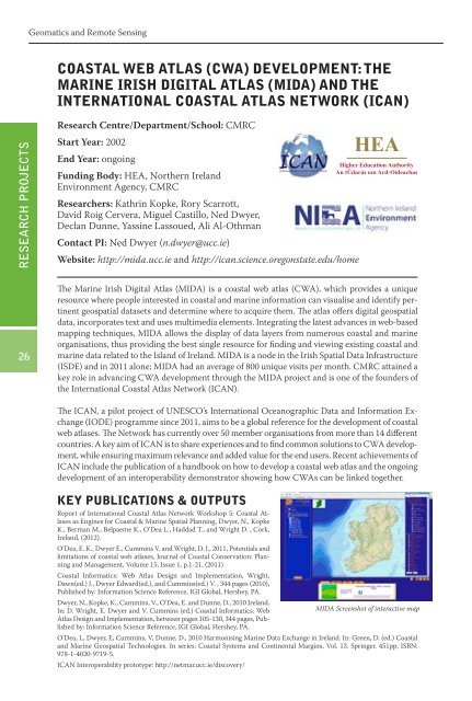
The Marine Irish Digital Atlas (MIDA) is a coastal web atlas (CWA), which provides a unique<br />
resource where people interested in coastal and marine information can visualise and identify pertinent<br />
geospatial datasets and determine where to acquire them. The atlas offers digital geospatial<br />
data, incorporates text and uses multimedia elements. Integrating the latest advances in web-based<br />
mapping techniques, MIDA allows the display of data layers from numerous coastal and marine<br />
organisations, thus providing the best single resource for finding and viewing existing coastal and<br />
marine data related to the Island of Ireland. MIDA is a node in the Irish Spatial Data Infrastructure<br />
(ISDE) and in 2011 alone; MIDA had an average of 800 unique visits per month. CMRC attained a<br />
key role in advancing CWA development through the MIDA project and is one of the founders of<br />
the International Coastal Atlas Network (ICAN).<br />
The ICAN, a pilot project of UNESCO’s International Oceanographic Data and Information Exchange<br />
(IODE) programme since 2011, aims to be a global reference for the development of coastal<br />
web atlases. The Network has currently over 50 member organisations from more than 14 different<br />
countries. A key aim of ICAN is to share experiences and to find common solutions to CWA development,<br />
while ensuring maximum relevance and added value for the end users. Recent achievements of<br />
ICAN include the publication of a handbook on how to develop a coastal web atlas and the ongoing<br />
development of an interoperability demonstrator showing how CWAs can be linked together.<br />
KEY PUBLICATIONS & OUTPUTS<br />
Report of International Coastal Atlas Network Workshop 5: Coastal Atlases<br />
as Engines for Coastal & Marine Spatial Planning, Dwyer, N., Kopke<br />
K., Berman M., Belpaeme K., O’Dea L., Haddad T., and Wright D. , <strong>Cork</strong>,<br />
Ireland, (2012).<br />
O’Dea, E. K., Dwyer E., Cummins V. and Wright, D. J., 2011, Potentials and<br />
limitations of coastal web atlases, Journal of Coastal Conservation: Planning<br />
and Management, Volume 15, Issue 1, p.1-21, (2011)<br />
Coastal Informatics: Web Atlas Design and Implementation, Wright,<br />
Dawn(ed.) J., Dwyer Edward(ed.), and Cummins(ed.) V. , 344 pages (2010),<br />
Published by: Information Science Reference, IGI Global, Hershey, PA.<br />
Dwyer, N., Kopke, K., Cummins, V., O’Dea, E. and Dunne, D., 2010 Ireland.<br />
In: D. Wright, E. Dwyer and V. Cummins (ed.) Coastal Informatics: Web<br />
MIDA Screenshot of interactive map<br />
Atlas Design and Implementation, between pages 105-130, 344 pages, Published<br />
by: Information Science Reference, IGI Global, Hershey, PA.<br />
O’Dea, L, Dwyer, E, Cummins, V, Dunne, D., 2010 Harmonising Marine Data Exchange in Ireland. In: Green, D. (ed.) Coastal<br />
and Marine Geospatial Technologies. In series: Coastal Systems and Continental Margins, Vol. 13. Springer. 451pp, ISBN:<br />
978-1-4020-9719-5.<br />
ICAN Interoperability prototype: http://netmar.ucc.ie/discovery/