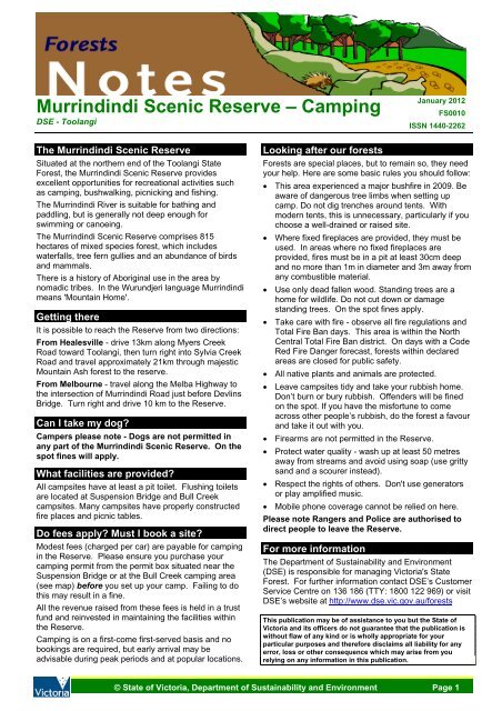
Murrindindi Scenic Reserve - Camping - Department of ...
Murrindindi Scenic Reserve - Camping - Department of ...
Murrindindi Scenic Reserve - Camping - Department of ...

You also want an ePaper? Increase the reach of your titles
YUMPU automatically turns print PDFs into web optimized ePapers that Google loves.
<strong>Murrindindi</strong> <strong>Scenic</strong> <strong>Reserve</strong> – <strong>Camping</strong><br />
DSE - Toolangi<br />
The <strong>Murrindindi</strong> <strong>Scenic</strong> <strong>Reserve</strong><br />
Situated at the northern end <strong>of</strong> the Toolangi State<br />
Forest, the <strong>Murrindindi</strong> <strong>Scenic</strong> <strong>Reserve</strong> provides<br />
excellent opportunities for recreational activities such<br />
as camping, bushwalking, picnicking and fishing.<br />
The <strong>Murrindindi</strong> River is suitable for bathing and<br />
paddling, but is generally not deep enough for<br />
swimming or canoeing.<br />
The <strong>Murrindindi</strong> <strong>Scenic</strong> <strong>Reserve</strong> comprises 815<br />
hectares <strong>of</strong> mixed species forest, which includes<br />
waterfalls, tree fern gullies and an abundance <strong>of</strong> birds<br />
and mammals.<br />
There is a history <strong>of</strong> Aboriginal use in the area by<br />
nomadic tribes. In the Wurundjeri language <strong>Murrindindi</strong><br />
means 'Mountain Home'.<br />
Getting there<br />
It is possible to reach the <strong>Reserve</strong> from two directions:<br />
From Healesville - drive 13km along Myers Creek<br />
Road toward Toolangi, then turn right into Sylvia Creek<br />
Road and travel approximately 21km through majestic<br />
Mountain Ash forest to the reserve.<br />
From Melbourne - travel along the Melba Highway to<br />
the intersection <strong>of</strong> <strong>Murrindindi</strong> Road just before Devlins<br />
Bridge. Turn right and drive 10 km to the <strong>Reserve</strong>.<br />
Can I take my dog?<br />
Campers please note - Dogs are not permitted in<br />
any part <strong>of</strong> the <strong>Murrindindi</strong> <strong>Scenic</strong> <strong>Reserve</strong>. On the<br />
spot fines will apply.<br />
What facilities are provided?<br />
All campsites have at least a pit toilet. Flushing toilets<br />
are located at Suspension Bridge and Bull Creek<br />
campsites. Many campsites have properly constructed<br />
fire places and picnic tables.<br />
Do fees apply? Must I book a site?<br />
Modest fees (charged per car) are payable for camping<br />
in the <strong>Reserve</strong>. Please ensure you purchase your<br />
camping permit from the permit box situated near the<br />
Suspension Bridge or at the Bull Creek camping area<br />
(see map) before you set up your camp. Failing to do<br />
this may result in a fine.<br />
All the revenue raised from these fees is held in a trust<br />
fund and reinvested in maintaining the facilities within<br />
the <strong>Reserve</strong>.<br />
<strong>Camping</strong> is on a first-come first-served basis and no<br />
bookings are required, but early arrival may be<br />
advisable during peak periods and at popular locations.<br />
January 2012<br />
FS0010<br />
ISSN 1440-2262<br />
Looking after our forests<br />
Forests are special places, but to remain so, they need<br />
your help. Here are some basic rules you should follow:<br />
• This area experienced a major bushfire in 2009. Be<br />
aware <strong>of</strong> dangerous tree limbs when setting up<br />
camp. Do not dig trenches around tents. With<br />
modern tents, this is unnecessary, particularly if you<br />
choose a well-drained or raised site.<br />
• Where fixed fireplaces are provided, they must be<br />
used. In areas where no fixed fireplaces are<br />
provided, fires must be in a pit at least 30cm deep<br />
and no more than 1m in diameter and 3m away from<br />
any combustible material.<br />
• Use only dead fallen wood. Standing trees are a<br />
home for wildlife. Do not cut down or damage<br />
standing trees. On the spot fines apply.<br />
• Take care with fire - observe all fire regulations and<br />
Total Fire Ban days. This area is within the North<br />
Central Total Fire Ban district. On days with a Code<br />
Red Fire Danger forecast, forests within declared<br />
areas are closed for public safety.<br />
• All native plants and animals are protected.<br />
• Leave campsites tidy and take your rubbish home.<br />
Don’t burn or bury rubbish. Offenders will be fined<br />
on the spot. If you have the misfortune to come<br />
across other people’s rubbish, do the forest a favour<br />
and take it out with you.<br />
• Firearms are not permitted in the <strong>Reserve</strong>.<br />
• Protect water quality - wash up at least 50 metres<br />
away from streams and avoid using soap (use gritty<br />
sand and a scourer instead).<br />
• Respect the rights <strong>of</strong> others. Don't use generators<br />
or play amplified music.<br />
• Mobile phone coverage cannot be relied on here.<br />
Please note Rangers and Police are authorised to<br />
direct people to leave the <strong>Reserve</strong>.<br />
For more information<br />
The <strong>Department</strong> <strong>of</strong> Sustainability and Environment<br />
(DSE) is responsible for managing Victoria's State<br />
Forest. For further information contact DSE’s Customer<br />
Service Centre on 136 186 (TTY: 1800 122 969) or visit<br />
DSE’s website at http://www.dse.vic.gov.au/forests<br />
This publication may be <strong>of</strong> assistance to you but the State <strong>of</strong><br />
Victoria and its <strong>of</strong>ficers do not guarantee that the publication is<br />
without flaw <strong>of</strong> any kind or is wholly appropriate for your<br />
particular purposes and therefore disclaims all liability for any<br />
error, loss or other consequence which may arise from you<br />
relying on any information in this publication.<br />
© State <strong>of</strong> Victoria, <strong>Department</strong> <strong>of</strong> Sustainability and Environment Page 1
Malaraway<br />
Rd<br />
Malaraway<br />
Rd<br />
Kalatha Creek Trk<br />
Aeroplane Trk<br />
Chevys Trk<br />
Mt Klondyke Rd<br />
<strong>Murrindindi</strong> <strong>Scenic</strong> <strong>Reserve</strong> - <strong>Camping</strong> FS0010<br />
To Devlins<br />
Bridge<br />
Toolangi<br />
State<br />
Forest<br />
Marginal Rd<br />
Walking Trk<br />
Kilmore<br />
!<br />
!<br />
To Yea<br />
Breakoday<br />
Trk<br />
Kalatha Rd<br />
Klondyke Rd<br />
Mount<br />
Klondyke<br />
Melbourne<br />
!<br />
<strong>Murrindindi</strong> Rd<br />
Horseyard<br />
Creek Trk<br />
Seymour<br />
!<br />
Whittlesea<br />
!<br />
Suspension Bridge<br />
Day Area<br />
g2nFJ<br />
Yea<br />
!<br />
Lilydale<br />
!<br />
Horseyard Creek Trk<br />
M2<br />
Myles<br />
Bend Dr<br />
Wilhelmina Falls Rd<br />
Blackwood Camp<br />
PM2F<br />
Cassinia Camp<br />
Healesville<br />
!<br />
Marginal Rd<br />
Alexandra<br />
!<br />
Mt Despair Rd<br />
!<br />
S E C Rd<br />
!<br />
SEC Picnic Area<br />
& Campground<br />
M2oFJ<br />
Water Gauge Camp<br />
PM2FJ<br />
Horseyard<br />
Creek Trk<br />
Marysville<br />
!<br />
Warburton<br />
!<br />
Mount<br />
Despair<br />
Mt Despair Rd<br />
Kalatha Rd<br />
Myles Rd<br />
Mansfield<br />
!<br />
Horseyard Creek Rd<br />
Dindi River Rd<br />
<strong>Murrindindi</strong> River<br />
Natural Features<br />
and <strong>Scenic</strong> Res.<br />
PM2F<br />
!<br />
!<br />
!<br />
PM2F<br />
Bull Creek Camp<br />
!<br />
o<br />
S E C Rd<br />
Tower Trk<br />
4<br />
Mill Track<br />
Loop<br />
!<br />
Ferns Camp<br />
Camp Creek Rd<br />
Cascades<br />
Picnic Area<br />
To Healesville<br />
Jamieson Trk<br />
Wilhemina<br />
Falls Walk<br />
!<br />
!<br />
Jacksons Rd<br />
4<br />
Boroondara<br />
Track Loop<br />
<strong>Murrindindi</strong> Rd<br />
Winch Rd<br />
!<br />
4<br />
4<br />
Falls Creek Rd<br />
<strong>Murrindindi</strong><br />
River Walk<br />
MELBOURNE ^<br />
Bull Creek Rd<br />
Garlick Trk<br />
Falls Creek Trk<br />
Map Scale<br />
Toolangi<br />
State<br />
Forest<br />
!<br />
This publication may be <strong>of</strong> assistance to you but the State <strong>of</strong> Victoria and its employees do not guarantee that the publication is without flaw <strong>of</strong> any kind<br />
or is wholly appropriate for your particular purposes and therefore disclaims all liability for any error, loss or other consequence which may arise from you relying on<br />
any information in this publication.<br />
© State <strong>of</strong> Victoria, <strong>Department</strong> <strong>of</strong> Sustainability and Environment.<br />
S Creek Rd<br />
Waterwheel Trk<br />
Mcclure Brk<br />
Jackson Brk<br />
Yea Rock Rd<br />
Jacksons Rd<br />
Ash Creek Rd<br />
North<br />
Eastern Rd<br />
1:50,000<br />
North<br />
Eastern Rd<br />
0 0.5 1 2<br />
Kilometers<br />
Waterwheel<br />
Trk<br />
Thompson Trk<br />
Olgas Trk<br />
Falls Creek Rd<br />
!<br />
Keltys Rd<br />
Yea Rock<br />
Friday<br />
Creek Rd<br />
±<br />
Produced by<br />
GIS Unit, Traralgon.<br />
November 2011.<br />
Water body<br />
Stream<br />
g Information board<br />
2<br />
M<br />
o<br />
Major sealed road<br />
Minor sealed road<br />
Unsealed road<br />
Black<br />
Range Rd<br />
Keltys Rd<br />
Minor unsealed road<br />
4WD vehicle track<br />
Walking track<br />
Parks and <strong>Reserve</strong>s<br />
State Forest<br />
Other Public Land<br />
Toilets<br />
P Caravan camp sites<br />
Tent camp sites<br />
Picnic Facilities<br />
J Footbridge access<br />
F Fireplace<br />
Black Range Rd<br />
Keltys Rd<br />
Robbie Rd

![Metcalfe State Forest Fauna Species List [PDF File - 16.9 KB]](https://img.yumpu.com/22024301/1/184x260/metcalfe-state-forest-fauna-species-list-pdf-file-169-kb.jpg?quality=85)
![PPE Price List for Wildlife Volunteers [PDF File - 20.3 KB]](https://img.yumpu.com/15321634/1/190x135/ppe-price-list-for-wildlife-volunteers-pdf-file-203-kb.jpg?quality=85)