Download Document - Washington Department of Fish & Wildlife
Download Document - Washington Department of Fish & Wildlife
Download Document - Washington Department of Fish & Wildlife

You also want an ePaper? Increase the reach of your titles
YUMPU automatically turns print PDFs into web optimized ePapers that Google loves.
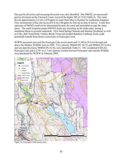
One gravity diversion and one pump diversion were also identified. Site 960302, an unscreened<br />
gravity diversion on the Chewuch Canal, received the higher SPI <strong>of</strong> 13.85 (Table 4). The canal<br />
diverts approximately 2.4 cfs (1,078 gpm) <strong>of</strong> water from May to October for residential irrigation.<br />
Flow downstream <strong>of</strong> this site received 0.4 cfs (180 gpm) for fish use at time <strong>of</strong> survey. Creek flow<br />
upstream <strong>of</strong> 960302 could not be determined because the canal and streambed occupy the same<br />
space. The small irrigation pump (960305) lacks any screening on the intake pipe, posing a<br />
mutilation threat to juvenile salmonids. ESA listed Spring Chinook and Summer Steelhead, as well<br />
as Coho, Bull Trout/Dolly Varden, Brook Trout and resident Rainbow/Cutthroat Trout could<br />
potentially benefit from barrier corrections on Pearrygin Creek.<br />
WDFW personnel surveyed the Pearrygin Lake access point and 15,190 m (9.4 mi) through and<br />
above the Methow <strong>Wildlife</strong> Area in 1999. Two culverts, 980649 (PI 20.75) and 980603 (PI 16.46),<br />
and one dam/diversion, 980604 (PI 14.76), were identified (Table 5). YIC completed ETDs for<br />
Pearrygin Lake and a 2,791 m (1.7 mi) riparian corridor between Pearrygin Lake and the <strong>Wildlife</strong><br />
Area purchased by WDFW in February 2005.<br />
Figure 10. Pearrygin Creek known sites.<br />
20